
|
|
Mountain/Rock |
|---|---|
|
|
48.21113°N / 117.97742°W |
|
|
Stevens |
|
|
Hiking |
|
|
Spring, Summer, Fall, Winter |
|
|
5825 ft / 1775 m |
|
|
Overview
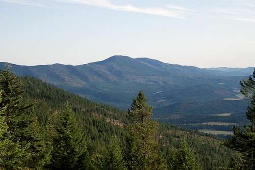
Huckleberry Mountain is a regionally significant peak in Stevens County, located in northeastern Washington. With a clean prominence of 3865', the peak is the 23rd-most prominent point in Washington. With the nearest higher ground being over 25 miles away, the peak is the 18th-most isolated point in Washington. Huckleberry Mountain
Huckleberry Mountain is locally important as a site of active logging as well as a hunting area. However, the peak is also important to some peakbaggers for the reasons mentioned earlier. The summit approaches are non-technical, with drives up dirt logging roads and hikes up semi-open forested slopes. Although the peak looks like an ordinary forested mountain, the summit ridge is almost completely a rocky spine.
 Rocky Spine Of Summit Ridge
The northern highpoint of Huckleberry Mountain is the false summit, only three feet elevation lower than the true summit (5822' vs. 5825') located a short distance south along the same ridge. The false summit has great views, involves an interesting ascent (Class 2 rocky scramble), and has an actual USGS Benchmark (titled "NO HUCK"). For those reasons, the false summit is a recommended visit. However, to claim a successful summit a person must visit the true summit, located only a few minutes south of the false summit. The true summit is an otherwise insignificant-looking rocky rib with decent eastern views but no USGS Benchmark.
 USGS Benchmark ("NO HUCK") At False Summit
 Rocky Scramble Leading To False Summit
Huckleberry Mountain likely received its name in reference to the many mountain huckleberries found in the area that were used as important Autumn crops of local Indian tribes for many years.
Getting There
STARTING FROM THE INTERSECTION OF HIGHWAY 25 & CEDONIA-ADDY ROAD (WEST OF CEDONIA, WA):
1) Drive east for 9.4 miles along Cedonia-Addy Road.
2) Make a hard right turn onto Locke Road.
3) Follow the main road towards Huckleberry Mountain, as it ascends east, then south, and then northeast towards the northern ridgeline of the peak. The goal is to end up on the uppermost logging road located on the western side of the mountain. Please use a map and GPS device to verify the correct route is being used, based upon which roads are available at the time of visit.
NOTE: The dirt road system that is used to approach Huckleberry Mountain is also used for logging activities. Access might be changed or closed without notice, as a result of those logging activities. From the intersection of Cedonia-Addy Road and Locke Road, it is ~4.5 miles to where the closest road meets the upper northern end (~5100' elevation) of the summit ridge, or ~6.0 miles to the road crest (~5400' elevation). The former option is a shorter and more-direct hike, but the latter option provides a wider area for which to turn around/park vehicles as well as ascend the most open forested slopes of the peak. Either option works.
4) Hike from the road up the upper forested slopes to the summit ridge, and then to the true summit.
 Example Of Semi-Open Forested Slopes
 True Summit
Red Tape
 Huckleberry Mountain
The dirt roads and slopes on and around Huckleberry Mountain are the sites of active logging. Logging activities have the "right of way" on all approach roads beyond Cedonia-Addy Road. It is because of this aspect that Huckleberry Mountain is best recommended during weekends and holidays, while logging activities are at a minimum (if present at all).
Huckleberry Mountain is the site of some hunting activities. If visiting the peak during hunting season, make certain to wear "hunter orange" colors as a precaution.
Huckleberry Mountain is open to public access. No special permits or parking passes are required to visit the peak.
The dirt approach roads are currently manageable by virtually any street-legal vehicle. However, due to constant logging activities and lack of regular road maintenance the road conditions will probably worsen over time. The dirt roads are not recommended for travel during wet and muddy conditions. High-clearance vehicles are recommended, but currently not required.
Camping
No camping is allowed on the mountain.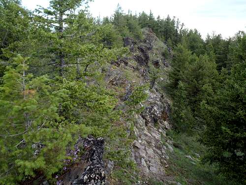 Summit Ridge
Dundeel - Aug 4, 2012 11:55 pm - Voted 10/10
Red Marble MineAnother interesting thing to add to the Overview, would be Red Marble Mine on the east side. Although marble was present, it appears that the main target was red magnesite that is used primarily to line steel furnaces.