
|
|
Mountain/Rock |
|---|---|
|
|
48.37179°N / 119.06124°W |
|
|
Okanogan |
|
|
Hiking |
|
|
Spring, Summer, Fall, Winter |
|
|
6774 ft / 2065 m |
|
|
Overview
 Moses Mountain
Moses Mountain is major peak located into Okanogan County, Washington. The mountain is significant to local Native American tribes and was named after a famous chief. In addition, the mountain is significant to peakbaggers by being one of the most prominent peaks in Washington, as well as being one of the most isolated peaks.
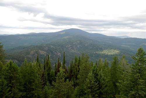 Photo Displaying Prominence And Isolation
Moses Mountain was named after Chief Moses, a late-1800s chief of the Sinkiuse-Columbia tribe once located in what is now north-central Washington. Chief Moses was born with the name of Kwiltalahun, but later assumed his father's name if Sulk-stalk-scosum (which means "The Sun Chief"). He was given the Christian name Moses by a missionary in Idaho while he was an adolescent, despite never proclaiming to be a Christian. He used the Moses name for the rest of his life, especially when interacting with settlers.
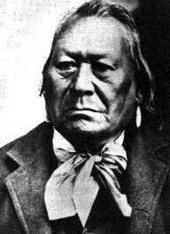 Chief Moses
The Sinkiuse-Columbia tribe had a territory that reached from Waterville (in what is now central Washington) to the Columbia Basin near White Bluffs (in what is now southern Washington). Moses was chief of the tribe for forty years, during a timeframe when unrest between local tribes and settlers was escalating rapidly. Chief Moses was accused of murdering a couple of settlers during 1878, which prompted him to be invited to Washington, D.C. during 1879 to discuss settler-tribal relations. After the visit Moses was acquitted of all charges, although it was widely speculated that his acquittal was dependent upon his agreement to have his tribe placed on a new Columbia Reservation to be created that year.
Chief Moses and his tribe agreed to give up their land for homesteading and be placed on the Columbia Reservation. Unfortunately, the reservation had similar boundaries to the Okanogan and Similkameen Mining District, threatening to displace many activities and settlers within that region. Eventually, after much hostility and rising tensions, the government purchased the Columbia Reservation land from the Sinkiuse-Columbia tribe. The Columbia Reservation was officially returned to the public domain during 1884, and much of the Sinkiuse-Columbia tribe moved onto the neraby Colville Indian Reservation. Chief Moses had lived nearly the last two decades of his life on the Colville Indian Reservation, until his death in 1899. He was buried in Nespelem, and Moses Mountain was named in his honor. Moses Lake and Moses Coulee were also named in his honor.
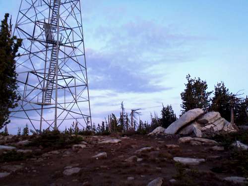
Currently, Moses Mountain is perhaps most famous for its fire lookout. The first fire lookout on the peak was a wooden platform built during 1914 atop a tall tree that had a cabin nearby. During 1923, a 30'-tall pole tower replaced the tree. During 1930, a 35'-tall steel tower was constructed at the summit. During 1938, the present 123' Aermotor steel tower was constructed, and the 1930-built 35'-tall steel tower was removed several years later. Although the fire lookout has not been in use since the mid-1980s, it is still the tallest lookout tower in the Pacific Northwest, if not the entire western United States.
 Fire Lookout
Moses Mountain is also significant to many local peakbaggers. The mountain is one of only 18 Washington peaks that has at least 4000' of prominence. Of those 18 peaks, Moses Mountain might be the simplest to summit. During periods of no snowpack, the peak is a drive-up at its easiest or a eight-mile roundtrip road hike at its most difficult.
 Summit Road
Moses Mountain is also one of only 18 Washington peaks to have at least 25 miles of isolation from the nearest higher ground. In fact, Moses Mountain is the most isolated point in all of Okanogan County, which is a large and mountainous county. Only eight peaks in Washington have a combination of at least 4000' of prominence and at least 25 miles of isolation, which includes Moses Mountain despite it being the lowest elevation peak (6774') in that group.
 Summit Lookout And Summit Rock Outcrop
Getting There
FROM HIGHWAY 97 AT OMAK, WA:
1) Turn west at Dayton Street (lighted intersection).
2) Drive 0.2 miles to a stop sign. Turn right onto Omak Avenue/ Highway 155, heading southeast towards Nespelem and Grand Coulee Dam.
3) Drive 18.4 miles along Highway 155. Turn left (east) onto BIA-56, which is a dirt road.
NOTE: There might be a small sign for Moses Mountain Lookout at the road entrance.
4) Drive 5.3 miles along BIA-56. Turn left (north) onto BIA-61, which is a dirt road that leads to the summit of Moses Mountain.
NOTE: There might be a small sign for Moses Mountain Lookout at the road junction.
 Directional Sign
NOTE: The entrance to BIA-61 has a gate. If the gate is closed, park on the side of the road and hike to the summit. If the gate is open, proceed with driving (see instructions below).
5) Drive approximately four miles along BIA-61, gaining nearly 2200' elevation, until reaching the summit.
NOTE: BIA-61 is a dirt road full of ruts, rocks, potholes, and switchbacks. Nearly every switchback allows enough off-road room for a vehicle to park. Potential summiters should do whatever makes them comfortable; that road is not in a favorable location for a vehicle to breakdown.
Red Tape
Moses Mountain is located on the Colville Indian Reservation. The standard summit approach uses Highway 155, which is a public highway maintained by the county and state, as well as BIA-56 and BIA-61, which are dirt roads maintained by the Bureau of Indian Affairs (BIA). Stay on roads and do not traverse any off-road land. There are currently no signs or laws forbidding public access to Moses Mountain, or any statements to that effect on the official Colville Indian Reservation website. However, if a tribal member (especially a tribal police officer) asks a potential summiter to leave please respect those wishes and do so without question. It is possible that the Colville Indian Reservation might impose future restrictions or requirements to non-members, such as use permits and/or ascents accompanied by reservation members. Please check for current requirements and visitation conditions prior to any visit to Moses Mountain or the Colville Indian Reservation.BIA-56 and BIA-61 are both dirt roads. These roads can become potentially troublesome if wet and/or muddy. It is only recommended to drive these roads during dry conditions. Currently, a high-clearance vehicle is not required on either road but is certainly advised.
There are several radio facilities and structures located at the summit. Do not attempt to enter, alter, or disrupt these facilities.
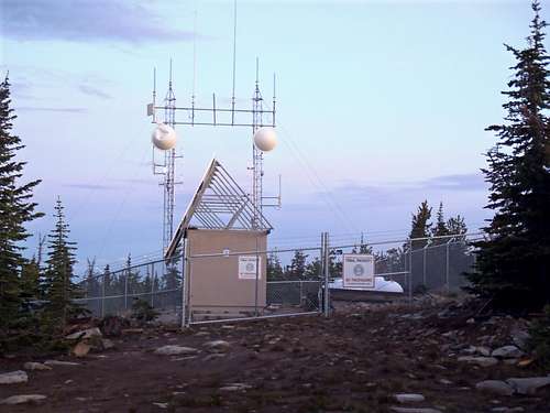 Radio Facility At Summit
Camping
There is no camping allowed on Moses Mountain. Moses Mountain, As Seen From Tunk Mountain