
|
|
Mountain/Rock |
|---|---|
|
|
37.54360°N / 112.8232°W |
|
|
Kane |
|
|
Hiking |
|
|
Summer, Fall |
|
|
10080 ft / 3072 m |
|
|
 The highpoint of the county
Overview
Utah has 29 counties and thus it has 29 county highpoints. A few manage to share the same highpoint so when you get one, you get another (One example: Delano Peak is the highpoint for Iron and Piute counties) Most of these highpoints are on top of a mountain as you would expect but in a few cases, the highpoint is what they refer to as a liner since the land in the neighboring county in this case is higher. Kane county is stuck with that situation where its highest point it on the side of a mountain that is in a neighboring county and so, a study of topographical maps has located the highest spot of land as HERE (topozone map). The actual highest peak in Kane county is Andy Nelson Peak, located a few miles to the south and it can be a bit confusing to some who think that Andy Nelson Peak is the county highpoint and then find out that while it is the highest peak, it isn't the highest spot in Kane county. That "honor" is given to a place on the side of Iron County to the north where the actual county line resides at an elevation of 10080', 53 feet higher than the top of Andy Nelson Peak. Hopefully, that may help to clear up
this somewhat confusing situation as one realizes that the highest point of Kane county is a "liner". OK, moving forward....
So what fun is it to do a "liner"? Well, it can be kind of like looking for a geocache instead of climbing a peak. Or as my son put it, "Dad, this is like a treasure hunt". Here is a deal where you get to put your map and compass skills to use or cheat a bit and use modern technology's wonder child, GPS. Following a pre set coordinate to your goal is fun for me and it is this very concept that has popularized the "sport" of geocaching. Granted, Summitpost is about peaks and mountains although the new version has also recognized canyons, waterfalls, and even seashores. Considering that this particular county highpoint is located at an elevation of over ten thousand feet, is subject to snow, thunderstorms and other weather conditions that are often less than desirable, you still are in the mountains and you still can get a mountain feel to this specific highpoint.
Kane County does have a peak that just missed being the highest point in the county by a mere 53 peak but I would refer you to the excellent book, "High in Utah" for a detailed description and map of that peak.
More on Utah Counties can be found HERE at the county highpointing site.
Now let me get you close enough for you to find it for yourself.
Getting There

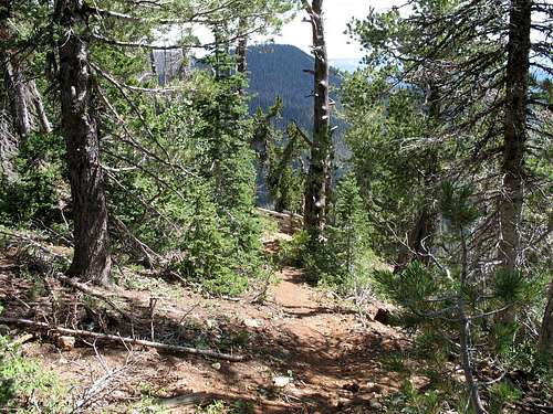
Most people would approach this from I-15 and Cedar Cedar. From Cedar City, take Utah highway 14 18 miles to highway 148 which turns off to go to Cedar Breaks and Brian Head. Continue on Highway 14 another 4.4 miles and watch for a road that heads off to the right called Deer Valley road. Drive 1.5 miles up the Deer Valley road to its junction with FS 1642. Turn left on FS 1642 and proceed past a point where FS 1642 starts to curve back to the left. A road FS 1646 takes off to the left uphill but do not take that branch. Continue on a bit to where I found a spot off the road to park HERE (topozone) and then just walk the last 1/3 rd of a mile, you need the exercise anyway. The elevation of where I parked was 9980 so you don't have a lot of elevation gain to deal with. Also note that there is a couple markers that refer to this road as the Marathon Trail. Another sign is encountered that refers to an overlook and I will take you there after we get to the highpoint.
Red Tape
None that I am aware of at this time. The area is in the Dixie National Forest with headquarters in Cedar City Utah.Dixie National Forest
1789 North Wedgewood Lane
Cedar City, UT 84720
(435) 865-3700

Camping
The Te-Ah Campground near Navajo Lake has water and restrooms.There are a couple of small campgrounds on Highway 14 on the way up from Cedar City:
Deer Haven
Cedar Canyon
Also, Cedar Breaks has a campground
Cedar Breaks Campground
More on Campgrounds HERE
The Weather

Kane County facts
The weather at nearby Brian Head is what you can expect to encounter when you seek out the Kane county highpoint as both are similar in elevation. The road to the highpoint is under snow until June most years so this one is best left until the snow has a chance to melt out.Kane County is a county located in the U.S. state of Utah. As of 2000 the population was 6,046, and by 2005 had been estimated at 6,202. It was named for Col. Thomas L. Kane, a friend of the Mormon settlers. Its county seat and largest city is Kanab.
Geography
The Colorado River, reformed as Lake Powell, forms its eastern boundary. Arizona lies on the southern boundary. Grand Staircase-Escalante National Monument covers much of the county. A rugged and inhospitable country of deserts, mountains and cliffs makes up the terrain, with breath-taking scenery in every area.
Kanab is a city in Kane County, Utah, United States. The population was 3,564 at the 2000 census. It is the county seat of Kane County. Locals refer to Kanab as "Little Hollywood" due to its history as a filming location for western movies. Kanab is situated centrally between Bryce Canyon National Park, the Grand Canyon (North Rim), and Zion National Park.
 What do you do after you climb the 7 Summits?
Andy Nelson Peak
There are some who mistakenly think that this is the highest point in Kane County. Alas, it isn't,it is the highest peak in Kane county but it isn't the highest point since the "liner" as described by this summitpost page is 53 feet higher than Andy Nelson Peak. To claim the county, you need to do the "liner" although Andy Nelson Peak would be more desirable since most of us really dislike "liners". Kirt Davis has put up a nice page for Andy Nelson Peak HERE.In the "High in Utah", both Andy Nelson Peak and the truest highpoint are discussed.
The Overlook
After you visit the highpoint, when you get back out of the brush and woods to the road you walked in on, continue on the road to the south a bit and you will find your way to the 'overlook'. From here you get a view of the land southward which includes the peak that is the highest prominence peak in Kane county as well a chance to see the northern part of Zion National Park. Views are limited due to the neighboring trees but you still get a feel for this area. Signal Peak, the highpoint of Washington County is visible to the southwest.
Be sure to read Scott Surgents neat trip report on his visit to Kane County.
You can find it HERE.
Trip Report by one of county highpointings pioneers
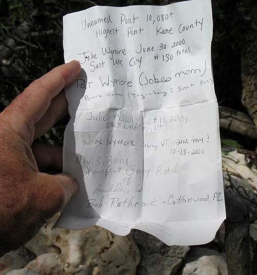
Kane County Highpoint Trip ReportDate: May 26, 2004 Author: Andy Martin
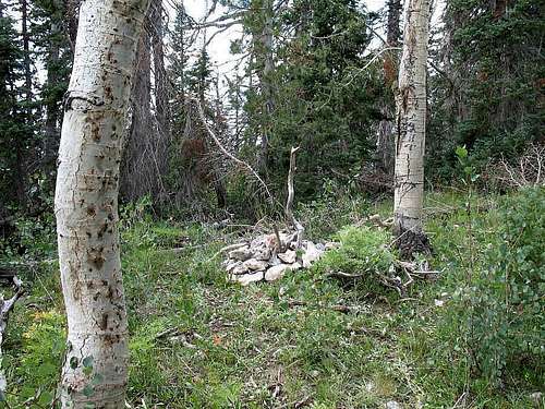
We revisited this county, and I relocated my former cairn about 50 yards (150 feet) to the southeast. The old cairn was changed into a big arrow pointing to the new location.
On my first visit I did not have a GPS unit, but used a line of trees to determine east/west bearing. As seen here this line of trees, formed by logging, does not run east/west, but northwest/southeast. This resulted in me going too far north and even though I ended up heading quite a ways south towards higher ground, the cairn was almost surely placed north of the Kane county line.
I was helped quite a bit on my return visit by the air photos that briefly appeared on the Topozone site (now require a fee to access). The Terraserver site no longer supports topo maps, and will not let you zoom in far enough on their air maps.
However, when Topozone did support free photos I came up with a GPS coordinate of NAD27 UTM (338925 E, 4156529 N). On the air photos this is at the northwest corner of a logged area.
This logged area is small, and the southwest most shown on the Terraserver link above. To get to the "new" cairn hike to the end of the dirt lane shown touching the south line of section 36 (this is at the county line). There is a 4 way intersection near here, at the middle of a logged strip (now regrown with 20-foot aspen trees). Continue straight through the 4 way intersection, pass through a strip of non-logged forest, and reach the final logged area, just before the plateau drops off from 10,000+ to 9,000 feet.
Just a few yards into this logged area the road curves to the northwest. This is a good place to fire up the GPS if you have one. I experienced poor GPS accuracy here due to tree blockage. Proceed perhaps 500 feet to the end of the road, and head to the north edge of the logged area. A foot high cairn is at edge of the trees, with the register jar and skull.
Those who wish to go the extra mile can head short distances northwest and southwest along the high ground. Although the cairn is probably still not precisely on the Kane county line (and HP), I believe it is closer than the former location - hopefully within 30 feet.
The topozone map at my GPS coordinates is here, and corresponds to (37.5435° N, 112.8233° W) using the NAD27 datum. The red target is slightly off the line in this view, but on other magnifications is right on the line - go figure.
Road conditions were hampered by snow but I barely managed to get the Accord to within 3/4 mile of the top. A rocky patch is found just southwest of the word "Deer" in the lettering "Deer Valley" on the quad. Those who park at this spot have an additional mile (each way) to stroll. Someone was bush camped at this spot and the meadow edge is a popular bush camping location in the summer.
----------------------------------------------------
The following is an excerpt (linked to above) from an interview that explains how Andy Martin got into County Highpointing:
What got you started on county highpointing?
After I had done most of the states (49), I was looking for something else.
We've really got it good in the USA. We've got good roads. Most of the highpoints are accessible politically. There are liaisons with the private highpoints. In Mexico you run the risk that some of the highpoints could be on some drug lord's private realm. You really have to know what's going on down there before you go.
Specifically what got you going on county highpoints?
Counties are the next level of granularity after states. That was one of the big motivations for me. I wanted to keep highpointing. The main thing for me is the mountain. I'm not that interested in the county history so much or going to the county courthouse as some guys do. I wanted to keep going to the mountains.
My long time friend Guy Cloutier told me about the pioneer of county highpointing, a fellow named "Altimeter" Bob Walko. He was called "Altimeter Bob" because he hiked around with a big aircraft altimeter. Bob identified and climbed the Arizona county highpoints way back in 1977. I gave Bob a call, and he got me hooked on the idea of following in his footsteps in Arizona. For me the state highpoints always came first, but I sort of migrated into county highpoints after fulfilling my dreams in the state arena.
Be sure to read all of the interview. Andy Martin published the book "County Highpoints"
More about the book:
County High Points by Andy Martin - a fuller description.
This 128 page soft cover, comb bound 8.5" x 11" book lists the 3,140+ county highpoints for all 50 states. Lists are also given for high prominence peaks and National Park HPs. The introduction goes into some detail on how the lists were prepared.
The information in the lists can be used to look up highpoint area maps on Topozone. For example, the Pima county Arizona high point is listed:
COUNTY HIGH POINT ELEV. LOCATION USGS 7.5' MAP
Pima Mount Lemmon 9,157 26-11S-15E Mount Lemmon
On Topozone enter "Mount Lemmon" as a place name. Click on the name Mount Lemmon from the resulting list, and you get the 1:100,000 scale map. Zoom in to 1:25,000 scale for a nice, printable summit map.
Lists are also available for the 50 "finest" peaks in 14 western states - AZ, CA, NM, NV, CO, UT, TX, OR, WA, ID, MT, WY, HI and AK. Finest lists for the NE and SE sections of the US are also included. Finest refers to the peaks with greatest prominence.
To order send a check for $12 to:
Andy Martin
3030 N. Sarsaparilla Pl.
Tucson, AZ 85749-9237
Nearby County Highpoint
Iron County's Brian Head Peak is less than an hour's drive from this one.Consider adding it to your trip and take in the views and vista to be enjoyed at Cedar Breaks National Monument that it on the way.
vanman798 - Aug 8, 2022 10:14 am - Hasn't voted
Not true"One example: Delano Peak is the highpoint for Iron and Piute counties" not true... Delano is HP of Beaver and Piute