
-
 707 Hits
-
 77.48% Score
-
 8 Votes
|
|
Mountain/Rock |
|---|---|
|
|
39.17609°N / 105.42636°W |
|
|
Hiking, Skiing |
|
|
Spring, Summer, Fall, Winter |
|
|
11403 ft / 3476 m |
|
|
Overview
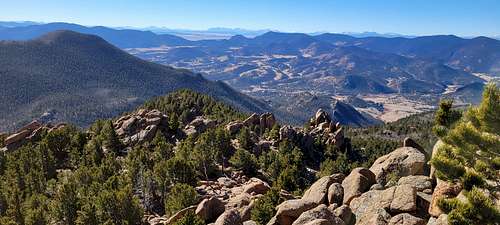
''Lake Park Peak''
Elevation: 11403 ft / 3475 m
Lost Creek Wilderness
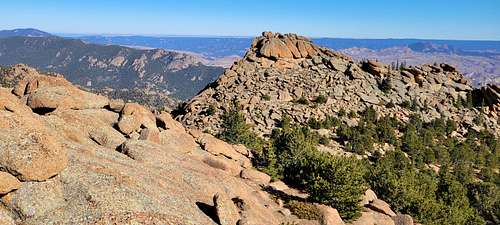
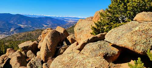
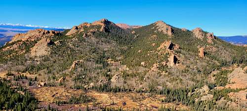
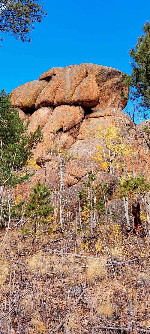
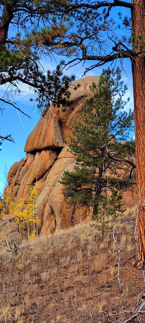
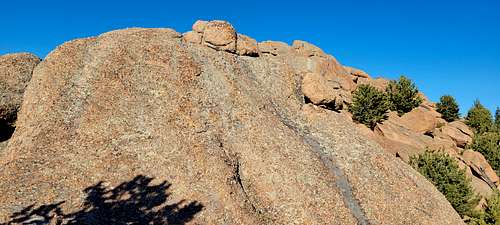
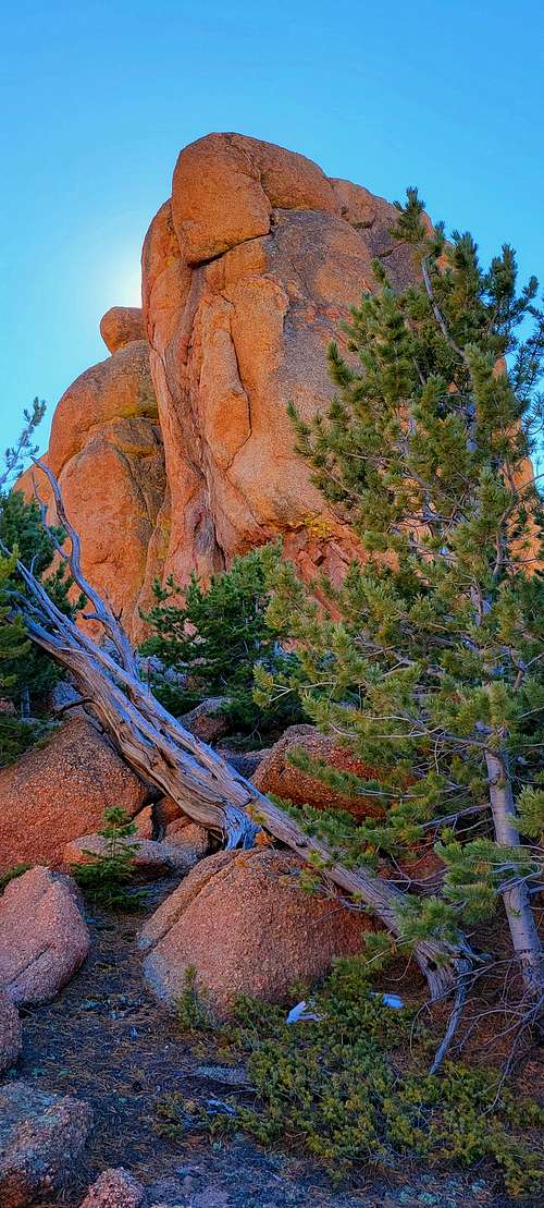
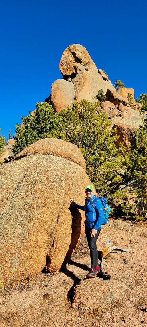
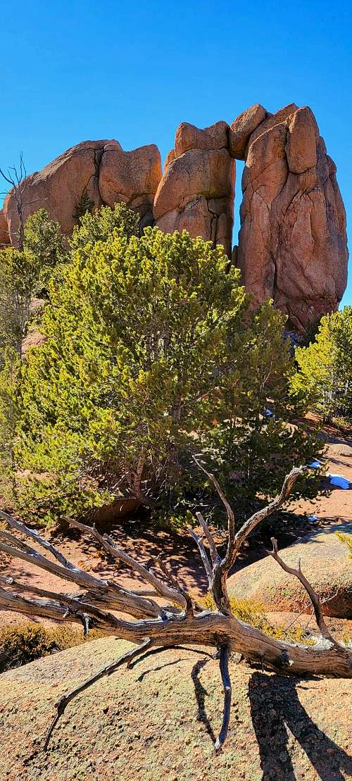
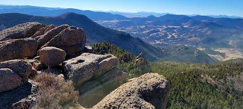
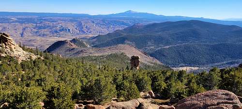
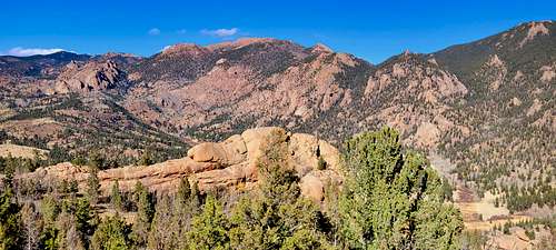
The summit of "Lake Park Peak" is isolated from the rest of the Tarryall Massif. This mountain actually has two summits, the west summit being the slightly higher of the two. The vast Lake Park area separates "Lake Park Peak" from its higher neighbors. The peak has a rough and very jagged south ridge that offers excellent scrambling plus, it's really nice to view. From the summit, you get a comprehensive view of the damage left behind from the Hayman Fire of 2002.
 |
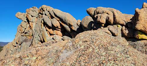 |
At Hankins Pass, go northwest and locate the Lake Park Trail and continue another mile to pass at 10,900-ft. This pass is the beginning of Lake Park. At this point, leave the comforts of the easy trail and start hiking towards "Lake Park Peak's" knobby south ridge. You can see "Lake Park Peak" resting a half-mile away. From this vantage, you actually see the higher of this peak's two summits. Once you attain the south ridge at 11,100-ft., cross to the south side and pick your way up the rough ridge. Traverse around the right side of the west summit block and ascend north up a v-notch in the ridge. A class 2+ move gets you directly on the ramp that will get you to the summit. This is the higher of the two summits.
I highly recommend Lake Park's east summit as well. It's just a short class 3 scamper away and the views of the Hayman burn area are better from this vantage. Descend the west summit and cross an open saddle. The east summit is more difficult to ascend, but if you locate the steep ramp ascends from right to left it is only class 3.
 |
 |
Getting There
 |
 |
 |
SPRUCE GROVE TRAILHEAD
This trailhead provides access to the Lost Creek Wilderness via the Lizard Rock Trail. The Wilderness boundary is located near the trail's junction with the Hankins Pass Trail.
Directions:
From Colorado Springs:
Drive west from Colorado Springs on US 24 approximately 35 miles to Lake George. Just beyond Lake George, turn right on the Tarryall Road (County 77) and drive approximately 13.5 miles to the Spruce Grove Campground. Trailhead parking is just off the Tarryall Road outside the campground entrance.
Spruce Grove TH-8,560-ft
From Denver Colorado travel Hwy 285 past Aspen Park, Conifer, Pine Junction and Bailey. It is only one hour from Denver to Kenosha Pass. Continue to the tiny town of Jefferson and turn left on Park County 77 (Tarryall Road). This road is located directly before Jefferson's only convenient store. Continue 16.9 miles on the convenient paved road to Tarryall Reservoir. Pass the Ute Creek Trailhead, 3.3 miles beyond Tarryall Reservoir. Continue another 4.7 miles to the Spruce Grove Campground turnoff. There is plenty of parking. There is also camping at the trailhead, I believe it is $7.00 a night. It shouldn't take more than two hours to get to this TH.
Twin Eagles TH-8,540-ft
From Denver Colorado, travel Hwy 285 past Aspen Park, Conifer, Pine Junction and Bailey. Continue to Kenosha Pass where you will find the Kenosha Pass Campground. It is only one hour from Denver to Kenosha Pass. Continue to the tiny town of Jefferson and turn left on Park County 77 (Tarryall Road). This road is located directly before Jefferson's only convenient store. Continue 16.9 miles on the convenient paved road to Tarryall Reservoir. Continue passed the Ute Creek Trailhead at 3.3 miles beyond Tarryall Reservoir. Continue another 3 mile to the signed "Twin Eagles TH" turnoff. There is plenty of parking. It shouldn't take more than two hours to get to this TH.
 |
 |
Route
 |
 |
 |
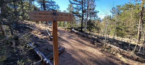
The Hankins Pass Trail is the southernmost trail in the Lost Creek Wilderness. From the east, the trail passes through dense forest to pleasant open meadows and aspen groves. From the junction with the Lake Park Trail at the top of Hankins Pass, the trail drops down the west side of the Tarryall Mountains to a junction with the Lizard Rock Trail, and then continues to descend to meet the Brookside-McCurdy Trail.
There are horse corrals near the Goose Creek Trailhead that are available for public use. There are a number of campsites between the trailhead and Hankins Pass. However, there are few areas suitable for camping west of the pass due to the steep gradient of the trail.
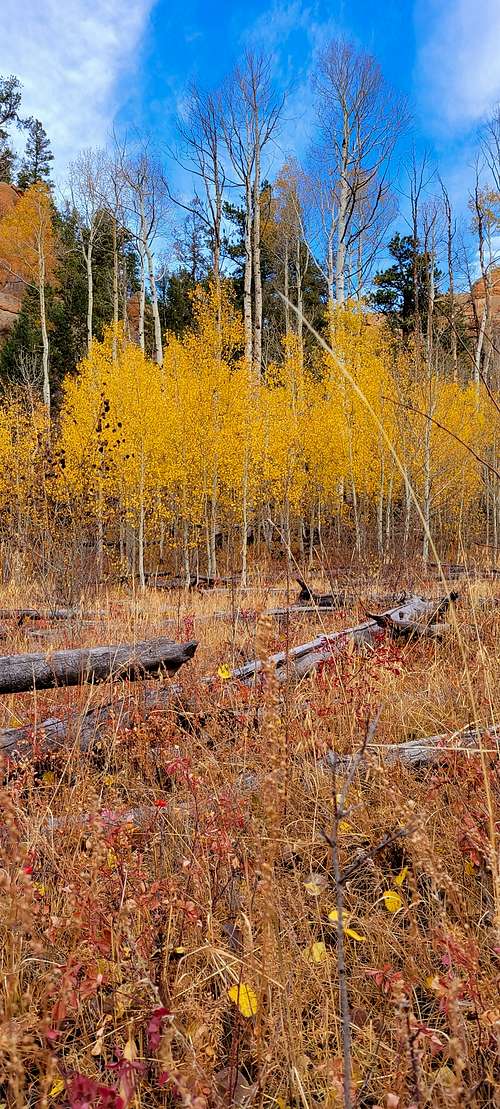
From the Goose Creek Trailhead, hike downhill to a footbridge across Hankins Gulch. Just across the creek, the Hankins Pass Trail heads west (left), while the Goose Creek Trail goes east (right). Climbing at first up through a forested valley, the trail eventually reaches a series of open meadows surrounded by aspen groves. The trail from here to the pass is beautiful in late September when the aspen leaves are changing color. At the top of Hankins Pass is a junction with the Lake Park Trail, which heads north (right) toward Lake Park, while the Hankins Pass Trail begins it's descent to the west.
The grade on the west side of the pass is quite a bit steeper than the gradual rise up to the pass from the east. After a short descent, the trail reaches the wilderness boundary and the junction with the Lizard Rock Trail. The Lizard Rock Trail leads south to the Spruce Grove Campground, while the Hankins Pass Trail continues down in a northwesterly direction to its end at the junction with the Brookside-McCurdy Trail.
 |
 |
Red Tape
The Forest Service is implementing a mandatory self-issuing permit system in the Mount Evans and Lost Creek Wildernesses to enable us to better manage these heavily visited Wildernesses. The same type of system is already in place in other Wildernesses. The intent is to use the data obtained through this permit system to more accurately assess the amounts and types of existing Wilderness use. This will enable us to better preserve their natural condition for future generations, balanced against the pressures of growing populations and increased use. These permits have no quotas associated with them nor will there be any fees required to obtain them. They will be available free at each trailhead. As you enter the Wilderness, fill out the provided permit and deposit the white paper copy in the slot in the lower front of the register box. Keep the yellow tag in your possession and please follow the Wilderness regulations found on the back.
 |
 |
At a Glance
|
Fees: |
No fee, however, campground fees apply when staying at nearby developed sites. |
|
Permit Info: |
There is a mandatory self-issuing permit system in the Mount Evans and Lost Creek Wilderness areas to enable us to better manage visitation. The same type of system is also in place in other Wildernesses. The intent is to use the data obtained through the permit system to more accurately assess the amounts and types of existing Wilderness use. This enables us to better preserve their natural condition for future generations, balanced against the pressures of growing populations and increased use. These permits have no quotas associated with them nor are there any fees required to obtain them. They are available free at each trailhead. As you enter the Wilderness, fill out the provided permit and deposit the stub in the slot in the lower front of the register box. Keep the permit in your possession and please follow the Wilderness regulations found on the back. |
|
Restrictions: |
Wilderness regulations apply The following are prohibited in the widerness area: 1. Having more than 15 persons and/or 10 saddle, pack, or draft animals accompanying any one party. 2. Possessing dogs, unless under physical restraint of a leash, except for working stock dogs, or dogs being used for legal hunting purposes. 3. Camping within one hundred (100) feet of lakes, streams, and forest development trails. 4. Building, maintaining, attending, or using a campfire or stove fire within one hundred (100) feet of lakes, streams and forest development trails. 5. Hitching, hobbling, or tethering any pack or saddle animal within one hundred (100) feet of lakes, streams, and forest development trails. 6. Possessing, storing, or transporting unprocessed plant material such as hay, straw, or other unprocessed livestock feed for bedding, feeding, or other uses. 7. Possessing or using a bicycle, wagon, cart, or other vehicle. Wheelchairs designed solely for and used by mobility-impaired persons for locomotion and which are suitable for indoor pedestrian use, are exempt from this regulation. 8. Short-cutting a switchback on a forest development trail. |
|
Closest Towns: |
Jefferson is at the northern end and Lake George is at the southern end of Lost Creek Wilderness. |
|
Water: |
At developed campgrounds when the campgrounds are open. |
|
Restroom: |
At developed campgrounds when the campgrounds are open. |
|
Information Center: |
South Park Ranger District - (719) 836-2031 |
General Information
Directions:
Access to Lost Creek Wilderness can be made a number of ways. It is recommended that you have a Pike National Forest Map, USGS, and/or National Geographic Trails Illustrated topograhical map for detailed information about getting into, being in, and getting out of the wilderness area.
When to Climb
Add When to Climb text here.
Camping
Lost Creek Wilderness offers a great variety of recreational opportunities. There are many miles of trail in or near the wilderness area and all wilderness regulations apply. Trails in the wilderness area are for foot traffic only and not open to motorized vehicles or bicycles.
Lost Creek Wilderness is located in Pike National Forest and the trails and campgrounds on the west side are taken care of by the South Park Ranger District.
Lost Park, Spruce Grove, and Twin Eagles Campgrounds are located adjacent to Lost Creek Wilderness on the west side. Lost Park and Twin Eagles are first come, first served and Spruce Grove can be reserved at Recreation.gov.
Trails and campgrounds on the east side are managed by the South Platte Ranger District.
External Links
https://www.peakbagger.com/peak.aspx?pid=59826
https://listsofjohn.com/peak/2162