Overview
![Kenosha Peak Summit looking west-northwest]() Looking west-northwest from the ridge northwest of "Kenosha Peak". South Twin Cone Peak (12,265) is in the midground.
Looking west-northwest from the ridge northwest of "Kenosha Peak". South Twin Cone Peak (12,265) is in the midground.
“Kenosha Peak”, an officially unnamed but ranked Colorado 12er, is the northernmost of the Kenosha Mountains. Sitting quietly off of the Ben Tyler Trail in the
Lost Creek Wilderness, free from the burden of a trail to the summit, this mountain calls for lovers of peace and quiet to stroll upon its broad summit plateau and take a seat on the conveniently inclined summit block. Unsung and relatively unvisited, what this mountain lacks in grandeur it will make up for in solitude and eye-popping views from the summit.
From the summit of this gentle 12er, the hiker can take in up-close views of South Twin Cone Peak,
North Twin Cone Peak, Mount Blaine and Foster to the northwest. To the southeast the foreground in dominated by Kenosha Mountains siblings X Prime Peak, Peak X and Peak Y. Shawnee Peak and its family of remote 11ers can be enjoyed by looking to the east.
The large complex of beaver ponds accompanying the hiker on the lower reaches of the Ben Tyler Trail from the South Ben Tyler Trailhead are a special treat.
Kenosha Mountains
For an excellent geological history of the Kenosha Mountains and details about the nearby peaks, please visit this informative
Kenosha Mountains page.
Colorado Rank: 1,252nd highest mountain in Colorado
Colorado 12ers: 615th highest 12er in Colorado
Prominence: 320 feet
Route: Rock Creek Route via South Ben Tyler Trailhead.Getting There
![Kenosha Peak Summit]() Kenosha Peak Summit
Kenosha Peak Summit![Kenosha Peak Summit looking north-northwest]() Looking north-northwest from the summit of "Kenosha Peak" with Foster (11,871) in the foreground.
Looking north-northwest from the summit of "Kenosha Peak" with Foster (11,871) in the foreground.- Just over a mile north of the town of Jefferson, turn east on Rt 56 / Lost Park Road.
- At the cattle guard / forest service sign, the road turns into FS 56. Stay on this road.
- Turn north / left at FR 133 / Rock Creek Road. (You may note signs for the Rock Creek Trailhead and the South Ben Tyler Trailhead.)
- Per JRF: As of summer 2018, the 4wd road down to the old South Ben Tyler trail has been closed and access is now only via the Rock Creek Trailhead. There is a new parking area and trailhead sign as well as a loop with campsites. This adds about 1.5 miles each way and 200 feet of gain on the return.
From Park County Rd 77
- Roughly seven miles northwest of the Tarryall reservoir, the driver will encounter Corrigan’s Stage Stop pub and Stagestop Road (which serves a cabin community full of very good people).
- Travel about one mile northwest to County Rd 39. (You may notice a sign to Lost Park Road.) Turn north/right.
- Continue to follow County 39 as it turns into FS 39.
- FS 39 dead-ends into FS 56/Lost Park Road. Turn right/east onto FS 56.
- Turn north / left at FR 133 / Rock Creek Road. (You may note signs for the Rock Creek Trailhead and the South Ben Tyler Trailhead.)
- Per JRF: As of summer 2018, the 4wd road down to the old South Ben Tyler trail has been closed and access is now only via the Rock Creek Trailhead. There is a new parking area and trailhead sign as well as a loop with campsites. This adds about 1.5 miles each way and 200 feet of gain on the return
Camping & Lodging
![Kenosha Peak Summit - Twin Cones and Blaine]() Looking northwest from the summit of "Kenosha Peak" at the trio of 12ers comprised of (from left): South Twin Cone Peak (12,265 ft.), North Twin Cone Peak (12,323 ft.) and Mount Blaine (12,303 ft.). Foster (11,871 ft.) is to the right.
Looking northwest from the summit of "Kenosha Peak" at the trio of 12ers comprised of (from left): South Twin Cone Peak (12,265 ft.), North Twin Cone Peak (12,323 ft.) and Mount Blaine (12,303 ft.). Foster (11,871 ft.) is to the right.
Ample rustic 4x4 camping can be found off FS 133 and the spur roads off of it (133a-d). The campsites are dry, so water will need to be hauled in, but the views will be well worth it. With these 4x4 campsites, remember to bring plenty of water, bury human waste and pack out what you packed in.
South end of Hwy 77
The south end of Hwy 77 (Tarryall Road), near Hwy 24, provides several established U.S. Forest Service camping areas. South Park Ranger District Lake George Area Campgrounds include: Riverside, Spillway, Happy Meadows, Round Mountain, Spruce Grove, and Twin Eagles. PLEASE CONTACT THE DISTRICT OFFICE AT (719) 836-2031 IF YOU HAVE ADDITIONAL QUESTIONS ABOUT THE CAMPGROUNDS ON THE SOUTH PARK RANGER DISTRICT.
North end of Hwy 77
The north end of Park County 77 and dirt spur roads are abound with off-road campsites. Several campsites off Rt 39 provide views of Mt. Silverheels, Buffalo Peaks and other 13ers and 12ers that will bring tears to your eyes.
Cabins, Lodges and Hotels
Numerous cabins can be rented in and around Lake George. There are also a few cabins/lodges along the Tarryall Creek catering especially to the fly fishing visitor. For example:
Ute River Ranch. There are a few hotels in Fairplay.
Red Tape, Restrictions, etc
The summit of “Kenosha Peak”, as well as the entire Ben Tyler Trail south of the pass, are contained within the wonderful Lost Creek Wilderness. Please follow LNT (
Leave No Trace) principals.
Seasons
Summer and Fall are ideal times to pay a visit to the summit of Kenosha Peak.
The South Ben Tyler Trail is well-shaded and holds snow later on into Spring than one might expect in this area of drier mountains. Think: Snow, mud, snow, mud, snow, mud…
A seasonal gate closure at the intersection of FR 56 and FR 39 would make a winter ascent of “Kenosha Peak” prohibitively arduous for all but the most fiendishly devoted hikers.
Weather


 20095 Hits
 85.36% Score
 20 Votes
 Looking west-northwest from the ridge northwest of "Kenosha Peak". South Twin Cone Peak (12,265) is in the midground.
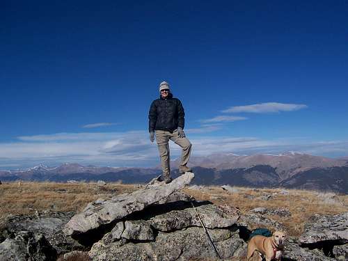 Kenosha Peak Summit
 Looking north-northwest from the summit of "Kenosha Peak" with Foster (11,871) in the foreground.
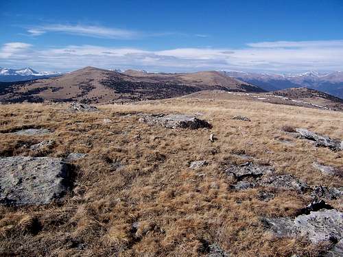 Looking northwest from the summit of "Kenosha Peak" at the trio of 12ers comprised of (from left): South Twin Cone Peak (12,265 ft.), North Twin Cone Peak (12,323 ft.) and Mount Blaine (12,303 ft.). Foster (11,871 ft.) is to the right.