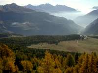
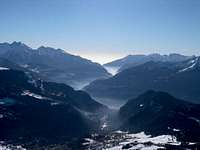
Mont Meabe is situated between the Valtournenche and the St. Barthelemy Valley, in the same chain of Cima Longhede-Becca d'Aver, north side, closer to the Cervino. It'a a very easy walk up, the summit is not too high, but the exposition of the path (south), makes it hiking very early, as there is no more snow when others paths are still covered. The view from the top is magnificient; the whole Monte Rosa Group, the Cervino, all the summits of the Valtournenche, Saint Barthélemy Valley, and the most important of the central Aosta Valley.
First ascents
First on the Summit: Unknown.
In winter: Unknown.
Getting There
From Switzerland take the Gd. St. Bernhard Tunnel to get to Aosta. Motorway A5 Torino Aosta, either from Torino or from the Mont Blanc tunnel and exit Chatillon (Valtournenche). From Chatillon take R46 to Valtournenche. At Antey St. Andrè turn left, direction Torgnon, and follow the brown sign of the pic nic area of Chantorne'; after this area, continue till a white Chapel, and park the car a few meters after, when you will find a not asphalted road on your left.
Red Tape
No rescrictions at all.
When To Climb
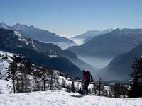
Hiking, from May to October, even November if there is no snow; ski mountaneering: the way is very steep, ask locally the conditions.
Campings
In Aosta Valley you can camp only up 2.500 meters, to hike this mountain takes only a few hours.
Mountain Conditions
Meteo: you can find all the needed informations at the official site of the Valle d'Aosta Region:
When you come back, find the time to visit a pictoresque Church and the Museum in Triatel; follow the sign Etirol left side along the road, after Torgnon.
Books and Maps
BOOKS:
"Guida della Valpelline" de l'Abbè Joseph-Marie Henry - Societè Editrice Valdotaine 1925 II Edition e Collana Reprint Musumeci (1986).
"Guida dei Monti d'Italia - Alpi Pennine" (Vol. 2) di Gino Buscaini - Club Alpino Italiano/Turing Club Italiano, Luglio 1970 (In Italian).
"Diari Alpinistici" di Osvaldo Cardellina e Indice Generale accompagnato da Schedario Relazioni Ascensioni 1964-2019 (unpublished).
Children refers to the set of objects that logically fall under a given object. For example, the
Aconcagua mountain page is a child of the 'Aconcagua Group' and the 'Seven Summits.' The
Aconcagua mountain itself has many routes, photos, and trip reports as children.
Parents refers to a larger category under which an object falls. For example, theAconcagua mountain page has the 'Aconcagua Group' and the 'Seven Summits' asparents and is a parent itself to many routes, photos, and Trip Reports.


 5914 Hits
 82.48% Score
 15 Votes