
-
 9185 Hits
-
 87.31% Score
-
 24 Votes
|
|
Mountain/Rock |
|---|---|
|
|
44.05919°N / 115.03315°W |
|
|
Custer |
|
|
Hiking, Mountaineering, Trad Climbing, Mixed, Scrambling |
|
|
Spring, Summer, Fall |
|
|
9704 ft / 2958 m |
|
|
Overview
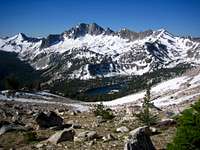
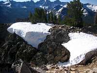
Towering just 1 mile southwest of Alpine Lake is Mount Alpen, a twin summitted peak that is mis-labeled on the USGS quad as Packrat Peak. The north side of the peak contains a permanent snowfield that is marked on the map and offers a fun snow climb for most of the year. Alpine Lake makes a great base camp, although the peak can be climbed in one day from Redfish Lake. If using Alpine Lake as a jumping off point, the Eagle's Beak, which is just northeast of Alpine Lake, along with Alpen could make for a great 2 day trip in the Sawtooths. Packrat Peak and Mt. Underhill are other nearby possibilities. The Baron Divide, just north of Alpen delineates the Sawtooth Range drainage. South of Baron Pass, waters run to Redfish Lake and then the Salmon River. North of Baron Pass, waters run to Baron Creek, South Fork of the Payette, and then the Snake River. A trail goes over the Baron Divide and is one of the most spectacular and scenic spots in the range, although mostly backpackers and trail runners will view it, as it sits a rugged 11 miles from any trailhead.
Mount Alpen's summit ridge is broad and contains exceptional views to the north of the Monte Verita area, one of the premier rock climbing areas in the Sawtooth Range. The views to the south are of the massive Elk Peak, Reward, and Mt. Underhill. Many of these peaks, including Alpen see few summit visits and complete solitude is a standard when off trail, and often when on trail. Known climbing routes on Alpen are mostly of the Class 3 snow variety, but abundant vertical rock on the north and east sides of the peak could lend itself to technical route development.
Routes
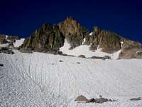
North Snow Slopes (Class 3)- the easiest way to summit starts on the west side of Alpine Lake. Weave around the rock towers and make your way west toward the permanent snow field. Climb the snow slope which is easy, but can be unnerving because the slope is so wide open. Cramp-ons and Ice-Ax may be required, but depending on the conditions, you may be able to just kick steps in approach shoes or boots. From the prominent saddle, scramble and boulder hop southeast to the summit.
Northeast Slopes (Class 3-4)- See the Routes page for more information.
Getting There
Check the road conditions at: Idaho Transportation Department

Conditions and Season
The Sawtooth Valley can be one of the coldest areas in the nation during the winter. Negative readings are common. Snowfall can vary and occur at any time. Summer days can still be hot, but you'll probably never experience 90 or above, especially once you get up higher.
Nearby Stanley, Idaho Climate Data:| Jan | Feb | Mar | Apr | May | Jun | Jul | Aug | Sep | Oct | Nov | Dec | Annual | |
| Average Max. Temperature (F) | 27.0 | 33.7 | 42.5 | 50.3 | 59.9 | 68.4 | 78.7 | 78.4 | 68.6 | 56.6 | 38.1 | 26.0 | 52.4 |
| Average Min. Temperature (F) | -0.5 | 0.3 | 9.7 | 20.3 | 28.3 | 33.9 | 36.0 | 34.0 | 27.2 | 20.6 | 12.0 | -0.8 | 18.4 |
| Average Total Precipitation (in.) | 1.64 | 1.33 | 1.02 | 1.02 | 1.17 | 1.16 | 0.59 | 0.59 | 0.78 | 0.92 | 1.46 | 1.55 | 13.24 |
| Average Total SnowFall (in.) | 16.9 | 13.2 | 10.2 | 3.4 | 0.9 | 0.2 | 0.0 | 0.0 | 0.4 | 1.7 | 10.4 | 14.6 | 71.9 |
| Average Snow Depth (in.) | 18 | 20 | 15 | 6 | 0 | 0 | 0 | 0 | 0 | 0 | 2 | 8 | 6 |

External Links
http://www.avalanche.org/~svavctr/
National Weather Service Current Forecast for Stanley:
http://newweb.wrh.noaa.gov/total_forecast/index.php?zone=idz018&county=idc037&wfo=pih&dgtl=1&lat=44.21139&lon=-114.945Sawtooth Web Cam can give you a good idea of the conditions in the area:
http://www.ruralnetwork.net/~dpinney/Sawtooth National Recreation Area
http://www.fs.fed.us/r4/sawtooth/recreation/recreport.htm
SNOTEL site gives latest snow depth readings:
http://www.wcc.nrcs.usda.gov/snotel/snotel.pl?sitenum=845&state=id