|
|
Mountain/Rock |
|---|---|
|
|
39.29140°N / 120.0317°W |
|
|
8742 ft / 2665 m |
|
|
Overview
Martis Peak is a wonderful snowshoe or cross country ski destination following a road to a fire lookout near the top. Although the mountain itself is not an impressive sight, the views from the summit are among the most spectacular of all the Tahoe Peaks, encompassing a broad swath of mountains from distant Lassen Peak to the North, nearby Castle Peak to the northwest, to the peaks surrounding Lake Tahoe. The peak offers superb views of South Lake Tahoe and the Truckee area immediately below. Although the peak can be easily hiked in a half day, it is a very nice overnight backpacking destination. This is a great place to take novices. | 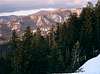 |  | 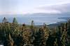 |
The Fire Lookout
Perched just below the summit is a fire lookout, originally constructed in 1914. It is staffed five days a week during the fire season for spotting fires, but it is also available during the winter for recreation. Overnight stays inside are allowed, making Martis Peak an excellent choice for backpackers who are not quite ready for a full winter backpacking experience. There is no fee to use the lookout. Inside the lookout is a small folding table and above the windows are labeled drawings to identify the surrounding peaks. It's not fancy but it is comfortable and storm-proof. I’ve never seen anyone else camping inside. Outside is a deck surrounding the perimeter of the lookout, and just below is an outhouse and picnic table. The outhouse may be difficult to enter during high snowfall. Bring a tarp to sleep on because the floor of the lookout is dirty.There are more photos of the lookout here.
General information on fire lookouts can be found here.
 |  |
The Approach and Climb
From Truckee, take Highway 267 south towards Lake Tahoe for approximately 8 miles. On the left there is a parking area next to a small drainage. A road with a gate follows the drainage. If you reach Brockway Summit on Highway 267 you have gone 0.5 mile too far.To climb Martis Peak, follow the main road from the parking area. The road will occasionally fork. Generally, when there is a major fork in the road, you will want to take the left fork (see map). Small blue diamond-shaped signs on trees mark the route. Views are obscured by the dense ponderosa pine/white fir/lodegepole pine/red fir forest until you are near the top.
The lookout is not the highpoint. To reach the high point, hike uphill (east) from the lookout for a hundred yards or so. The views from the summit are not better than the views from the lookout. The total distance round trip is 7.5 miles with a 1700 ft. elevation gain. This is a popular climb.
Snowmobilers often travel the route.
It is also possible to climb Martis Peak via the Tahoe Rim Trail.
 |
Red Tape
No permits are required. Floor space for the fire lookout is available on a first-come first served basis, although I've never seen anyone else staying there. The lookout could probably sleep 8 comfortably. No cooking or fires are allowed in the lookout. This is an historical structure.No Sno Park permit is required to park at the trailhead.
When To Climb
Anytime, although winter is probably the best time. Snowmobiles occasionally use the road.Camping
Camping is allowed in the Fire Lookout (see above).Mountain Conditions
Call the Lake Tahoe Basin Management Unit of the U.S. Forest Service at (530) 543-2600 for current conditions. Caltrans provides updated highway condition information here.Current Conditions
Forecast
hgrapid - Jun 19, 2010 5:08 pm - Hasn't voted
Directions and viewsI did Martis Peak today, and noticed that it is about 8 miles from I-80 to Martis Peak Road. Also, I am pretty sure you cannot see Round Top from Martis Peak. Otherwise, it is a good page. I suggest a slight update when you get a chance.