
-
 12966 Hits
-
 83.69% Score
-
 17 Votes
|
|
Mountain/Rock |
|---|---|
|
|
45.26400°N / 113.692°W |
|
|
Lemhi |
|
|
Hiking, Bouldering, Scrambling |
|
|
Summer, Fall |
|
|
10323 ft / 3146 m |
|
|
Overview
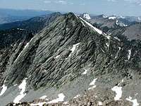
Monument Peak 10323' is one of three prominent Beaverhead Peaks that rise to the east of the Salmon skyline. It is flanked to the north by Freeman Peak and to the south by Sacajawea Peaks (known locally as the Three Sisters). Sacajawea Peaks are referred to as the North and South Doublet in Tom Lopez' book.Idaho A Climbing Guide by Tom Lopez descibes Monument as 'a rugged peak that is not easily climbed'. Considering the route description given in Lopez' book and the private land issue, that is a fair statement.
 Upper Miner Lakes
Direct access to the base of Monument Peak via Kirtley Creek road is blocked by the land owner. Additional details are provided below in the Red Tape section.
The summit rewards you with a nice contrast of vistas from the green drainages surrounding Salmon, to the dark blue jewels known as the Upper Miner Lakes, to a myriad of neighboring Beaverhead Peaks.
Getting There
 Carmen Creek Road
Take the Carmen Creek Road which is 4 miles north of Salmon on US 93. Travel 5.1 miles on this paved road. At the end of the pavement, turn right onto signed Freeman Creek Road. Travel 3 miles to a road fork.
For the southwest ridge route descibed below, take the right fork and drive a little over 1 mile to the property owners gate and fence where you can park. There are a couple of trees down in the road, but they can be driven around. This road is 2WD. To the best of my knowledge this is all public access. I saw no private property or no trespassing signs restricting travel.
For the route described in Lopez' book, take the left fork, travel 1/2 mile and cross a final cattleguard. Another 1/10 of a mile will bring you to a grassy clearing next to Freeman Creek where you can park. Any driving beyond this is 4WD.
You can find the same road directions on page 328 of Lopez' book.
Summit Routes
Southwest Ridge Class 3 Monument Peak SW ridge
This route is essentially an end run to avoid private property.
From the property owner's gate and fence, follow the barbed wire fence straight up the hillside. You are actually on Freeman Peak's southwest ridge. Continue on up through open hillside aiming for somewhere between Point 7930 and Point 8526 on Freeman's southwest ridge.
Pick your best spot to drop into the drainage and cross the North Fork of Kirtley Creek. Dropping down to this creek and then ascending on the way back is the only Class 3 section on the whole route and that is primarily due to steep terrain.
 Rock towers & summit
From the creek, gain the southwest ridge of Monument Peak and follow it all the way up to the summit. In places you can find a well worn game trail on the ridge proper. There are two rock towers on the ridge at about 10000', but they are easily avoided.
Starting elevation: 6200'
Round trip elevation gain: 5400' - 6000' (depending on route)
Round trip distance: 8.5 - 9 miles
Freeman Creek Road Class 3
This route begins at the clearing next to Freeman Creek and follows the road up. I will refer you to the route description in Lopez' book found on page 322, which is too detailed to include here.
Starting elevation: 5730'
Red Tape
 Monument Peak
Kirtley Creek Road, south of Salmon, runs right to the base of Monument Peak. However, the road does go through private property and is gated.
After talking with the BLM in Salmon, they indicated that there is no public access from the landowner and in their words 'no one ever goes up there'.
The BLM has access because if the landowner grazes cattle futher up the drainage on BLM acreage, which they all do, then the BLM has the right to cross the landowner's property.
Camping
Three miles up Freeman Creek Road, where the road forks, there is a large open area which is the closest spot. Although uneven and on a bit of a slope, it is large enough for several vehicles.In addition, there are several paved 'Recreation Areas' up and down the Salmon River where you could park overnight if you are car camping.
Summit Views
 Freeman Peak
 Sacajawea Peaks