Trail/Topo Maps
| Page Type | Gear Review |
|---|---|
| Object Title | Trail/Topo Maps |
| Manufacturer | Gem Trek |
| Page By | Dow Williams |
| Page Type | Nov 5, 2005 / Jan 27, 2007 |
| Object ID | 1471 |
| Hits | 4547 |
| Vote |
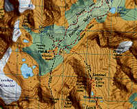
contour lines - see individual maps for contour intervals
state-of-the-art relief shading on selected maps
hiking trails - with trail names and distances marked
cross-country ski trails - shown on the Canmore & Kananaskis
hydrology- rivers, rapids and falls
mountain names, plus elevation in metres and feet
glaciers
frontcountry campgrounds
backcountry campgrounds - designated with the Parks Canada numbering system
mountain lodges
alpine huts and hostels
warden or ranger cabins
points of interest and attractions
highway viewpoints
ski areas
updated every three to four years
folded in a user-friendly way
approximately 27 x 39 in. in size, folded to 9.5 x 4.5 in.
Images
 |
Reviews
Viewing: 1-2 of 2 |

Bill Kerr - Aug 14, 2008 12:40 pm - Voted 4/5
Best hard copy maps for Canadian Rockies
Most up to date and useful hard copy maps for the Canadian Rockies.
Viewing: 1-2 of 2 |
Dow Williams - Nov 5, 2005 10:59 am - Voted 4/5
Untitled Review