


-
 3225 Hits
-
 83.69% Score
-
 17 Votes
|
|
Mountain/Rock |
|---|---|
|
|
45.84930°N / 7.09586°E |
|
|
Aosta Valley Courmayeur St. Rhémy-en-Bosses Municipalities |
|
|
Mountaineering |
|
|
Summer, Fall |
|
|
10610 ft / 3234 m |
|
|
Note
|
La montagna chiama i suoi figli, ed essi rispondono fedelmente al suo appello… Osvaldo Cardellina, Diario alpinistico, 1964-65 Page texts: @ OsvaldoCardellina "Osva", passed away on May 2, 2022. Page owners: Christian Cardellina e Osvaldo Cardellina. Any updates from September 12, 2022: Antonio Giani, page administrator, friend and climbing companion. Testi della pagina: @ OsvaldoCardellina "Osva", scomparso il 2 maggio 2022. Proprietari pagina: Christian Cardellina e Osvaldo Cardellina. Eventuali aggiornamenti dal 12 settembre 2022: Antonio Giani, amministratore della pagina, amico e compagno di salite. |
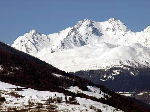
Goliath or Puddle? Overview
We continue the search for mountains that that are not well known and even less busy. Although this certainly appears to be a mountain little known and even less visited. Even the main, or the Grand Golliaz or Golliat (3.237m), of this Group does not record an excessive number of ascents, despite the lure tied to the name, perhaps the most famous in the past at the time of the Mountaineering Classic, and the relatively middle-high altitude. Then imagine for these satellites supporting actors that are certainly not comparable for example to those of Mont Blanc de Tacul. There we rock sound and compact, but here we find it somewhat broken, if not in decay. So there? Is to be not expected much for climbing, while the sense of a visit is the search for "exploratory", for those who still love it. Just from Grand Golliaz a short ridge, almost straight down linearly towards the South reaching the near Petit Golliaz, just a few feet lower (3.234m). From this last the same splits sending a branch towards South-southwest, act to separate the higher, or Northwestern, the Combe du Merdeux from Vallon of Bellecombe into the adjacent Italian Val Ferret (above Courmayeur Resort). The other branch is directed instead toward Southeast reaching the Col de Saulié (2.817m), located between the first basin and that of Thoula and to the foot of the Eastern Slope of Grand Golliaz.
Toponymically Golliaz or Golliat it not derived from Giant Goliath but by "Goglie, Gouille" or puddle of water, which is rich in the Combe of Thoula else Thoules.
Due to the fact that the median part of the valley is marked by a series of water emersion between Col St. Rhémy and the long ridge that down by Aig. de Saulié to Southeast.
Topographically speaking to note that this pyramidal mountain, collocated on the axis between South and North, is formed by three ridges with many slopes.
Two ridges disembarking in South West and South East reaching the Passes of Bellecombe and Saulié or des Ceingles (ie belt as "sengla", while the third or Northern acts as a "liaison", after the large saddle about 3.170 metres, with the nearby Grand Golliat. The whole is made up of rocks of calcium schists and brittle with very broken rotten slabs.
In Mountaineering terms to be reported as both Summit are rarely frequented, especially the Petit Golliaz that is typically achieved from the adjacent Val Ferret.
This is because the Northern Ridge with its unevenness and asperities appears more difficult than it is, but mainly because those coming from the Valley of the Great St. Bernard turns his attentions mainly to the Grand Golliat/Golliaz, albeit slightly higher but better in view looking mainly from North or Switzerland. Still on the Petit Golliaz be noted that the Ridge Southwest from Bellecombe Pass knows a good attendance, while the parallel crest or Southeast to the Col de Saulié is probably a one time been traveled.
Panoramically Photographically speaking to observe the great exposure for all ridges, while the walls-faces, as well as dangerous, are very "closed" in regard.
Great views of the Mont Blanc Chain with the Grandes Jorasses in front and up to Dolent-Tour Noir, while in the North they begin the Pennine Alps with Mont Velan and Grand Combin on the famous Great St Bernard Pass, fully visible from here. In the South they completely relax the Alps Graian from Rutor until the Monte Avìc on the valley floor.
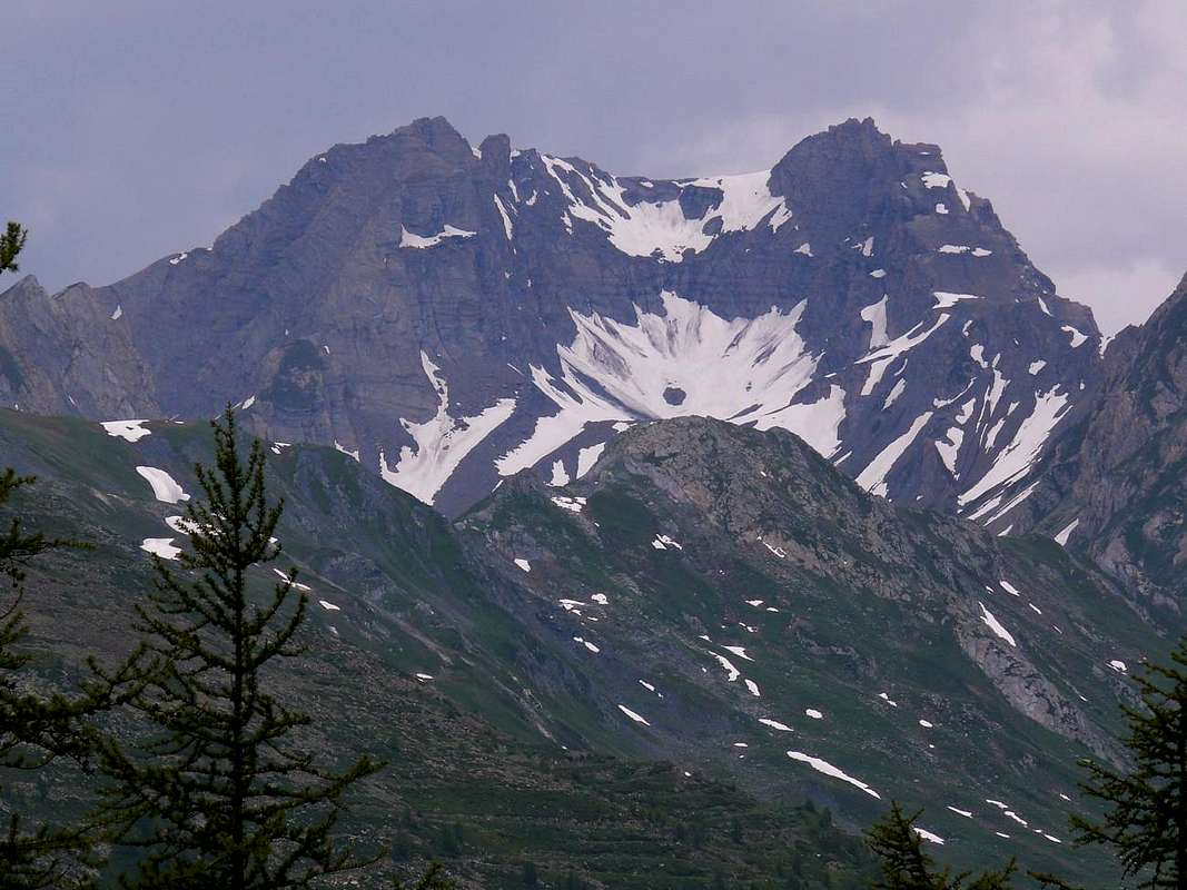
![]()
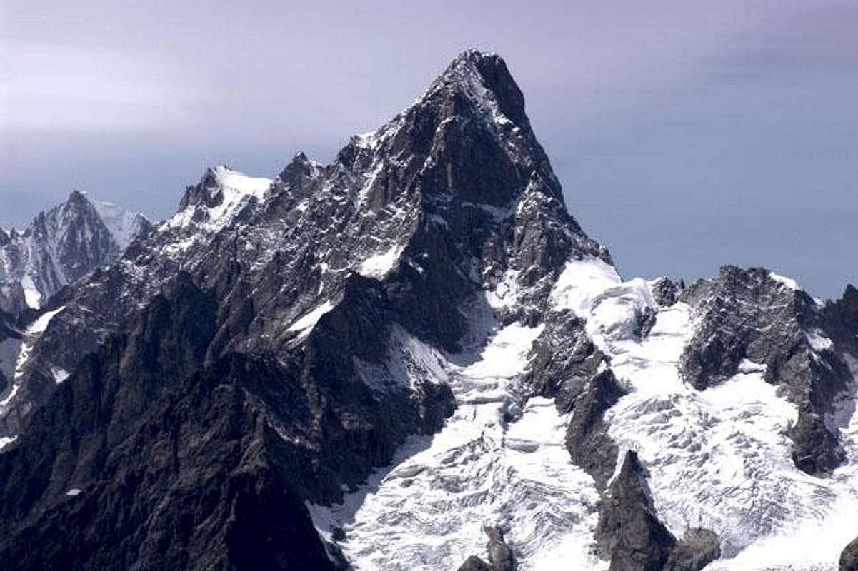
Rocky pyramid of Petit Golliaz or Golliat (3.234m) just to the left Grand Golliaz (3.237), by Osw 1996
Toponymically Golliaz or Golliat it not derived from Giant Goliath but by "Goglie, Gouille" or puddle of water, which is rich in the Combe of Thoula else Thoules.
Due to the fact that the median part of the valley is marked by a series of water emersion between Col St. Rhémy and the long ridge that down by Aig. de Saulié to Southeast.
Topographically speaking to note that this pyramidal mountain, collocated on the axis between South and North, is formed by three ridges with many slopes.
Two ridges disembarking in South West and South East reaching the Passes of Bellecombe and Saulié or des Ceingles (ie belt as "sengla", while the third or Northern acts as a "liaison", after the large saddle about 3.170 metres, with the nearby Grand Golliat. The whole is made up of rocks of calcium schists and brittle with very broken rotten slabs.
In Mountaineering terms to be reported as both Summit are rarely frequented, especially the Petit Golliaz that is typically achieved from the adjacent Val Ferret.
This is because the Northern Ridge with its unevenness and asperities appears more difficult than it is, but mainly because those coming from the Valley of the Great St. Bernard turns his attentions mainly to the Grand Golliat/Golliaz, albeit slightly higher but better in view looking mainly from North or Switzerland. Still on the Petit Golliaz be noted that the Ridge Southwest from Bellecombe Pass knows a good attendance, while the parallel crest or Southeast to the Col de Saulié is probably a one time been traveled.
Panoramically Photographically speaking to observe the great exposure for all ridges, while the walls-faces, as well as dangerous, are very "closed" in regard.
Great views of the Mont Blanc Chain with the Grandes Jorasses in front and up to Dolent-Tour Noir, while in the North they begin the Pennine Alps with Mont Velan and Grand Combin on the famous Great St Bernard Pass, fully visible from here. In the South they completely relax the Alps Graian from Rutor until the Monte Avìc on the valley floor.
Continuiamo la ricerca di montagne che non siano molto conosciute e frequentate. Anche questa sicuramente risulta esserne una poco conosciuta ed ancora meno frequentata. Anche la principale, ovvero il Grand Golliaz o Golliat (3.237 m), di questo Gruppo non registra un eccessivo numero d'ascensioni, nonostante il richiamo legato al nome, forse più famoso nel passato ai tempi dell'Alpinismo Classico, ed all'altitudine relativamente elevata. Immaginiamo quindi per questi satelliti comprimari, che non sono certamente paragonabili ad esempio a quelli del Mont Blanc de Tacul; lì abbiamo roccia sana e compatta, qui invece la troviamo alquanto rotta, se non addirittura in disfacimento. Quindi non c'é da attendersi molto per l'arrampicata, mentre il senso di una visita consiste nella ricerca "esplorativa", per coloro che ancora la amano. Proprio dal Grand Golliaz una breve cresta, quasi rettilinea, scende verso Mezzogiorno raggiungendo il vicino Petit Golliaz, di appena qualche metro più basso (3.234 m). Da questo la medesima si sdoppia inviando un ramo vero Sud-sudovest, atto a separare la parte più elevata, o Nordoccidentale, della Combe du Merdeux dal Vallone di Bellecombe internamente alla Val Ferret. L'altro ramo s'indirizza invece al Sudest raggiungendo il Col de Saulié (2.817 m), a cavallo tra la prima comba e quella di Thoula ai piedi del Versante Orientale del Grand Golliaz.
Toponomasticamente Golliaz o Golliat non deriva dal Gigante Golia bensì da "Goglie, Goullie" o pozza d'acqua, della quale é ricca la Combe de Thoula o Thoules.
Dovuto al fatto che la parte mediana della valle viene contrassegnata da emersioni d'acque tra il Colle di St. Rhémy e la lunga cresta che dall'Aig. de Saulié scende verso Sudest.
Topograficamente da annotare che questa montagna piramidale, collocata sull'asse tra Sud e Settentrione, risulta formata da tre creste con altrettanti versanti.
Due creste scendono rispettivamente a Sudovest e Sudest raggiungendo i Colli di Bellecombe e di Saulié o des Ceingles (ovvero da cintura come "sengla"), mentre la terza o Settentrionale funge da "trait d'union", dopo la larga sella 3.170 metri circa, col vicino Grand Golliaz. Il tutto risulta formato da friabili rocce calcescistiche con lastroni molto rotti.
Alpinisticamente da segnalare come entrambe sian assai raramente frequentate, soprattutto il Petit Golliaz; generalmente é raggiunto dalla Val Ferret italiana.
Questo perché la Cresta Nord con le sue asperità appare più difficile di quanto non sia, ma soprattutto perché chi proviene dalla Valle del Gran San Bernardo rivolge l'attenzione principalmente al Grand Golliaz, anche se di poco più elevato ma maggiormente in vista guardando soprattutto dalla Svizzera. Sempre a riguardo del Petit Golliaz da notarsi come la Cresta Sudovest dal Colle di Bellecombe conosca discreta frequentazione, mentre la parellela o Sudest verso il Col de Saulié probabilmente é stata percorsa in un'unica volta.
Panoramicamente e Fotograficamente da osservare la grande esposizione per ogni cresta, mentre le pareti, oltre che pericolose, son assai "chiuse" al riguardo.
Grandiose vedute sulla Catena del Monte Bianco con le Grandes Jorasses in fronte e fino al Dolent-Tour Noir, mentre a Settentrione iniziano le Alpi Pennine con Mont velan e Grand Combin sopra il famoso Colle del Gran San Bernardo, da qui pienamente visibile. A Meridione si distendono completamente le Graie dal Rutor fino all'Avìc sul fondovalle.
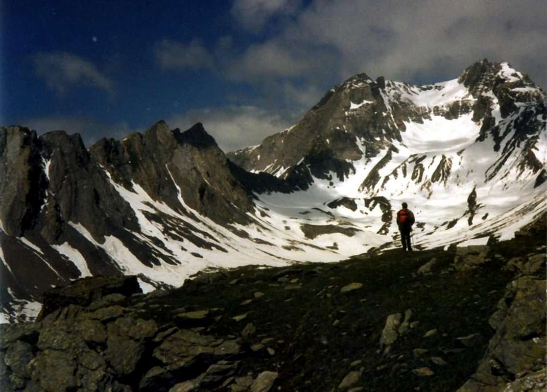
![]()
Pt. Golliaz between Grand & Aig. de Bellecombe above Thoules from SE, by Osw 2015
![]()
Ascending on Eastern sector of upper Thoules Vallon below two Golliaz, by Osw 1996
Toponomasticamente Golliaz o Golliat non deriva dal Gigante Golia bensì da "Goglie, Goullie" o pozza d'acqua, della quale é ricca la Combe de Thoula o Thoules.
Dovuto al fatto che la parte mediana della valle viene contrassegnata da emersioni d'acque tra il Colle di St. Rhémy e la lunga cresta che dall'Aig. de Saulié scende verso Sudest.
Topograficamente da annotare che questa montagna piramidale, collocata sull'asse tra Sud e Settentrione, risulta formata da tre creste con altrettanti versanti.
Due creste scendono rispettivamente a Sudovest e Sudest raggiungendo i Colli di Bellecombe e di Saulié o des Ceingles (ovvero da cintura come "sengla"), mentre la terza o Settentrionale funge da "trait d'union", dopo la larga sella 3.170 metri circa, col vicino Grand Golliaz. Il tutto risulta formato da friabili rocce calcescistiche con lastroni molto rotti.
Alpinisticamente da segnalare come entrambe sian assai raramente frequentate, soprattutto il Petit Golliaz; generalmente é raggiunto dalla Val Ferret italiana.
Questo perché la Cresta Nord con le sue asperità appare più difficile di quanto non sia, ma soprattutto perché chi proviene dalla Valle del Gran San Bernardo rivolge l'attenzione principalmente al Grand Golliaz, anche se di poco più elevato ma maggiormente in vista guardando soprattutto dalla Svizzera. Sempre a riguardo del Petit Golliaz da notarsi come la Cresta Sudovest dal Colle di Bellecombe conosca discreta frequentazione, mentre la parellela o Sudest verso il Col de Saulié probabilmente é stata percorsa in un'unica volta.
Panoramicamente e Fotograficamente da osservare la grande esposizione per ogni cresta, mentre le pareti, oltre che pericolose, son assai "chiuse" al riguardo.
Grandiose vedute sulla Catena del Monte Bianco con le Grandes Jorasses in fronte e fino al Dolent-Tour Noir, mentre a Settentrione iniziano le Alpi Pennine con Mont velan e Grand Combin sopra il famoso Colle del Gran San Bernardo, da qui pienamente visibile. A Meridione si distendono completamente le Graie dal Rutor fino all'Avìc sul fondovalle.
First Ascents
- First on Summit: unknown.
- First ascent in winter: unknown.
- Southern Wall: Gino Buscaini and Silvia Metzeltin; July 14th, 1970, in descent by Southwest Crest into the more Western Couloir towards Bellecombe Pass. In ascent: Osvaldo Cardellina and Giuseppe Lamazzi; August 04th, 1996, in ascent and in descent through the Southwest Crest.
- Southwest Crest (Normal Route from Val Ferret): Unknown.
- Western Crest: Osvaldo Cardellina, lone; June 20th, 1996, in ascent and traverse to Grand Golliaz, climbed along the Southwestern Ridge with descent through North-northwest Ridge up to the Altitude 3.082 meters and descent on West-northwest Edge of the same to Bellecombe Valley-Arnouva .
- Western Face: Osvaldo Cardellina, lone; September 19th, 1993, in descent after the traverse from Grand Golliaz, climbed through Western Wall.
- Northern Crest (standard Route by Gran St. Bernardo): Martino Baretti and Augusto Sibille; August 12th, 1881, in descent.
- Northeast Slope: unknown.
- East-northeast Face between the Top and Northern Antesummit (Couloir of Right ): Osvaldo Cardellina, Marco Cossard and Giuseppe Lamazzi; August 01th, 1982, in ascent with traverse to Grand Golliaz by Southwestern Ridge, in ascent and in descent..
- North-northeast Wall between Southeastern Antesummit and Summit: Osvaldo Cardellina and Alessandro Cardellina; July 28th, 1996, in ascent with traverse on Northeast Slope to Grand Golliaz, reaching the same from Southwestern Ridge and, on this, double descent before through the rocky Southern Couloir (to look for precipitated material) and, after with a new ascent to Top through the same gully and finally downhill again by Southwestern Crest.
- Southeast Ridge: Osvaldo Cardellina and Giuseppe Lamazzi; August 04th, 1996, in ascent and in descent again through the same.
|
|
|
Getting There
BY CAR:
- From TORINO, MILANO, etc: Motorway A5. Exit at IVREA or Quincinetto (PIEDMONT).
- From IVREA Town: before in West to Aosta, after in Northwest to Gignod, Etroubles, Saint-Oyen, Saint Rhémy en Bosses, (Southwestern and Northwestern Sides) and in North to Allein, Doues, Valpelline (Northeastern Side) Municipalities.
- From Courmayeur Resort: a) - to the Val Ferret; or b) - before in East to Aosta, after Northwest to Gignod, Etroubles, Saint-Oyen, Saint Rhémy-en-Bosses Municipalities.
- From Courmayeur-la Palud towards Planpincieux Tronchey, Lavachey Arnouva Dèsot and Bellecombe
- From Courmayeur-la Palud (1.370m), towards Montitaz (1.550m), Planpincieux (1.593m), Pont, Tronchey (1.620m), Praz Sec du Milieu (1.635m), Lavachey (1.640m), Arnouva Dèsot (1.766/9m) Villages, through Municipal Road; from this last to Bellecombe Vallon and Bellecombe Pass (2.986m).
- From Saint-Oyen or St. Rhémy-en-Bosses to Grand Saint Bernard Basin Basin up to the Saulié Pass
- From Saint-Oyen (1.377m), with previous road to Mottes, continue West-northwest to Devies Village (1.723m) at the beginning of Merdeux Comba; from this with paths through Merdeux Dèsott (1.919m), Cotes (1.930m), Manda (1.973m), Tsa de Merdeux (2.285m) Pastures to Saulié or Ceingles Hill (2.817m) by Southern Slope.
- From Saint Rhémy en Bosses Commune (1.619m), through Municipal Road, on Merdeux Comba to Tsa de Merdeux (2.285m) and Saulié Pass (2.817m) from South.
- From Saint Rhémy en Bosses Commune (1.619m) to Eastern Tula Comba to Saulié Pass (2.817m) by North-northeastern slope and Petit Golliaz (3.234m).
- From FRANCE: through the Mont Blanc Tunnel to Entrèves-crossroads to Vény/Ferret Valleys - Mountain Guides of Courmayeur - La Saxe Rock Gym - Courmayeur. By Little Saint Bernard Pass, closed since November until half May to La Thuile Valley - Pré Saint Didier - Courmayeur.
It is not necessary to take Motorway A5: you can drive on SS.26, in the direction of AOSTA - IVREA - TURIN.
BY PLANE:
- Aeroporto "Corrado Gex" Saint Christophe (Aosta).
Approaches & Routes
Route A (North Crest): this ridge connects the Petit Golliaz at the Grand Golliaz or Golliat. Formed by a linear watershed that begins from a large saddle about 3.170 meters, dates with pseudo flat way and easy route almost "walked" until you reach a square turret and yellowish (just nearby the Vertex). Climb over the tread of crest (I°+/II°/II°+) or circumvent the same to the right (West; I°/I°+) continuing on the rdge of the ridge (I°+/II°-) or avoiding the bumps in view immediately below (I°/I°+); left to the right a secondary branch, you will soon easily reach the Summit (EEA/F+; 0h'30 from the saddle; A/Pd-/F+; 0h'50 by Grand Golliaz; 2h'00/2h'15 from base; 4h'00/4h'30 from State Road). Base approach starting from Bosses Mottes Fraction (1.670m; this reachable by the road n°27 of Gran San Bernardo) towards West, descending a little to pass under the highway near the wanding bend. Ford the Rio or Torrent Artanavaz with a small bridge reaching By (1.767m), Potz-Ardusi (1.784m) and Moindaz or Muenda even Manda (1.973m) Pastures, flanking the waterfalls of Torrent of Thoules. You can arrive here also starting with the trail Alta Via n° 1 from the Devies Hamlet car parking, just beyond the winding bend, through the Pastures of Merdeux Desot (1.919m) Côtes (1.930m). From Moindaz Alp cross twice the torrent and follow the Eastern bank till the Pastures of Comba Toula and near the St. Rhémy Hill (2.540m). Follow the trail coming from it and, passing some dry scree couloirs to the West, up towards the steep moraine of the small Glacier des Bosses. Get it at 2.730/50 meters around, leaving on the left the path to Saulié Pass. On along the moraine (steep and tiring) to get the remains of the glacier; after a short and steep snowy or icy slope (36/40°) in the middle, starting from left, then to the right along a system of ledges with some sparce traces (about hundered metres; I° e II°; often ice or water on the rocky bends). Climb once at the upper debris and often snowy basin, directly towards West reaching the wide saddle above.
Departure Variants:
Departure Variants:
a) - in the lower part you can get the high Comba Thoula from the winding bend 2.079 meters of the State n°27, just beyond the Praz d'Arc Pasture along the military route to the St. Rhémy Hill (2.540m), before through muletrack then path n° 12/Alta Via n° 1.
b) - By Manda Alp in Merdeux Vallon by path not numbered.
 |
 |
 |
Via A (Cresta Nord): questa cresta collega il Petit Golliaz al Grand Golliaz o Golliat. Formata da una cresta lineare che inizia alla larga sella 3.170 metri circa, risale con percorso pseudo pianeggiante e con facile percorso pressocché "camminabile" fino a raggiungere una torretta squadrata e giallastra poco prima della Cima. Scavalcare le stessa (I°+/II°/II°+) oppure aggirare la medesima sulla destra (Ovest; I°/I°+) continuando sul filo di cresta (I°+/II°-) od evitando le asperità più in vista appena al di sotto (I°/I°+); lasciata sulla destra una diramazione secondaria, in breve si raggiunge la Vetta (EEA/F+; 0h'30 dalla sella; A/Pd-/F+; 0h'50 dal Grand Golliaz; 2h'00/2h'15 dalla base; 4h'00/4h'30 dalla Statale del Grande). L'avvicinamento di base avviene partendo dalla Frazione di Bosses Mottes (1.670 m) a sua volta raggiungibile dalla Strada Statale n°27 del Gran San Bernardo. Procedere ad Ovest scendendo leggermente a sottopassare l'autostrada al "curvone". Guadato il Rio Artanavaz su d'un ponticello, si raggiungono in progressione le Alpi di By (1.767 m), Potz-Ardusi (1.784 m) e Moindaz o Muenda ed anche Manda (1.973 m), dopo aver oltrepassato le cascate del Torrent de Thoules. Qui giunge anche il sentiero dell'Alta Via n° 1 con partenza dal parcheggio di Devies, appena oltre il "curvone", per le Alpi Merdeux Desot (1.919 m) e Côtes (1.930 m). Indi attraversare il torrente due volte per proseguire senza percorso obbligato sulla sponda Orientale arrivando ai pascoli della Comba Thoula nei pressi del Colle di St. Rhémy. Con il sentiero proveniente dal medesimo e direzione Ovest, superati alcuni solchi torrentizi asciutti, puntare alla morena frontale del minuscolo Glacier des Bosses. Raggiungerla a quota 2.730/50 metri circa, dopo aver lasciato sulla sinistra il sentiero per il Col de Sauliè o des Ceingles. Tramite percorso ripido e faticoso raggiungere i miseri resti del ghiacciaio. Alla base, dopo un ripido scivolo di neve indurita o ghiaccio (100 metri circa; 36/40°) affrontare la fascia rocciosa nel mezzo a sinistra (Sud), quindi verso destra su cenge con alcune tracce (I°+ e II°-; sovente "verglass" od acqua sulle rocce). Raggiunta la conca detritico-nevosa superiore puntare direttamente verso Ovest raggiungendo la larga sella.
Varianti di partenza:
Varianti di partenza:
a) - dalla superiore Comba Thoula, iniziando dal tornante 2.079 metri sulla Statale del Grande n° 27, appena dopo l'Alpe Praz d'Arc lungo la "militare" del Col di St. Rhèmy (2.540 m) dapprima per mezzo di mulattiera e poi sentiero n° 12/Alta Via n° 1.
b) - Dall'Alpe Manda nella Comba du Merdeux con sentiero non numerato.
![]()
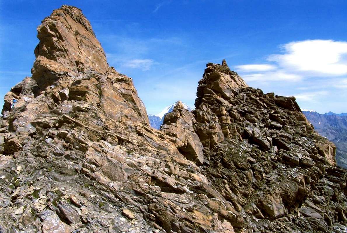
From the saddle between the two Golliaz towards the Gr. Jorasses, by emilius 2004
Route B (Southwest Ridge): certainly it appears as the surest way to this mountain starting from the parking in hearth nearby Arp Nouva Désott Alpage (1.766/9m) to the Bellecombe Pass (2.986m) in the small vallon of the same name, through the path n° 26 up to the Belle Combe Damon Alpage (2.256m; E/F; 1h'30/1h'45), then along boring and steep moraines up to the pass. The climb it is quite easy and short (242 meters) and requires not excessive capacity, although in the end some sections are quite exposed and sharp. This itinerary is also useful for the return to the same Bellecombe Pass. However, not be attracted, to make a more rapid pace, from neighboring Southern and Western Walls and Faces, because dangerously quite exposed to frequent falls of rocks and stones. The climbing on the edge of the ridge is fun (I°+/II°-), although in the descent phase should circumvent some stretch (over all in the highest part) towards West (EEA/F+; 1h'00/1h'15 from the pass; 5h'15/5h'30 by Arnouva Dèsott Alpages).
Via B (Cresta Sudovest): sicuramente risulta come la via più sicura a questa montagna con partenza dal piazzale in terra di Arp Nouva Dèsott (1.766/9 m) e raggiungimento del Col de Bellecombe (2.986 m) nell'omonimo vallone, tramite il sentiero n° 26 fino a Belle Combe Damon (2.256 m; E/F; 1h'30/1h'45) e poi tramite noiose e piuttosto ripide morene. La salita della medesima é abbastanza facile nonché breve (242 metri) e non richiede soverchie capacità, anche se nella parte terminale alcuni tratti risultano abbastanza esposti ed affilati. Questo itinerario risulta utile anche per il rientro allo stesso Colle di Bellecombe; comunque non lasciarsi attrarre, per effettuare una discesa più rapida, dalle attigue Pareti e Versanti Sud ed Ovest, perché alquanto e pericolosamente esposte alle frequenti cadute di pietre. L'arrampicata sul filo di cresta risulta divertente (I°+/II°-), anche se in fase di discesa conviene aggirare qualche tratto (soprattutto nella parte più alta) verso Ovest (EEA/F+; 1h'00/1h'15 dal colle; 5h'15/5h'30 da Arnouva Dèsott).
![]()
From the saddle about 3.170 meters towards Grand Golliaz, by emilius 2004
![]()
Traverse on ridge from Petit towards Grand Golliaz Antetop & Top, by emilius 2004
From F to F+ for the Route on the Southwestern or Northern Crests.
From PD- to PD+/AD- for the Route on Southeast Ridge.
Da F a F+ per le Vie sulle Creste Nord e Sudovest.
Da PD- a PD+/AD- per la Via sul Crestone Sudest.
For Mountaineering, but surely better if with rope and and in most helmet on the walls.
Da Alpinismo, ma certamente meglio se con corda ed inoltre casco sulle pareti.
Via B (Cresta Sudovest): sicuramente risulta come la via più sicura a questa montagna con partenza dal piazzale in terra di Arp Nouva Dèsott (1.766/9 m) e raggiungimento del Col de Bellecombe (2.986 m) nell'omonimo vallone, tramite il sentiero n° 26 fino a Belle Combe Damon (2.256 m; E/F; 1h'30/1h'45) e poi tramite noiose e piuttosto ripide morene. La salita della medesima é abbastanza facile nonché breve (242 metri) e non richiede soverchie capacità, anche se nella parte terminale alcuni tratti risultano abbastanza esposti ed affilati. Questo itinerario risulta utile anche per il rientro allo stesso Colle di Bellecombe; comunque non lasciarsi attrarre, per effettuare una discesa più rapida, dalle attigue Pareti e Versanti Sud ed Ovest, perché alquanto e pericolosamente esposte alle frequenti cadute di pietre. L'arrampicata sul filo di cresta risulta divertente (I°+/II°-), anche se in fase di discesa conviene aggirare qualche tratto (soprattutto nella parte più alta) verso Ovest (EEA/F+; 1h'00/1h'15 dal colle; 5h'15/5h'30 da Arnouva Dèsott).
Route C (Southeast Ridge): this steep ridge rises from the Col de Saulié separating the upper part of the Comba Thoula to the North by the wild Vallon des Ceingles in the South. Reach the hill through the approach of the Via A)- to the moraine at the base of the Glacier de Bosses. From this point with a detour to the South through small path n° 12, in the final part reduced to slender track and reached the collar, before the slope this steep ridge formed in the initial part by steep and not easy slabs with shale (from I°+ to III°-, discontinous route). After the same a number of gendarmes and pinnacles make the somewhat jagged ridge to reach the Eastern Antetop whence quickly to the Peak. Important during the climb, which is rather exposed on both sides, able to identify and choose the succession of the passages (A/PD/PD+/AD-; 1h'30/2h'00 by hill)
Via C (Crestone Sudest): questa ripida cresta risale dal Col de Saulié separando la parte superiore della Comba Thoula a Settentrione dal selvaggio Vallon des Ceingles a Mezzogiorno. Raggiungere il colle tramite l'avvicinamento della Via A)- fino alla morena alla base del Glacier de Bosses. Da questo punto con una deviazione verso Sud tramite sentierino n° 12, nella parte finale ridotto ad esile e poi misera traccia e raggiunto il colletto, iniziare la salita di questa ripida cresta formata nella parte iniziale da ripide e non facili placche con rocce scistose (dal I°+ al III°-, tramite percorso piuttosto disomogeneo). Dopo le medesime una serie di gendarmi rendono la cresta alquanto frastagliata (II°/II°+) fino al raggiungimento dell'Antecima Orientale, donde in breve tempo e più facilmente alla Vetta. Importante durante la salita, piuttosto esposta su d'entrambi i lati, saper individuare e scegliere collegando la successione dei brevi passaggi, quasi mai obbligati (A/PD/PD+/AD-; 1h'30/2h'00 dal colle; 5h'45/6h'15 dalle diverse partenze).
Via C (Crestone Sudest): questa ripida cresta risale dal Col de Saulié separando la parte superiore della Comba Thoula a Settentrione dal selvaggio Vallon des Ceingles a Mezzogiorno. Raggiungere il colle tramite l'avvicinamento della Via A)- fino alla morena alla base del Glacier de Bosses. Da questo punto con una deviazione verso Sud tramite sentierino n° 12, nella parte finale ridotto ad esile e poi misera traccia e raggiunto il colletto, iniziare la salita di questa ripida cresta formata nella parte iniziale da ripide e non facili placche con rocce scistose (dal I°+ al III°-, tramite percorso piuttosto disomogeneo). Dopo le medesime una serie di gendarmi rendono la cresta alquanto frastagliata (II°/II°+) fino al raggiungimento dell'Antecima Orientale, donde in breve tempo e più facilmente alla Vetta. Importante durante la salita, piuttosto esposta su d'entrambi i lati, saper individuare e scegliere collegando la successione dei brevi passaggi, quasi mai obbligati (A/PD/PD+/AD-; 1h'30/2h'00 dal colle; 5h'45/6h'15 dalle diverse partenze).
Difficulties & Equipment
From F to F+ for the Route on the Southwestern or Northern Crests.
From PD- to PD+/AD- for the Route on Southeast Ridge.
Da F a F+ per le Vie sulle Creste Nord e Sudovest.
Da PD- a PD+/AD- per la Via sul Crestone Sudest.
For Mountaineering, but surely better if with rope and and in most helmet on the walls.
Da Alpinismo, ma certamente meglio se con corda ed inoltre casco sulle pareti.
Mountain Conditions
- You can get meteo information at the official site of the Regione Valle d'Aosta:
- Valle d'Aosta Meteo
Books and Maps
- "Guida delle Alpi Occidentali", di Giovanni Bobba e Luigi Vaccarone C.A.I. Sezione di Torino Volume II (parte II), 25 Maggio 1896.
- "Guida dei Monti d'Italia-Alpi Pennine" (Vol. I°) di Gino Buscaini-Club Alpino Italiano/Turing Club Italiano, Luglio 1971 (in Italian).
- "Guida della Regione Autonoma Valle d'Aosta" di Mario Aldrovandi; Ed. S.P.E. di Carlo Fanton, Torino 1964.
- "I Rifugi della Valle d'Aosta" di Stefano Ardito, Ed. Guide iter, Febbraio 2003.
- "Diari Alpinistici" di Osvaldo Cardellina e Indice Generale accompagnato da Schedario Relazioni Ascensioni 1964-2019 (inediti).
 |
 |
 |
 |
- Kompass "Massiccio del Monte Bianco Valle d'Aosta Sentieri e Rifugi" Carta turistica 1:50.000.
- I.G.C. Istituto Geografico Centrale Torino "Massiccio del Monte Bianco" (n° 4), Torino, 1998 1:50.000.
- I.G.C. Istituto Geografico Centrale Torino "Monte Bianco-Courmayeur-Chamonix-La Thuile" (n° 107), 1:25.000.
- L’Escursionista "Monte Bianco Courmayeur" (n° 1) Edizioni Rimini 2004 1:25.000.
- L'Escursionista "Gran San Bernardo Ollomont" Ed. Rimini ( n° 5) 1: 25.000.
- Edizioni Tabacco "Mont Blanc" Udine, 1978 1:50.000.
- Studio F.M.B. Bologna 1988 "Monte Bianco-Mont Blanc" 1:50.000.
Important Information
- REGIONE AUTONOMA VALLE D'AOSTA the official site.
- FONDAZIONE MONTAGNA SICURA Villa Cameron, località Villard de la Palud n° 1 Courmayeur (AO) Tel: 39 0165 897602 - Fax: 39 0165 897647.
- Società Guide Alpine Courmayeur www.Guidecourmayeur.com - Strada Villair n° 2 - 11013 Courmayeur (Aosta) Italy - Tel. +390165842064 Fax. +390165842357 - P.I. 01022640070
- A.I.NE.VA. (Associazione Interregionale Neve e Valanghe).
Useful numbers
- Protezione Civile Valdostana località Aeroporto n° 7/A Saint Christophe (Ao) Tel. 0165-238222.
- Bollettino Meteo (weather info) Tel. 0165-44113.
- Unità Operativa di Soccorso Sanitario Tel. 118.