Overview
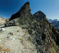
![Piz Lunghin]() Piz Lunghin seen from the north-east Piz Lunghin seen from the north-east |
is the southernmost mountain of the
Albula Alps located right above Maloja pass and thus above
Oberengadin in its north-east and
Val Bregaglia in its south-east. It is one of the lowest mountains of the group but its exposed loacation above the pass makes it a perfect lookout for the mountains around. In winter it is one of the most popular ski tours of the region, probably the only safe one to the west of St. Moritz.
In summer
Piz Lunghin usually is an afterthought to the rasther touristic hike to Lägh da Lunghin, the lake which is the source of the Inn (En) River. A number of minor creeks are collected in its basin flowing down to
Oberengadin,
Unterengadin through the
Inn Valley (passing Landeck, Innsbruck, Kufstein) towards the
Danube and later the
Black Sea. Even more curious is Pass Lunghin to the west of the lake and north-west of
Piz Lunghin, Europe's only three way watershed. While the
Inn River flows to the
Black Sea the
Maira flows to the
Adriatic Sea and the
Julier flows to the
Rhine River and the
North Sea.
There are two paths leading directly from either
Lägh da Lunghin and
Pass Lunghin to a saddle to the west of the mountain from where the south-west ridge takes you halfway up the summit block before two ledges cross back and forth through the west face. The final section is a small gully of 10m length, which can be tricky in icy conditions.
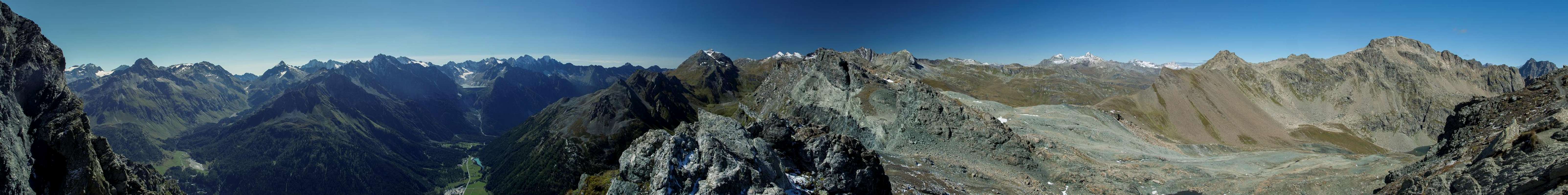
No 360° Panorama
Panorama taken some 100m beneath the summit from the south-west ridge |
Getting There
![Looking across Malojapass]() Looking across Malojapass during the descent from Piz Lunghin
Looking across Malojapass during the descent from Piz Lunghin
There are two reasonable trailheads, both close to
Maloja Pass.
Maloja is an old pass, which was already in use in Roman times which connects joins
Lombardia (Italy) and the
Graubünden (Grigioni / Grisons - Switzerland) and can be quickly reached from
Milano using the road
SS36 (Spluga) to
Chiavenna and from there SS36 to
Castasegna. Here you cross the Swiss border from where
B3 takes you to Maloja.
The starting point of the longer ski-mountaneering route is
Plaun da Lej, while the shorter hiking route is usually started at
Cadlägh. Both trailheads are on
B3 to the north-east of Maloja within 4km of each other. Another option is to park in Maloja village from where a shortcut can take you up to the hiking route as well.
Ski tour: Crossing Piz Lunghin
Starting point is
Plaun da Lej (Lake plan) from where you follow the road to
Grevasalvas (1940m), pass on its right hand side (north) climbing sweet slopes toward west.
Passing between a minor summit (on the left) and
Piz Grevasalvas (on the right) you'll get to a basin which leads you to a small pass. From here you descend toward
Lägh Lunghin. Now follow the southern shore of the lake westward until you are close to
Pass Lunghin. Right before you reach it turn left and climb more or less directly to the summit.
Best route for the descent is to ski toward NW, across
Plang Canfer until you reach the village of
Bivio (1769m). Now the only problem is to get back to Maloja .. three different way to do it :
hitch hiking ..
postal bus (if you're lucky)
or, better, starting with 2 cars, one parked at Maloja and the other one in Bivio, that can be reached using the Julier Pass road.
Summer hiking route: Lägh Lungjn, Pass Lunghin, Piz Lunghin (Pass da Sett)
The summer hike either starts in
Maloja itself or at
Cadlägh on kilometre to the north-east of it. Either way you ascend the steep slopes above
Lej da Segl with ever increasing panorama. 200m above the trailheads the two paths combine and switch back and forth until you reach a high pasture. The Inn river cascades in waterfalls above and below this pasture. Cross the pasture and in the end hike to a small pass which lies directly to the south of the lake.
From the lake several paths lead onwards. One leads directly to the south-west ridge of
Piz Lunghin, the shortest ascent to the mountain. Two others lead into the direction of
Pass Lunghin and join forces to the immediate south-east of it. Either hike to the pass and enjoy the views to the Platta Group or follow another path (blue marks) which also heads to the mountain's south-west ridge, though in a roundabout fashion. There are two saddles on the south-west ridge, the west of which offers nice deep views into
Val Bregaglia. Pass a big tower on the north side of the ridge to reach the second saddle (some exposed hiking here), follow the south-west ridge halfway up the mountain, then the two ledges through the west face. Finally climb the 10m gully to the top.
Descent: Either return the same route you came or follow the ski tour route to
Grevasalvas. You can also visit Lej Nair, another mountain lake on this route. A bold longer hike goes through
Pass Lunghin, through
Pass da Sett into
Val Bregaglia to
Casaccia. Follow the old Roman pass road back up to
Maloja.
When To Climb
![Lägh da Lunghin]() Lägh da Lunghin between Piz Grevasalvas and Piz Lunghin
Lägh da Lunghin between Piz Grevasalvas and Piz Lunghin
Winter and early spring with skis, summer and early autum on foot. Take care after snow fall: the top of the north and west faces of the mountains stay covered with snow and ice quite long and thus the final ascent gully can get precarious.
Accommodation
The resort villages in Oberengadin are quite expensive but you can fin all sorts of accommodation in the area. Follw the following link:
www.engadin.stmoritz.ch
Red Tape
![Bearded Vulture]() Bearded Vulture soaring above the summit of Piz Lunghin
Bearded Vulture soaring above the summit of Piz Lunghin
No fees no problems. Several natural parks are close so with a bit of luck you can spot bearded vultures or ibexes around the summit of
Piz Lunghin.
Weather Conditions
Maps & Books
Maps
- Oberengadin / Alta Engadina
1 : 40.000
WK 99
Kompass Verlag
ISBN: 978-3-85026-909-4
Books
- Oberengadin
Rudolf & Siegrun Weiss
Rother Verlag
ISBN: 978-3-7633-4042-2


 17387 Hits
 88.94% Score
 28 Votes
 Piz Lunghin seen from the north-east


 Looking across Malojapass during the descent from Piz Lunghin


 Lägh da Lunghin between Piz Grevasalvas and Piz Lunghin
 Bearded Vulture soaring above the summit of Piz Lunghin