
-
 7660 Hits
-
 76.66% Score
-
 7 Votes
|
|
Mountain/Rock |
|---|---|
|
|
35.21680°N / 106.493°W |
|
|
Bernalillo |
|
|
Hiking |
|
|
Spring, Summer, Fall, Winter |
|
|
7020 ft / 2140 m |
|
|
Overview
Point 7020 is a small summit located in the Rincon spur of the Sandia Mountains. It is usually overlooked due to the higher peaks in the Rincon spur: Point 8300, Rincon Peak, and Point 8201. This is a nice easy hike close to Albuquerque that offers wonderful views of the towering cliffs and rock spires of the western Sandia Mountains.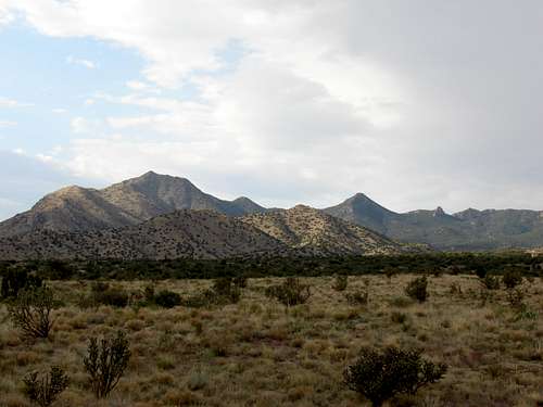 Point 7020 and the Rincon Spur
New Mexico Rank: S
Prominence: 280'
Quadrangle: Sandia Crest
Rank and Prominence information from
Lists of John
Getting There
There are two options for getting to the Trailhead depending on where in Albuquerque you are coming from:1) Go north on I-25 to exit 234 (Tramway Blvd). Drive east past Sandia Casino for approximately 3 miles to FR 333. Turn left onto FR 333 and drive for 1.3 miles. There will be a small pull-off big enough for 2 or 3 cars on the left side; this is the trailhead.
2) Go east on I-40 to exit 167 (Tramway Blvd). Follow Tramway Blvd for approximately 10 miles. When you are nearing the northern end of Tramway there will be a 3-way stop. After the stop continue until Tramway Blvd starts to turn back west. FR 333 will come up on your right. Turn right onto FR 333 and drive for 1.3 miles. There will be a small pull-off big enough for 2 or 3 cars on the left side; this is the trailhead.
Route Overviews
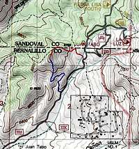 Point 7020 topo
South Ridge Trail: While this trail may be short it has a very steep finish. The trail follows an old overgrown road as it winds through a gully. Finally it brings you out onto the South Ridge of Point 7020. From here it is a straight, but steep and loose, line to the summit.
Northeast Ridge Trail: This trail is about the same distance as the South Ridge Trail but starts at a higher elevation. The trail climbs slowly until it reaches a small ridge where the climb steepens. Like the other route the rock on the upper portion is loose.
Views from the summit:
 Looking N: Point 8300
 Looking N: Point 8201
 Looking E: The Needle and North Sandia Peak
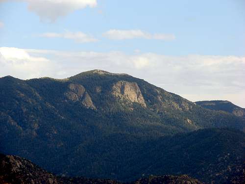 Looking SSE: South Sandia Peak
 Looking S: Tramway Blvd, the Four Hills, and the Manzano Mountains
Red Tape
Most of the parking areas off of FR 333 are fee areas and require a fee of $3 per car. The parking areas for Point 7020 are not labeled as fee areas however you should still pick up an evelop at one of the other locations and pay the $3 to ensure you do not get ticketed. Envelopes/pay stations can be found further up FR 333 at the La Luz trailhead or just off of Tramway Blvd.Camping
Point 7020 is located within Cibola National Forest so camping is allowed however there are no sites. Also, this is a very short hiking so camping should not be necessary.External Links
Local weather: AlbuquerqueLocal Search and Resuce Team: Cibola SAR
Cibola National Forest - Sandia Ranger District