
-
 11253 Hits
-
 86.85% Score
-
 23 Votes
|
|
Mountain/Rock |
|---|---|
|
|
46.65159°N / 12.56918°E |
|
|
Hiking, Scrambling, Via Ferrata |
|
|
Summer, Fall |
|
|
8494 ft / 2589 m |
|
|
Overview
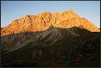
 Porze / Cima Palombino East Face Porze / Cima Palombino East Face |
The massive form of Porze, which in Italy is called Cima Palombino, dominates the western central part of the Carnic Alps Main Ridge. Seen from the north it has a castle like structure, rather wide than high, a limestone fortress rising out of the surrounding volcanic formations. Similar to the trinity of Königswand, Grosse Kinigat and Kleine Kinigat, Porze can teach you a lesson about the formation of the Alps in general and of the Carnic Alps in particular. Here, where the Italian and European tectonic plates crashed into each other rock got thrown up much like the water does when waves break on a beach producing powerful contrasts.
Porze is set back south upon a long bend of the Carnic Alps Main Ridge, which makes it an excellent lookout mountain for great parts of the ridge itself. Also, as one of the highest summits of the area you have unobstructed views to almost all sides with the nearby Sexten / Sesto Dolomites as well as the Lienz Dolomites generating most interest. To the south wave after wave, ridge after ridge of Carnic Alps mountains can be seen and far away in the east you will see Triglav, highest mountain of the Julian Alps.
 |  |  |
Porze has also been part of Europe's recent history. Like the entire Carnic Alps Main Ridge, during World War I, this was part of the front line between Austria and Italy. Heavy battles were fought here and in fact Porze was the only mountain which was conquered during the whole war. The Italians took it in 1915 but luckily for the inhabitants of the Austrian village of Obertillach 7km to the north had trouble reaching it with their artillery.
 |  |  |
The War - like in so many parts of the main ridge has left a multitude of supplying trails around the area. Many of these war trails have been maintained in the seventies; most noteworthy the 140km Karnischer Höhenweg / Traversata Carnica trekking trail on the Austrian side. Since Porze was Italian during the war the Austrian trails circle it from afar so that this is one of the few places where the trekking trail actually runs along far from the border.
  |
Two of the WW I ascent routes have been transformed into ferrate - climbing trails protected with fixed cables ladders and bolts. They both run along the ridge, one from the Porzescharte Pass in the west, the other from the Tillacher Joch Pass in the east. The latter extends far south to climb the mountain from the Italian side. A third route, also along old war trails, heads up the mountain from the south, along Cresta Palombino, the broad south ridge of Porze. It is the longest but also easiest of the hiking routes.
 |  |  |
Also, Porze is one of the mountains in the Carnic Alps Main Ridge, which is interesting to climbers. Most of the routes are loose and brittle, the direct east face route, however, is worthwhile. See the "Climbing Porze" section below.
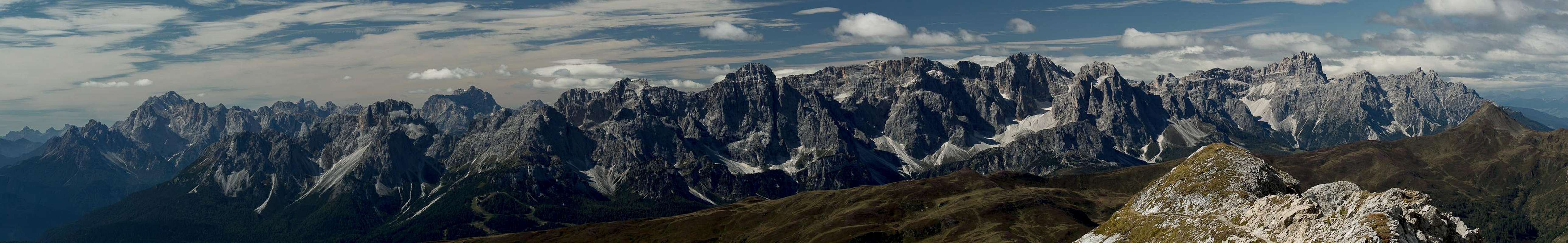
360° Summit Panorama
 |
Climbing Porze
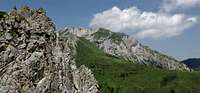
 Porze seen from Tillacher Joch
There are several routes onto Porze the two main ones ferrate, equipped with fixed cables and ladders as well as the south ridge route along Cresta Palombino (an easy hike). Most of the routes are along loose rock. None of them is rated more than UIAA IV but all are dangerous because of rockfall. Good descriptions can be found in the German Alpine Club Guidebook (German): P.Holl: Karnischer Hauptkamm, Rother Verlag, ISBN: 3-7633-1254-4. Here I will only give short abstracts.
- Western Ridge
Rated: II
First climbed: 1926 (Rudovsky, Hitzker)
- North Face
Rated: IV
First climbed: 1927 (Kaser, Steinmann)
Length: 400m
- North-eastern Ridge "Austriasteig"
Rated: III
First climbed: 1926 (Thurner)
Length: 450m
- Direct east face
Rated: IV+
First climbed: 1926 (Holl, Bieber)
Length: 400m, 13 pitches
- East face
Rated: III
First climbed: 1929 (Le Bel, Rudovsky)
Length: 300m
Getting There
 Porze seen from Spitzköfele
- Northern Trailhead at Obertillach
- From the West
- Leave the Brenner Motorway A22 near Brixen / Bressanone
- Follow SS49 to the east through Pustertal / Val Pusteria.
- To the east of Innichen / San Candido you cross the Austrian-Italian border and follow the road (now B100) to Tassenbach.
- Turn right (south-east) here onto B111, which you follow to Obertillach.
- There is a parking lot near the postal office in the centre of the village
- Leave the Brenner Motorway A22 near Brixen / Bressanone
- From the North
- Option 1: From Kitzbühel over B108 through the Felbertauern Tunnel to Lienz, then southeast to Oberdrauburg and Kötschach-Mauthen (B110), where you turn on to B111 west into Lesachtal and on to Obertillach.
- Option 2: From Salzburg along motorway A10 to Spittal. Turn west onto B100 to Oberdrauburg, there south to Kötschach-Mauthen were you turn east on B111 through Lesachtal to Obertillach.
- Option 1: From Kitzbühel over B108 through the Felbertauern Tunnel to Lienz, then southeast to Oberdrauburg and Kötschach-Mauthen (B110), where you turn on to B111 west into Lesachtal and on to Obertillach.
- From the West
- Southern trailhead near San Pietro di Cadore
- From Belluno
- Take motorway A27 to its end north of Belluno.
Go straight on SS51 to Pieve di Cadore.
Here turn right on SS51bis to Sta Caterina di Cadore.
Turn east through a tunnel to San Pietro di Cadore.
Go on for 2km, then turn north onto a side road which takes you to a parking lot at Costa d'Antola.
- A side road turns of north-west 1km before you reach Costa d'Antola. You can follow this on foot. It heads directly for Porze / Cima Palombino.
- Take motorway A27 to its end north of Belluno.
- From Belluno
Red Tape
There is no Red Tape here. However, the mountain is located on the border between Austria and Italy so have your ID ready.When To Climb
The mountain can be climbed in the usual season from June through late September. Winter ascends are possible from the south with snowshoes or tour skis.Accommodation
- Lesachtal accommodation
- Gailtal accommodation
- Hochpustertal accommodation
- Sappada accommodation
- Auronzo accommodation
Weather Conditions
Maps & Books
Maps
- Lienzer Dolomiten / Lesachtal
1:50000
Kompass Map WK47
Kompass Verlag
ISBN: 3-85491-053-3
- Sappada - S. Stefano - Forni Avoltri
1:25000
Tabacco Map 01
Editione Tabacco
Books
- Osttirol Süd
W. Mair
Rother Verlag
ISBN: 3-7633-4132-3
- Gailtal – Lesachtal – Karnischer Höhenweg
Kompass Wanderbuch 982
Kompass Verlag
ISBN: 3-85491-500-4
- Kaerntner Schitourenfuehrer
Manfred Korbaj
H. Weishaupt Verlag, Graz. 1992
- Karnischer Hauptkamm
Alpenvereinsführer
P. Holl
Rother Verlag
ISBN: 3-7633-1254-4
- ALPI CARNICHE E DOLOMITI FRIULANE
ISBN: 88-86928-37-8
- ALPI CARNICHE, vol. I - II
A. De Rovere, M. Di Gallo;
Guida dei monti d'Italia CAI-TCI; 1988
- Tirolo Orientale Sud
W. Mair
(traduzione: Barbara Schöpf / Denise Brazzioli)
Rother Verlag
ISBN: 3-7633-4307-5
- Lienzer Dolomiten / Lesachtal