
-
 5154 Hits
-
 78.27% Score
-
 9 Votes
|
|
Mountain/Rock |
|---|---|
|
|
46.66134°N / 12.63132°E |
|
|
Hiking |
|
|
Spring, Summer, Fall, Winter |
|
|
7946 ft / 2422 m |
|
|
Overview
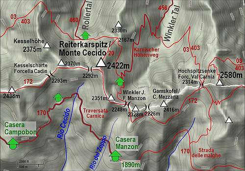
The sketch of the area

The summit
By its altitude and geographical importance Reiterkarspitz / Monte Cecido is just another small elevation in the main ridge of Carnic Alps. The neighbouring summits of similar character are Baerenbadegg / Croda Negra, 2438 m, on the west and Hochspitz / Monte Vancomun, 2580 m, on the east. Because it is built of older rocks also Reiterkarspitz / Monte Cecido is characterised by a dark appearance and grassy slopes till its top. I don't think it is worth to describe all the summits and saddled in the neighbourhood - simply see the embedded sketch.
The main Carnic Alps ridge is winding mostly in the W-E direction and in this area the same picture is repeating: a grassy summit and a flat saddle to the next summit. From the main summit long ridges are deterring towards the north, down to Lesachtal. From the Summit of Stollen / Col del Rocco, 2370 m, the ridge goes on Kesselhoehe and further on Spitzkoefele. From Reiterkarspitz / Monte Cecido a similar ridge goes on Huilahner Kogel and further on Hinterkofelegg. And so on towards the east.
On both sides of the ridge there are broad alpine pastures. The ones on the north are reached by mountain roads through the respective valleys, while those on the southern side are all connected with one panoramic mountain road - Strada delle malghe.
As seen on the sketch, the Italian and Austrian branch of the long distance hike Traversata Carnica / Karnischer Hoehenweg go each on its side of the main ridge. But on top of the ridge the marked path No. 172 goes, which is very panoramic and today mostly used by those who do the trek. In this area, the daily etappe goes from Porze Huette on the west to Hochweißstein Haus to the east. The path is very frequented, so also the summit of Reiterkarspitz / Monte Cecido is very often visited. It rises just some 5 minutes to the north of the path. By the main ridge here also the long distance Via Alpina goes - the trek which crosses the whole European Alps.
Summit Views
 Click to run online |

Towards the E
No need to stress that along the whole Carnic main ridge the views on all sides are exceptionnal. Along the ridge itself there are either kulisses of mountains following one after another, either diverse mountains, like the nearby limestone Porze / Cima Palombino. Towards the south there are the dolomitical sharp peaks of Carnic Alps, like Crode dei Longerin or Rinaldo group. Towards the north there are the nearby lower ridges of Lienz Dolomites, behind which the glaciated high peaks of Hohe Tauern are rising.
Getting There

Rollertal
See the main area pages of Carnic Alps how to get into Lesach Tal (this is the upper valley of river Gail/Zilja) where the northern approaches start and into Val Visdende where the southern approaches start. From the north, the trailheads for the main ridge paths start in the following valleys:
1. From Obertilliach. In the town deter south and drive by the valley till the altitude of 1690 m, where you park at Klapfsee. The road further on to Porze Huette is closed for public trafic.
2. From Bergen drive southwards into Rollertal.
3. From Untertilliach drive southwards into Winkler Tal.
4. Carnic trek etappe starts in Hochweißstein Haus, which is reachable through Frohn Tal. You drive from St. Lorenzen southwards till the altitude of cca 1600 m, where the road is closed for public traffic.
On the southern side of the main ridge the trailheads start in the side valleys of Val Visdende.
1. Where on 1261 m the road branches, drive left, past Locanda Alpina into Val di Londo. The road is closed on 1436 m, at Bivio Ciadon.
2. You can also drive till the eastern end of the road in Val Visdende, on 1332 m (Da Plenta hut).
Routes on Reiterkarspitz / Monte Cecido
Summer

Western approach
This section actually doesn't need much description - you simply follow the main ridge.
From the west
From Porze Huette to Tilliacher Joch / Forcella Dignas it's only 20 minutes, from the south about 2 hours. Once on the saddle, you go eastwards by the ridge and comfortably reach the summit of Baerenbadegg / Croda Negra in 1 hour, then continue eastwards and you will get on top of Reiterkarspitz / Monte Cecido in another 30 minutes. Of course you need not start the ridge crossing on Tilliacher Joch / Forcella Dignas, but you can go by the southern Traversata Carnica directly to the end of Val Cecido and then over grassy slopes on top. Or, similarly, on the northern side, you can go by Karnischer Hoehenwg on Spitzkoefele, down and ascoss the end of Roller valley and by the northern ridge on top.
From the north
You can hike either through Rollertal or Winkler Tal, and then by Karnischer Hoehenweg on the saddle in the north ridge (point 2167 m) and then by the N ridge on top.

En route
From the east
If you're coming from the east, it depends where you start. The usual day trip on Karnischer Hoehenweg starts in Hochweißstein Haus and you need to Porze Huette 8 hours 30 minutes. So, to Reiterkarspitz / Monte Cecido some more than 6 hours 30 minutes. If you start closer somewhere in the valley, it's less. There are too many options to list them all (Raabtal, Ebner Tal,...). In the near future I will post a short description of the whole daily etappe, which crosses also Reiterkarspitz / Monte Cecido.
Ski Tour
Mathias Zehring is in the Climber's Log recommending a ski tour, which comes on top by the 700 m high NE slope. It requires safe conditions!
Maps. Tabacco No. 01: Sappada - S. Stefano - Forni Avoltri. 1:25.000
Mountain Huts
- Porze Huette, 1942 m. Reachable in 45 minutes from the parking place in Obertilliacher Tal. 60 beds, opened from mid June till end September. Telefon (hut): +43/664/4038929. Telefon (valley):+43/4847/5243. Mobile: +43/664/4038929. E-mail: sport.auer@aon.at.
- Hochweißstein Haus, 1868 m. Reachable in 45 minutes from the parking place in Frohn Tal. 16+40 beds, opened from mid June till end September. Telefon: +43(4716)551, +43(0)6767462886. E-mail: hwh@aon.at.
- Boedenhuette, 2070 m. At the end of Ebner Tal.
- Mitterkarhuette, 1973 m. It's a bivouac-type hut, 4 beds. Accessible through Raabtal (valley) in 1 hour 15 minutes walk.
When to Climb?
Reiterkarspitz / Monte Cecido can be ascended any time of the season. If in winter conditions there's hard snow or even ice on the ridge, the tour requires winter equipment. Otherwise easy tour, recomended to do it when visibility is good (nice panorama).