Hochalpl / Monte Oregone

Hochalpl / Monte Oregone

Page Type Page Type: Mountain/Rock
Location Lat/Lon: 46.63000°N / 12.73000°E
Additional Information Elevation: 7822 ft / 2384 m
Sign the Climber's Log

Overview


Geographical Classification : Eastern Alps > Carnic Alps > Carnic Alps Main Ridge (West) > Hochalpl / Monte Oregone

Hochalpl photo_id=121670

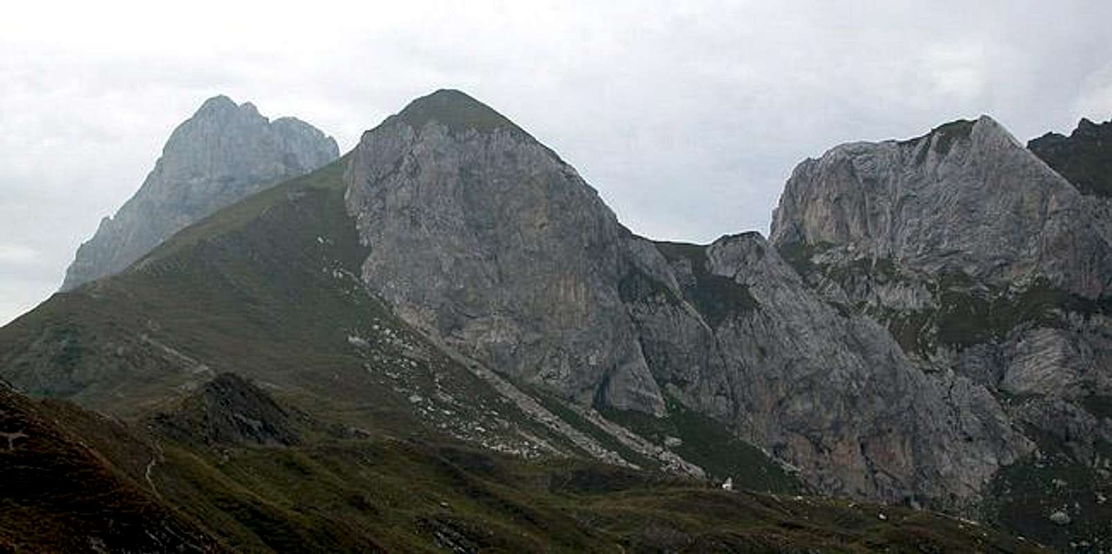
From three directions Hochalpl doesn't look like an impressive mountain. It rather seems to be a hill to the east of Hochalpl Pass, which is so easy to reach that we (gf and I ) climbed it by accident. Having been to Peralba and back and not knowing what to do we somehow found ourselves on Hochalpl, enjoying its views.

Though dwarved by the neighbouring mountains Peralba, Weissteinspitze, Raudenspitze, Chiadenis and Avanza, it is located roughly in the center of a high plateau with all these peaks at your fingertips. The views might not be far reaching but impressive nonetheless.

As you might have noticed, I left out the fourth direction in my comments of the first paragraph. For a good reason! Seen from the north-east Hochalpl shows a beautiful vertical limestone face, which is home to one of the toughest climbing routes in the whole Carnic Alps. With 250m in length and an UIAA grade of VII+ the east face seem overly impressive but the pitches are so long that from the 4th pitch upwards rapelling isn't possible anymore. Make it or break it...

The location on the high plateau between Raudenspitze, Chiadenis and Avanza was of strategical importance during World War I. Thus Hochalpl is criss-crossed by many war trenches, there are old artillery positions up there and to the west of the mountain you can find an old Italian fort of that time. You can find more information on this aspect in a trip report I wrote for the Peralba page: Along the trenches of World War I
Hochalpl photo_id=110923Hochalpl photo_id=110920Hochalpl photo_id=110919

Route Overview - Climbing Hochalpl


As said in the overview section, the north-easter part of Hochalpl shows a beautiful limestone face. There are four classical routes to be found there. Again I refer to the following (German) book for more informations: P.Holl: Karnischer Hauptkamm, Rother Verlag, ISBN: 3-7633-1254-4.
  • North-East Face
    Rated: IV
    First Climbed: 1967 (Unterluggauer, Salcher)
    Length: 120m
  • North-East Face, "Nobody"
    Rated: V+
    First Climbed: 1985 (Ortner)
    Length: 150m
  • North-East Face, "Estherhasi"
    Rated: VIII, A0,
    First Climbed: 2003 (Lugger, Winkler)
    Length: 200m
  • East Face, "Geier Sturzflug"
    Rated: VII+
    First Climbed: 1986 (Ponholzer, Ortner)
    Length: 250m
    7 long pitches, one of the toughest climbs of the Carnic Alps

Summit views


Due to the location above the high plateau between Raudenspitze and Chiadenis there are quite a number of good views to be found here.
Hochalpl photo_id=113857Hochalpl photo_id=113856Hochalpl photo_id=115383Hochalpl photo_id=121675Hochalpl photo_id=121672

Getting There


Western Main RidgeWest Central Main RidgeCrode dei LongerinPeralba - Chiadenis - AvanzaEast Central Main RidgeBiegengebirgeKellerwand - Hohe WarteMooskofel GroupRinaldo Group
Interactive map of the western part of the Carnic Alps Main Ridge. The numbers refer to the respective subgroups as given on the Carnic Alps Main Ridge (West) Page. Click on them to get the subgroup description. Hochalpl is located almost exactly where the subgroups 2, 4 and 5 meet..

I'm afraid I can only give reliable directions for the northern trailhead at Ingridhütte in Frohntal Valley. The southern trailhead is located near Sappada and I'll repeat the instructions which Marco marco979 gives on the Peralba Page at the end of this section.
  • Northern Trailhead at Ingridhütte
    Ingridhütte in Frohntal can be reached from St. Lorenzen in Lesachtal Valley. The side road is well kept only at for the first 5km. The remainder is pretty tough on any car. Lucky are those who drive a 4WD car. St. Lorenzen can be reached as follows:
    • From the West (Brenner Motorway A22)
      Leave the Brenner Motorway near Brixen / Bressanone and follow SS49 to the east through Pustertal / Val Pusteria. To the east of Innichen / San Candido you cross the Austrian-Italian border and follow the road (now B100) to Tassenbach. Turn right (south-east) here onto B111, which you follow to St. Lorenzen. There turn south into Frohntal.
    • From the North
      There are two possible roads:
      • From Kitzbühel over B108 through the Felbertauern Tunnel to Lienz, then southeast to Oberdrauburg and Kötschach-Mauthen (B110), where you turn on to B111 west into Lesachtal.
      • From Salzburg along motorway A10 to Spittal. Turn west on B100 to Oberdrauburg, there south to Kötschach-Mauthen were you turn east on B111.

  • Southern trailhead near Sappada (by marco979)
    • By car:
      From Veneto take the Venice-Belluno highway and then go towards Pieve di Cadore.
      From Friuli leave the Udine-Tarvisio highway at the Carnia Exit and drive towards Villa Santina and Forni Avoltri (45 km).
    • By train:
      Stop at Calalzo, the end of the line from Venice and Padova.
      Go to Carnia on the Udine Tarvisio line. Both train stations are about 40 kilometers from Sappada, to which they connect by frequent bus lines that meet the main trains.
    • By plane:
      The closest airports are the international airports in Venice (180 km) and Trieste (140 km).

    From Cima Sappada (a small village near Sappada, not distant from Austria) go by car or on foot along a path that follows river Piave to the sources of the river (30 minutes by car, 3 hours walking).

Red Tape


No red tape here. But wait! On the Austrian side Mountain Bikers are stopped near the trailhead at Ingridhütte. No biking there. On the Italian side we encountered motorbikers with their Trial Machines. So much for United Europe!

The mountain is located directly on the Austrian - Italian border. Though times have improved since WW I you should bring ID documents. Don't camp on the mountain, rather go to one of the two refuges (Rif. Calvi and Hochweisssteinhaus) for overnight accommodation.

When To Climb


Hochalpl can be climbed all year round. While the three climbing routes are probably too difficult in winter, the stroll to the top from Hochalpl Pass is always possible. The normal hiking season, however, is May through October.

Accommodation


There are campgrounds near the villages in the Lesachtal and Piave Valleys. For overnight stays near the mountain use the Huts (Hochweisssteinhaus and Rifugio Calvi). You can find all mountain huts and refuges in the area on the corresponding section on the Carnic Alps Page.

For hotel rooms or apartments, look at the following links:

AustriaItaly

Weather Conditions


The Carnic Alps Main Ridge serves as a weather divide between the Austrian north and the Italian south. The weather can change rapidly so that definite predictions are difficult. Look for information from both sides of the border. Head out early since the weather tends to change around noon. For weather info lookup the following sites:

Maps 'n' Books


Maps
I have been using maps by Kompass Verlag, which are very good for the hiking trails.
  • Lienzer Dolomiten / Lesachtal
    1:50000
    Kompass Map WK47
    Kompass Verlag
    ISBN: 3-85491-053-3
  • Sappada - S. Stefano - Forni Avoltri
    1:25000
    Tabacco Map 01
    Editione Tabacco

As for books please look at the corresponding section of the Carnic Alps page.


Children

Children

Children refers to the set of objects that logically fall under a given object. For example, the Aconcagua mountain page is a child of the 'Aconcagua Group' and the 'Seven Summits.' The Aconcagua mountain itself has many routes, photos, and trip reports as children.