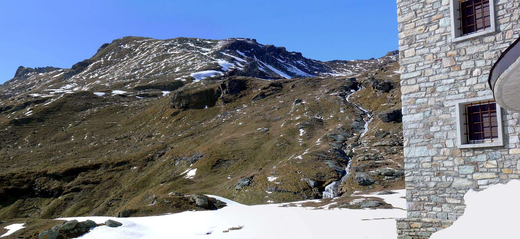
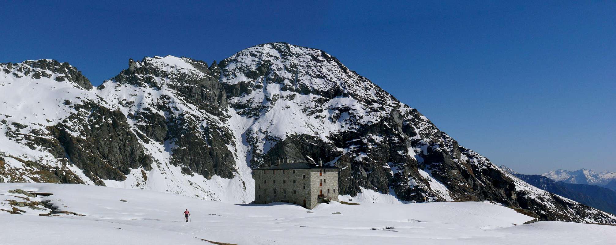
The Conca of Palasina or Palasinaz located to the West and to the North and East by the watershed ridge limited to that from Punta Valfredda also Freidòhòre down in South to the Tip Valnera and to Mont Bieteron and his great shoulder or called Mont Palòn. This, in addition to numerous pastures and alpages, also includes the Refuge de l'Arp, positioned at the base of the Western slopes Valfredda/Valnera Summits and before the three homonym small Lakes, located in their turn immediately to the North under the Hill Valfredda. Inside the same basin are located the two Palasina(z) Summits (2.740 and 2.783 meters), reached through the Soutern Slopes or by the crossing on ridge starting from the higher large saddle 2.697 meters and consequent traverse from East to the West (EE; F+; 0h’30 from the same saddle and 1h00’/1h15’ from the Arp Shelter or from Palasina Alp; 3h00’/3h30’ from Estoul Resort).
La Conca di Palasinaz situata ad Occidente ed a Settentrione e limitata ad Oriente dalla cresta spartiacque che dalla Punta di Valfredda scende a Sud alla Punta di Valnera o Valdònierhòre e fino a raggiungere il Mont Bieteron, nonché al suo spallone o Mont Palon. Essa, oltre a numerose alpi, comprende anche il nuovo Rifugio de L'Arp, posizionato alla base dei Versanti Occidentali delle Punte di Valfredda e di Valnera ed anticipante di modesta distanza i tre Laghi di Valfredda, situati a loro volta subito verso Settentrione sotto il Colle di Valfredda o Freidecoll. Internamente al medesimo bacino sono collocate le due Sommità di Palasina(z) (2.740 e 2.783 metri), raggiungibili tramite i Versanti Meridionali oppure con traversata in cresta partendo dalla più alta e larga sella 2.697 metri con conseguente scavalcamento da Oriente ad Occidente (EE; F+; 0h’30 dalla stessa sella e 1h’00/1h15’ dal Rifugio de L’Arp o dall’Alpe Palasina; 3h00’/3h30’ da Estoul).
First Ascents
First on the Summit: Unknown.
Great Traverse: (Corno Vitello-Punte Palasina or Palasinaz-Punta del Lago-Corno Bussola-Quota 2.899 metri): Osvaldo Cardellina, Roberto Stella (until Corno Bussola) and Gianfranco Vicentini (until Punta del Lago), Jul 07th, 2002.
In winter: Unknown.
Getting There
BY CAR:
From TORINO, MILANO, etc: Motorway A5. Exit at IVREA or Quincinetto (PIEDMONT).
From IVREA Town: in West (Southern side) to Pont Saint Martin, Verrès Municipalities in East from Aosta Town. From Verrès to Val d'Ayas Valley From Verrès (549m), with Regional Road, to Challant Saint Victor (765m), Challant Saint Anselme (1.060m), Brusson (1.332m) Municipalities; wanting, continuing to Northwest to Antagnod-Ayas (1.709m) Commune, below Mounts Tantané and Zerbion also in North towards Champoluc (1.570m) and Saint Jacques (1.670m) Communes at the end of Evançon or Ayas Valley and under the Western side of Monte Rosa (Rollin Hump, Breithorns, Pollux and Castor).
From Courmayeur Resort: in East-southeast to Aosta, Nus, Chatillon, Saint Vincent, Verrès Municipalities.
From FRANCE: through the Mont Blanc Tunnel to Entrèves/Courmayeur. By Little Saint Bernard Pass, closed since November until half May to La Thuile Valley - Pré Saint Didier - Aosta - Verrès Municipalities. It is not necessary to take Motorway A5: you can drive on SS.26, in the direction of AOSTA - IVREA - TURIN.
BY PLANE:
Aeroporto "Corrado Gex" Saint Christophe (Aosta).
Approach and Routes
Approach through Palasinaz Vallon: from Brusson Commune to Estoul Village (+; 1.818m; great parking; panels and variaous signals) with the Regional Road; from this, in North through dirt road concomitant with the trail n° 5, towards Fenillettaz Pastures (1.840m), following alternative (1.882m; signal no transit for unauthorized means), Fontaine (1.903m), Chanlochère (2.012m), fork 2.029 meters, Chavanne (2.107m) Alpages, alternatives 2.103, 2.209 meters nearby Litteran Lake (2.226m), fork 2.231 meters. From the latter continue on the farm dirt road that with a long diagonal followed by a few bends goes towards the above Arp Refuge (2.439m; 1h'30/2h'00).
A) - From the refuge continue towards the North with the trail n° 5A/5B passing quickly the three Freida Lakes (2.544m, 2.575m, 2.589m) up to the collar-depression 2.823 meters on the watershed. Leaving to the right the deviation with small path n° 5A for Valfredda Pass (2.807m), continue instead towards the Northwest up to the Eastern Crest (East-northeast). Along the last easy tract reach the Summit (EE/F/F+; 3h'15/3h'30 from the beginning of dirt road nearby Estoul Village).
B) - The same route but passing just Westwards reaching the Alpe di Palasina (2.406m) via a small variant on the left that reaches the Alpe 2.132 meters and then connects to the previous route (same time and same difficulties).
Avvicinamento dal Vallone: dal Villaggio di Estoul (1.818 m; grande parcheggio con pannelli con segnalazioni varie) dapprima verso Nordovest poi Nord tramite la Strada Regionale; dal villaggio, con direzione a Settentrione per mezzo della poderale concomitante al sentiero n° 5, in direzione degli Alpeggi di Fenillettaz (1.840 m), successivo bivio (1.882 m; segnale di divieto al transito per i mezzi non autorizzati), e le successive Alpi di Fontaine (1.903 m), Chanlochère (2.012 m), bivio 2.029 metri, Chavanne (2.107 m), biforcazioni (2.103, 2.209 metri) nelle vicinanze del Lago Litteran (2.226 m), seguente bivio 2.231 metri. Da quest'ultimo continuare con la strada poderale che con un lungo diagonale seguito da alcuni tornanti prosegue verso il soprastante Rifugio Arp (2.439 m; 1h'30/2h'00).
A) - Dal rifugio continuare verso Settentrione con il sentiero n° 5A/5B passando in breve tempo i tre Laghi di Freide (2.544 m, 2.575 m, 2.589 m) fino a raggiungere il colletto 2.823 metri sullo spartiacque. Lasciando a destra la deviazione con sentierucolo n° 5A per il Passo di Valfredda (2.807 m), continuare invece verso Ovest e tramite la facile Cresta Orientale (Est-nordest) fino a raggiungere la Sommità (EE/F/F+; 3h'15/3h'30 dall'inizio della poderale presso il Villaggio di Estoul).
B) - Identico percorso ma passando appena più verso Occidente raggiungendo l’Alpe di Palasina (2.406 m) tramite una piccola variante a sinistra che raggiunge l’Alpe 2.132 metri e che poi si connette al precedente itinerario (stesso tempo ed identiche difficoltà).
Gear
For Hiking or with snowshoeing also by ski.
Da Escursionismo o con racchette da neve oppure sci.
Difficulty
From F to (in winter for BSA= good skiers-mountaineers) F+.
Da F ad (in inverno per BSA o buoni sciatori-alpinisti) F+.
Parents refers to a larger category under which an object falls. For example, theAconcagua mountain page has the 'Aconcagua Group' and the 'Seven Summits' asparents and is a parent itself to many routes, photos, and Trip Reports.

 996 Hits
 82.48% Score
 15 Votes