
|
|
Mountain/Rock |
|---|---|
|
|
48.35616°N / 121.04086°W |
|
|
8261 ft / 2518 m |
|
|
Overview
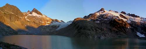
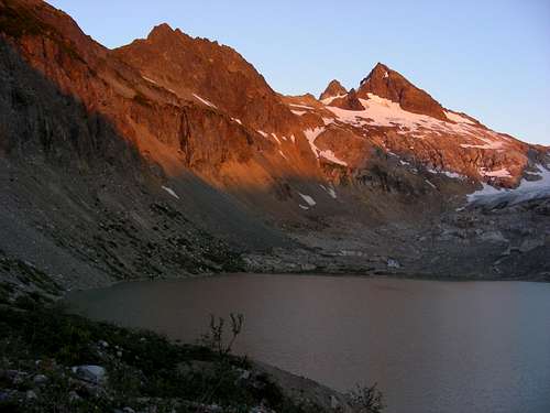
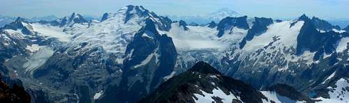
Sentinel Peak, the pyramid in the distance to the left
Sentinel (8261) is a fine highpoint in this part of the North Cascades, standing a short distance west of, and slightly taller than, Old Guard Peak. In fact, if you pay attention to such rules, Old Guard barely qualifies by the 400p rule as a separate summit. I find it curious that lower Old Guard had a page before Sentinel. Perhaps it is because Old Guard is regarded by many as the better “climb”, due to lousy rock quality on Sentinel? But such quibbles don’t really matter, do they? It’s all good out here.
Sentinel is most often climbed, probably almost exclusively climbed, by parties doing the famed Ptarmigan traverse. To describe the “approach” in this case would be to describe the Ptarmigan Traverse, so I shall refer the reader/climb planner to those well-written pages here in SP.
Being the non-conformist, I once came up to just climb Sentinel, so the approach up the South Cascade River gorge is described here for those wanting to climb just this particular summit. The Old Guard page describes other approaches to the LeConte Glacier. One advantage to the approach and climb described here is that it is completely non-technical scrambling, so the ropes and all that rock anchoring/glacier travel gear can be left at home (still need ice axe, crampons, and helmet), thus opening up this fantastic viewpoint to any skilled scrambler in the mood for another visit to the Ptarmigan traverse peaks but wanting a lighter load.
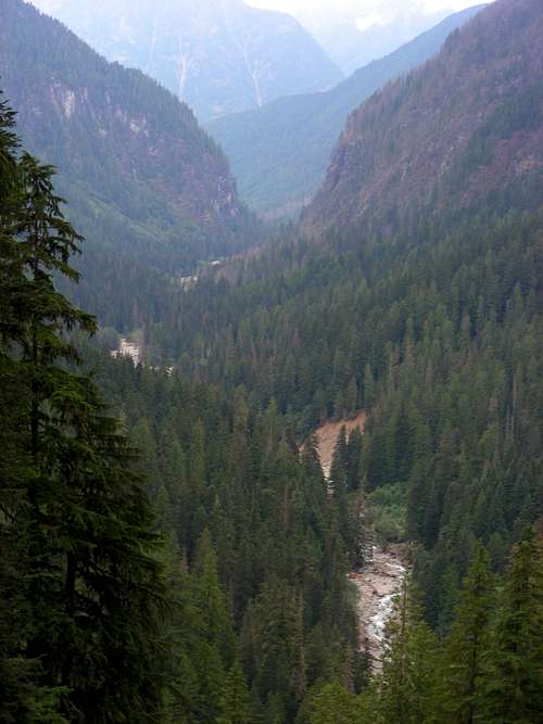
Getting There - The South Cascade River canyon
Back in the day, a strong hiker could make it up the valley/canyon to the South Cascade Lake at the foot of the massive glacier in a single day, setting one up for a reasonable 3-day weekend climb of Sentinel or a number of other peaks in the area. This access has undergone considerable deterioration over the last few years. It is now more reasonable to plan two days for the approach. Despite this, it is a spectacular valley to walk through, a display of classic North Cascades wilderness at its finest.
The South Cascade River “trail” used to have its own trailhead with a short access road. The trailhead road is now gated. It can still be walked, but is blocked in a few places by trees. To find it, drive the Cascade River Road approximately 15? (that's a guess) miles from Marblemount on Hwy 20, to the Mineral Park Campground area. Just beyond, hit the steep switchbacks. After several sharp and steep switchbacks, you will come to a hard left turn, there is a gate on the outside of this turn. You found it. Topo maps still show this road. No permit of any kind needed here, just don’t park blocking anything.
Walk the old road and within 30 or 40 minutes, hit the dead end and keep going on initially good trail. About a mile after getting on trail, find the junction with the old Middle Fork trail, also still in good shape for a while. Right after this you must cross the Middle Fork, and it ain’t easy. Logs upstream provide the precarious bridge. This is one of those log crossings that makes it tough to decide between the standing high-wire type walk or the safer sitting/sliding/straddle crossing. Beyond, the trail steadily deteriorates, becoming more challenging. The next 3+ miles are the most troublesome, feeling like 9 or 10 miles. Recent forest fires and ensuing blow-down of tons of trees and brush buried the trail. New track has been flagged and stamped out through almost the entire stretch; it is thus mostly easy to see where to go, but the going is slow due to lots of climbing over, around, under and through a woody obstacle course. In a few stretches, the ground on which the trail used to exist has been washed away by the river, forcing the traveler up and over, or more often out onto gravel bars; watch carefully for resumption of trail back into the forest as you work your way along.
The Gates
In more open areas you will see large cliffs on both sides at the beginning of the valley. I’ve nicknamed these “The Gates” as they form a sort of entryway to the lower valley (see photo). Some might add to that “The Gates of Hell” based on the difficulty of travel. There are also several intersecting watercourses to cross, a couple of which have deeply cut gorges through glacially compacted dirt and boulders; at the last and biggest one it is best to descend to the main river and then back up. But overall, the way is manageable by the determined, and still easier than a true cross-country North Cascades ‘schwack, because there is almost always trail remnants to guide the way. Make no mistake, this first part really is difficult. I’ve come to think of the gates and the 3+ miles at the beginning as a screening device to keep out the riff-raff, riff-raff being people who want their wilderness all prepared for them with easy laid-out walking paths. Or it could be just people who have more common sense than I.
After that worst 3 or 4 miles, you come to the spot labeled on USGS maps as “Box Canyon”. This is just after the deepest eroded dirt and loose-rock gorge mentioned above, requiring some work to get around, then the trail starts a bit of serious uphill. The good news is that you’ve paid the price of admission and the trail steadily improves, and in my opinion becomes the best wilderness valley-bottom hike anywhere. Partway up take a breather on the “platform”, an interesting rock table under a couple of massive douglas firs with exposed giant twisted roots, a little naturally occurring Zen garden. At the back of this platform start up talus boulders, the route flagged though obvious gaps in the brush, and then enjoy some open views as you briefly rise above the trees and leave the brush following the relatively good trail across a talus slope. Soon arrive at woods on the other side, and follow trail very steeply uphill. When this part suddenly levels out, you are on top of Box Canyon. Look around a bit, but watch your step. This side of the canyon leans out over a thousand foot drop straight into the river; I can pretty much guarantee anyone falling there will never be seen again, not even a body recovery. Continue up, following the mostly good trail – it does fade in a few brushy meadows and is buried by another clump of trees blown down – but it always re-appears if you persist. The crossing of Drop Creek is a cinch, at a pretty moss covered rock garden. There is an acceptable tent site here. High Log Creek is another story, last couple of times I was there one could cross by heading downhill and finding, well, high logs of course. These keep getting rearranged though, so might have to look around a bit.
After a demanding uphill slog through brush – the trail is still clearly there underfoot, it just requires the technique of: step, push brush away, take another step, push brush away, repeat ad nauseam – you will again enter nice forest with good trail… and then the trail vanishes at a marshy meadow. Fear not, you’re almost there!
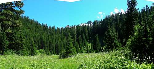
Meadow near Salix Pass
Cross the meadow due south, as you begin to ascend the grassy hillside ahead, trail will re-appear, and you will arrive at “Salix Pass” (aka Mertensia Pass from an old hiking book), right above Salix Creek. Things are opening up for good now. Below this pass is a mix of open rocky meadow, blown down smaller trees, and brush. Across the way fingers of rock tower above ice, reminding you that you are indeed still in the North Cascades. Follow trail where you can to the left – it finally eventually fades for good – I recommend continuing a slightly rising traverse to your left, using open ground where possible and woods otherwise, and eventually step out into open glacial wasteland comprised of boulders, rock and dirt. The South Cascade Glacier only recently vacated this area… very recently, like within the last hundred years, as evidenced by aerial photography from 1928 (see the link below). Once the lake and glacier start to come into view, you’ve made it. There are level benches good for camping along the north shore.
***Update, August 2016: I made another foray up this route, and was dismayed to find it has badly deteriorated. Brush has grown in thicker and the “trail” has become more obscure requiring frequent back-tracking to re-find traces of it. There are new piles of blown down trees that were not there last time I went up. When one large tree falls here, it invariably brings down half a dozen others, covering amazingly large areas in piled up logs that force long brushy detours. One of these on top of Box Canyon covers about an acre. Another right at Drop Creek looks like a bomb went off; this spot used to be dark,mossy green and shady, quite pretty, with a decent tent site, now it is open to the sky with piled up logs everywhere, dirt torn up into piles like a bulldozer went through, and the tent site is obliterated.
You’ve heard the saying “Nature abhors a vacuum”; well,apparently the North Cascades abhors a trail and immediately tries to fill in the space. The upper trail beyond High Log Creek quickly vanishes, such that I was not able to relocate it, despite having travelled up and down this route at least 8 or 9 times over the years.
Unless the Forest Service decides to put this one back on the list of official trails and applies regular maintenance, I predict that this classic old trail will completely disappear in the next few years. It is a shame. In this day and age of limited government budgets in which they will not create new trails, here is a trail for which the foundation exists, it just needs maintenance.
Route via West Face
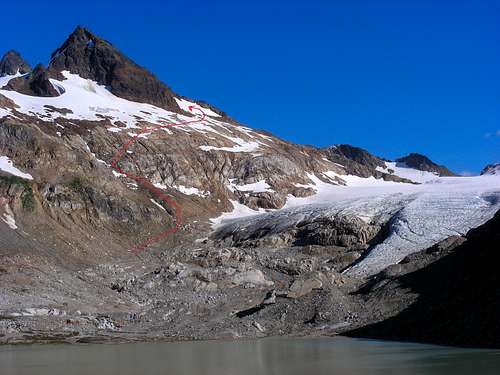
Follow red line around to the west face
The route viewed from camp
Continue the traverse along the north shore, curving around to the east shore and the foot of the glacier. Without ever setting foot on the big glacier, follow common sense upwards, easy rock scrambling leads to snow filling the basin tucked up against the west face of Sentinel. (If you are joining us from the Ptarmigan Traverse, you will naturally land at this snowfield). Climb increasingly steep snow to its highest point, then step onto the obvious ledge that slants across the face.
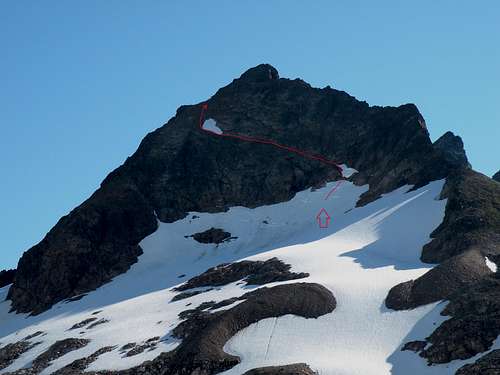
The ledge route marked in red
Follow this leftward, or north, across the face, then once past cliffs, turn straight up gravelly terrain, steep but not too difficult. There is one step approaching the top that might qualify as upper class 3 or low class 4.
What's so special about this summit?
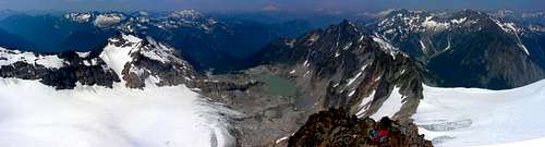
View to the north
View to the west
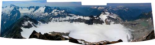
The view from Sentinel is, for me, the finest in the area, as it sits in a position wherein the major summits of the southern end of the Ptarmigan Traverse sort of snake around Sentinel in semi-circles to the north and south of this supreme viewpoint. The amazing group of peaks from Gunsight to Dome to Spire are close at hand, with the huge, curving Chikamin Glacier dropping into West Fork Agnes Creek. One of the White Rock Lakes is visible through a gap by gem-green Lizard Peak. To the north and tucked up quite close to the summits of Sentinel and Old Guard is the vast plain of ice of the upper LeConte Glacier. Further north is LeConte Mountain, and beyond are more peaks of the Traverse. Right below your feet to the west is the incredible South Cascade Glacier, big enough to set a small town upon, yet flat and smooth for most of its surface (see next section). On the other side of the giant glacier is the long ridge of Hoch Joch Spitz, and continuing in waves to the west are other great mountains of this area such as Buckindy and Snowking, and high alpine ridges connecting between them. Old Guard would have this view if Sentinel hadn’t plopped its taller self right down in front, like the rude big guy who has to take the seat right in front of you at the movies.
View to the south
Notes about the South Cascade Glacier
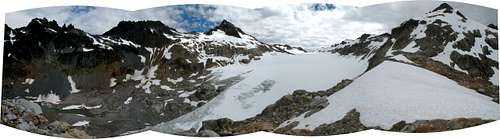
Because of its massive size and depth, the South Cascade Glacier was selected many years ago as a study model for glacier research. As a result there is lots of stuff scattered about the basin from years of setting up various monitoring stations, such as a gauging station cabin, a broken dam, and a rowboat over by the South Cascade Lake outlet. On a ridge along the west side of the glacier there is a fully equipped multi-room research station (left unlocked) with emergency gear, a marked helicopter landing pad, and even a two-way radio. Although I’ve never tried the radio, one would assume it might be a lifesaver in an emergency. One year when I was here the glaciologists were out on the glacier with a drill rig, boring ice core samples from hundreds of feet down, and flying them out via multiple helicopter visits. We probably have the continued existence of this research station to thank for the busted up trail staying somewhat alive; the trail is the researcher’s only way out when weather grounds their chopper ride, so they are probably responsible for the flagging and stomping out of something that at least resembles passable.
More about the South Cascade Glacier - link
https://www2.usgs.gov/landresources/lcs/glacierstudies/scascade.asp
Look at the photos tab to see how this glacier has shrunk!