
|
|
Mountain/Rock |
|---|---|
|
|
48.97650°N / 120.3874°W |
|
|
8274 ft / 2522 m |
|
|
Overview
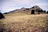
After my last page are you counting sheep yet? Well, here's one more for you to count...Sheep Mountain? Is it an apt name? Not anymore. There was a time when sheep grazed this mountain's broad, gentle slopes. But now the mountain is protected from those trodding and gobbling creatures--the mountain is in the Pasayten Wilderness. There was no doubt a time 80 years ago when you could gaze over at this mountain and see thousands of white dots strewn across its slopes.
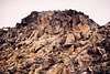
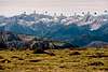
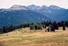
Sheep is an isolated, gentle massif in the middle of nowhere. And yet it soars high enough to stand out plainly from many vantages. Moreover, by just 34 feet the peak just manages a position on the 2,000 prominence list (at 2034P, ranking 137th out of 144). Though the peak is gentle it does possess cliffs--especially the north side where an ice remnant still clings to a high-angle slope--and a long curving wall on the southeast side rising above Sheep Lake. The summit is a large plateau perhaps the size of a baseball field. The flatness of the summit actually detracts from its stature as a viewpoint. That is, you have to walk the long rim to get views. All in all, the mountain has the feel of the Scottish Highlands, much like Ptarmigan Peak ten miles to the southwest. The entire east side drains away slowly in a lovely parkland.
Sheep Mountain is the highest point of the large uplift bounded by the East Fork Pasayten River on the west and southwest and the Ashnola River on the east. The mountain lies just 1.7 miles south of the International Border with Canada and is really most easily approached from that direction (if you can muster the guts to do an illicit border crossing).
The U.S. Coast and Geodetic Survey climbed to the summit in 1925 but this is probably not a first ascent.
Rock is primarily granodiorite and gneiss.
 |  |  |  |  |
Getting There
You can climb this mountain from a southerly direction staying completely in Washington or from the north from Canada if you feel willing to cross the border illegally. Depending on where you'll be driving from, the time spent driving to the Canada start could take just as long as the hike in from the south (but driving is always less strenuous than hiking).There is large network of trails in the Pasayten Wilderness that you could use to approach Sheep Mountain from the west, south, and east. The east-west Boundary Trail crosses Peeve Pass (6,850 ft) closely south of the summit. This trail would offer the easiest final approach to the summit but the terrain is very open (i.e., you don't really need a trail).
Washington Approaches
Two approaches stand out as the most direct: via the Billy Goat-Larch Creek Trail and via the Lake Creek Trail. Other approaches are longer and will be omitted here.Billy Goat-Larch Creek Trail
Drive 9 miles north from Winthrop on Chewuch River Road then take a left on Eightmile Road. Drive 16 more miles to the end of the road and the trailhead (c. 4,700 ft) at the corral.
At the mine adits near the trailhead be sure to take the trail on the right to 6,600-ft Billy Goat Pass (2 miles). Descend 1,000 ft into Drake Creek then up Two Bit Creek to 6,000-ft Three Fools Pass (5 miles). One mile north of Three Fools Pass go left at the trail fork and cross Diamond Creek. In 1.3 miles go right at the next fork and ascend Larch Creek (northward). In 4 more miles (8.3 miles from the car) reach 7,140-ft Larch Pass. Good camping near here? On the other side of Larch Pass continue 1.5 miles up McCall Gulch to the 7,460-ft pass at its head. Continue northward over the pass for 3 more miles (12.8 miles from the car) to 6,850-ft Peeve Pass. The summit of Sheep is an easy parkland 1.3-mile jaunt north from the pass. Expect many ups and downs on the approach trails with maybe 6,500 feet of total gain (to the summit).
Lake Creek Trail
Drive 21 miles north from Winthrop on Chewuch River Road then left up Lake Creek to the trailhead at 3,160 ft.
Hike the trail northwestward. In 4 miles pass Black Lake. In 10.5 miles reach Fawn Lake on the 6,200-ft divide between Lake Creek and Spotted Creek. The trail continues down Spotted Creek to a junction with the Ashnola River Trail in 12 miles (5,800 ft). Descend the river trail for 1.5 miles to a junction (5,480 ft) where Raven Creek comes in from the west. From here there are two final approaches to Sheep: up Raven Creek or from farther down the river.
For the continuance up Raven Creek, take the trail up that drainage to 7,152-ft Corral Lake (4.5 miles) and the pass above McCall Gulch (5.5 miles). The rest of this approach is discussed in the Billy Goat-Larch Pass Trail approach. Total distance from the car to the summit is 22 or 23 miles with an overall up-and-down gain of maybe 7,500 ft.
For the continuance down the Ashnola River, take the trail northward from Raven Creek. In 1.8 miles reach a junction with the Spanish Creek Trail. In 1.5 more miles reach the Boundary Trail coming off of Bald Mountain on the east. A short distance later is the shelter at river's edge (5,040 ft). Cross the foot bridge (a little down river from the shelter) to the west side. At 1 mile from the river cross a narrow ravine on a bridge (good water) and 0.5 miles farther reach a good camp at 5,863 ft. Here is a junction. A trail up Martina Creek is on the right. The Boundary Trail to Peeve Pass is on the left.
The trail up Martina Creek leads to a cabin. There is a way trail at 6,400 ft about a mile from the camp that loops around Sheep's north side. This was my approach to the Sheep's Northeast Ridge. It is possible to continue west up the creek to the cabin thence up open terrain to Sheep's final northeast side. A short Class 2-3 scramble gets one to the summit. Total distance from the car to the summit going this way is 21-22 miles.
The Boundary Trail continuance reaches 6,850-ft Peeve Pass in 2.8 miles but it is not necessary to go all the way there. Instead, at 2.2 miles (6,900 ft) leave the trail and angle WNW to Pt. 7491 thence to Sheep's summit. Total distance from the car to the summit goijng this way is 21-22 miles.
Canada Approaches
Note:These are approaches from Canada. I will make no comments as to the legality of crossing the International Border. Be warned that the Border Patrol is active in the Pasayten. Their main quarry are drug runners but I'm sure they'd hassle you too. Besides, you're supposed to have a permit if you're in the Pasayten Wilderness. There are no permit stations for you north of the border. But don't let the patrol worry you too much. It is a large area this wilderness.
The easiest approach to Sheep Mountain is from a logging road high on the divide north of Sheep. Canadian logging companies have denuded the land in a checkerboard grid quite close to the border. There is just such a clearcut visible quite close to Sheep. I'm not 100% positive how one would get to this clearcut but it is likely approached via Ashnola River Road (a possible road leading east along the border from the Pasayten River Valley farther west will be omitted here).
Here is the probable Ashnola River approach:
Drive Canada's Highway 3 between Princeton and Keremeos. The Ashnola River Road junctions off of the highway at 40 miles east of Princeton and 2 miles west of Keremeos. The road is not clearly marked. Distance signs on the road once you get in the valley proper are in kilometers. These are the yellow signs with black numerals attached to trees on the east side of the road.
At the 38km point (3,800 ft) there is a small pull-out on the left with a footbridge across the river (3,800 ft). This is the Wall Creek Trail used to approach Cathedral Peak. You don't want to take that trail. Continue driving south up the river. The main road will climb away from the river then make a switchback. Now heading north continue for a couple of miles to the pass west of the river. It appears there must be a logging road leading south to the aforementioned clearcut closely north of the border. I can't speak for gates on any of these roads but I know you can drive to the aforementioned pass west of the river.
A three-mile cross-country hump southward should get you to within spitting distance of the summit. The hump should not be anything more than forest and parkland travel. You definitely will want a compass. Your final approach to Sheep will probably be via its north ridge (west of Ramon Lakes).
Note: Do not make the approach from the rough road that continues south up the west side of Ashnola River. Although there is supposedly a trail here (the Centennial Trail?) it is very overgrown and is especially choked with lodgepole pine windfall. The going is very slow.
 |  |
Red Tape
A Trail Park Pass is probably required at the Billy Goat Trailhead and the Lake Creek Trailhead. At these trailheads you will be asked to fill-out a wilderness permit. The only red tape for the Canadian approach is the invisible red tape that is stretched endlessly along the International Border.When To Climb
This wouldn't be a hard mountain to ski. Getting to it in winter would be the big issue. Expect to spend two days just approaching it. Even in summer it's a long, long way if coming from the south. A climb from Canada could be done in a relatively easy day from a high logging road on the Canadian side of the border. But, depending on where you're driving from, your travels to the Canadian starting point will take several hours. The end of the Ashnola River Road takes 7 hours to get to from Seattle. To be sure the easiest time to climb Sheep would be in summer when the vast network of trails has melted out. |
Camping
Camping is plentiful in the Pasayten. There are several designated camp sites on the long approach trails. Other than those, simply camp anywhere it's flat where a water source exists.Mountain Conditions
Localized ForecastViews from the Mountain
 |  |  |  |