
-
 21544 Hits
-
 86.85% Score
-
 23 Votes
|
|
Mountain/Rock |
|---|---|
|
|
44.08570°N / 114.9799°W |
|
|
Trad Climbing, Sport Climbing, Scrambling |
|
|
7861 ft / 2396 m |
|
|
Overview
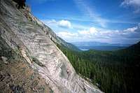
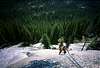
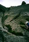
The routes range from 5.6 to 5.11 on glacially polished granite. Most of the climbing is friction climbing with some face or crack climbing moves.
| Central Gully/Regular Route-5.6 | 4+ Pitches with easy walk off to the right (east) |
| Bacon & Legs- 5.9 | 2 Pitches with older bolts. Go right at the top to join 5.6 Central Gully route |
| Catwoman- 5.10d | 1 Pitch with clips. Rappel route or walk off to the east |
| Tinman or Batman-5.10a | 1 Pitch just to the right of Catwoman with same exit; older bolts |
| Leviathan-5.10a | 2 Pitches with clips |
| Hyperspace-5.9a R | 2 Pitches + start after Leviathon- joins 5.6 route. Lack of protection |
| Scarefest- 5.11 | 1 Pitch on the leftmost (west) side of the slab |
| Guide's Belay | Practice area often used to rappel other routes |
Equipment: A full rack of nuts, cams, and runners is recommended since the condition of the fixed pro varies and if you continue to climb past 4 pitches, the climbing becomes more primitive.
Maps: USGS Mt. Cramer Quad
Excellent trip reports and pictures of this climb and many others:
 |  |  |  |  |
Getting There
Road ApproachFrom Stanley, Idaho take ID-75 south for 5 miles and turn west (right) onto the Redfish Lake Road. Take this road 2 miles to the backpacker parking lot.
Hike / Scramble Approach
Either take the Redfish Lake shuttle boat (fee), or hike 5 miles around Redfish Lake on a high lateral moraine. About 2 miles from the Redfish Boat Transfer Camp, the trail crosses a series off boardwalks there to protect the fragile moss and soft ground. Look for a faint climbers trail off to the right, just after these boardwalks. Hike 200 yards to the base of the slabs to start the climb.
 |  |
Red Tape
No permits of any kind are required. No fees or passes are required. Redfish Shuttle Boat is a seasonal service that runs from June to the end of September.When To Climb
Standard climbing season is June through October. Conditions vary greatly. The Sawtooth Valley can be one of the coldest areas in the nation during the winter. Negative readings are often common. Snowfall can vary and occur at any time. Summer days can still be hot, but you'll probably never experience 90 or above, especially once you get up higher. Nearby Stanley, Idaho Climate Data:| Jan | Feb | Mar | Apr | May | Jun | Jul | Aug | Sep | Oct | Nov | Dec | Annual | |
| Average Max. Temperature (F) | 27.0 | 33.7 | 42.5 | 50.3 | 59.9 | 68.4 | 78.7 | 78.4 | 68.6 | 56.6 | 38.1 | 26.0 | 52.4 |
| Average Min. Temperature (F) | -0.5 | 0.3 | 9.7 | 20.3 | 28.3 | 33.9 | 36.0 | 34.0 | 27.2 | 20.6 | 12.0 | -0.8 | 18.4 |
| Average Total Precipitation (in.) | 1.64 | 1.33 | 1.02 | 1.02 | 1.17 | 1.16 | 0.59 | 0.59 | 0.78 | 0.92 | 1.46 | 1.55 | 13.24 |
| Average Total SnowFall (in.) | 16.9 | 13.2 | 10.2 | 3.4 | 0.9 | 0.2 | 0.0 | 0.0 | 0.4 | 1.7 | 10.4 | 14.6 | 71.9 |
| Average Snow Depth (in.) | 18 | 20 | 15 | 6 | 0 | 0 | 0 | 0 | 0 | 0 | 2 | 8 | 6 |
Camping
Camping is allowed virtually anywhere in the regionFor more information go to the Stanley Ranger Station Site
- There are many fee-based drive-in camp sites near Redfish Lake.
- You could camp at the Redfish Inlet Transfer Camp -where the shuttle boat drops you off.
- Good bivy spots could be found along Redfish Creek.
Mountain Conditions

Latest Avalanche Report (Sawtooth Area)
http://www.avalanche.org/~svavctr/
National Weather Service Current Forecast for Stanley:
http://newweb.wrh.noaa.gov/total_forecast/index.php?wfo=pih&zone=idz018&fire=idz406&county=idc037
Sawtooth Web Cam can give you a good idea of the conditions in the area:http://www.ruralnetwork.net/~dpinney/
Sawtooth National Recreation Area
http://www.fs.fed.us/r4/sawtooth/recreation/recreport.htm
SNOTEL site gives latest snow depth readings:
http://www.wcc.nrcs.usda.gov/snotel/snotel.pl?sitenum=845&state=id