
-
 65208 Hits
-
 86.85% Score
-
 23 Votes
|
|
Area/Range |
|---|---|
|
|
Hiking, Trad Climbing, Scrambling |
|
|
Spring, Summer, Fall, Winter |
|
|
Overview
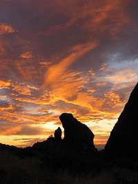
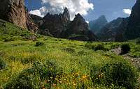
Situated 50 miles east of the Phoenix, AZ metropolitan area is one of the best hiking areas within about an hours drive of a major city. Formed by volcanic eruptions 30 to 15 million years ago, the Superstition Mountains are home to impressive rock walls, jagged hoodoos of rock, and narrow twisting canyons. The "Supes" backcountry area delineates the transition from Southern Sonora Desert to the Central Mountains. The later contains the pinyon-juniper plant types, while the former has chaparral.
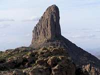
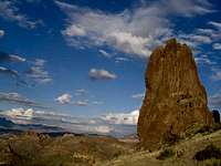
Ranging in elevation from 2000 to 6265 feet, the Superstition Wilderness Area was created in 1964 and designated 160,000 acres protected. As one of Arizona's most rugged ranges, the Superstitions offer tons of hiking from from Class 2 all the way up to technical rock climbing. Weaver's Needle is a prominent volcanic plug monolith and perhaps the best landmark for navigation. Many backcountry travelers have become lost amongst the confusing spires during the scorching heat of summer. The best hiking months are from October to March and plenty of water is needed all times of year. This is a true desert hiking area, and just because it's close to a city, doesn't mean the preparation should be any less than any other wilderness area.
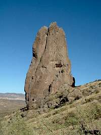
The Superstition Range contains a wealth of quality rock towers that have enormous rock climbing potential. Many of these are known in certain circles and I encourage climbers to document their favorite tower or pinnacle and attach it to this page. Covered here is just a very small portion of the most popular areas in the region. There are many more excellent jumping off points for those willing to do some exploration.
The Superstition Mountains are bounded by US-60 on the south, AZ State 88 on the northwest, and Arizona State Route 188 on the northeast.
Hiking Areas
Peralta Canyon Area- located on the south side of the range, this popular area provides access to Superstition Peak, Weaver's Needle, Miner's Trail, Miner's Needle, Peralta Canyon Trail, Cave Trail, and Bluff Spring Trail.
To get to the Peralta Canyon area, take Hwy 60 from Phoenix heading towards Globe (east) to mile post 204. Turn left on Peralta Rd. From here go about 7 miles until your at the pay station. If climbing Superstition Peak, you could park 0.6 miles before the fee area at the Carney Springs Trailhead.
Lost Dutchman Area- located on the west side of the range, this popular area provides access to Flatiron, Siphon Draw Trail, Treasure Loop Trail, and The Hand. Lost Dutchman State Park is the jumping off point for these areas. The Park is close to the wilderness area and charges a fee for entrance and parking. Restrooms, campgrounds, improved trails, and lots of people are the result of these fees.
To get to the Lost Dutchman State Park, which is located off of AZ Highway 88, drive east from Phoenix on US-60 and exit on Idaho Road. Go north on Idaho Road for 2.5 miles and turn right (follow signs for Hwy 88) toward Canyon Lake. Drive 5 miles to Lost Dutchman State Park.
Other areas include Hieroglyphic Canyon (southeast side), Fish Creek Canyon, and Tortilla Creek to name just a very few of many, many areas to explore in this range.
Check the Arizona Road Conditions
History
Around 800 A.D. many gathering and hunting Indians lived near the Superstition Mountains, followed by Hohokan villagers utilizing various agricultural practices. Up to the middle of the 1800's, the area was inhabited by Yavapai Indians and occasionally Apaches. In the late 1800's mining took place in the region as gold fever took hold here, as in many spots in the West. No great mines were established, and no great lodes discovered, but the Lost Dutchman Mine was one that was supposed to contain great riches. It was found by Jacob Waltz and Miguel Peralta and gold was supposedly taken to Globe from the Lost Dutchman Mine. Waltz died and took his secrets with him and the rest is history as treasure seekers continue to search for this lost mine.
Today, one can easily find evidence of ancient man in the form of cliff dwellings, rock art, and caves. Your encouraged by not only the law, but your own sense of decency to respect these items and leave them for future generations to explore.
Conditions and Season
The best time for hiking and climbing is from October through May, although bitter cold, torrential rain, and snowstorms can occur. Summertime temperatures are usually scorching (110 or higher) and precipitation is usually less than 3 inches for the whole summer. March is the best time for wildflower viewing.
Superstition Mountains Climate Data:
| Jan | Feb | Mar | Apr | May | Jun | Jul | Aug | Sep | Oct | Nov | Dec | Annual | |
| Average Max. Temperature (F) | 57.3 | 60.5 | 66.7 | 75.5 | 84.9 | 94.2 | 96.2 | 93.4 | 89.0 | 78.0 | 65.6 | 55.9 | 76.4 |
| Average Min. Temperature (F) | 31.0 | 33.6 | 37.9 | 43.5 | 50.7 | 58.9 | 66.4 | 65.5 | 58.5 | 48.0 | 37.7 | 30.6 | 46.9 |
| Average Total Precipitation (in.) | 1.15 | 1.50 | 1.68 | 0.59 | 0.37 | 0.30 | 1.99 | 2.85 | 1.45 | 1.38 | 1.24 | 1.38 | 15.88 |
| Average Total SnowFall (in.) | 0.2 | 1.1 | 0.0 | 0.0 | 0.0 | 0.0 | 0.0 | 0.0 | 0.0 | 0.0 | 0.0 | 0.5 | 1.9 |
| Average Snow Depth (in.) | 0 | 0 | 0 | 0 | 0 | 0 | 0 | 0 | 0 | 0 | 0 | 0 | 0 |
Links

The Legend of the Lost Dutchman Mine
Haunted Arizona: Lost Dutchman Mine
hgrapid - Feb 8, 2018 6:36 pm - Hasn't voted
Weather on pageSean, After moving to Scottsdale and hiking in the Superstitions, I am not sure Globe is a good measure of weather in the Superstitions. It's a lot higher than the Superstitions, beside the main ridge. A better weather comparison might be Superior, Apache Junction, or Gold Canyon. The Superstitions get a lot hotter than Globe.
Humphrey - Dec 14, 2023 8:35 am - Hasn't voted
Re: Weather on pageDepends on what you think of for the range, which is a lot higher in the less visited and less thought of eastern side, and where Globe is representative.