
|
|
Mountain/Rock |
|---|---|
|
|
46.92903°N / 12.10320°E |
|
|
Hiking |
|
|
Summer, Fall |
|
|
8087 ft / 2465 m |
|
|
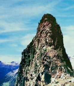
Good things come in small packages
and going after the big guns of theRieserfernergruppe/Vedrette di Ries.
Tristennockl/MonteGovoni is mostly regarded the backyard mountain of the Kasseler hutte, and nothing more.
Actually it is the highest area in entire Eastern Alps where Swiss Pine grows,
some trees growing very close to the Tristennockl´s summit(2465m/8085f)
And those are the higest Swiss pines of the entire Eastern Alps.
Subnote: The Swiss Pine (Pinus cembra) is proud member of the white pine group,
and one of most widespread pine species overall (could be found in no less then 8 european countries,
largest number of it in Hohe Tauern, Oetzal Alps and Seetaler Alps in Austria,
Oberengadin and Wallis in Switzerland). In most areas it is protected plant, in some it is not.
For example, in Austrian Stiria (Steiermark) they make 33,5 % strong brandy out of it...
Summiting:
Meagre 189m/619.2f of elevation gain, it takes only 45 minutes or so
from the Kasseler Hutte/Rifugio Roma (2276m/7465f)
in high Reintal/Val di Riva valley.
It is fairly nice and easy ascend
Pass the nice emerald green pond, and catch the trail up the Tristenockl´s crest.
Parts of the trail are secured with iron ropes (bit rusty at time of visit).
Views are nice, approach is scenic because of forementioned pond.
And because of Swiss pines not only it does look good,
but it smells good as well.
Getting There
From north, drive from Insnsbruck over the Brenner pass and further via Sterzing/Vipitena, direction Bozen/Bolzano.
Takeoff at Brixen/Bressanone and continue for Bruneck/Brunico.
From south, drive for Bozen/Bolzano and further via Klausen/Chiusa, direction Bozen/Bolzano.
Takeoff at Brixen/Bressanone and continue for Bruneck/Brunico.
From east, drive from Lienz via Tobiach/Dobbiaco till Bruneck/Brunico.
From Bruneck/Brunico hit north into Gais-Uttenheim valley, 13km till Muhlen/Molini, from there folow the signs
for Sand in Taufers/Campo Tures (its only 2km from Muhlen/Molini). From Sand in Taufers/Campo Tures, 10km drive
till Rein in Taufers/Riva Tures.
Rein in Taufers/Riva Tures is 340 souls village in high Reintal/Val di Riva valley, 10 km drive from Sand in Taufers
Getting to Kasseler hutte:
Kasseler hutte is 2 and 1/2 hours walk from Rein in Taufers/Riva Tures (1598m/5241f),
hour and half or so from the parking lot at Saege, further down the Val del Rio valley.
Catch marked trail no.8 from the parking lot at Saege (some kind of hunters lodge there) in Bachertal/Val del Rio.
Its walk-up from there.
Huts, Maps, Red Tape

As mentioned above, it is a backyard mountain of the
Kasseler Hutte/Hochgallhutte/Rifugio Roma (three names for the same building)
phone: 0039 0474 672550
open March 10th - May 5th, then again June 15th - October 10th
capacity 70 people (45 beds, 25 bunks)
Maps: Tabacco no.6 Val Pusteria/Pustertal Monti della valle Aurina/Ahrntaler berge 1:50000 scale
Red tape: You are inside Parco Regionale Vedrette di Ries-Aurina/Naturpark Reisenferner gruppe-Ahrntaler
Environment friendly behavior usual for nature parks recommended.
Gear, Weather
Gear: Sturdy boots, wind protection, map
Weather: Large clickable meteo map from Italian meteo service
Webcam