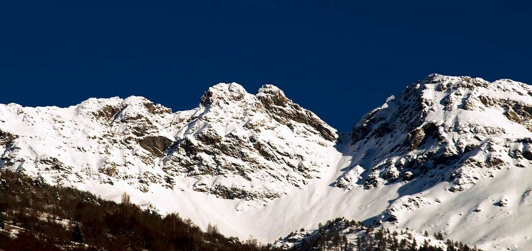
From Central Dora Valley it looks like a grim tower with a twin summit, that dominate the central axis of the River Dora Baltea between the City of Aosta and the Towns of Quart and Saint Christophe, while on the other side it should be noted Valpelline on the stretch of mountain range between the Viou Becca and the Becca Conge, forming important topographic node with its Eastern Summit between these two mountains the first of which quite known and popular, while the second, at the Col Saint Barthélemy, has characteristics diametrically conflicting. Even "our" mountain turns out to be poorly attended, perhaps due to its "surly" by an analysis from below, as well as for the length of the approach. But the devil is less bad than you think! The Eastern Top, from various on-site analysis, turns out to be the highest, (2.974/5 meters around), despite the claims of the formal and official Cartography and the lack of literature on existing, is easier; however, requires the ability to interpret the way through a small assemblage, moreover logical. While the Western Summit exposes a few problems, at least in search of the route and even more so in winter with frozen snow on the slopes and in the presence of "verglass phenomena", especially in the final stretch. With regard to the etymology of this strange, so as to appear prefino exotic name there is to observe how it has been interpreted differently over time by sudiosi and researchers in different eras. So by "Chatalaizena" of the "Charter of the United States of Sardinian" is passed to the "Chatelaizena" by Adams-Reilly of the "Charter" of 1865, the "Kantelezaina" of the Abbé Amé Gorret, "The Bear of the Mountain", with Claude-Nicolas Bich in the "Guide de la Vallée d'Aoste" of 1876, the "Kantalaizena" by Italian Military Geographic Institute (I.G.M.) of 1885, "M. Tsaat al'estena" still by IGM in 1927 to vary in scale 1:100.000 again, and with a dispute between Brocherel and Sticca in 1939. The Aosta Valley Historian Julius Brocherel stated in the C.A.I. Monthly Magazine 1939 page 86: "the funny logowriting is the result of a misspelling perpetrated by the detector card Sardinian ... " correcting to "Tsanté-leino", that is not hard to top. In this interpretation by te Researcher Joseph Sticca, always RM 1939 page 536, contrasts, strengthened also by the explanation in "Dictionnaire du patois valdotain" by the Abbot Jean Baptiste Cerlogne with a "Tsantè-Leisen", meaning "summit unoccupied" that is still a virgin and therefore do not climb on anyone. We're getting married this interpretation, as already said Gino Buscaini in "Pennine Alps Volume II" on pages 571/3 in the "Guide of the Mountains of Italy" C.A.I./T.C.I, 1970: "... since the two peaks for the inhabitants of the past centuries, they could really seem inaccessible ..." To the Abbot Jean-Marie Henry instead it credit for, in addition to being the first climber of the two peaks in 1912 and 1923, have christened the narrow neck between the two, calling to the "Col de Tsaat a l'etsena", that the letter in Italian means "hot in the back". Never crossed, was reached for the first time since the roped Quendoz-Jorrioz in summer 1972. The first winter of the two peaks are dated 1974 and 1985, by mountaineers from Aosta both starting from the Village of Avisod in the Hamlet of Trois Villes. From the summits a wonderful 360° view upon the whole Val d'Aosta alpine range, the Dora Baltea Central Valley, the far Piedmont Region and the huge swiss and french mountains.
Appare dalla Valle Centrale della Dora qual arcigna torre dalla cuspide gemellare, tale da dominare l'asse centrale del Fiume Dora Baltea tra la Città di Aosta ed i Comuni di Saint Christophe e Quart, mentre sul versante opposto si evidenzia sulla Valpelline nel tratto di catena montuosa tra la Becca di Viou e la Becca Conge, costituendo importante nodo topografico con la sua Sommità Orientale tra queste due montagne la prima delle quali alquanto nota e frequentata, mentre la seconda, presso il Colle di Saint Barthélemy, presenta caratteristiche diametralmente contrastanti. Anche la "nostra" risulta esser montagna scarsamente frequentata, fors'anche per il suo aspetto "imbronciato" da un analisi dal basso, oltreché a causa della lunghezza dell'avvicinamento. Ma il diavolo é meno brutto di quanto si pensi! La Cima Orientale, da varie analisi in loco, risulta la più elevata, (2.974/5 metri circa), nonostante quanto conclamato dalla Cartografia formale ed ufficiale e dalla scarsa letteratura al merito, é più facile; richiede però la capacità di interpretare la via tramite un piccolo concatenamento, peraltro logico. Mentre quella Occidentale qualche piccolo problema lo espone, almeno nella ricerca della via ed ancora di più in inverno con i pendii gelati ed in presenza di "verglass", soprattutto nel tratto finale. Per quanto concerne l'etimologia di questo strano, tanto da apparire prefino esotico, toponimo vi é da osservare come sia stato diversamente interpretato nel tempo da parte di sudiosi e ricercatori in epoche diverse. Così dal "Chatalaizena" della "Carta degli Stati Sardi" si é passati al "Chatelaizena" della "Carta Adams-Reilly" del 1865, al "Kantelezaina" dell'Abbé Amé Gorret, "L'Ours de la Montagne", con Claude-Nicolas Bich nella Guide de la Vallée d'Aoste del 1876, al "Kantalaizena" dell'Istituto Geografico Militare Italiano (I.G.M.) del 1885, "M. Tsaat al'estena" ancora da parte dell'I.G.M nel 1927 in Scala 1:100.000 per variare ancora, e con una disputa, tra il Brocherel e lo Sticca nel 1939. Lo Storico valdostano Giulio Brocherel affermava in Rivista Mensile del C.A.I. 1939 in pagina 86: "Il divertente logogrifo é il risultato di un errore d'ortografia perpetrato dal rilevatore della carta sarda ... " correggendo in "Tsanté-leino", ovvero sommità non difficile. A questa interpretazione il Ricercatore Giuseppe Sticca, sempre in RM 1939 in pagina 536, si contrappone, forte anche della spiegazione in "Dictionnaire du patois valdotain" dell'Abbé Jean Baptiste Cerlogne, con un "Tsantè-leisen", cioè "sommità non occupata", ovvero ancora vergine e quindi non salita da nessuno. Noi sposiamo questa interpretazione, come già esternò Gino Buscaini in "Alpi Pennine Volume II" alle pagine 571/3 nella "Guida dei Monti d'Italia" C.A.I./T.C.I., 1970: " ... dato che le due punte, per i valligiani dei secoli scorsi, potevano davvero sembrare inaccessibili ... " All'Abate Jean-Maria Henry spetta invece il merito di, oltre ad essere stato il primo salitore delle due vette nel 1912 e nel 1923, di avere battezzato lo stretto colletto tra le due, chiamandolo "Col de Tsaat a l'etsena", che alla lettera in italiano significa "caldo alla schiena". Mai attraversato, é stato raggiunto per la prima volta dalla cordata Quendoz-Jorrioz nell'estate del 1972. Le prime ascensioni invernali alle due distinte sommità portano invece la data del 1974 e del 1985, da parte di alpinisti aostani entrambe con partenza dal Villaggio di Avisod nella Frazione di Trois Villes. Dalle due vette si gode di una splendida vista a 360° sulla cerchia alpina valdostana, sulla Valle Centrale della Dora Baltea, sul lontano Piemonte e sui colossi franco-elvetici.
TOPOGRAPHY TOPONYMY and HISTORICAL REMARKS
BUTTRESS BECCA of VIOU - MONT MARY-TETE of ARPISSON-PUNTA of SENEVE'-TSAAT a l'ETSENA-BECCHI of FANA. Notes of Topography, of Toponymy and Historians It notices Important: this monograph is to intend as completion and complementarity, thanks to the numerous one man shows ""juvenile scorribande or raids "mostly, of the and to the jobs of the Abbé Henry "Guide of the Valpelline", 1925 and of Gino Buscaini "Alps Pennine Vol. II°", 1971, such to remain always as fundamental and fundamental works, as well as surely profits to wake up again the desire of search from the young people in an unknown sector of mountains not to say neglected to the more.
***
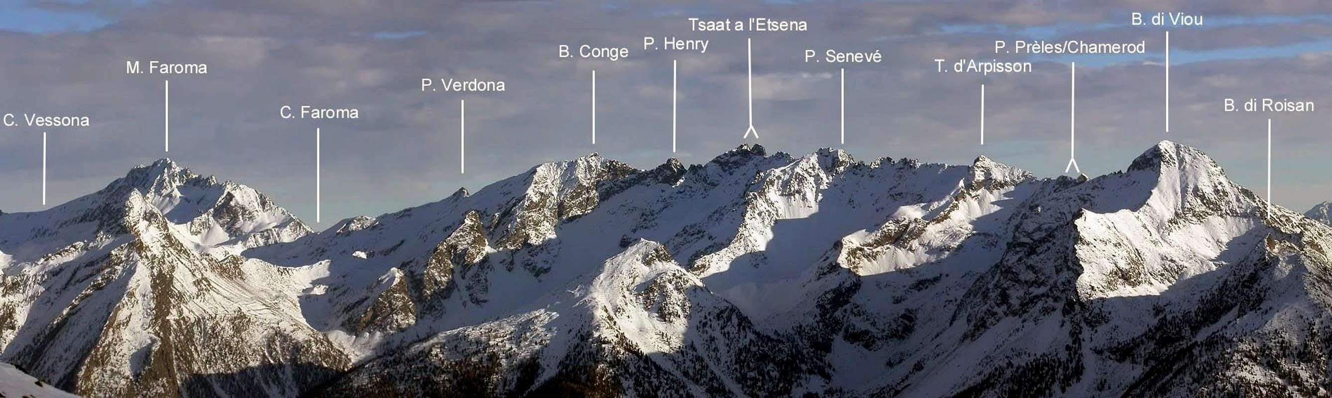
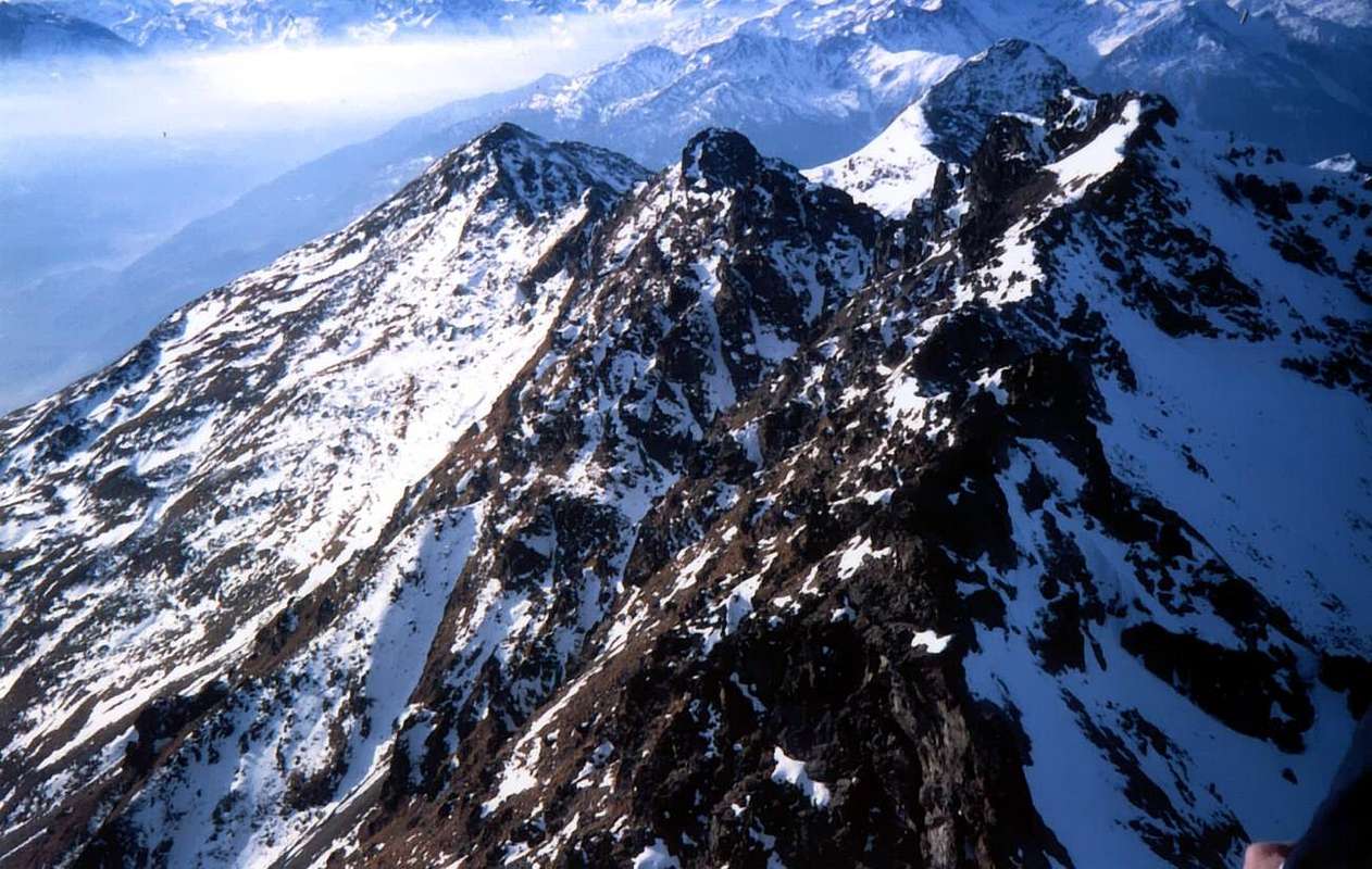
This beautiful and double pyramid raises him on the mountainous chain, fit to separate the Valpelline, to North, from the Central Valley of the River Dora Midday Baltea, summit the tallest on this line of crest, that form up to the Beaks of Fana, with relative Crest South-southeast that declines up to the Cross of Fana, a great fauteil (= armchair) above the Communes of Roisan, Aosta, Saint Christophe and Quart in the median part of the Central Valley of Stream Dora Baltea. The same coastline, exclusively rocky, it begins with the lower case letter Becca of Roisan also called Becca di Pechenville(2.546m), in SP, above the Communes of Valpelline (960m) Northwestern and of West Roisan (866m). After a large Saddle2.482m (he could have called Pass of Roisan allowing through the transit a steep and small rocky Couloir in diagonal East/west on the impending stony ground the ruins of the ancient Alpe Baraques (2.383m) in Valpelline; surely in old times crossed already used from hunters or from shepherds of mountain in transit among the Comba of Valfreyde in Valpelline and the Alps of Viou, as well as the Village of Blavy) reaching successively a secondary quota or Becca of Blavy(2.508m), also ex Quota 2.494 meters in I.G.M. The same, it raises again him to most imposing Becca of Viou (2.856m; Antonio page in dated Feb 20th, 2002 always in SP), more known peak surely and frequented of the whole small dominant subgroup the City of Aosta. In this line, and to the base to the quota 2.561m of the Crest West-northwest of the Viou, another exists, but well smaller and double separated from a small rocky protuberance, saddle that as Hill of Blavy could be suitable (2.495/2.500 meters around) the Western "Depression" and 2.520/5 meters about the small Eastern Inclinated Saddle, both easily attainable from South; while on the opposite side or to Northern introduces a brief and enough binding wall of about thirty meters. He can be used, more than for the crossing, to begin the slope of the aforesaid crest, that however from the in general Valpelline he is mostly reached usually in an elevated point, or around the 2.730/50 meters about. From the Pecks come down to the homonym and main point Pass (2.696/8m), next to which from little time the has been positioned Bivacco Penne Nere-I Camp out Black Pens (2.730m; the sole into whole small Subgroup), near a rocky and jagged appendix that falls then to North above the Lake of Arpisson(2.482m), the unique in the whole little Mountain Chain, known as the Mont Tre(a)mbloz (2.735 meters around), the crest watershed raises again him in the corpulent Mont Mary(2.815m); already essay in SP also called Mont Saint Joseph, that dominates the Communes of Saint Christophe and Quart, and it continues toward Northeast forming a whole series of small points and little towers amongst various collars, for the truth a little useful to the transit and in practice few or not frequented entirely, as of however the points themselves formed not by tiresome rocks to the sight by the lower part with good and friable rock and mixed to rather dangerous grassy lines. For this whole line of crest, that from the Becca of Roisan it reaches the Mont Mary, climbing over the Becca of Viou and transiting through the homonym Hill, sends to the already existing and detailed analysis already effected in relative and posted pages in SP. Surely it is to observe as this line of crest watershed, at least as it regards the liaison Becca of Viou-Mont Mary, it results to be the more frequented of the whole chain both for the facility of slope of these two tops, both because the intermediary Hill of Viou is destination of easy passage, sure as well as very frequented between the Comba of Blavy and the Valpelline, so much is of it that goes up again a path Inter Valleys initialed with the n° 102 from the Commune of Roisan that it goes down toward the Walloon of Arpisson. As it regards the Mont Mary, to underline as can constitute a beautiful trip of ski-mountaineering departing from the small Village of Chamerod and, through the Comba of Senevé, gone up again of his Slope Southeast; also the trip with snowshoes up to the Alpage of Senevé is pleasant and profitable rather with splendid sights on the before GROUP of the Emilius Mountain. This part of crest is known from the mountain climber and of the excursionists, while the crest watershed that proceeds toward East, and of which will speak later immediately, it poorly results you frequent I know much that the ascensions be counted on the point of the fingers of the hands; it is turned to adventurous spirits that love to go out from the runs usually frequented and from the resonant names; it gives dark and however emotions and nowhere to be found loneliness in mountain. And all this a stonesthrow from the city!
Then, successively of Mount Mary, with Southwestern direction before to East towards the Saint Barthélemy Pass and after Northeastern and from Fana Becchi finally to Southeast reaching the Fana Croix, the progressive order of which it is the following: Chaudière Southwestern Pass (2.735 meters around) also of Mount Mary Pass; small saddle debris between the Northeast Crest of Mount Mary and the Point of Chamerod; of elementary access on the South Slope for small rocks and end deposit, goes down steep toward North above the Lake of Arpisson(2.482m) and it is not of utility for the crossing among the Basin of Senevé and the "Vallone" of Arpisson, being to prefer the Hill Northeast, really also him a little frequented, if not from isolated and sporadic hunters. Point of Chamerod (2.750/2 meters around); she takes the name from the underlying place formed by some restructured constructions, up to the beginnings of the seventies constituted from old rascard (= construction in wood suspended through some small pillars on a plinth in stone; you see photo) among which a very beautiful and meaningful. Information had on the spot from shepherd of the zone in 1971; not rated on some paper, manual or books denominates of it. It constitutes the natural prolongation of the Crest East-northeast of the Mont Mary, exactly in the point in which this fold mostly to East; on the Slope Northwest goes down with a brief, yellowish and almost vertical wall on the Walloon of the Arpisson in Valpelline. Slope (for the first time?) by Osvaldo Cardellina and Marco Périer March 30 th 1969 in crossed from the Becca of Viou and return to the same one; also climbed in winter Feb 23 th, 1975 from Osvaldo Cardellina, Marco Cossard and Giuseppe Lamazzi in an ascension without ski and not even snow rackets, with departure from the Village of Blavy (1.475m) and crossing in crest to the Mont Mary and the Point of Chamerod, identical return and prolongation up to the Becca of Viou. Chamerod Carving(2.740/2 meters about); he takes the name from the homonym point a small breach resulting between the same one and the Point Western de Les Prèles. Of easy entered by South, introduces a tiresome slope to Northern, for which thing the transit is unadvisable and surely not easy, since it develops him in a small wall of 150 meters around wedged among the two rocky ribs coming from the homonym point and from that of the Prèles; it is formed from broken and enough steep rocks and exposed to the fall of stones. Point of the Prèles or Preyes also Preilles (2.747/8 meters around the small and forked Western Summit and 2.750/1 meters around that more serrated Oriental); immediately in East of the preceding pass and of Chamerod Point, it is formed from a series of small a little evident summits with smooth rocks, but you fracture and of easy slope from South. Same considerations that for the Point of Chamerod. Slope (for the first time?) from Osvaldo Cardellina and Saverio Cusumano Sep 03 th, 1971, in crossed by the Mont Mary and return to the same and subsequent one crossed to Becca of Viou. Les Prèles Carving(2.738/40 meters about); he takes the name from the homonym points a little breach resulting between the two Points Western and Eastern of Les Prèles; of easy entered by South, introduces a tiresome slope to Northern, for which thing the transit is unadvisable, so the precedent carving, but the difficulties of the run are binding and dangerous even more with impending steep rocks some tongues of residual snow. Chaudière Northeast Pass (2.746m in the "Excursionist Map Conca di Aosta Pila - Monte Emilius n°4"; 2.680 meters around), in "Alps Pennine" Vol. II"°, pag. 578, by Gino Buscaini; 1970); more marked carving on the crest watershed allows the passage between the Central Valley of the Dora Baltea and the Valpelline Valley to Noerthern. Surely the simplest and less dangerous passage, after the well most known and frequented Hill of Viou, along the whole chain among the two places, formed by both the sides from deposits with soil and stony grounds and "clapeys"(= great boulders in dialect of Aosta Valley) with grassy lines in the median and basal lines. Situated at basic of the Crest Southwest of the Tête d'Arpisson used and for the first winter slope of this last in 1975, the considerations macaws worth done for the homologous Hill Southwest also Mary Pass.
Tête of Arpisson also called from the inhabitants Pelon de Quart(2.856/7m about); he is constituted by to small pyramid with three crests: two along the axle Southwest/Northeast on the ridge watershed, while the third, always rocky, goes down toward North-northwest above the Pass of Fouillou(2.437m). Slope for the first one turned alone by the Abbé Joseph Maria Henry August 19 th, 1905; the first winter has been effected Mar 02 th, 1975 in crossed by the Point of Chamerod-Point of Les Prèles - With the Chaudière Northeastern and ending for the Crest Southwest, by Osvaldo Cardellina, Marco Cossard and Giuseppe Lamazzi, with departure from the Alp of Chamerod (1.614/5m). In descent the same run in opposite sense. Already essay in SP in date Jan 93th, 2008. Saddle of Arpisson(2.865 meters around); wide and long Saddle between the Tête of Arpisson and the Quota 2.888 meters around, the maximum depression of which it is more neighbor to this last; of untrustworthy access for the a lot of existing grass on the rocks of the South Slope, also from North introduces a slope of broken rocks and deposits. Unadvisable on both the sides and of practically void practicality a passage results for anymore experienced and adventurous hunters that not a pass. Quota2.888 meters; formed by to series of various towers; situated to the Oriental extremity on the Crest Northeast of the Tête of Arpisson that, after to line rectilinear pseudo, form dark and characteristical bent four protuberances in evidence and, after to lower houses carving, him raises again to small antesummit and to the elevated point mostly, again curved. Collar2.845/50 meters around; he is constituted by a double carving at the base of the steep Crest East-northeast of the Quota 2.888 meters, astride which a little and elegant pyramid raises him. You proposes to call them Collars Western and Eastern of Senevé. Its Northern Slope goes down toward the small Comba of Fouillou, secondary and to East of the Walloon of the Arpisson in Southern Valpelline, and it is formed from steep ribs of broken rocks, while to Southern it allows to fall with direction South-southeast toward the Comba of Senevé an evident and rather steep, but easy, debris channel; the same has been used by the rope Quendoz-Jorrioz in the summer of 1972 (if the memory doesn't deceive me) to begin the crossing in crest up to the Fana Pass.
Small Bell Tower also Spire of Senevé(2.875/7 meters around); slender and lower case letter pyramid, possesses the lines of a Matterhorn in miniature and proposes him to baptize him as Little Bell Tower of Senevé, from the underlying place immediately. It results climbed for the first one turned by Osvaldo Cardellina the 11 of Oct 1992 in the long and weary crossing in crest from Becca of Roisan to the Croix de Fana; the rope 1972 Quendoz-Jorrioz discarded to the right it immediately attaching on the fork to East. Point of Senevé(2.928m); from the Oriental Collar of Senevé it climbs a Crest Southwest brief but steep and uneven, so much that the Abbé Henry held it impracticable. He has been climbed for the first time leak rope 1972, partially crossed in descent and slope by the Point of Senevè he again later in the same year and repeated in the crossing of correct twenty years; less difficulty of the expectation, asks for prudence for the quality of the rock, rather crumbled with material suspended. The mountain, the vertex of which is found "extended" to West, introduces two slopes; one to South of broken rocks sprinkled by grassy lines that with a spur, just delineated and that it finishes on the East Crest to little distance from the Peak near an Antecima North 2.926 meters around, he can constitute the Normal Street. The 8 th of Oct 1972 had been climbed by Osvaldo Cardellina and Camillo Roberto Ferronato in slope and descent with departure from Chamerod Village, in that that constitutes the second or the first ascension of the mountain (in the 1972 slope it misses the precise date). In the occasion he was partially crossed in descent and then climbed the Crest Southwest. Always with this itinerary the first winter ascension happened from Osvaldo Cardellina, only, Dec 30th, 2007. The other slope, turned toward North, he is constituted not by very steep rocky ribs and with lines of splinters up to the small terminal tower formed by steep rocks; he can be, to our notice, proper for the ski-mountaineering in the correct season. Pass of Senevé(2.910/15 meters around; wide saddle posts between the homonym point and the jagged Quota 2.945/50 meters around. Passage of not great utility and probably ever frequented. From South to go up again with the Spur South-southwest of the Point of Senevé, for then to cross to the right (East) in the final part; or to attach at basic the of the Quota 2.945/50 meters around, beginning the slope in a narrow passage formed by small rocky ribs that introduce to the superior and more linear slant, and with to long diagonal toward left, on broken rocks covered by to lot of grass to reach it. On the in general North to go up again through rocks shattered mixed to deposit. Also this unadvisable, especially in presence of abundant snow. Slope for experienced hunters. Quota2.945/50 meters around; from the Point of Senevé the rectilinear continuous crest almost easily reaching a rounded off quota. Collar2.925/30 meters around; at the base of the West Edge of the Western Point of the Tsaat a l'Etsena; as for the preceding quota, reached in crossing West/East. Its slopes are unadvisable for the bad quality of the rock, covered by grass on the Southern slope and from broken rocks, deposit or rests of snowcapped on that statement to North with similar runs if not identical for both and with the same considerations of which above.
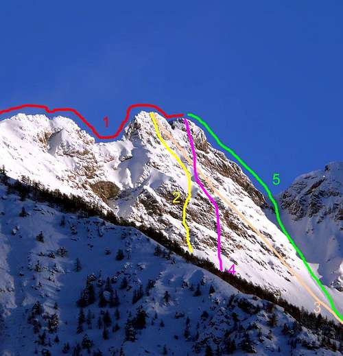
Western Summit of Tsaat a l'Etsena(2.971m); gives as for the most elevated it is inferior instead of some meter to the East Point, as from comparison on the spot and from various photos that here we introduce. Climbed by the Abbé Henry, only, Jul 13 th, 1923, that reached it from the Comba of Verdzignola in Valpelline presumably earning the crest watershed near the Collar 2.930/35 meters, turning the Edge in West and finishing for the brief Wall Southwest, where it also passed in crossing the rope Quendoz-Jorrioz in 1972; the West Edge was integrally climbed instead in the 1992 crossing. Climbed besides in winter on Dec 22th, 1985 from the rope Cardellina-Ferronato-Lamazzi that used for the slope the East Edge, of rocks very steep and enough difficult, passing to the right or North of the itinerary effected in descent from Quendoz-Jorrioz and gathering itself to this only in the last 5/6 meters, cause the verglass. The descent happened for the Slope South-southeast. Another route was opened by Osvaldo Cardellina, only, which in the same day directly climbed for the South Wall, gone down along the identical slope of which above and it also went up again the South Wall of the East Point, in date Sep 26 th, 1999. Pass of Tsaat a l'Etsena(2.910/15 meters around); sets among the two Summits it was so baptized by the Abbé Henry (sundry bibliographical signs and RM C.A.I. 1913, pages 98/100 with relationship and photo). Oriental Top(2.967 meters about or better 2.974/5 meters about); in more elevated reality of a pair of meters the preceding one, as from analysis on the spot and from comparison photographic enclosure; climbed by the Abbé, only, Sep 02th, 1912, after an attempt of the same that refolded on the neighbors Beaks of Fana Aug 12 th, 1912 for the great South Crest. An attempt of first winter for this street he was also tried by the rope Garzotto-Cardellina Jan 06th, 1969 departing from Trois Villes Village, but it stranded too anymore not in there of the Croix de Fana, cause the tall snow too much. The first winter was realized instead, always with equal point of departure, from the rope Cardellina-Cossard-Lamazzi-Ferronato Jan 26th, 1974; in the occasion the great South couloir of the Hill of Fana was used, for then to continue cutting to the right the East Slope and to finish in the final line of the Crest North-northeast, route already used by the Abbé for the first slope with departure from the Hill of Saint Barthélemy, but passing below the Point 2.918 meters, that he then will subsequently be devoted him. Three days after the first three also effected the first winter ascension to the Becchi of Fana, with the same itinerary up to the Pass of Fana and then diverting on the Northern Slope of the same. The complete crest up to the Hill of Saint Barthélemy was crossed in climbed by the rope Cardellina-Lamazzi Aug 20th, 1978, that continued then up to the Beaks of Fana, crossing them all and descending in Comba Dèche through the Fana Collar2.940 meters around; this "via" is pointed out as normal route from Gino Buscaini in "Alpe Pennine Vol. II°", pages 572/3 with squirt n°79, rather holding the slope of the Hill of dangerous Fana. The hypothesis doesn't find a lot us of accord, since we hold correct exactly the contrary one, considering in every case dangerous the slope on both the fronts in presence of abundant snow. Hill of Fana(2.880 meters about); among the East Point of the Tsaat a l'Etsena and the Antesummit West2.945 meters around of the Becchi of Fana, with all the preceding considerations. The first slope is unknown, while the first winter happened in the occasion of the winter one to the East Point, follows Dec 29th, 1974 from that to the homonym Beaks. From the Point of Tsaat a l'East Etsena an important buttress unties at first him in direction Northeast forming before a secondary carving that goes down in way West horrifying to which they follow two small squared towers and you cut; subsequently, after an i carve very clean that goes down Northwestern, very steep and boxed, toward the Comba of Verdzignola(z) in Valpelline and with smaller exposure toward Southeast on the Comba Dèche (he could nicely be calls Carving of the Abbot2.895/2.900 meters around) preceding the Point Joseph Maria Henry(2.918m). The crest watershed continues in direction Northeast and successively, after a small and meaningless carving, it reaches a more marked depression (he could be suitable as Conge Pass; 2.871m) with the same consideration of the precedent to the respect of its crossing reaching finally the Becca Conge(2.954m), the most elevated of this second line of crest watershed, that divides the Valpelline from the Valley of Saint Barthélemy up to the homonym very important Pass(2.645/6m), what it reaches unfolding, after the acute carving of the Antesummit North(2.927m), a series of quotas and depressions of young person importance (2.918m, 2.781m, 2.828m, 2.765m, 2.703m, 2.714m). Over the crest it raises again him to the imposing Faroma Mountain (3.073m) to continue his run in direction of the fascinating Becca of Luseney(3.504m), to the Northern apex of the Valley of Saint Barthélemy. From this a whole series of tops over the three thousand meters is addressed toward the Petites and the Grandes Murailles, between the Valpelline and the Valtournanche finishing in the extreme knot of the Dent of Hérens(4.172m), where the crest of frontier grafts him that forms the Alps Pennine between Italy and Switzerland. From this point and toward East the Cervino also called Matterhorn and the Rosa Mountain are raised with all of its tops above the 4.000 meters. This great wedge, inserted in the heart of the Valley of Aosta, it finds his Western vertex in the Becca of Roisan, note to the beginning of the "our" small chain, such to form a minuscule subgroup, that ends with the two heads of the Tsaat a l'Etsena. From the Hill of Fana he takes beginning instead another secondary ramification that, after having formed the five Beaks of Fana (2.951m; four anymore an Antesummit Western 2.945 meters around), it goes down toward South-southeast in direction of the Central Valley of the it Dora up to the three Villages of Trois Villes (1.391m) above the Communes of Quart and Nus. This long buttress but of modest appearances it forms, road doing, the Tall Pass(2.540 meters around), the Northern Point of the Cornet also Quota2.484 meters around, the homonym Pass(2.272m), the Southern Point or Quota2.306 meters, the Collar2.226 meters to finish with the Croix de Fana(2.222m), splendid belvedere (= viewpoint) set to form of advanced balcony on the development of big part of the Central Valley of the Dora Baltea.
CONTRAFFORTE BECCA di VIOU- MONT MARY-TETE d’ARPISSON-PUNTA di SENEVE'-TSAAT a l'ETSENA-BECCHI di FANA. REMARQUES di TOPOGRAFIA, di TOPONOMASTICA e STORICHE Importante Remarque:questa monografia è da intendersi quale completamento e complementarità, grazie alle numerose personali "scorribande" soprattutto giovanili, dei ed ai lavori dell'Abbé Henry "Guida della Valpelline", 1925 e di Gino Buscaini "Alpi Pennine Vol. II°", C.A.I./T.C.I. 1971, tali da rimanere sempre come opere fondamentali e basilari, nonché sicuramente utili a risvegliare la voglia di ricerca e di scoperta da parte dei giovani in un settore di montagne sconosciuto per non dire negletto ai più.
***
Questa bella e doppia piramide s'innalza sulla catena montuosa, atta a separare la Valpelline, a Settentrione, dalla Valle Centrale del Fiume Dora Baltea a Mezzogiorno, sommità la più alta su questo tratto di cresta, che forma fino ai Becchi di Fana, con relativa Cresta Sud-sudest declinante sino alla Croce di Fana, un grande fauteil (= poltrona) sovra i Comuni di Roisan, Aosta, Saint Christophe e Quart nella parte mediana della Valle Centrale del Fiume Dora Baltea. La stessa costiera, pressoché esclusivamente rocciosa, inizia con la minuscola Becca di Roisan(2.546 m), detta anche Becca di Pechenville (in SP, sopra i Comuni di Valpelline (960 m) a Nordovest e di Roisan ad Occidente (866 m). Dopo una larga Sella 2.482 m (potrebbe essere chiamato Colle di Roisan permettendo il transito per mezzo di un ripido canalino roccioso in diagonale da Est ad Ovest sulla pietraia soprastante i ruderi dell'antica Alpe Baraques (2.383 m) in Valpelline; percorso sicuramente già in vecchi tempi utilizzato da cacciatori o da alpigiani in transito tra la Comba di Valfreyde in Valpelline e le Alpi di Viou, nonché il Villaggio di Blavy) raggiunge una quota secondaria o Becca di Blavy(2.508 m), altrimenti individuabile nella ex Quota 2.494 in I.G.M. La stessa si rialza alla più imponente Becca di Viou(2.856 m; vetta sicuramente più conosciuta e frequentata dell'intero piccolo sottogruppo, anche perché dominante la Città di Aosta. In questo tratto, ed alla base alla minuscola quota 2.561 m della Cresta Ovest-nordovest della Viou, esiste un'altra, ma ben più piccola e duplice sella tra una piccola protuberanza rocciosa, tale che potrebbe essere indicata come Colle di Blavy (2.495/2.500 metri circa la Depressione Occidentale e 2.520/5 metri circa la piccola Sella Inclinata Orientale), facilmente raggiungibili da Sud; mentre dal lato opposto a Settentrione presenta una paretina abbastanza impegnativa di una trentina di metri. Può essere utilizzato, più che per la traversata, per dar inizio alla salita della suddetta cresta, che però dal lato Valpelline viene solitamente raggiunta in un punto maggiormente elevato, ovvero intorno ai 2.730/50 metri circa. Dalla Becca discesa all'omonimo ed importante Colle(2.696/8 m), vicino al quale da poco tempo è stato posizionato il Bivacco Penne Nere (2.730 m; l'unico in tutta la piccola Catena Montuosa), presso un'appendice rocciosa e frastagliata poi precipitante a Settentrione sopra il Lago di Arpisson(2.482 m) l'unico dell'intero piccolo Sottogruppo, conosciuta come Mont Trembloz(2.735 metri circa), la cresta spartiacque si rialza nel corpulento Mont Mary(2.815 m); oppur detto in loco Mont Saint Joseph,
che domina i Comuni di Saint Christophe e di Quart, e prosegue verso Nordest formando tutta una serie di puntine e torrette inframezzate da vari colletti, per la verità scarsamente utili al transito ed in pratica poco o del tutto non frequentati, come d'altronde le punte medesime formate da rocce ostiche alla vista dal basso, con roccia non buona e friabile e frammista a tratti erbosi piuttosto pericolosi. Per tutto questo tratto di cresta, che a partire dalla Becca di Roisan raggiunge il Mont Mary, scavalcando la Becca di Viou e transitando attraverso l'omonimo Colle, rinviamo alla già preesistente e dettagliata analisi effettuata nelle pagine relative, di già postate in SP. Sicuramente c'é da osservare come questo tratto di cresta spartiacque, almeno per quanto concerne la liaison Becca di Viou-Mont Mary, risulta esser il più frequentato dell'intera catena sia per la facilità di salita di queste due cime, sia perché l'intermedio Colle di Viou é meta di passaggio facile, sicura nonché molto frequentata tra la Comba di Blavy e la Valpelline, tanto ne é che dal Comune di Roisan risale un sentiero Inter Vallivo siglato con il n° 102, discendente verso il Vallone di Arpisson. Per quanto concerne il Mont Mary, da sottolineare come possa costituire una bella gita di sci-alpinismo partendo dal Villaggetto di Chamerod e, attraverso la Comba di Senevé, risalita del suo Versante Sudest; anche la gita con racchette da neve insino all'Alpe di Senevé é alquanto piacevole e remunerativa con splendide viste sull'antistante Gruppo del Monte Emilius. Questa parte di cresta é misconosciuta da parte degli alpinisti e degli escursionisti, mentre la cresta spartiacque procedente verso Oriente, e della quale parleremo subito appresso, risulta scarsamente frequentata tanto che le ascensioni posson contarsi sulla punta delle dita delle mani; essa é rivolta a spiriti avventurosi, che amano uscire dai percorsi solitamente frequentati e dai nomi altisonanti; essa regala però emozioni e solitudini sempre più irreperibili in montagna. E tutto questo a due passi dalla città!
Quindi, a partire del Mont Mary, con direzione da Sudovest prima verso Est eppoi Nordest in direzione del Colle di Saint Barthélemy ed infine dai Becchi di Fana a Sud-sudest insino alla Croix de Fana, l'ordine progressivo dei quali è il seguente: Col Chaudière Sudovest (2.735 metri circa) oppure volendo, e forse meglio, Colle del Mont Mary, essendone più appropinquato; piccola sella detritica tra la Cresta Nordest del Mont Mary e la Punta di Chamerod; di accesso elementare sul Versante Sud per roccette e fine detrito, scende più dirupata verso Settentrione sopra il Lago di Arpisson (2.482 m) e non è di utilità per l'attraversamento tra la Conca di Senevé ed il Vallone di Arpisson, essendo da preferire il Colle Nordest, veramente anche lui poco frequentato, se non da isolati e sporadici cacciatori. Punta di Chamerod(2.750/2 metri circa); prende il nome dalla sottostante località formato da alcune costruzioni ristrutturate, fino agli inizi degli anni Settanta costituiti da vecchi rascard (= costruzione in legno sospesa tramite alcuni piccoli pilastri su di un basamento in pietra; vedi foto) tra i quali uno molto bello e significativo. Informazione avuta in loco da pastore della zona nel 1971; non quotata ne denominata su di alcuna carta, manuale o libri. Costituisce il naturale prolungamento della Cresta Nordest del Mont Mary, esattamente nel punto in cui questa piega maggiormente ad Est; sul Versante Nordovest precipita con una breve, giallognola e quasi verticale parete sul Vallone dell'Arpisson in Valpelline. Salita (per la prima volta?) da Osvaldo Cardellina e Marco Périer il 30 Marzo 1969 in traversata dalla Becca di Viou e ritorno alla medesima; visitata anche d'inverno il 23 Febbraio 1975 da parte di Osvaldo Cardellina, Marco Cossard e Giuseppe Lamazzi in un'ascensione senza sci e neppure racchette da neve, con partenza dal Villaggio di Blavy (1.475 m) e traversamento in cresta al Mont Mary ed alla Punta di Chamerod, ritorno identico e prolungamento fino alla Becca di Viou. Intaglio di Chamerod(2.740/2 metri circa); prende il nome dalla omonima punta risultando una piccola breccia tra la stessa e la Punta Occidentale de Les Prèles. Di facile accesso da Mezzogiorno, presenta un versante ostico a Settenterione, per la quale cosa il transito é sconsigliabile e sicuramente non facile, poiché sviluppantesi in una paretina di 150 metri circa incuneata tra le due costoline rocciose provenienti dall'omonima punta e da quella delle Prèles; é formata da rocce rotte ed abbastanza ripide ed esposte alla caduta di sassi. Punta delle Prèles oppure Preyes od anche Preilles (2.747/8 metri circa la piccola e bifida sommità Occidentale e 2.750/1 metri quella più frastagliata Orientale); subito ad Oriente del colle e della punta precedenti, è formata da una serie di piccole sommità poco evidenti con rocce lisce, ma fratturate e di facile salita sulo Versante Meridionale. Identiche le considerazioni come per la Punta di Chamerod. Salita (per la prima volta?) da Osvaldo Cardellina e Saverio Cusumano il 3 Settembre 1971, in traversata dal Mont Mary e ritorno al medesimo, nonché susseguente attraversata alla Becca di Viou. Intaglio de Les Prèles(2.738/40 metri circa); prende nome dalle due punte omonime il minuscolo intaglio posto ad esser tra le medesime; identiche osservazioni che per la precedente breccia, ma le difficoltà del percorso sono ancora più impegnative e pericolose con rocce ripide sovrastanti alcune lingue di neve residua.
Col Chaudière Nordest (2.746 m nella "Carta l'Escursionista Conca di Aosta Pila - Monte Emilius n°4"; 2.680 metri circa in "Alpi Pennine Vol. II°", pag. 578, di Gino Buscaini; 1970); intaglio più marcato sulla cresta spartiacque consente il passaggio tra la Valle Centrale della Dora Baltea e la Valpelline. E' sicuramente il passaggio più semplice e meno pericoloso, dopo il ben più noto e frequentato Colle di Viou, lungo l'intera catena tra le due località, formato da entrambi i lati da detriti con terriccio e pietraie e "clapeys" con tratti erbosi nei tratti mediani e basali. Situato alla base della cresta Sudovest della Tête d'Arpisson ed utlizzato per la prima salita invernale di quest'ultima nel 1975, valgono le considerazioni fatte per l'omologo Colle Sudovest o del Mont Mary. Tête d'Arpisson conosciuto in loco anche come Pelon de Quart(2.856/7 m); è costituito da una piccola piramide con tre creste: due lungo l’asse Sudovest/Nordest sulla cresta spartiacque, mentre la terza discende, sempre rocciosa, verso Nord-nordovest sopra il Colle di Fouillou(2.437 m). Salita per la prima volta dall'Abbé Joseph Maria Henry da solo il 19 Agosto 1905; la prima invernale è stata effettuata il 02 Marzo 1975 in traversata dalla Punta di Chamerod-Punta de Les Prèles- Col Chaudière Nordest e finale per la Cresta Sudovest, da parte di Osvaldo Cardellina, Marco Cossard e Giuseppe Lamazzi con partenza dall'Alpe di Chamerod (1.614/5 m), con in discesa lo stesso percorso in senso opposto. Già trattato in SP in data 03 Gennaio 2008. Sella d'Arpisson(2.865 m circa); larga e lunga Sella tra la Tête d'Arpisson e la Quota 2.888 metri circa, la depressione massima della quale é più viciniore a questa ultima; di accesso infido per la molta erba esistente sulle rocce del Versante Sud, anche da Nord presenta un versante di rocce rotte e detriti. Sconsigliabile su di entrambi i lati e di praticità praticamente nulla, risulta più un passaggio per cacciatori esperti ed avventurosi che non un valico. Quota2.888 m formata da una serie di torrioni varii; situata all'estremità Orientale della Cresta Nordest della Tête d'Arpisson che, dopo un tratto pseudo rettilineo, forma quattro protuberanze caratteristicamente ricurve ben più in evidenza e, dopo un minuscolo intaglio, si rialza ad una piccola antecima ed al punto maggiormente elevato, anch'essi penzolanti. Colletto2.850 metri circa; è costituito da un doppio intaglio alla base della Cresta Est-nordest della Quota 2.888 metri, a cavallo del quale si innalza una piccola ed elegante piramide. Si propone di chiamarli Colletti Occidentale ed Orientale di Senevé. Il suo Versante Settentrionale scende verso la piccola Comba di Fouillou, secondaria ed ad Est del Vallone d'Arpisson nella Valpelline Meridionale, ed è formato da ripide costole di rocce rotte, mentre a Sud lascia cadere con direzione Sud-sudest verso la Comba di Senevé un evidente ed abbastanza ripido, ma facile, canalone detritico; lo stesso è stato utilizzato dalla cordata Quendoz-Jorrioz nell'Estate del 1972 (se la memoria non mi inganna) per iniziare la traversata in cresta insino al Colle di Fana. Campanilino o Guglia di Senevé(2.875/7 metri circa); slanciata e minuscola piramide, possiede le linee di un Cervino in miniatura e si propone di battezzarlo come Campanile di Senevé, dalla località subito sottostante. Risulta salito per la prima volta da Osvaldo Cardellina l'11 di Ottobre 1992, nella lunga ed estenuante traversata in cresta dalla Becca di Roisan alla Croix de Fana; la cordata Quendoz-Jorrioz del 1972 lo scartò a destra attaccando sulla forcella immediatamente ad Est. Punta di Senevé(2.928 m); dal Colletto Orientale di Senevé sale una Cresta Sudovest breve ma ripida ed accidentata, tanto che l'Abbé Henry la riteneva impraticabile. E' stata salita per la prima volta dalla cordata 1972, parzialmente percorsa in discesa e risalita dalla Punta di Senevè ancora nello stesso anno e ripercorsa nella traversata di giusto venti anni dopo; meno difficile del previsto, richiede prudenza per la qualità della roccia, alquanto sgretolata con materiale sospeso. La montagna, il vertice della quale si trova proiettato e quasi "disteso" ad Occidente, presenta due versanti; uno a Sud di rocce rotte cosparse da tratti erbosi che, con uno sperone appena delineato e terminante sulla Cresta Est a poca distanza dalla Vetta presso un'Antecima Nord2.926 metri circa, può costituire la Via Normale. Fu salito l'8 di Ottobre 1972 da Osvaldo Cardellina e Camillo Roberto Ferronato in salita e discesa con partenza da Chamerod, in quella che costituisce la seconda o la prima ascensione della montagna (nella salita del 1972 manca la data precisa). Nell'occasione venne percorsa parzialmente in discesa e poi salita la Cresta Sudovest. Sempre con questo itinerario avvenne la prima ascensione invernale da parte di Osvaldo Cardellina, solo, il 30 Dicembre 2007. L'altro versante, rivolto verso Settentrione, è costituito da costole rocciose non molto ripide e con tratti frantumati fino alla torretta terminale formata da rocce più ripide; può essere, a nostro avviso, adatto allo sci-alpinismo nella giusta stagione.
Colle di Senevé (2.910/15 metri circa; larga sella posta tra l'omonima punta e la frastagliata Quota 2.945/50 metri circa. Passaggio di non grande utilità e probabilmente mai frequentato. Da Sud risalire con lo Sperone Sud-sudovest della Punta di Senevé, per poi attraversare a destra (Est) nella parte finale; oppure attaccare alla base della Quota 2.945/50 metri circa, iniziando la salita in una strettoia formata da piccole costole rocciose introducenti al superiore e più lineare pendio, e con un lungo diagonale verso sinistra, su rocce rotte ricoperte da molta erba, raggiungerlo. Sul lato Nord risalire tramite rocce frantumate miste a detrito. Anche questo sconsigliabile, soprattutto in presenza di neve abbondante. Salita per cacciatori esperti. Quota2.945/50 metri circa; dalla Punta di Senevé la cresta continua quasi rettilinea raggiungendo facilmente una quota arrotondata. Colletto2.930/35 metri circa; alla base dello Spigolo Occidentale della Punta Ovest della Tsaat a l'Etsena; come per la precedente quota, raggiunto in traversata Ovest/Est. I suoi versanti sono sconsigliabili per la pessima qualità della roccia, ricoperta da erba sul versante Meridionale e da rocce rotte, detrito o resti di nevati su quello esposto a Settentrione con percorsi similari se non identici per entrambi e con le medesime considerazioni di cui sopra. Punta Occidentale di Tsaat a l'Etsena(2.971 m); data come per la più elevata è invece inferiore di qualche metro alla Punta Est, come da riscontro in loco e da varie fotografie, che qui presentiamo. Salita dall'Abbé Henry, solo, il 13 Luglio 1923, che la raggiunse dalla Comba di Verdzignola in Valpelline guadagnandone la cresta spartiacque presumibilmente presso il Colletto 2.930/35, aggirando lo Spigolo Ovest e terminando per la breve Parete Sudovest, dove passò in traversata anche la cordata Quendoz-Jorrioz nel 1972; lo Spigolo Ovest venne invece salito integralmente nella traversata del 1992. Salita inoltre in inverno il 22 Dicembre dalla cordata Cardellina-Ferronato-Lamazzi, che ne utilizzò per la salita lo Spigolo Est, di rocce molto ripide ed abbastanza difficili, passando più a destra o Nord dell'itinerario effettuato in discesa da parte di Quendoz-Jorrioz e riunendosi a questo solamente negli ultimi 5/6 metri, causa il verglass. La discesa avvenne per il Versante Sud-sudest. Un'altra via venne aperta da Osvaldo Cardellina, solo, il 26 Settembre 1999, che nello stesso giorno salì direttamente per la Parete Sud, scese lungo l'identico versante di cui sopra per poi risalire anche la Parete Sud della Punta Est. Colle di Tsaat a l'Etsena(2.910/15 metri circa); posto tra le due Sommità fu così battezzato dall'Abbé Henry (varii cenni bibliografici e RM C.A.I. 1913, pagine 98/100 con relazione e foto). Punta Orientale(2.967 m o meglio 2.974/5 m circa), in realtà più elevata di un paio di metri della precedente, come da analisi in loco e da riscontro fotografico allegato; salita dall'Abbé, solo, il 2 Settembre 1912, dopo un tentativo dello stesso ripiegante sui vicini Becchi di Fana il 12 Agosto 1912 per il Crestone Sud. Un tentativo di prima invernale per questa via fu tentato anche dalla cordata Garzotto-Cardellina il 6 Gennaio 1969 partendo da Trois Villes, ma si arenò non troppo più in là della Croix de Fana, causa la neve troppo alta. La prima invernale venne realizzata invece, sempre con ugual punto di partenza, dalla cordata Cardellina-Cossard-Lamazzi-Ferronato il 26 Gennaio 1974; nell'occasione venne utilizzato il grande canale a Sud del Colle di Fana, per poi proseguire tagliando a destra il Versante Est e terminare nel tratto finale della Cresta Nord-nordest, via già utilizzata dall'Abbé per la prima salita con partenza dal Colle di Saint Barthélemy, ma passando al di sotto della Punta 2.918 metri, successivamente dedicatagli. Tre giorni dopo i primi tre effettuarono anche la prima ascensione invernale ai Becchi di Fana, con lo stesso itinerario fino al Colle di Fana per poi deviare sul Versante Settentrionale degli stessi. La cresta completa fino al Colle di Saint Barthélemy venne percorsa in salita dalla cordata Cardellina-Lamazzi il 20 Agosto 1978, che poi proseguì fino ai Becchi di Fana, attraversandoli tutti e cinque per successivamente discendere in Comba Dèche tramite il Colletto 2.940 metri circa; questa via viene indicata come via normale da parte di Gino Buscaini in "Alpi Pennine Vol. II°", pagine 572/3 con schizzo n°79, ritenendo la salita del Colle di Fana alquanto pericolosa. L'ipotesi non ci trova molto d'accordo, dacché riteniamo giusto esattamente il contrario, considerando in ogni caso pericolosa la salita su entrambi i fronti in presenza di abbondante neve. Colle di Fana(2.880 metri circa); tra la Punta Est della Tsaat a l'Etsena e l'Antecima Ovest2.945 metri circa dei Becchi di Fana, con tutte le considerazioni precedentemente eposte. La prima salita è ignota, mentre la prima invernale avvenne nell'occasione dell'invernale alla Punta Est, seguita il 29 Dicembre dello stesso anno da quella agli omonimi Becchi. Dalla Punta di Tsaat a l'Etsena Est un contrafforte importante si snoda dapprima in direzione Nordest formando prima un intaglietto secondario che scende in modo abrupto ad Ovest al quale seguono due torrette squadrate e mozze; in seguito un'intaglio molto netto che scende a Nordovest, molto ripido ed incassato, verso la Comba di Verdzignola(z) in Valpelline e con minore esposizione verso Sudest sulla Comba Dèche (potrebbe simpaticamente essere chiamato Intaglio dell'Abbé; 2.895/2.900 m circa) precedente la Punta Joseph Maria Henry(2.918 m). La cresta spartiacque continua in direzione Nordest e, dopo un insignificante intaglietto, raggiunge una depressione più marcata (potrebbe essere indicato come Col Conge; 2.871 m) con le medesime considerazione del precedente al riguardo del suo scavalcamento raggiungendo infine la Becca Conge(2.954/7 m), la più elevata di questo secondo tratto di cresta spartiacque, divisoria la Valpelline dalla Valle di Saint Barthélemy fino all'omonimo molto importante Colle(2.645/6 m), che raggiunge dispiegando, dopo l'acuto intaglio dell'Antecima Nord(2.927 m) tutta una serie di quote e depressioni di minor importanza (2.918 m, 2.781 m, 2.828 m, 2.765 m, 2.703 m, 2.714 m). Oltre la cresta si rialza all'imponente Monte Faroma(3073 m) per continuare la sua corsa in direzione dell'affascinante Becca di Luseney(3.504 m), all'apice Settentrionale della Valle di Saint Barthélemy. Da questa tutta una serie di cime oltre i tremila metri si indirizza verso le Petites e le Grandes Murailles tra la Valpelline e la Valtournanche terminando nel nodo estremo della Dent d'Hérens(4.172 m), ove innestasi la cresta di frontiera che forma le Alpi Pennine tra l'Italia e la Svizzera. Da questo punto e verso Est si elevano il Monte Cervino ed il Monte Rosa con tutte le sue cime al di sopra dei quattromila metri. Questo grande cuneo, inserito nel cuore della Valle d'Aosta, trova il suo vertice Occidentale nella Becca di Roisan, appunto all'inizio della "nostra" piccola catena, tale da formare un minuscolo sottogruppo, che finisce con le due teste della Tsaat a l'Etsena. Dal colle di Fana invece prende inizio un'altra ramificazione secondaria che, dopo aver formato i cinque Becchi di Fana (2.951 m; quattro più un'Antecima Ovest 2.945 metri circa), scende verso Sud-sudest in direzione della Valle Centrale della Dora fino ai tre Villaggi di Trois Villes (1.391 m) sopra i Comuni di Quart e di Nus. Questo contrafforte lungo ma di modeste apparenze forma, strada facendo, il Passo Alto(2.540 metri circa), la Punta Settentrionale del Cornet nella Quota2484 metri circa, l'omonimo Colle(2.272 m), la Punta Sud oppure Quota2.306 m, il Colletto2.226 m per terminare con la Croix de Fana(2.222 m), splendido belvedere posto a forma di balcone avanzato sullo sviluppo di gran parte della Valle Centrale della Dora Baltea.
Topographical notes and orographical and development of the succession of the quotas of altitude
Topographical notes and orographical and development of the succession of the quotas of altitude. We trace in synthetic way and recapitulation of the sequence of the various quotas with West direction to East, as well as relative, beginning from the Oriental Point of the Tsaat a l'Etsena, to the splitting in Northeast i pour the Hill of Saint Barthélemy and to East and then South-southeast toward the Croix de Fana; besides we will put in evidence the essential topographical knots, signalling the same with an asterisk.
A) - Section Becca of Roisan/Tsaat a l'Etsena to East: Pecks of Roisan 2.546m-Hill of Roisan 2.482m-Pecks of Blavy 2.508m-Necks of Blavy Western 2.495/2.500 meters around and Eastern 2.520/5m-Pecks of Viou 2.856m (* it sends a small ramification toward North-northwest, that concludes him with the Tête de Valfreyde 2.638m)-Hill of Viou 2.696m (* it sends a small ramification toward North-northeast, that finishes with the Mont Tre(a)mbloz 2.716m)-Mount Mary 2.814/5m (* it sends three ramifications toward South: the first Southwest in direction of the Tsa de Viou 2.202m with a steep rib at first rocky (he has not at all been climbed already with snowshoes in an easy excursion) that it contains the small underlying superior basin the homonym hill for then to sink dizzy toward the gorge of the little Village of Parléaz; the same one divides around him in other two ramifications to quota 2.300/50 meters about above a band of steep dark rocks. The more branch to West, formed a rocky pulpit, goes down in direction of the Fraction of Porossan, above Aosta and of the Quota BP (Baden Powell) with its protected area. The second branch, orographically to the right, that it finishes to quota 1.996m above the small Village of Valtolana(z) 1.492m. The second that is undoubled around to quota 2.250m to South-southeast, cut by an ancient slender path that gathers the two Alps of Viou with that of Senevé also Cenevé (2.199m), going down in direction of the Villages of Cerisolaz 1.159m, Cretallaz 1.087m and Jeanceyaz 1.095m and the third and last descends to Southeast above the Alps of Rachaou 1.612m, Ayette 1.467m and Chamerod 1.614m)-Mary Hill 2.735m around-Point of Chamerod 2.750/2m around-Chamerod Carving 2.740/2 meters around-Summit West of the Prèles 2.747/8 meters around-Carving of Les Prèles 2.738/40 meters around-Top East 2.750/1 meters around-Col Chaudière NE 2.746m-Tête of Arpisson 2.857/8m (* it sends a small ramification toward North-northwest toward the Fouillou Pasture 2.092m)-Saddle of Arpisson 2.865m around-quota West 2.888m-Collar of Senevé 2.850 meters around-Little Bell Tower of Senevé 2.875/7 meters around-Collar East 2.850 meters around-Point of Senevé 2.928m (* it sends a triplex ramification toward North, North-northwest and Northwest, this it completes the most important in direction of the Hill of Fouillou 2.437m that it finishes with the Becca Noail or Novailloz 2.587m, above the homonym Bois in Valpelline)-Hill of Senevé 2.910/15 meters around-Quota 2.945/50 meters around-Collar 2.925/30 meters around-Western Top of Tsaat a l'Etsena 2.971m-Pass of Tsaat al'Etsena 2.910/15 meters around-Oriental Top 2.967m around, but in reality 2.974/5 meters around (* it sends two ramifications: a very important toward Northeast up to the Hill of Saint Barthélemy and a second to the Hill and the Beaks of Fana).
B) - Section Tsaat to the Etsena Est/Saint Barthélemy Pass: Tssat a l'Etsena Eastern Top 2.974/5 meters around-Carving of the Abbot 2.895/2.900ms it around-Point Joseph Maria Henry 2.918m-Hill Conge 2.871m-Becca Conge 2.954/7m (* it sends a brief ramification toward North-northeast above the Alp de the Arpeyssaou 2.160m; among quota 2.916m or Antetop Northern and quota 2.781m send a great North-northwest ramification above the Pass de la Lliée or Lière 2.556m, that then, after the homonym Point 2.525m, reach the Arpeyssaou Pass 2.492m near the Bivouac of the Lière 2.423m for finally to get up forming Morion Pecks 2.713/9 meters according to the maps, above the Comba of Verdona in the Commune of Oyace in Valpelline)-Hill of Saint Barthélemy 2.645/6m.
C) - Section Tsaat al'Etsena Oriental Point/Becchi of Fana/Croix de Fana: Hill of Fana 2.880 meters around-Antesummit West of the Beaks 2.945 meters around (* secondary ramification that, after having formed the four Beaks of Fana 2.951m the tallest, it goes down toward South-southeast in direction of the Central Valley of the Dora up to the three Villages of Trois Villes 1.391m forming the Tall Hill 2.540 meters around-Point North of the Cornet 2.484 meters around-Cornet Pass 2.272m - Point South of the Cornet 2.306m-Collar 2.226m- Croix of Fana 2.222m.
Note topografiche ed orografiche e sviluppo della successione delle quote di altitudine. Tracciamo in modo sintetico e riepilogativo il succedersi delle varie quote con direzione da Ovest in Est, nonché relativo, a partire dalla Punta Orientale della Tsaat a l'Etsena, allo sdoppiamento in Nordest verso il Colle di Saint Barthélemy ed ad Est ed infine Sud-sudest verso la Croix de Fana; inoltre metteremo in evidenza i nodi topografici essenziali, segnalando gli stessi con un asterisco.
A)- Sezione Becca di Roisan/Tsaat a l'Etsena Punta Est: Becca di Roisan 2.546 m-Colle di Roisan 2.482 m-Becca di Blavy 2.508 m-Colli di Blavy Ovest 2.495/2.500 metri circa ed Est 2.520/5 m-Becca di Viou 2.856 m (* invia una piccola ramificazione verso Nord-nordovest, concludentesi con la Tête de Valfreyde 2.638 m)-Colle di Viou 2.696 m (* manda una piccola ramificazione verso Nord-nordest, che termina con il Mont Tre(a)mbloz 2.716m)-Mont Mary 2.814/5 m (* scende con tre ramificazioni verso Sud: la prima a Sudovest in direzione della Tsa de Viou 2.202 m con un ripido costolone dapprima roccioso (é già stato salito con racchette da neve in un'escursione per nulla facile), racchiudente il piccolo bacino superiore sottostante l'omonimo colle per poi sprofondare vertiginosamente verso la forra del piccolo Villaggio di Parléaz; la stessa si divide in altre due ramificazioni a quota 2.300/50 metri circa sopra una fascia di ripide rocce scure. Il ramo più ad Ovest, formato un pulpito roccioso, scende in direzione della frazione di Porossan, sopra Aosta e della Quota BP (Baden Powell) con la sua area protetta. Il secondo, più a destra orograficamente, si smussa a quota 1.996 m sopra il Villaggetto di Valtolana(z) 1.492 m. La seconda branca, sdoppiantesi a quota 2.250 metri circa a Sud-sudest, tagliata da un antico sentierucolo che riunisce le due Alpi di Viou con quella di Senevé o Cénevé (2.199 m), cala in direzione dei Villaggi di Cerisolaz 1.159 m, Cretallaz 1.087 m e Jeanceyaz 1.095 m. La terza si indirizza a Sudest sopra le Alpi di Rachaou 1.612 m, Ayette 1.467 m e Chamerod 1.614 m)-Col Mary 2.735 m circa-Punta di Chamerod 2.750/2 metri circa-Intaglio di Chamerod 2.740/2 metri circa-Punta Ovest de Les Prèles 2.747/8 metri circa-Intaglio de Les Prèles 2.738/40 metri circa-Punta Est 2.750/1 metri circa-Col Chaudière NE 2.746 m-Tête d'Arpisson 2.857/8 m (* spinge una piccola ramificazione verso Nord-nordovest verso l'Alpe Fouillou 2.092 m)-Sella d'Arpisson 2.865 metri circa-Quota 2.888 m-Colletto Ovest di Senevé 2.850 metri circa-Campanilino di Senevé 2.875/7 metri circa-Colletto Est 2.850 metri circa-Punta di Senevé 2.928 m (* invia una triplice ramificazione verso Nord, Nord-nordovest e Nordovest, quest'ultima la più importante in direzione del Colle di Fouillou 2.437 m terminante con la Becca Noail, oppure Novailloz, 2.587 m sopra l'omonimo Bois in Valpelline)-Colle di Senevé 2.910/15 metri circa-Quota 2.945/50 metri circa-Colletto 2.925/30 metri circa-Punta Occidentale di Tsaat a l'Etsena 2.971 m-Colle di Tsaat a l'Etsena 2.910/15 metri circa-Punta Orientale 2.967m circa, ma in realtà 2.974/5 metri circa (* inoltra due ramificazioni: una molto importante verso Nordest fino al Colle di Saint Barthélemy ed una seconda verso il Colle ed i Becchi di Fana).
B)- Sezione Tsaat a l'Etsena Est/Colle di Saint Barthélemy: Tsaat a l'Etsena Punta Est 2.974/5 metri circa-Intaglio dell'Abbé 2.895/2.900 metri circa-Punta Joseph Maria Henry 2.918 m-Col Conge 2.871 m-Becca Conge 2.954/7 m (* invia una breve ramificazione verso Nord-nordest sopra l'Alpe de l'Arpeyssaou 2.160 m; tra quota 2.916 m o Antecima Nord e quota 2.781 m discende con una grande ramificazione a Nord-nordovest sopra il Col de la Lliée oppure Lière 2.556 m, che poi, dopo l'omonima punta 2.525 m, arriva al Col de l'Arpeyssaou 2.492 m presso il Bivacco de la Lière 2.423 m per infine rialzarsi formando la Becca Morion 2.713/9 metri a seconda delle mappe, sopra la Comba di Verdona nel Comune di Oyace in Valpelline)-Colle di Saint Barthélemy 2.645/6 m.
C)- Sezione Tsaat a l'Etsena Punta Orientale/Becchi di Fana/Croix de Fana: Colle di Fana 2.880 metri circa-Antecima Ovest dei Becchi 2.945 metri circa (*ramificazione secondaria che, dopo aver formato i quattro Becchi di Fana 2.951 m il più alto, scende verso Sud-sudest in direzione della Valle Centrale della Dora sino ai tre Villaggi di Trois Villes 1.391 m formando il Passo Alto 2.540 metri circa-Punta Nord del Cornet 2.484 metri circa-Col Cornet 2.272 m- Punta Sud del Cornet 2.306 m-Colletto 2.226 m-Croix de Fana 2.222 m.
CONCLUSIONS and DEDUCTIONS
Conclusions & Deductions
This small analysis makes to understand that the most elevated mountain of this little Subgroup results to be around the Oriental Point of the Tsaat al'Etsena 2.974/5 meters about against the 2.971m of the Western Point, amiss more elevated retention. Then the same is to catalog as GROUP of the Tsaat instead to the Etsena that GROUP of the Becca of Viou (2.856m), surely mostly known and frequented. The Guide C.A.I./T.C.I., 1971, "Alps Pennine Vol. II°", by Gino Buscaini, from the page 557 to the page 582 the entitles instead as " O. - Subgroup FAROMA - VIOU", with homonym small paper 3cm/3Km inserted among the pages 568-9; this is explainable as a descriptive choice of comfort, keeping in mind of the extension of the mountainous chain. In effects almost all the other tops and quotas of the crest watersheds introduce a greater altitude in comparison to the same one; for which thing, and as Edward Whymper reasoning that in the Chain of the Mount Blanc it exclusively individualized three peaks (the same, the Grandes Jorasses and the Aiguille Verte), in the long crest that, gone up again the Mount Faroma, it pushes him up to Becca of Luseney we should recognize only this axle and to hold the whole other manner tops of satellites. For honor of the truth and curiosity, there is besides to notice that from the Becca of Roisan and up to the Hill of Saint Barthélemy, where this small subgroup finishes, the mountain that introduces a greater mass results to be the Mount Mary.
Conclusioni e Deduzioni
Questa piccola analisi fa comprendere come la montagna più elevata di questo piccolo Sottogruppo risulti esser la Punta Orientale della Tsaat a l'Esena 2.974/5 metri circa contro i 2.971m della Punta Occidentale, erroneamente ritenuta più elevata. Quindi lo stesso é da catalogarsi come Gruppo della Tsaat a l'Etsena invece che non come Gruppo della Becca di Viou (2.856 m), sicuramente maggiormente conosciuta e frequentata. La Guida C.A.I./T.C.I., 1971, "Alpi Pennine Vol. II°", di Gino Buscaini, dalla pagina 557 alla pagina 582 lo titola invece come "O. - SOTTOGRUPPO FAROMA - VIOU" con omonima piccola carta 3cm/3Km, inserita tra le pagine 568-9; ciò é spiegabile come una scelta descrittiva di comodo, tenendo conto dell'estensione della catena montuosa. Daltronde quasi tutte le altre cime e quote della cresta spartiacque presentano una maggiore altitudine rispetto alla medesima; per la qual cosa, e ragionando come Edward Whymper che nella Catena del Monte Bianco individuava esclusivamente tre vette (lo stesso, le Grandes Jorasses e l'Aiguille Verte), nella lunga cresta che, risalito il Monte Faroma, si spinge fino alla Becca di Luseney dovremmo riconoscere soltanto quest'asse e ritenere tutte le altre cime a guisa di satelliti. Per onore del vero e di curiosità, c'é inoltre da rilevare che dalla Becca di Roisan e insino al Colle di Saint Barthélemy, dove termina questo piccolo sottogruppo, la montagna che presenta una maggiore massa risulta essere il Mont Mary.
First Ascents
EAST SUMMIT:
First on the Summit: Abbé Joseph Henry, (Sep 02th, 1912).
In winter: Osvaldo Cardellina, Marco Cossard, Camillo Roberto Ferronato and Giuseppe Lamazzi, (Dec 26th, 1974).
E Slope and final part of N-NE Arête (Standard Route to Eastern Summit): Abbé Joseph Henry, (Sep 02th, 1912).
N-NE Arête (from Saint Barthélemy Pass-Quota 2.826m-Quota 2.914m-Becca Conge-First Ascent Absolute of Punta J.M. Henry-Tsaat a l'Etsena Eastern Top and integral traverse to Fana Pass and all five Becchi di Fana and descent to North-northeast through the Collar 2.925m around): Osvaldo Cardellina and Giuseppe Lamazzi, (Aug 20th 1978).
E Little Face (Directly to Summit): Osvaldo Cardellina and Danilo Garzotto; Andrea Broccard Chanoux and A. Prato (Nov 01th, 1986), in ascent.
S-SE Arête: Osvaldo Cardellina and Giuseppe Lamazzi, (Aug 20th 1978), in descent.
E-SE Edge: Osvaldo Cardellina and Danilo Garzotto, (Nov 01th, 1986).
S Face (Direct Line): Osvaldo Cardellina, (Sep 26th,1999).
W Edge (after the crossing from Senevé Collar 2.855m about-Punta di Senevé First Ascent Absolute-Tsaat a l'Etsena Western Summit): Renato Quendoz and Jules Jorrioz, (Summer 1972?), in descent.
Integral crossing from Becca di Roisan-Tsaat a l'Etsena Western and Eastern Summits to Croix de Fana (Becca di Roisan-Quota 2.494m-Becca di Viou-Mont Mary-Quota 2.750/1 about o Punta di Chamerod-Quota 2.748/8m o Punta de Les Prèles-Tete d'Arpisson-Quota 2.888m-Quota 2.865/70m about also Senevé's Little Bell Tower-Punta di Senevé-Quota 2.945/50m about-Tsaat a l'Etsena West and East Tops-Becchi di Fana-Punta del Cornet-Croix de Fana): Osvaldo Cardellina, (Oct 11th, 1992).
WEST SUMMIT:
First on the Summit: Abbé Joseph Henry, (Jul 13th, 1923).
In winter: Osvaldo Cardellina, Camillo Roberto Ferronato and Giuseppe Lamazzi, (Dec 22th, 1985).
Northern Verdzignola Slope of Collar 2.940/45m about and final part of small South-southwest Wall (Normal Route to Western Summit?): Abbé Joseph Henry, (Jul 13th, 1923).
E Edge: Renato Quendoz and Jules Jorrioz, (Summer 1972?), in descent.
E Edge: Osvaldo Cardellina, Camillo Roberto Ferronato and Giuseppe Lamazzi, (Dec 22th, 1985), in ascent.
S-SE Slope: Osvaldo Cardellina, Camillo Roberto Ferronato and Giuseppe Lamazzi, (Dec 22th, 1985), in descent.
S Wall (Direct Line): Osvaldo Cardellina, (Sep 26th,1999).
TECNICAL OBSERVATIONS for the ASCENTS
Tecnical observations for the ascents: The only recommended runs are found in the various crossings on the crest, with the due avoidances long lines more dangerous than of satisfaction in the climb, always for the bad quality of the such rock from not always to offer the due safety. As it regards the Southern slopes they are almost all to discard, apart the Spur South-southeast of the Point of Senevé, that constitutes the Normal Route and the identical slope of the Hill of Tsaat a l'Etsena, that conducts to the Western Summit of the homonym point. As it regards the Northern slopes, to our notice, the only logical and enough safe it results to be what conducts to the Tête of Arpisson, that excessively crosses not a debris slant steep and parallel to a sinuous and rocky band, that is him below almost accompanying it thin to the a narrowing below the Becca Noail (2.582m) and antecedent the Pass of Fouillou. With good and you arrange conditions of snow, he can still constitute a good ski-mountaineering trip in a primitive and wild environment. Sure, and also panoramically pleasant, the slope along the "Crestone" Sud-sudest to the Western Antetop of the Beaks of Fana departing from the Tall Hill or from her well more distant Cross of Fana, on the crest watershed between the Comba of Senevé and the Comba Dèche in Common of Quart. As it regards the slope to the "our2" two principal points as well as mostly in matter, there is to observe as the ascension of the same ones is not difficult, but it never reverts in the banal one, and it is such to be known well the development of the itinerary to follow. For the Oriental Point, to our notice, it is worthwhile the South Slope of the Hill of Fana, where we have never found, despite how much can be thought, during the numerous ascensions effected remarkable falls of stones; the first line of climbed by the same along the Crest East-southeast it is simple, as it is as many easy the crossing of the East and elementary Face the final part on the Crest North-northeast, that originates from the Point J. M. Henry. In case of winter slope or with a lot of snow, it is worthwhile to continue on the Crest East-southeast with greater difficulties instead, but surely surer. Relatively to the Western Point, it is worthwhile to go up again a part of the great underlying channel the Hill of Fana, abandoning it as soon as possible to go himself on the Slope South-souteast and to go up again I pour the Hill of Tsaat a l'Etsena with a diagonal toward Northwest, below the steep rocks of the South Wall of the Oriental Top, paying attention to the falls of stones, in this case possible. Under bad conditions with snow and ice it is worthwhile to watch out a lot of in the crossing of the slant, not being us alternative of slope, while in the final line from the hill to the Peak through the East Edge is had to appraise with attention the choice of the most suitable passages, playing a few with the work, or, if under good conditions, to support on the Slope South-southeast, profit besides to effect the descent toward the channel of Fana. As it regards the walks and the excursions we recommend these departing from West toward East:
1) - Pass of Viou from the Village of Blavy (1.475m), or from that as soon as underlying of Parléaz (small church to be visited and a Napoleonic fireplace on a roof);
2) - Alp of Senevé in the homonym Basin with departures from Trois Villes or from Chamerod Villages;
3) - Tall Pass or Footstep 2.540 meters around with departure from Trois Villes, Alpage Lutta and mini underlying basin the Western Antesummit of the Beaks of Fana;
4) - Croix de Fana (more and more of "fashion" in beginning or end of season) with departure from Trois Villes and reentry along the low part of the Basin of Senevé through the Pass of Cornet.
Osservazioni Tecniche per la salite: Gli unici percorsi consigliati si trovano nelle varie traversate sulla cresta, con i dovuti aggiramenti lungo tratti più pericolosi che di soddisfazione nell'arrampicata, sempre causa la cattiva qualità della roccia tale da non sempre offrire la dovuta sicurezza. Per quanto concerne i versanti Meridionali son quasi tutti da scartare, a parte lo Sperone Sud-sudest della Punta di Senevé, costituentone la Via Normale, e l'identico versante del Colle di Tsaat a l'Etsena, conducente alla Sommità Occidentale dell'omonima punta. Per quanto riguarda i versanti Settentrionali, a nostro avviso, l'unico logico ed abbastanza sicuro risulta esser quello che risale alla Tête di Arpisson, tale da percorrere un pendio detritico non eccessivamente ripido e parallelo ad una fascia sinuosa e rocciosa sottostantegli, accompagnandolo fino quasi ad una "strozzatura" sottostante la Becca Noail (2.582 m) ed antecedente il Colle di Fouillou. Con buone ed assestate condizioni di neve, può risultare una buona gita sci-alpinistica in un ambiente ancora primitivo e selvaggio. Sicura, ed anche panoramicamente piacevole, la salita lungo il Crestone Sud-sudest all'Antecima Ovest dei Becchi di Fana partendo dal Passo Alto, oppure dalla ben più lontana Croce di Fana sulla cresta spartiacque tra la Comba di Senevé e la Comba Dèche, in Comune di Quart Per quanto concerne la salita alle "nostre" due punte principali nonché maggiormente in questione, v'é da osservare come l'ascensione delle medesime non sia difficile, ma non ricada mai nel banale, ed è tale da richiedersi la buona conoscenza dello sviluppo dell'itinerario da seguirsi. Per quanto spetta alla Punta Orientale, a nostro avviso, conviene la salita da Sud del Colle di Fana, ove non abbiamo mai riscontrato, nonostante quanto si possa pensare, durante le numerose ascensioni effettuate rilevanti cadute di pietre; il primo tratto di salita dallo stesso lungo la Cresta Est-sudest è semplice, come è altrettanto facile la traversata del Versante Est ed elementare la parte finale sulla Cresta Nord-nordest, proveniente dalla Punta Joseph Maria Henry. In caso di salita invernale o con molta neve, invece, conviene procedere sulla Cresta Est-sudest con maggiori difficoltà, ma sicuramente più sicura. Per quanto riguarda la Punta Occidentale, conviene utilizzare una parte del grande canale sottostante il Colle di Fana, abbandonandolo non appena possibile per portarsi sul Versante Sud-sudest e risalire verso il Colle di Tsaat a l'Etsena con un diagonale verso Nordovest, al di sotto delle ripide rocce della Parete Sud della Punta Orientale, facendo attenzione alle cadute di sassi, in questo caso possibili. In cattive condizioni con neve e ghiaccio prestare molta attenzione nell'attraversamento del pendio, non essendoci alternativa di salita, mentre nel tratto finale dal colle alla Vetta per mezzo dello Spigolo Est si deve valutare con attenzione la scelta dei passaggi più convenevoli, giocando un pò di mestiere, oppure, se in buone condizioni, poggiare sul Versante Sud-sudest, utile inoltre per effettuare la discesa verso il canale di Fana. Per quanto riguarda le passeggiate e le escursioni consigliamo queste partendo da Occidente verso Oriente:
1) - Colle di Viou dal Villaggio di Blavy (1.475 m), oppure da quello appena sottostante di Parléaz (chiesetta da visitare ed un camino Napoleonico su di un tetto);
2) - Alpe di Senevé nell'omonima Conca con partenze da Trois Villes o da Chamerod;
3) - Passo Alto o Passo 2.540 metri circa con partenza da Trois Villes, Alpe Lutta e mini conca sottostante l'Antecima Occidentale dei Becchi di Fana;
4) - Croix de Fana (sempre più di "moda" in inizio o fine di stagione) con partenza da Trois Villes e rientro lungo la parte bassa della Conca di Senevé per mezzo del Col Cornet.
Getting There
BY CAR:
From Torino, Milano, etc: Motorway A5. Exit Aosta est For Quart.
From Switzerland: through the Grand St. Bernard Tunnel or the homonym pass. Drive to Aosta, for Quart.
From France: through Mont Blanc Tunnel or Petit St. Bernard Pass. It isn't necessary to enter in Motorway A5, you can drive through SS.26 Aosta direction. Exit Aosta est for Quart.
BY PLANE:
Aeroporto "Corrado Gex" Saint Christophe (Aosta).
Route
From Aosta Est toll of the highway follow on the right side Toward Quart; after the roundabout follow up toward Villair. After passing Argnod (857m) e Ville sur Nus (1.106m) turn to the left to Trois Villes Avisod (1.391m) wherefrom you must start walking.
All'uscita del Casello Autostradale di Aosta Est continuare sulla destra verso il Paese di Quart, dopo aver superato la rotonda risalire verso la Frazione del Villair; superate le altre Frazioni Argnod (857 m) e Ville sur Nus (1.106 m) svoltare a sinistra verso il Villaggio di Trois Villes Avisod (1.391 m), dove inizia l'itinerario a piedi.
Itinerary
From Trois Villes Avisod (1.391 m) along the dirt road to Champ Chamoussin (1.851 m) and Cénevé (2.206 m).
Da Trois Villes Avisod (1.391 m) risalire sulla sinistra dell'abitato la strada sterrata che conduce agli Alpeggi di Champ Chamoussin (1.851 m) e Cénevé (2.206 m).
PUNTA EST:
From Cénevé Pastures climb, for a short stretch the ESE ridge up to a big boulder, cross to the right the Eastern slopes using gravelly ledges under a band of yellowish rocks and, climbing crosswise, get the NNE ridge in final part near the Top. On grassy rocks and stones up to the Summit.
Dall'Alpeggio Cénevé, dopo aver raggiunto il Colle di Fana, seguire per breve tratto la cresta E-SE fino a un grande masso staccato; traversare sulla destra su cenge ghiaiose il versante Est sotto una fascia di rocce giallastre e con salita in diagonale raggiungere la cresta N-NE nella parte finali nei pressi della Vetta, donde per rocce erbose e blocchi si raggiunge la Sommità.
PUNTA OVEST:
Wrongly thought as the highest, this summit is 4-5 meters lower but is more difficult and tricky to climb. Some hundred meters before the pass climb crosswise to NW the S wall of the Eastern Summit. Using a narrow channel up to the notch of the Col de Tsaat a l'Etsena (2.900m~). Climb the steep E edge on not difficult rocks on the left side, then straight for about 25 meters (rare grips) and, easily, the narrow W edge up to the Summit (4h'30/5h'00 from Avisod Hamlet; a certain amount of variability in winter). Descent: Rappel or along the cragged SE side till a ledge that, crossing toward E leads back to the channel. Difference in elevation : 1.600m~.
Erroneamente data come la più elevata è in realtà più bassa di 4 o 5 metri; presenta una salita più difficile e complessa. Un centinaio di metri prima del colle salire in diagonale a N-W la parete Sud della Punta Est; per uno stretto canalino raggiungere l'intaglio del Col de Tsaat a l'Etsena (2.900 m~). Risalire il ripido spigolo Est dapprima su rocce non difficili a sinistra, poi in verticale per circa 25 metri con scarsi appigli, ed infine più agevolmente risalire lo spigolo tagliente a ovest fino alla vetta (4h'30/5h'00 dal Villaggetto di Avisod; alquanto variabile nella stagione invernale). Discesa: In corda doppia oppure per il dirupato versante S-E fino a una cengia, che con traverso ad est riporta nel canalone del colle. Dislivello 1.600 metri~.
Difficulties
PUNTA EST: EE/F+/I°. In winter even II° and danger into Couloir of Fana Pass and in the traverse on ledge of Eastern Slope to terminal part of North-northeast Arête.
PUNTA OVEST: EEA/AD-/I°,II°,III°+. In winter more difficult in presence di verglass or simply ice on the rocks of edge in terminal part (60 meters about).
Gear
Muntaneering: rope, helmet and crampons in winter ascent, other-wise even in snow or ice presence.
Da alpinismo: Corda, casco e ramponi in caso di salita invernale od in presenza di neve e ghiaccio.
Campings
Remember that free camping is forbidden (except for emergency reasons, over 2.500m, from darkness until dawn).
Mountain Conditions
You can get meteo information at the official site of the Regione Valle d'Aosta:
"Guida della Valpelline" de l'Abbè Joseph-Marie Henry - Societè Editrice Valdotaine 1925 II Edition e Collana Reprint Musumeci (1986).
"Guida dei Monti d'Italia - Alpi Pennine (Vol.2)" di Gino Buscaini - Club Alpino Italiano/Turing Club Italiano, Luglio 1970 (In Italian).
"80 itinerari di Escursionismo Alpinismo e Sci Alpinismo in Valle d'Aosta", di Osvaldo Cardellina, Ed. Musumeci, Giugno 1977 (in Italian); seconda Ed. Luglio 1981; terza Ed. Luglio 1984; (in French), prima Ed. Febbraio 1978; seconda Ed. Marzo 1980.
"Dove andiamo in montagna? in Valle d'Aosta" di Domenico Caresio Edit. Tipografia Ferraro Ivrea, Marzo 1996.
"Diari Alpinistici" di Osvaldo Cardellina e Indice Generale accompagnato da Schedario Relazioni Ascensioni 1964-2019 (unpublished).
Parents refers to a larger category under which an object falls. For example, theAconcagua mountain page has the 'Aconcagua Group' and the 'Seven Summits' asparents and is a parent itself to many routes, photos, and Trip Reports.

 16935 Hits
 90.13% Score
 31 Votes