
-
 22675 Hits
-
 91.45% Score
-
 35 Votes
|
|
Area/Range |
|---|---|
|
|
45.02695°N / 6.83350°E |
|
|
Hiking, Mountaineering, Trad Climbing, Sport Climbing, Bouldering, Scrambling, Via Ferrata, Skiing |
|
|
Spring, Summer, Fall, Winter |
|
|
11499 ft / 3505 m |
|
|
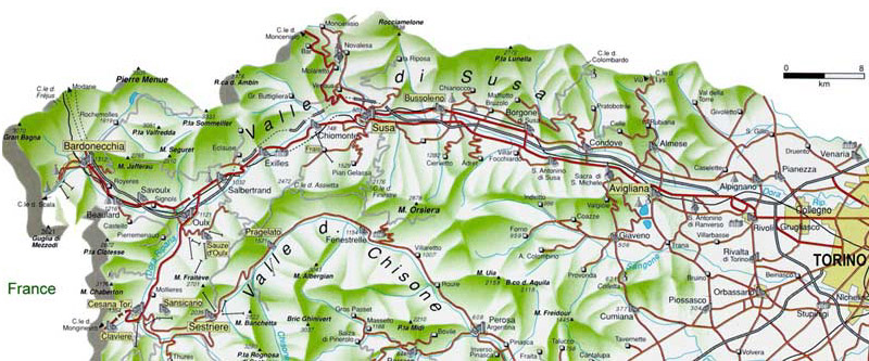
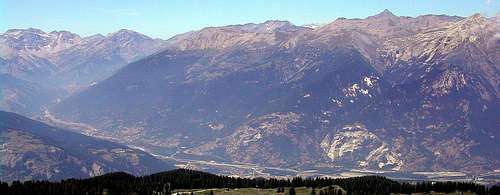
Alpi Cozie settentrionali - overview
Val di Susa in the northernmost valley of Alpi Cozie, a long big valley hosting the most important winter ski resorts of Piemonte.Along its bottom the railway and the highway (A32/E70) of Frejus make it an important traffic artery for commercial interchange with the France.
This valley has been recently known all over the world due to the Winter Olimpic Games 2006
Two mean alpin passes, the Monginevro on the SW side and the Moncenisio on the NW side were (in the last centuries) the main roads between Brianconnes, Savoie and Piemonte (even before the "Italy" was born).
Of course these roads were very important and the valley was a very strategic point for all the local (and not only) wars and struggles ... so you can find there a lot of war structures : forts and fortesses joined by, normally well kept (few of them require a small 4WD), military roads.
Along these roads, normally not closed to private cars, one can gain altitude and usefully save, sometimes, many hundreds of meters of rise: we must just remember that the bottom of the valley is between 300 and 1300 m and the summits grow up to 3500m : the main summit of the valley is the Pierre Menue - 3505m
Many other military roads, too narrow or too exposed for the cars make up a wonderful network system for mountain bikers.
The valley is oriented almost E-W and its main built-up areas (small towns) are Susa (east side), Oulx (at the fork of the valley), Bardonecchia (in the NW side), Cesana (in the SW side)
Its main subvalleys, clockwise starting from S, are:
Valle Argentièra (Valle Ripa) : from Gran Queyron to Cesana
Valle di Thures : from Col di Thures to Bousson
Valle della Piccola Dora : from Montgenevre to Cesana
Valle di Bardonecchia : more than a valley is a big plain wherefrom 2 further valleys grow .. the
Val Cenischia : from Susa to Moncenisio pass
|

PS - I' have considered only the western part of the Val di Susa, omitting the Orsiera-Rocciavrè group (absolutely unknown to me) that starts, toward East, from the Col dell'Assietta and the range starting from Col di Moncenisio toward East (belonging to Alpi Graie).
some personal notes
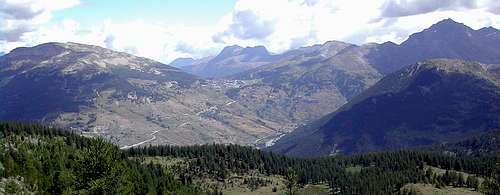
I've spent there 4 summer and 3 winter weeks (in different years) and, even if its summits aren't famous, aren't difficult and aren't appealing I must say that in this valley one can enjoy some very relaxing walks up, hikings and, why not, climbing actions ... even finding one of the finest technical-rock training structure of the western alps.With the exception of Sauze d'Oulx, Bardonecchia and Cesana the valley looks almost desert by tourist traffic so, sometimes, can be a little boring in the bad weather days.
Moving in this valley requires a car even if public tranports are good and go almost everywhere, but their timing is not so useful for mountaneering activities that require, due to the big differences in elevation from the valley to the summit ridges, long days with an early morning start.
Another, not small, problem is, out of the most touristic sites, the lack of info and signs : I have run in almost all the subvalleys and ridges without having any info but giving a look to the map and often I happened to see that the evaluation of the trip was not so exact :)
To enjoy these mountains a good fit and training are required.
So, in a nutshell, out of inhabited centers you look like living in another century (not 19xx but 18xx) and that can be fine
Getting There
this valley has many access points (clockwise from S):Red Tape
No fees required with the exception, of course, of the tolls along the highway and the one (very expensive) for the crossing of Frejus tunnelSome geology notes
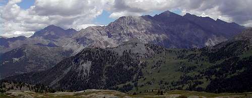
The valley is surrounded, to its western and northern sides, by the main ridge of the Alps, while on its southern side a small, sweet and long ridge, oriented west-east, coming down from the M.Fraiteve and arriving, with wild woody steep slopes, near the plain of Torino : beyond this ridge the Val Chisone whose higher point is the famous Colle del SestriereThe main ridge can be well distinguished in sections, different from each other for their different rocky structure and layers orientations, here you cannot find the typical massive intrusive rock of M.Blanc or Gran Paradiso group.
The relief of the mountains is mainly due to the plication of earth's crust and the landscape has been well shaped by erosion.
So here you can find any kind of rock, from granite to dolostone passing through the various kind of schists.
That means that mountains are normally wild, covered by thick woods in their lower parts, but without big vertical walls and sharp edges in their higher parts : the perfect mountains for a safe old fashion kind of mountaneering and wild hiking.
Main ridges
clockwise, starting from its SW side, we can find :Rognosa del Sestriére ridge
this is a secondary ridge, oriented SSE-NNW, detaching from the main Alps ridge from the Gran Queyron (3060m), and arriving to the Col del Sestriere passing through the main summits of M.Platasse (3149m) and the Rognosa del Sestriere (3280m)this ridge is the eastern border of the Valle d'Argentiera
no refuges in this range, hikes must start from the roads
starting points : Sestriere, Borgata Sestriere - Pattemouche
Roc del Bouchet ridge
another secondary ridge, oriented SSE-NW, detaching from the Punta Ramiere (3303m) passing through the (main) summits of Cima del Pelvo (3236m), the Roc del Bouchet (3285m), the Gran Roc (3120m) and ending to the north, with wooden slopes coming down from the M.Furgon (2816m) over the two built-up areas of Sauze di Cesana and Boussonno refuges in this range, hikes must start from the roads
starting points : Sauze di Cesana - Bousson
Merciantaira ridge
this is the ridge, on the watershed, starting from S with the Punta Merciantaira (3293m) and descending to the Colle di Chabaux (2217m) and the Col de Bousson (2154m) passing through minor reliefsfrom Punta Merciantaira, toward west, the important ridge of the Pic de Rochebrune, the northern border of the Queyras
no refuges in this range, hikes must start from the roads

Monti della Luna ridge
this is a very sweet ridge, on the watershed, starting from the Col de Bousson and ending with the Col of Monginevro (Montegénevre) (1850m)Both sides of this ridge are very sweet, fantastic for mountain biking, sweet walks with the families to the lakes, fine horse riding and, of course, good skiing in winter
fine (useless) refuges here (you can get them along open roads) :
starting points : Bousson - Cesana Torinese

Chaberton ridge
here the watershed grows fast to the Chaberton (3130m) passes through the important summits of the Pointe des Rochers Charnies (3067m), the Pointe of Chalanche Ronde (3042m) (very fine ski-mountaneering summit), the Punta Clotesse (2873m) with its wide rocky bulwark (here 2 fine and not so easy ferrate) going on to the Punta Charra (2843m) bordering to the S the valley of Bardonecchia, then, after some fine but not important reliefs goes down to the Passo della Scala (1762m), better known as Col de l'Echelle.only one refuge in this range : the Rif. Rey, most hikes must start from the roads
starting points : Cesana Torinese - Fenils - Oulx - Beaulard

Vallestretta ridges and ...
Vallestretta is a strange, wonderful valley ... geographically it belongs to Val di Susa, therefore to Italy but politically it now belongs to France (so I had to put that Val di Susa is also a part of France)This valley, the best of the whole area, is bordered by 2 dolomite chains joining at the Mont Thabor (3178m)
Its western border is made of small, low significant reliefs where you can, however, find some fine hike and climb routes, one example is the very popular Guglia Rossa (2548m)
Its eastern border is made of a big dolomite bulwark : the 3 Re Magi with their distinct summits os Punta Gasparre (2808m) - Punta Melchiorre (2948m) and Punta Baldassarre (3155m)
North of the Punta Baldassarre the important summit od Roche Bernaude the highest point of the valley with its 3222m.
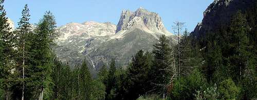
Starting from M.Thabor, a ridge divides the higher part of the valley and ends with the most important (for rock climbers) structure of the area : the Serous (2869m)
Not to be forgotten, in the lower part of the valley, the two very important rock climbing structures :
 | a very solid and massif rocky structure where dozens of well equipped routes (drop up to 350m) look made to keep well trained in all seasons - on this wall you can find both classic and/or modern sport routes  in front of the Parete dei Militi, on the other side of the valley, with its classic difficult rock climbing routes |
offer good hospitality for this range
starting points : Bardonecchia-Melezet
Cima del Vallone ridge
This is the main ridge, on the watershed, bordering to the north the Valley of Bardonecchia.Very wild subvalleys, good for hunters, not important summits with the exception of the Punta Nera (3045m), the Cime du Grand Vallon (3129m) and the Cima del Vallone (3171m) wherefrom, toward south, a ridge comes down dividing Bardonecchia plain from the Rochemolles valley
Only 2 frequented, but no so much, paths toward the ridge : the path to Col della Rho and the one to Col del Frejus
no refuges in this range, hikes must start from the roads
starting point : Bardonecchia
Pierre Menue ridge
The best area for (with safe snow of course) spring ski-mountaneering !The ridge borders to the N the big Rochemolles valley
A road on the bottom of Vallone di Rochemolles, when free of snow, allows to save many hours and the Rifugio Scarfiotti (2160m) is a good starting point for :
the Pierre Menue (3505m) aka Aiguille de Scolette, the highest summit of the described range.
other important and fine summits here (both in spring and summer) are the Gros Peyron (3047m), situated to the East of the Col d'Etache, and the following summits of Cima del Rochers Cornus (3077m), the Rognosa d'Etache (3373m) where you can even find some fine classic rock climbing routes, and, east of the Colle Sommellier (2993m, once there was a summer ski resort) the Pointe Sommellier (3333m)
From these 2 last summits, toward SE, 2 important ridges hosting 2 more fine ski-mountaneering summits : the Punta Valfredda (3051m) and the Cima del Vallonetto (3222m) wherefrom you can start for the finest ski descent of the area : the Valfredda (but only with safe snow !!)
South of the Cima del Vallonetto the ridge comes down to the M.Seguret (2910m) that, from the valley, looks like a very smart summit ... (good hike anyway)
On its S slopes, to be mentioned, the Forte Pramand where you can arrive along a very narrow (better with a 4x4 car) road that starting from the Road of the Grange della Valle leads up to the Jafferau (upper point of the eastern ski resort of Bardonecchia)
Rocca d'Ambin ridge
east of the Punta Sommellier the main ridge goes toward East without important summits till the M.Nible (3365m) than turns toward N with the Pointe Ferrand (3348m) arriving to the Rocca d'Ambin (3378m) and, turning toward NE, arrives to the Dents d'Ambin (3371m) before going down to the Col del Moncenisio, the ending point of Alpi Cozie.These summits are wells served by 2 refuges, easy to be reached,
starting points : Salbertrand - Exilles - Giaglione - Bar Cenisio (the road to Mon Cenisio pass)

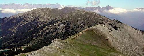
Fraiteve ridge
the last one, the most touristic one, the ridge dividing/joyning the 2 famous ski resorts of Sauze d'Oulx and Sestriére and endin to the Col dell'Assietta.lots of paths, military roads, sweet slopes, woods and meadows, a summit ridge where, almost everywhere you can walk without problems enjoying the 360° panorama of the valley
few summits worth to be mentioned, just the main ones (higher than 2500m) are :
Fraiteve, Triplex, Moncrons, Genevris
starting points : Salbertrand - Sauze d'Oulx - Sestriere
Maps and books
I used the Kompass 109 - Sestriere - Valle di Susa (1:50000) - 1994but cannot consider it a good map, most of the military roads are not marked.
There should better ones edited by IGC , both at 1:50000 and 1:25000
edit : A friend of mine sent to me a good map of the wester area :
ICG 104 - Carta dei sentieri e dei Rifugi - Bardonecchia-Monte Thabor-Sauze d'Oulx - 1:25000
Guide books should exist, but I cannot indicate any of them ...
I hope some can put here more (updated) info