
|
|
Mountain/Rock |
|---|---|
|
|
46.61454°N / 12.91443°E |
|
|
Hiking, Mountaineering, Sport Climbing, Big Wall, Mixed, Scrambling |
|
|
Summer, Fall |
|
|
8822 ft / 2689 m |
|
|
Overview
 On the grassy ridge of Cresta Verde.
Creta di Collina / Kollinspitze, 2689m is a first high mountain above the pass Passo di Monte Croce Carnico / Plöckenpass, 1360m. It is located on the west side of the pass and it is the second mountain before the pass on the west side. Directly above the pass is Creta di Collinetta / Celon / Frischenkofel, 2238m. The mountains belongs to West Carnic Alps Main Ridge. It is on the border between Austria and Italia and located on the main border ridge that comes from the west side from Hohe Warte / Coglians, 2780m, Kellerspitzen / Creta della Chianevate, 2769m and over Creta di Collina continues to the small Creta di Collinetta / Celon / Frischenkofel and then the ridge falls down to the pass.
On the north side of Creta di Collina is a small glacier in the basin of the north face. At the start of the glacier is also a bivouac Eiskar. Around the glacier there are two small peaks Eiskarkopf, 2269m and Gabelekopf, 2289m. The north face of Creta di Collina is almost 1300 meters high. To the east side is Creta di Collina connected with the ridge of Cresta Verde / Grüne Schneid, 2150m and then with is Creta di Collinetta / Celon / Frischenkofel, 2238m. On the south side and southeast there are huge grassy and rocky slopes that falls around 1000 meters below to the plateau Creta Collineta di Sopra. Below the southwest face there is a basin La Cianevate.
 The mighty north face of Creta di Collina / Kollinspitze.
 An alpine jackdaw above Creta di Collina / Kollinspitze.
Creta di Collina is very high mountain, one of the highest in the Carnic Alps. It is not hardly approachable over the S ridge where the normal approach goes. This is a medium hard secured path. The other possibility goes over the east ridge and slopes. This route is a bit harder then the normal approach and it is only marked. There is no iron cables. The route is a climbing route with difficulty UIAA I-II. But for a good climber there is no problem. It is nice to connect the ascent on Creta di Collina with ascent on Creta della Chianevate that is not hardly approachable from the south ridge of Creta di Collina, some meters below the summit. The route is an old milliary path from the First World War. For more details check the page of Creta della Chianevate.
From the summit is a nice view on Carnic Alps, specially on the eastern part. You can see some high mountains of Hohe Tauern and also Julian Alps in the southeast direction.
Getting There
Overview map of the Carnic Alps. Creta di Collinetta / Celon is located on the right side of Hohe Warte / Coglians.
The starting point is the pass Passo di Monte Croce Carnico / Plöckenpass. Here is also a big parking place where you leave your vehicle.
From the North
There are two possible roads:
* From Kitzbühel over B108 through the Felbertauern Tunnel to Lienz, then southeast to Oberdrauburg and Kötschach-Mauthen (B110), where you turn to direction Plöckenpass / Italy.
* From Salzburg along motorway A10 to Spittal. Turn west on B100 to Oberdrauburg, there south to Kötschach-Mauthen were you stay on B110 to the pass Passo di Monte Croce Carnico / Plöckenpass.
From the South (Udine)
Take Motorway A23 to the exit Camia Tolmezzo. Follow SS52 north to Tolmezzo where you turn onto SS52 bis. This leads to the pass Passo di Monte Croce Carnico / Plöckenpass.
 Map of Hohe Warte / Coglians group.
Maps
- Lienzer Dolomiten / Lesachtal
1:50000
Kompass Map WK47
Kompass Verlag
ISBN: 3-85491-053-3
- Tabacco Map, all 1:25000
009 - ALPI CARNICHE / CARNIA CENTRALE
Routes Overview
 On the upper part of east ridge.
There are two main approaches over the marked routes.
 South ridge. A medium hard scured marked route. It starts on the pass Passo di Monte Croce Carnico / Plöckenpass, 1360m. Description. East ridge. A easy climbing route UIAA I-II. It starts from the ridge of Cresta Verde. The route is marked but not secured. Description.
If anyone knows for some climbing route just let me know please.
Red Tape
 An alpine marmot below the north face of Creta di Collina.
There are no speciality. The only thing is that you will walk on the border between Austria and Italia. Though borders have less and less meaning in Europe today, an ID-card should be in your backpack.
When To Climb
The season starts in June and ends by the end of October. But the mountain can be visited also late in year (November, December), in snowless season.Camping and huts
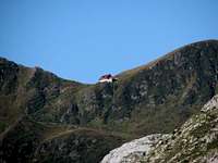 Rif. Marinelli, 2122m.
There is not huts in the nearness. The closest hut is the Rif. Marinelli, 2122m but is along walk to the hut. There are few public houses on the pass Passo di Monte Croce Carnico / Plöckenpass.
For the camping section check the main page of the Carnic Alps or the page of the Western Carnic Alps.
Rif. Marinelli (2111 meters): +39-0433-779177
Weather Conditions
The Carnic Alps Main ridge is a weather divide in northern or southern wind conditions so it pays to keep informed. Look at one of the links below :* Tyrol weather
* Carinthia weather
Thanks to Gangolf Haub for this section.