
-
 4222 Hits
-
 83.69% Score
-
 17 Votes
|
|
Mountain/Rock |
|---|---|
|
|
38.92100°N / 104.9467°W |
|
|
El Paso |
|
|
Hiking |
|
|
Spring, Summer, Fall, Winter |
|
|
9620 ft / 2932 m |
|
|
Overview
UN 9620 has no name, but the summit area gives the mountain a distinctive character. From the top of UN 9620, the hiker can look southwest down a peculiar, flat-topped wall of Pikes Peak Granite. This rock formation shelters from the northwest wind a cozy camping area located just below the summit.The trip to the top of UN 9620 provides an easy but enjoyable scramble over super-grippy rock. Minimal off-trail route-finding makes an outing to the summit of UN 9620 an ideal outing for beginner navigators. Proximity to the Colorado Springs metro area makes this a quick, pleasant outing that can be completed at casual pace. The top of UN 9620 would be an excellent place for hauling up a lavish picnic lunch and enjoying the views.
 UN 9620: Final approach to the summit
04 Apr 2009
Colorado Rank: 2535th highest mountain in Colorado
Prominence: 320 feet
Mountain Range: Front Range
USGS Quad: Cascade
Trails Illustrated Map: #137 (Pikes Peak, Cañon City)
Rank and Prominence Reference:Lists of John
Getting There
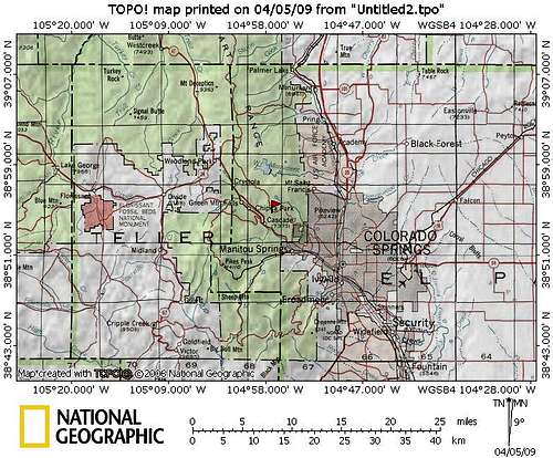 Click map image to enlarge
 Rampart Range Road is narrow, rutted and busy.
04 Apr 2009
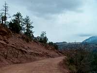 Rampart Range Road driving conditions
04 Apr 2009
UN 9620 rises a half mile east-northeast of Rampart Range Road, about halfway between Colorado Springs and Woodland Park. Rampart Range Road, built during the Great Depression by the Civilian Conservation Corps, is a maintained dirt road that, in dry conditions, is accessible to most passenger cars. However, high clearance is recommend (even in dry conditions) and in wet or snowy conditions, only 4x4s should venture up Rampart Range Road. This area is served by Randy’s High Country Towing, regionally famous for extracting the vehicles of folks who got in over their heads on Pikes Peak area backroads.
Be forewarned that Rampart Range Road is bedeviled by irresponsible, speeding, out of control drivers. Combine this behavior with narrow, wash-boarded dirt roads and your worst objective hazard of the day becomes other drivers and their vehicles. Drive defensively on this road!
Red Tape
There is very little red tape in this part of the Pike National Forest.- Do not litter and dispose properly of human waste.
- Much of Rampart Range Road is a “no shoot” zone. That means: Shoot only in designated target ranges.
- Operate motor vehicles only on designated roadways.
- For everyone’s safety, the National Forest officials segregate street legal, licensed motor vehicle traffic from OHV traffic. Adhere to posted placards managing this traffic. (In plain English: Keep your Jeep off the trails and keep your dirt bike / quad runner off the roads.)
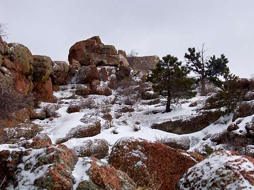
 UN 9620: Summit area
04 Apr 2009
Camping & Lodging
National Forest Campsites
Rustic car camping and backcountry camping can be found in the adjacent Pike National Forest. Be forewarned that the proximity of this area to the urban I-25 corridor means that crowding can be an issue, especially in the summer, and that unsavory characters are known to frequent this area. Be prepared for heavy ATV use, large crowds, drunkenness and casual firearms usage.
The nearest semi-developed US Forest Service campsites would be in the Rampart Reservoir area.
Meadow Ridge Campground:
- 19 campsites
- 9,200 feet elevation
- Season: Generally early May through September
- $15 per night, per site
- Amenities include tables, fire grates, drinking water, latrines, and trash collection
- 21 campsites
- 9,200 feet elevation
- Season: Generally early May through September
- $15 per night, per site
- Amenities include tables, fire grates, drinking water, latrines, and trash collection
 UN 9620: Looking southwest away from the summit UN 9620: Looking southwest away from the summit04 Apr 2009 |  UN 9620: Looking north-northeast UN 9620: Looking north-northeast04 Apr 2009 |  UN 9620: Outcrop UN 9620: Outcrop04 Apr 2009 |
Hotels
Manitou Springs
Manitou Springs lies at the foot of Ute Pass. The Barr Trail trailhead lies within this community This colorful, eclectic town offers a wide range of lodging options including old-style motor cottages and cabins, retro family-run motels, charming B&Bs and modern chain hotels. Shopping and dining are within walking distance of most Manitou lodging. Visit the a href=http://www.manitousprings.org/Default.aspx >Manitou Springs Visitors Website for more information on lodging in the area.
Colorado Springs
The hotel options in Colorado Springs are virtually limitless. If you are the 5-star luxury type, be sure to check out The Broadmoor.
Weather & Seasons
Due to relatively low altitude, UN 9620 is a reasonable year-round summit objective.Winter & Spring: The snow season is a delightful time to visit UN 9620. The crowds are sparse and the moisture keeps the dust to a minimum. However, a deep snow will make Rampart Range Road impassible.
Summer & Fall: In the summer and into the fall (before the first big snow) this area can be hot, dusty, noisy and crowded. Visiting early in the morning or in the middle of the week will mitigate these issues.