


-
 2983 Hits
-
 79.78% Score
-
 11 Votes
|
|
Area/Range |
|---|---|
|
|
45.64420°N / 7.38713°E |
|
|
Hiking, Mountaineering, Trad Climbing |
|
|
Spring, Summer, Fall, Winter |
|
|
11532 ft / 3515 m |
|
|
Note
La montagna chiama i suoi figli, ed essi rispondono fedelmente al suo appello… Osvaldo Cardellina, Diario alpinistico, 1964-65 Page texts: @ OsvaldoCardellina "Osva", passed away on May 2, 2022. Page owners: Christian Cardellina e Osvaldo Cardellina. Any updates from September 12, 2022: Antonio Giani, page administrator, friend and climbing companion. Testi della pagina: @ OsvaldoCardellina "Osva", scomparso il 2 maggio 2022. Proprietari pagina: Christian Cardellina e Osvaldo Cardellina. Eventuali aggiornamenti dal 12 settembre 2022: Antonio Giani, amministratore della pagina, amico e compagno di salite. |
Overview
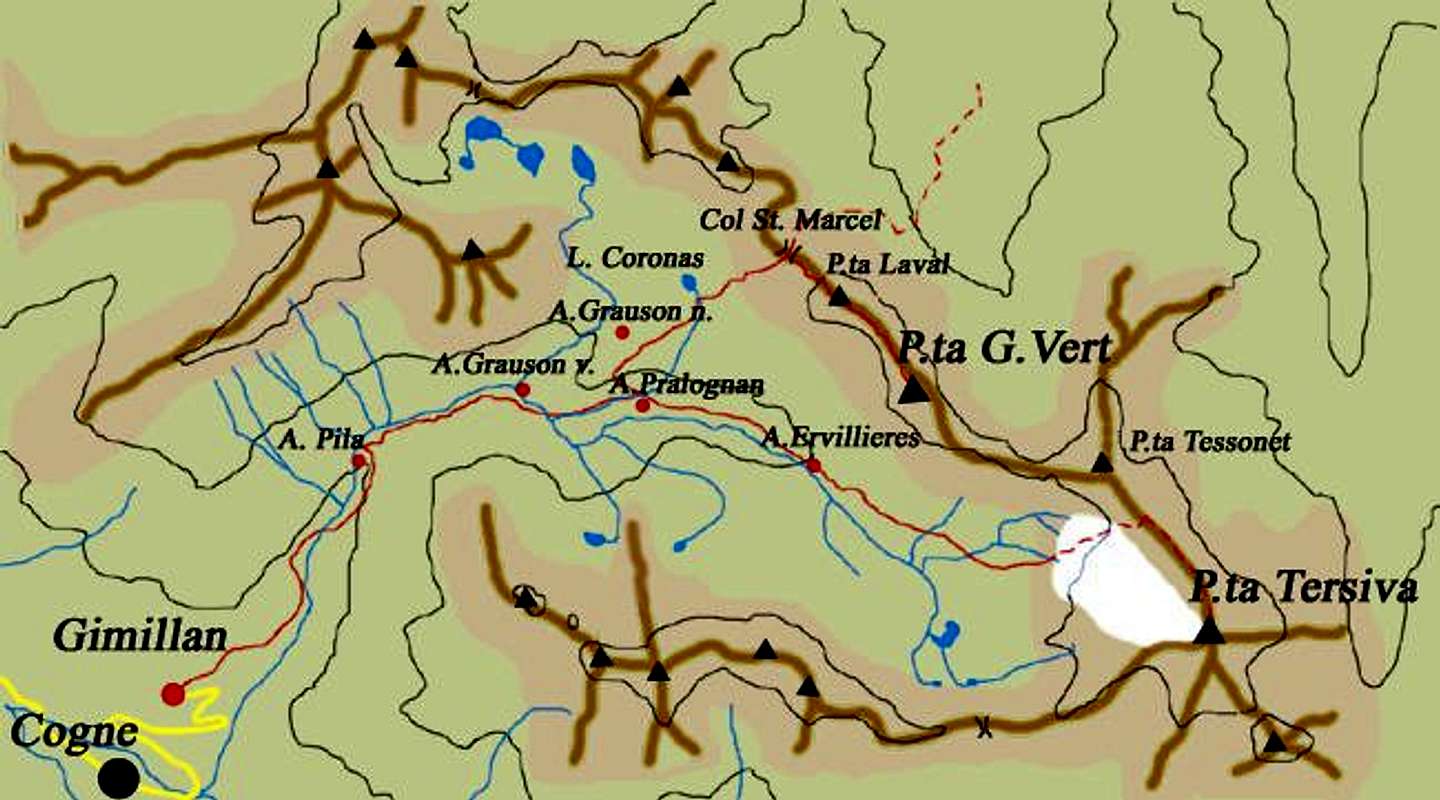
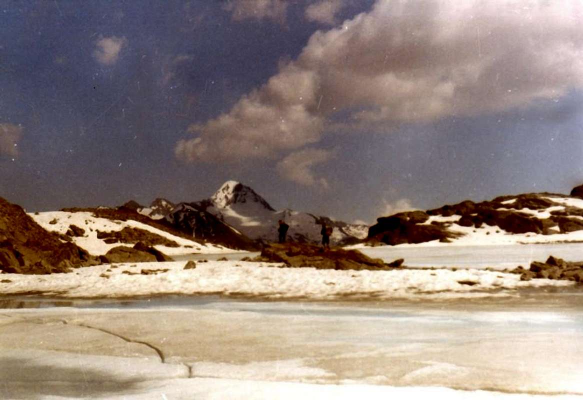
Great, Gru, Grand or Grauson? Actually this valley, which opens immediately behind the Village Gimillan above the Common of Cogne, derives its name from the characteristic of being as long as it extended. Place on the axis South / North, after an initial part represented by the erosion of Stream Gru, which takes its name, for this reason, the meeting of Torrents de Lussert, Corona and Doreire, spreads like a big leaf in which You can distinguish three specific areas and starting from the West:
1) - the area of the Lakes Lussert that flexing in Northwest reaches the Pas du Valaisan and Col des Laures.
2) - the central zone (here shown in the photo) that reaches the Punta di Leppe and the Hill of St. Marcel.
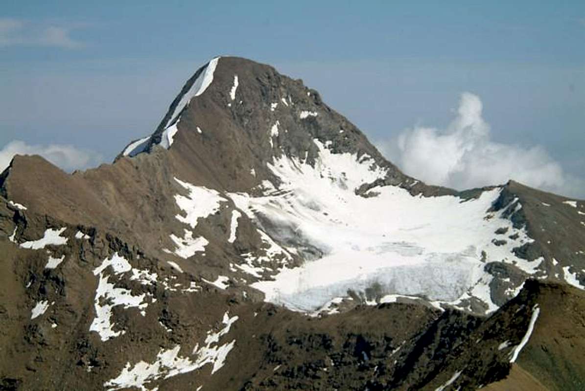
3) - branching to the right or Eastward to Punta Tersiva and Pass Invergneux.
![]()
Grande, Grosso, Gru o Grauson? In realtà questo vallone, che si apre subito alle spalle del Villaggio di Gimillan sopra l'abitato di Cogne, deriva il suo nome dalla caratteristica d'esser tanto lungo quanto esteso. Posto sull'asse Sud/Nord, dopo una parte iniziale rappresentata dall'erosione del Torrent Gru, che, proprio per questo motivo, prende il suo nome dalla riunione dei Torrents de Lussert, Corona e Doreire, si allarga a guisa di grande foglia nella quale si posson distinguere tre precisi settorie e partendo da Ovest:
1) - il settore dei Laghi di Lussert che flettendo a Nordovest raggiunge il Pas du Valaisan ed il Col des Laures.
2) - la zona centrale (qui evidenziato dalla foto) che raggiunge la Punta di Leppe ed il Colle di St. Marcel.
3) - la ramificazione verso destra od Orientale verso la Punta Tersiva ed il Pas d'Invergneux.
![]()
Getting There
BY CAR:
- From TORINO, MILANO, etc: Motorway A5. Exit at IVREA or Quincinetto (PIEDMONT) AOSTA West/Aymavilles, Cogne Municipalities. From Aymavilles (646m) towards Cogne Valley: reacging Vieyes (1.132m), Epinel, Crétaz Hamlets to Cogne (1.534m); through Main Road. From this by Regional Road towards montroz and Gimillan (1.785m) Villages; from the last towards the above Grauson Vallon.
- From FRANCE: through the Mont Blanc Tunnel to Entrèves-crossroads to Vény/Ferret Valleys - Mountain Guides of Courmayeur - La Saxe Rock Gym - Courmayeur. By Little Saint Bernard Hill, closed since November until half May to La Thuile Valley - Pré Saint Didier - Courmayeur. It is not necessary to take Motorway A5: you can drive on SS.26, in the direction of AOSTA - IVREA - TURIN.
BY PLANE:
- Aeroporto "Corrado Gex" Saint Christophe (Aosta).
 |
 |
 |
 |
 |
A dozen Recommended Routes to the interior of the Valley of Grauson
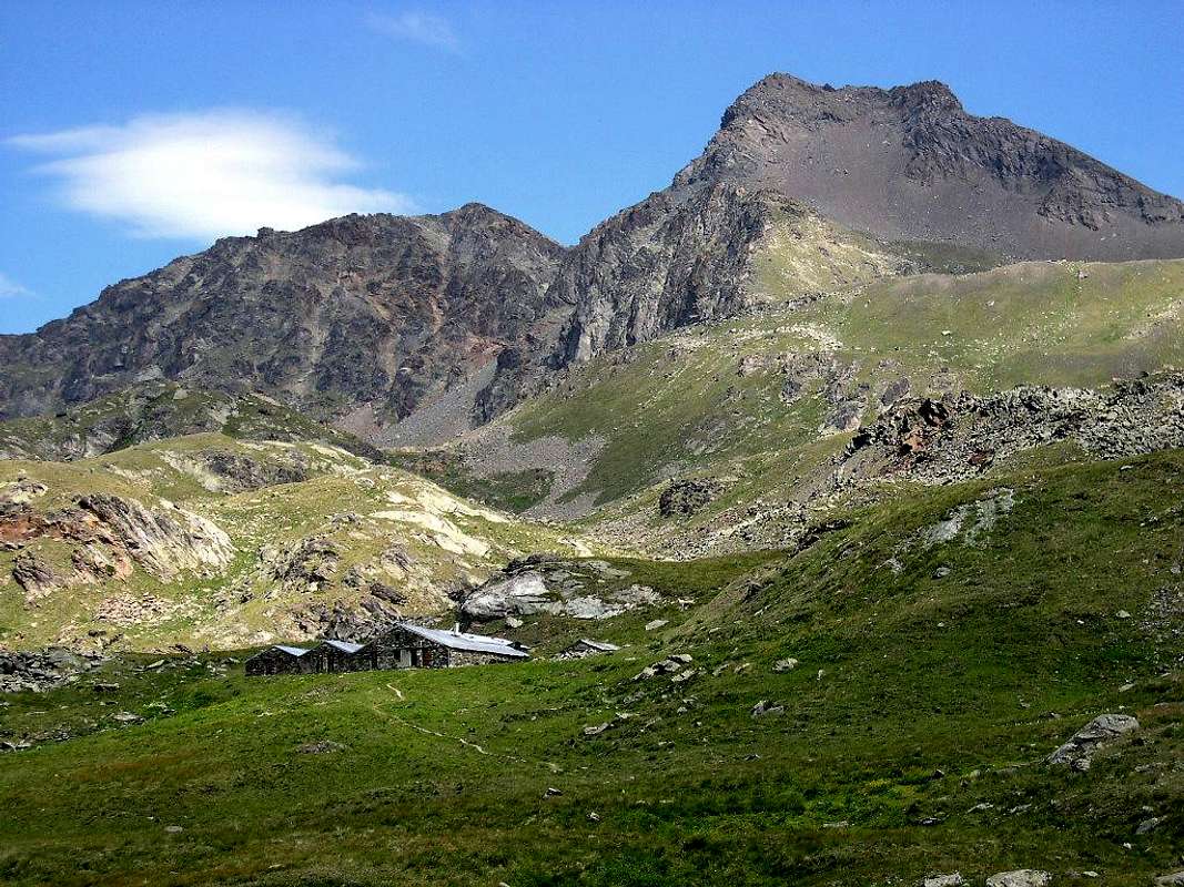
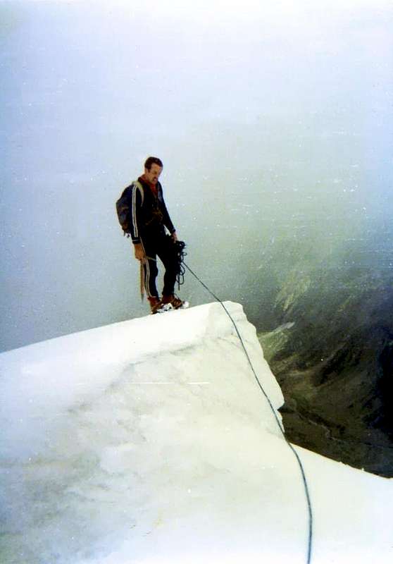
Starting from the Northwest, the entrance of the Valley, and continuing clockwise, after the appendices on the watershed Punta de la Pierre/Punta Valletta (see Pila Basin), we find the first great valley above the Village Gimillan. This opens up, like a large canopy tree, sending a first branch in the Northwest into the valley below Arpisson which in turn "gives birth" a smaller one on its edges towards the East Hill of Tsa Sètze. The main branch or North up towards the Pian di Bessey, Bivouac, Lake Garin and namesake hill below the pyramid Pic Garin forming the Vallon of Arpisson. This area offers climbing, hiking, walking and two equipped routes. The third branch opens more towards forming the Northeast Vallon of Grauson: this also doubles sending a large area to the West in the direction of the other Lakes Lussert and from Passes Valaisan and des Laures, at the foot of a basin consists Tour Grauson, Pic Garin, Punta Rossa, Punta and Mont des Laures. A smaller section and "crushed" is aimed first at North-northeast and then East to the Lower Lake Lussert, the eponymous Punta, Punta di Leppe from which descends the watershed with the Valley of Saint Marcel. The same form sloping Col Vallonet, Mont Vallonet, the two Summits of Laval and Punta Gianni Vert. A marked collar, said the Tessonet, gets up its cape and then "run" towards Tessonet coastline, Tersiva Pass and Punta Tersiva (3.515m), the highest of all this great area. The Southern edge of the same is formed by small Soubgroup of Penne Blanche (Testa Vallonet, the two Penne Blanche Eastern and Western, Punta Coupée, Testa of Money and Mont Creya) from Pas d'Invergneux or des Hevergnes reach Mount Creya with its fine Loadstonemines.
![]()

The Vallons most important & the recommended Excursions
1) - Pila Alp and Waterfall (2.221m, 2.250): walk from Gimillian (1.788m) with path n° 8/TVC in Northeast before towards Tarabouc, Révènti ruines and Tchezeu/Ecloseurs Alps (1.903m), after in North over Grua Torrent through a small deviation not reported and unnumbered to the Pila and nearby waterfall (2.021m) (E/F; 1h'20/1h'40).
2) - Ecloseur, Pila, Grauson Vieux and Nuove Alps, Lussert three Lakes (1.787m, 2.273m, 2.540, 2.713m, 2.790m, 2.906m), Laures Hill (3.305m): long excursion from Gimillian with various paths n° 8/TVC before in North, after in Northwest along Grua and Lussert Torrents with trail n° 8/TVC/8A/102 (EE/F; 5h'00/5h'30).
3) - Gimillan towards Grauson Vieux and Nuove: (2.273m, 2.540m) through previous paths, after in West pathless but through moraines to Valaisan Pass and Mont Valaisan (3.210m, 3.307m) by North-northeast Crest and traverse to Pic Garin (3.451m) climbing by North-northwest Ridge and North Edge (A/F+/PD-; 8h'00/8h'30).
4) - Grauson Nuove, Valaisan Pass (2.500m, 3.210m), Western Punta Rossa (3.401m): easily climbing through South-southwest Crest (E/E/A/F+; 7h'00/7h'15).
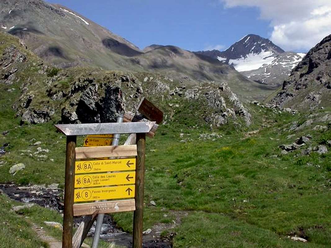
5) - Ecloseur, Pila, Grauson Vieux and Nuove Alps, Frog's and Corona Lakes (1.903m, 2.221m, 2.273m, 2.500, 2.641m, 2.702m), Saint Marcel Hill (2.913m): excursion from Gimillan with various paths n° 8/TVC/8A/102 before in North, after by Grauson Nuove in East-northeast with trail n° 8B/102 (E/F; 4h'00/4h'30).
6) - Gimillan to St. Marcel Hill (2.913m): excursion-climbing from hill in North to two Laval Summits and Punta Gianni Vert (3.091m, 3.099m, 3.150m) (E/F; 5h'30/6h'00).
![]()
7) - Grauson Nuove and Tsezéire Alps, Vallonet Pass (2.540, 2.645m, 3.062m) to Punta di Leppe (3.305m): excursion-climbing from Gimillian with various trails n° 8/TVC/8A/102 before in North, after in Northeast with path unreported to Western Slope of pass and East-southeast Crest in terminal part (EE/F; 5h'00/5h'30).
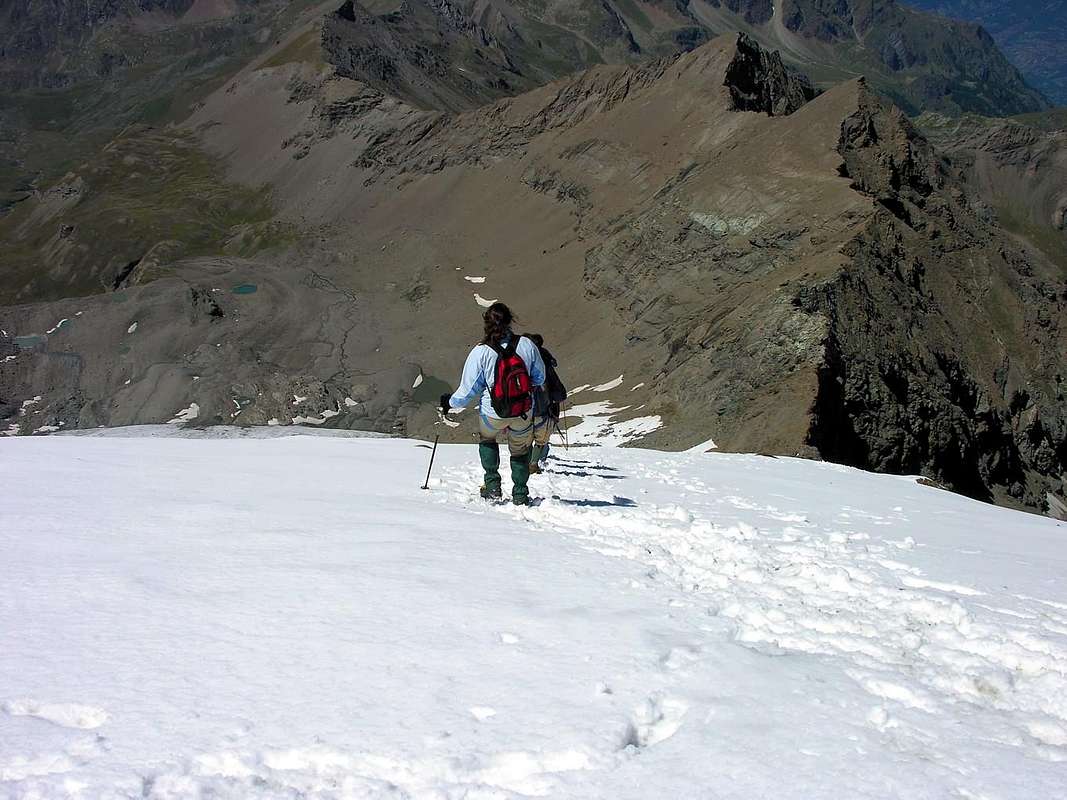
8) - Grauson Vieux, Pralognan and Ervillières Alps, (2.273m, 2.416, 2.515m): long excursion-climbing from Gimillian with various paths n° 8/TVC before in Northeast, after in East along Lussert-Grauson-Doreire Torrents with the same path towards Pralognan and Ervillères Pastures; continue beyond the same up to the fork about 2.600 meters neighboring the Doreire Torrent. Finally crossing wide moraines with noumerous ponds and Tessonet Glacier on Northern margins to Tersiva Pass (3.310m) through a small and steep track on debris in West Slope. From the "Collar", turning South, through the easy North-northwest Ridge in terminal part to Summit (A/F+; 6h'00/7h'00).
9) - Ecloseur, Pila, Créuzet Alps, Money Lake, Monte Creya (1.903m, 2.221m, 2.244m, 2.550, 3.015m): excursion from Gimillian with various paths before in North-northeast by previous trail, after in Southeast with small path 8C to Money Lake and final part on grassy North Slope with small unnumbered path (EE/F; 4h'00/4h'30).
10) - Ecloseur Alp, Larsinaz Loadstone Mines (1.903m, 1.899m): walk from Gimillian with path n° 8/TVC before in North-northeast towards Ecloseur tiny Chapel up to the small wooden bridge above Gru Torrent nearby Ecloseur Pastures, after South-southheast through path n° 8D to old Minershouse of Magnetitemine (T/F; 1h'30/1h'45).
11) - Montroz Village, Larsinaz Loadstone Mines, Plan de Mont Salet collar (1.702m, 1.899m, 2.301m): excursion from Montroz with path n° 9 in East-southeast or by Gimillan through the previous trail before in North-northeast up to Ecloseur Pasture, after in South-southeast towards the Plan de Mont Salet, neighboring Costa del Pino veins, with path n° 8D. From this point with path n° 9 in East to Colonna Mines and finally in North n° 5 to Liconi Magnetitemine (2.390m, 2.495m) (E/F; 2h'30/3h'00).
12) - Montroz Village, Costa del Pino Loadstone Vein (1.702m, 2.026m): tourist walk from Montroz small Hamlet below Gimillan Cogne's Fraction, crossing the Gru Stream through the small bridge in altitude of 1.672 meters nearby the little Chapel in winding road before the same, with dirt road concomitant with the path n° 9 or through the above unnumbered path, both always up to the junction 1.810 meters and from this in Eastnortheast to Costa del Pino Mines, just in West by Colonna (T/F; 1h'20/1h'40).
![]()
![]()
![]()
![]()
![]()
Partendo da Nordovest, all'ingresso della Valle, e continuando in senso orario, dopo le appendici sullo spartiacque tra la Punta de la Pierre e la Punta della Valletta (vedi Pila Basin), troviamo il primo grande vallone sopra il Villaggio di Gimillan. Questo s'apre, a guisa di grande chioma d'albero, inviando un primo ramo a Nordovest verso il Vallone di Arpisson che, a sua volta ne "partorisce" uno più piccolo ai suoi margini Orientali verso il Colle di Tsa Sètze. Il ramo principale o Settentrionale sale verso il Pian di Bessey, Bivacco, Lago Garin ed omonimo Colle al di sotto della piramide del Pic Garin (3.451 m), formando il Vallone d'Arpisson. Quest'area offre ascensioni, escursioni, passeggiate e due vie non da molto tempo attrezzate. Il terzo ramo s'apre maggiormente verso Nordest costituendo il Vallone del Grauson: anche questo a sua volta si sdoppia inviando un ampio settore verso Ovest in direzione degli altri Laghi del Lussert e verso i Passi di Valaisan e des Laures, ai piedi d'un bacino composto da Tour Grauson, Pic Garin, Punta Rossa, Punta e Mont des Laures. Una sezione più ridotta e "schiacciata" si rivolge prima a Nord-nordest e poi ad Est verso il Lago Inferiore di Lussert, l'omonima Punta, la Punta di Leppe dalla quale scende lo spartiacque con il Vallone di Saint Marcel. Lo stesso forma digradando il Col e Mont Vallonet, le due Punte di Laval e la Gianni Vert. Un marcato colletto, detto del Tessonet, si rialza all'omonima Punta per poi "correre" verso la Punta Tersiva (3.515 m), la più elevata e conosciuta di tutta questa grande area. Il bordo Meridionale della stessa é costituito dal piccolo Sottogruppo dei Penne Blanche (Testa di Vallonet, Penne Blanche Orientale ed Occidentale, Pointe Coupée e Testa di Money) che dal Passo d'Invergneux o des Hevergnes raggiunge il Monte Creya (3.015 m) con le sue pregiate Miniere di magnetite nei Filoni di Larsinaz, Costa del Pino, Colonna e Liconi.
The most important Summits of Grauson
Summits of Tersiva, Garin, Rossa, Laures, Valaisan, Leppe, Tessonet, Penne Blanche or Grauson and d'Arpisson Towers? Or and still Pointe Fleurie (3.258m), Punta Lussert or triple Pointes Coupées of Arpisson (3.231m) that someone still insists on calling "Tips Coppi", that few know and many do not even know where they are, including the inhabitants of Gimillan Village. Or Gianni Vert (3.150m), which everyone knows, but no one, including me, knows where the stems that exact name. Not an easy choice to assert supremacy. Even in the mountains. Already Punta Tersiva (3.515m) see all from the top, while the Pic Garin (3.451m) lowers his head, almost resigned to being identified as the "eternal second", even though, driven by a surge of pride, look, stone by stone to climb up the table. The other, now eternally "lying" in the role of supporting cast, flaunt indifference, but also a bit of jealousy. The Punta Rossa of the Emilius with its three elevations (3.401m, 3.295m, 3.400m) consoles himself with plenty to be triple, while the Pointe des Laures (3.367m), knows for sure that will be the shoulder for ever the same, so as the other side of the Mont Valaisan (3.307m) with Garin. The Leppe (3.305m) almost walks away with the Valley of Saint Marcel and nearby Pointe de Lussert (3.221m) disconsolately ignored and abandoned, with the des Laures. While Tessonet (3.266m) is satisfied to be the shadow of the "Queen" Tersiva. The Tour Grauson (3.233 or 40 meters?) distances to the East from Garin which knows to be most feared and respected, while the Penne Blanche (3.248m) disappears in the South, as if to make the most important Group in the Gran Paradiso, opening its wings to the East towards the Pas d'Invergneux or des Hevergnes (2.902m) and to the West on Creya (3.015m), very small but "master & owner" of all the Mines of Cogne. We say all this, but keep the "Rank of Nobility" according to their height and with this policy we propose the Top Ten of all these mountains. But if you want you can even change ...

Tersiva, Garin, Rossa, Laures, Valaisan, Leppe, Tessonet, Penne Blanche oppure Tour Grauson o d'Arpisson? Oppure ed ancora Pointe Fleurie (3.258 m), Punta di Lussert o le triplici Pointes Coupées d'Arpisson (3.231 m) che qualcuno si ostina ancora a chiamare "Punte Coppi", che pochi conoscono e molti non sanno neppure dove si trovano, compresi gli abitanti di Gimillan. O la Gianni Vert (3.150 m), che tutti conoscono, ma che nessuno, io compreso, sà da dove le derivi quel preciso nome. Una scelta non facile quella di affermare una supremazia. Anche tra le montagne. Già la Tersiva (3.515 m) guarda tutti dall'alto, mentre il Pic Garin (3.451 m) abbassa la testa, quasi rassegnato ad esser individuato qual l'"eterno secondo", anche se poi, mosso da un'impennata d'orgoglio, cerca, pietra su pietra di risalire in classifica. Le altre, ormai eternamente "adagiate" nel ruolo di comprimarie, ostentano indifferenza, ma anche un pò di gelosia. La Punta Rossa con le sue tre elevazioni (3.401 m, 3.295 m, 3400 m) si consola con l'abbondanza d'esser tripla, mentre la Pointe des Laures (3.367 m) sà per certo che farà da spalla in eterno alla medesima, così come dall'altra parte il Mont Valaisan (3.307 m) con la Garin. La Leppe (3.305 m) quasi se ne và col Vallone di Saint Marcel e la vicina Lussert (3.221 m) sconsolatamente ignorata ed abbandonata, con quello des Laures. Mentre il Tessonet (3.266 m) si accontenta d'esser l'ombra della "Regina" Tersiva. La Tour Grauson (3.233 o 40 metri?) prende le distanze ad Oriente dalla Garin della quale sà di essere più temuta e rispettata, mentre il Penne Blanche (3.248 m) si eclissa a Mezzogiorno, quasi volesse fare parte del più importante Gruppo del Gran Paradiso, aprendo le sue ali ad Est verso il Pas des Hevergnes (2.902 m) ed ad Ovest sul Creya (3.015 m), piccolino ma "padrone" di tutte le miniere di Cogne. Noi diciamo tutte queste, ma manteniamo il "Rango di Nobiltà" in base alla loro altezza e con questo Criterio proponiamo la Top Ten di tutte queste Montagne. Ma se volete potete anche cambiare ...
From Lakes towards the Passes
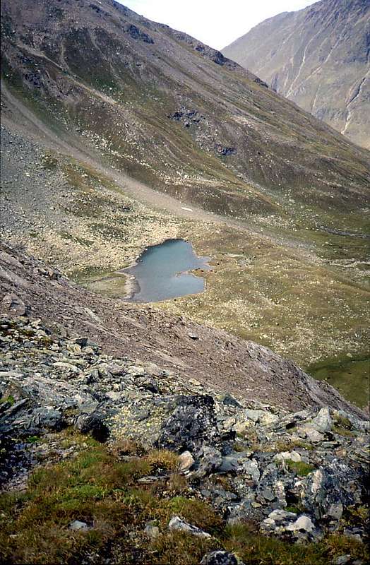
But in this zone there are also in addition to barren and desolated mountains even lakes? Certainly, in fact, together with the above hills are definitely the busiest areas. By Hikers and Fishermen. Because the same immediately North of Cogne and Gran Paradiso is more exposed to the sun and therefore its ice before they withdrew. Giving birth to a series of beautiful lakes, continuosly changing colors and, rightly, very popular. The same are subject to a number of important parcels in communications with the other valleys, as well as known and popular "ab immemorabilis" or from a remote time, not calculated by memory. Let's see what these describing counter-clockwise:
13) - Lake of Money (2.550m) located in the Northern foothills of the Tête de Money (3.130m) is reached with the route of Mount Creya (see n° 9; E/F; 2h'00/2h'30).
14) - Lake of Testa or Tz'te (2.753m), sited in the South of the promontory called Puy de Vardettaz (2.574m) is reached by the itinerary of Lake Money and with a wide circle first in the Northeast and then, passing the same, through a grassy gully-detrital with path decisively towards the South (see above N° 13; EE/F; 2h'30/3h'00).
15/16) - Lakes Doreire and Pas d'Invergneux or Hevergnes (2.734m, 2.774m, 2.844m, 2.922m) can be reached with the path to Tersiva (3.515m) to the junction at about 2.600 meters near Torrent Doreire and then continuing with the same path, but more to the South-southeast in the midst of three lakes (see n° 8; E/F; 4h'00/4h'30).
17) - Ponds of Punta Tersiva and "Collar" of Tessonet (on average between 2.750 and 2.950 meters and 3.051/66m), located at the Southern foot of Punta del Tessonet (3.266m) and at the base of the Northwest Face of Tersiva, can be reached by partial route to the same and finally climbing the hill, located between Tessonet and Punta Gianni Vert (3.150m), to the North by steep moraine and overcoming a rocky strip with short passages of I°/II° (see in part N° 8; EEA/F+/PD/PD+; 4h'15/4h'45).
![]()

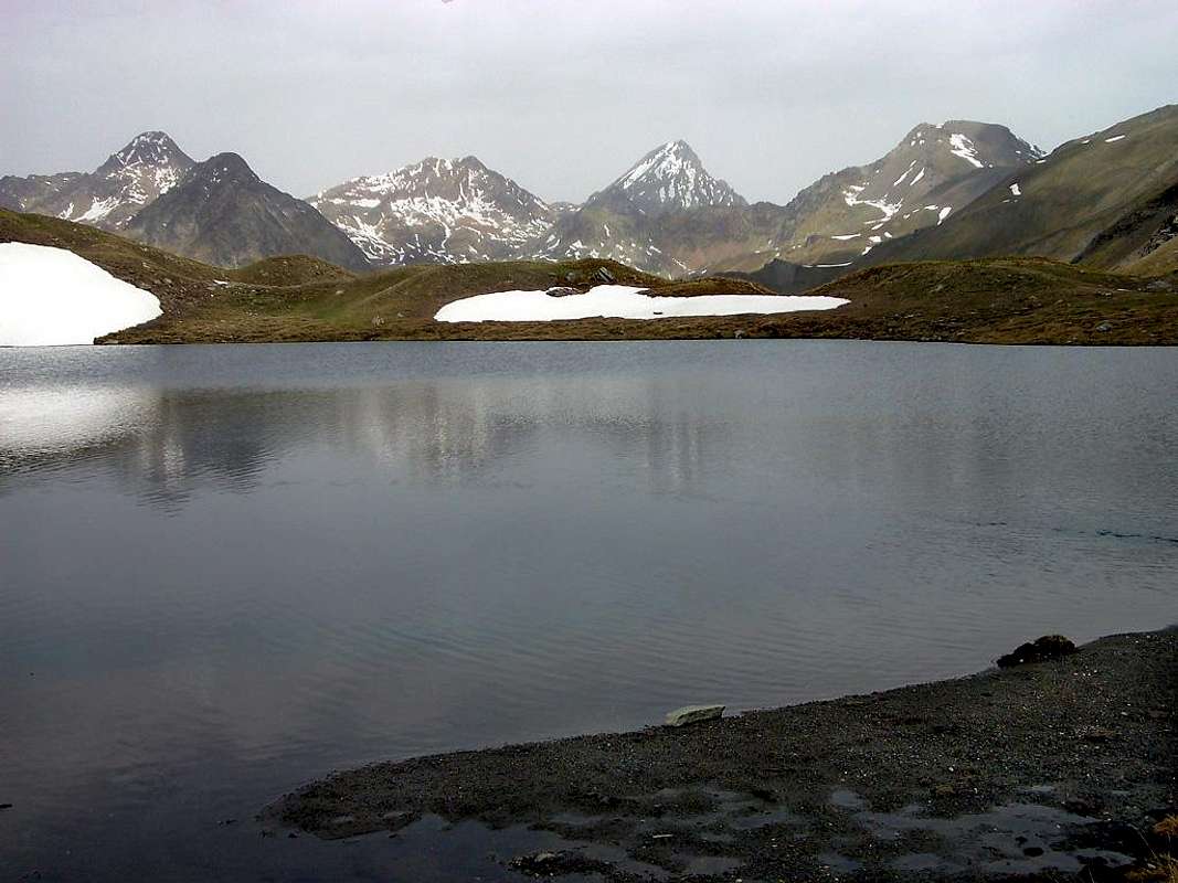
18/19/20) - "Frog's" and Corona Lakes and St. Marcel even called Coronas Hill, collocated in the more central part (2.641m, 2.702m, 2.913m), reached from Gimillian with various paths in North-northeast (see n° 5; E/F; 4h'00/4h'30). Also from the upper Lake Corona connectivity with the trail currently under construction and not numbered, by the above in North-northwest "Collar" 2.705 meters about with the Lower Lake Lussert, part of the next route (see n° 7; E/F; 0h'45/1h'00 lake to lake).
21) - Col Vallonet (3.062m), on the Southern slopes of Punta di Leppe (3.305/6m) and at the beginning of his South-southeast ridge or Normal Route, is reached by the itinerary of Lake Corona and by traces of path is not marked and unnumbered into above small vallon to the Northeast (see above n° 18/19/20; E/F; 4h'00/4h'30).
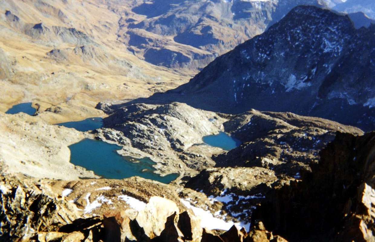
22/23) - Lussert three Lakes (Lower, Middle and Upper) and Laures Hill, reached by Gimillan Hamlet (1.787m, 2.273m, 2.540m, 2.713m, 2.790m, 2.906m, 3.305m) through a long excursion in North-nortwest with various paths passing Ecloseur narrowing and Grauson Vieux and New Pastures (see above n° 2; EE/F; 5h'00/5h'30).
24/25) - Lussert Upper and Highest Lochs towards Valaisan Pass (2.906m, 2.923m, 3.210m) through previous route; from Upper before in South to the plateau with the Lago Alto". After from this last, flexing gradually more to the West, pathless but always through moraines towards the Valaisan Pass (see n° 4; EE/F; 6h'30/7h'00).
![]()
![]()
![]()
Ma in quest'area di montagne un pò sterili di ghiacci e desolate esistono anche dei laghi? Certamente, anzi, insieme ai soprastanti colli son sicuramente le zone più frequentate. Da escursionisti e Pescatori. Proprio perché questa zona subito a Settentrione di Cogne e del Gran Paradiso risulta più esposta al sole e quindi gli stessi prima si son ritirati. Facendo nascere una serie di bellissimi laghi, dai colori continuamenti cangianti e, giustamente, molto frequentati. Gli stessi sottostanno ad una serie di colli importanti nelle comunicazioni con gli altri valloni, nonché conosciuti e frequentati "ab immemorabilis". Vediamo quali son quest'ultimi descrivendoli in senso antiorario: 13) Lago di Money (2.550 m), posto alle pendici Nord della Tête de Money (3.130 m) si raggiunge con l'itinerario del Monte Creya (vedi sopra n°9; E/F; 2h'00/2h'30). 14) Lago di Testa o Tzte (2.753 m), collocato a Sud del promontorio chiamato Puy de Vardettaz (2.574 m) si raggiunge con lo itinerario del Lago di Money e con un largo giro dapprima a Nordest e poi, oltrepassato il medesimo, tramite un canalone erboso-detritico con percorso decisamente a Mezzogiorno (vedi n°13; EE/F; 2h'30/3h'00). 15/16) Laghi Doreire e Pas d'invergneux o des Hevergnes (2.734 m, 2.774 m, 2.844 m, 2.922) si raggiungono con la via per la Punta Tersiva (3.515 m) fino al bivio 2.600 metri circa presso il Torrent Doreire e poi continuando con lo stesso sentiero ma maggiormente verso Sud-sudest in mezzo ai tre laghi (vedi sopra n°8; E/F; 4h'00/4h'30). 17) Laghetti della Punta Tersiva e "Colletto" del Tessonet (mediamente tra i 2.750 e 2.950 metri e 3.051/66 m), posti alle pendici Meridionali della Punta del Tessonet (3.266 m) ed ai piedi della Punta Tersiva, si raggiungono con parziale itinerario verso la medesima e salendo infine al colle, posto tra la Punta del Tessonet e la Punta Gianni Vert (3.150 m), verso Settentrione tramite ripida morena e superando una fascia rocciosa con brevi passaggi di I°/II° (vedi in parte n°8; EEA/F+/PD/PD+; 4h'15/4h'45).
18/19/20)- Laghi "delle Rane" e Corona e Colle di Saint Marcel od anche detto di Coronas, collocati nel settore maggiormente centrale (2.641 m, 2.702 m, 2.913 m), raggiungibili da Gimillian tramite il collegamento di vari sentieri (vedi n°5; E/F; 4h'00/4h'30). Inoltre dal Lago Corona possibilità di connessione con il sentiero attualmente non numerato ed in allestimento, tramite il soprastante a Nord-nordovest Colletto 2.705 metri circa con il Lago Inferiore di Lussert facente parte del prossimo itinerario. 21) Col Vallonet (3.062 m), posto alle pendici Meridionali della Punta di Leppe (3.305/6 m) ed allo inizio della sua Cresta Sud-sudest o Via Normale, si raggiunge con l'itinerario del Lago Corona e tramite tracce evidenti di sentiero non segnalato e non numerato in un soprastante valloncello a Nordest (vedi sopra n°18/19/20; E/F; 4h'00/4h'30). 22/23) Laghi del Lussert (Inferiore, Medio e Superiore) e Col des Laures, raggiungibili dal villaggio di Gimillan (1.787 m, 2.273 m, 2.540 m, 2.713 m, 2.790 m, 2.906 m, 3.305 m) con lunga escursione a Nord-nordovest con vari sentieri e passando la strettoia dell'Ecloseur per Grauson Vieux e Nuove (vedi sopra n°2; EE/F; 5h'00/5h'30). 24/25) Laghi Lussert Superiore ed "Alto" e Pas du Valaisan (2.906, 2.923, 3.210 m) con la via precedente dal Lago Superiore dapprima verso Sud al plateau con il Lago Alto". Quindi da quest'ultimo, flettendo gradualmente ad Ovest, senza sentiero ma sempre su morene in direzione del Pas du Valaisan (vedi n°4; EE/F; 6h'30/7h'00).
Campings
Remember that free camping is forbidden (except for emergency reasons, over 2.500m, from darkness until dawn).Mountain Condition
- Meteo: you can find all the needed informations at the official site of the Valle d'Aosta Region:
- Valle d'Aosta Meteo
Books and Maps
BOOKS:- "Guida delle Alpi Occidentali" di Giovanni Bobba e Luigi Vaccarone C.A.I. Sezione di Torino Volume II (parte II), 25 Maggio 1896.
- "Guida dei Monti d'Italia Emilius Rosa dei Banchi Parco del Mont Avic" di Giulio Berutto e Lino Fornelli - Club Alpino Italiano/Touring Club Italiano, Marzo 2005.
 |
 |
MAPS:
- Kompass "Gran Paradiso Valle d'Aosta Sentieri e Rifugi" Carta Turistica 1:50.000.
- Hapax "Les Sentiers Comunità Montana Monte Emilius", Luglio 2000 1:25.000.
- Enrico Editore Ivrea-Aosta "Gruppo del Gran Paradiso" 1:50.000.
- I.G.C. Torino "Carta delle Passeggiate ed Escursioni in V.D.A. Conca di Pila-Gressan" 1:20.000.
- L'Escursionista "Valle di Cogne Carta dei Sentieri" (n° 10) 1:25.000.
- L'Escursionista "Tour de la Vallée de Cogne Grand Paradis" Carta dei sentieri 1:25.000.
Important Information
- REGIONE AUTONOMA VALLE D'AOSTA the official site.
- FONDAZIONE MONTAGNA SICURA Villa Cameron, località Villard de la Palud n° 1 Courmayeur (AO) Tel: 39 0165 897602 - Fax: 39 0165 897647.
- SOCIETA' GUIDE ALPINE DI COGNE Tel. 347/9473526 – 328/1373728.
- A.I.NE.VA. (Associazione Interregionale Neve e Valanghe).
- A.IA.T. Cogne Gran Paradis via Bourgeois n° 34 Tel. 0165-74040. E-mail: aiat@cogne.org
- Ezio Sport articoli sportivi - via Bourgeois n° 64 Tel. 0165-74204.