
|
|
List |
|---|---|
|
|
Steepness As A Peakbagging Category
This SummitPost page has been created with much thanks and appreciation to Tim Worth, who compiled much of the information used on this page and from whom permission was granted for that information to be posted here.In the mountaineering community, there are lists created for different peakbagging categories. Lists have been created for such peakbagging goals as state and county highpoints, prominence, and isolation. Peak steepness also has its own peakbagging list, although unlike other peakbagging lists a peak steepness list at first glance might seem more appealing to rock climbers than general mountaineers. However, many of the mountains on the Washington Top 100 Steepest Peaks list can be summited without any rope or protection. This list contains a plethora of mountaineering technical difficulty, ranging from steep hikes and scrambles to steep roped climbs.
When considering the steepest peaks within a given region, some people might initially envision tower-shaped mountains or high pinnacles. However, such aspects are not typical of many peaks that have high degrees of steepness. Similarly, when considering steepest peaks within a given region, some people might initially envision the necessity of roped vertical or near-vertical rock climbs to reach the summits. However, that, too, is not true of many steep peaks. The overall steepness of a mountain is dependent upon all sides of the peak, not just one or two sides with vertical or near-vertical rock faces.
By definition, the steepness of a mountain is determined by measuring the average of slope angles in every downward direction over a fixed distance from the mountain summit. Different people and resources might use different fixed distances to determine the steepness of a peak. One of the most valuable and credible resources is the National Elevation Dataset (NED) related website created and maintained by Tim Worth, which uses three different possible steepness distance criteria: 100m, 800m, 1600m.
A list of steepest peaks can be greatly influenced by the length of fixed distance being referenced from a given summit. Some peaks are steeper over longer or shorter downward distances than other peaks. In example, Mount Baring is Washington's 30th-steepest peak using a 100m fixed distance from its summit, steepest overall peak using 800m, and 27th-steepest peak using 1600m. In another example, Sloan Peak is Washington's 86th-steepest peak using a 100m fixed distance from its summit, 14th-steepest using 800m, and 9th-steepest using 1600m. The general rule of thumb is that a sharply-pointed mountain tends to have greatest steepness at a lower fixed distance from a summit (such as 100m), while a more massive mountain with steep sides tends to have greatest steepness at a higher fixed distance from a summit (such as 800m or 1600m).
 Sloan Peak (Photo Credit: Josh Lewis)
As a result of steepness determination being based upon which fixed distance is referenced, multiple lists are included on this SummitPost page. Each steepness distance criteria (100m, 800m, 1600m) has its own Top 100 list on this page. The 100m list can be considered a decent indicator of peaks with the steepest summit pinnacles in Washington.
Perhaps most importantly to those interested in this peakbagging category, a "Master List" of steepest Washington peaks has been created and is also included on this page. The Master List uses an average compilation of the other three distance criteria combined. The Master List on this page shows the steepest peaks in Washington overall, rather than only steepest sections of peaks as demonstrated by the other lists using single steepness distance criteria (100m, 800m, 1600m).
An explanation of how the steepness criteria is determined is further explained in the following section.
Criteria For Determining Steepness And Creating Steepness Lists
The steepness criteria explained in this section came verbatim from Tim Worth's NED website and is shown in italics.Three ranking criteria are presented at three horizontal distances (100m/800m/1600m):
1. Maximum angle of steepness in any direction outward from summit. This measures the steepest single line at the given distance.
2. Highest minimal angle of steepness in any direction outward from summit. Every other direction will have a more severe drop than the figure shown here. At 100m this measure favors sharp spires, at 800m and 1600m the most conically shaped summits will score near the top.
3. Average angle of steepness in all directions outward from summit. Best measure for all around steepness of a summit at the given distance interval. At 100m, sharp spires are identified, 800m/1600m favor large mountains with great vertical drop.
The Summit Steepness Master List is a normalized average of the average angle figures at the three given distances(100m/800m/1600m). This is the best measure for all around vertical drop, with all distances represented.
------------
To create his 100m list, 800m list, 1600m list, and Master List, Tim Worth regarded the definition of a "peak" as having at least 300' of prominence. Tim Worth's prominence determinations were compiled from John Kirk's website, which actually uses a form of optimistic prominence by averaging clean prominence versus full optimistic prominence. Basically, Tim Worth's lists include "peaks" which had optimistic averages of at least 300' of prominence.
However, many notable peakbaggers and mountaineers consider a true "peak" as having at least 400' of clean prominence. This prominence threshold is the standard used by most notable peakbaggers in Washington. Depending upon which criteria is used as a definition of a peak, several peaks are different between the Master Lists but most peaks are on both Master Lists.
I have posted two Master Lists on this page. Using a variety of resources (including Tim Worth's website, Peakbagger.com, listsofjohn.com), I created the first Master List, which only contains peaks with at least 400' of clean prominence (a largely accepted prominence threshold for Washington peaks). The second Master List, created by Tim Worth, contains peaks with at least 300' of estimated/optimistic prominence. The use of clean prominence makes the first Master List much more reliable and accurate than Tim Worth's Master List, but out of respect for Tim Worth's efforts and cooperation I included his version on this page as a secondary list and general reference.
These two Master Lists will likely be the most important resources and checklists for potential future completers, which is why it was important to show each list here. The 100m, 800m, and 1600m lists are also shown on this page, each listed as Tim Worth originally created them (using peaks with at least 300' of optimistic prominence), and should only be used as a general reference for each category.
The first Master List (see next section) is the most researched, comprehensive, and accurate steepness list for Washington peaks. As such, this list is recommended as the primary list to use for the top 100 steepest peaks in Washington.
Top 100 Steepest Peaks Of Washington (MASTER LIST: 400'+ Minimum Prominence)
| RANK | PEAK | SUMMIT ELEVATION | AVERAGE VERTICAL STEEPNESS (ANGLE) FROM SUMMIT | COUNTY |
| 1 | "South Hozomeen Mountain" | 8003' | 42.62° | Whatcom |
| 2 | Needle Peak | 7900' | 40.66° | Chelan |
| 3 | Mount Baring | 6125' | 40.29° | King |
| 4 | Hozomeen Mountain | 8066' | 38.86° | Whatcom |
| 5 | Mount Thomson | 6554' | 38.77° | King |
| 6 | Agnes Mountain | 8115' | 38.30° | Chelan |
| 7 | Mount Stuart | 9415' | 38.15° | Chelan |
| 8 | Sloan Peak | 7835' | 37.93° | Snohomish |
| 9 | "Southwest Hozomeen" | 7471' | 37.86° | Whatcom |
| 10 | American Border Peak | 7994' | 37.61° | Whatcom |
| 11 | "South Baring" | 6010' | 37.58° | King |
| 12 | White Chuck Mountain | 6989' | 37.27° | Snohomish |
| 13 | Mount Pugh | 7201' | 37.12° | Snohomish |
| 14 | Mount Triumph | 7260' | 37.07° | Whatcom |
| 15 | Peak 5360 ("Rouge Peak") | 5360' | 36.91° | Snohomish |
| 16 | Goode Mountain | 9220' | 36.90° | Chelan |
| 17 | Copper Peak | 8964' | 36.78° | Chelan |
| 18 | Luna Peak | 8311' | 36.60° | Whatcom |
| 19 | Red Mountain | 5740' | 36.56° | Snohomish |
| 20 | Argonaut Peak | 8453' | 36.40° | Chelan |
| 21 | West McMillan Spire | 8020' | 36.40° | Whatcom |
| 22 | Trapper Mountain | 7530' | 36.32° | Chelan |
| 23 | Lincoln Peak | 9100' | 36.26° | Whatcom |
| 24 | Lemah Mountain | 7500' | 36.15° | King & Kittitas |
| 25 | Bear Mountain | 5519' | 36.13° | Snohomish |
| 26 | Mesahchie Peak | 8795' | 36.07° | Skagit |
| 27 | Chimney Rock | 7727' | 35.99° | King & Kittitas |
| 28 | Garfield Mountain | 5519' | 35.92° | King |
| 29 | Bear Mountain | 7931' | 35.84° | Whatcom |
| 30 | Colonial Peak | 7771' | 35.83° | Whatcom |
| 31 | Seahpo Peak | 7441' | 35.77° | Whatcom |
| 32 | Johannesburg Mountain | 8220' | 35.76° | Skagit |
| 33 | Mount Redoubt | 8969' | 35.72° | Whatcom |
| 34 | Mount Terror | 8151' | 35.72° | Whatcom |
| 35 | Forbidden Peak | 8815' | 35.53° | Skagit |
| 36 | Tower Mountain | 8444' | 35.53° | Okanogan & Skagit |
| 37 | Peak 5960 ("ExSpire") | 5960' | 35.39° | Skagit |
| 38 | Little Tahoma Peak | 11138' | 35.33° | Pierce |
| 39 | Mount Hardy | 8100' | 35.33° | Okanogan & Skagit |
| 40 | Katsuk Peak | 8700' | 35.32° | Skagit |
| 41 | Bonanza Peak | 9511' | 35.25° | Chelan |
| 42 | Lyall Ridge | 7780' | 35.23° | Chelan |
| 43 | Jack Mountain | 9066' | 35.16° | Whatcom |
| 44 | Tupshin Peak | 8340' | 35.10° | Chelan |
| 45 | Hall Peak | 5484' | 35.09° | Snohomish |
| 46 | Merchant Peak | 6113' | 34.91° | Snohomish |
| 47 | Mount Constance | 7756' | 34.85° | Jefferson |
| 48 | Mox Peaks HP | 8504' | 34.79° | Whatcom |
| 49 | Three Fingers South | 6850' | 34.77° | Snohomish |
| 50 | Liberty Mountain | 5700' | 34.51° | Snohomish |
| 51 | Bears Breast Mountain | 7197' | 34.38° | Kittitas |
| 52 | Peak 5884 | 5884' | 34.34° | Snohomish |
| 53 | Del Campo Peak | 6610' | 34.28° | Snohomish |
| 54 | Scott Peak | 5288' | 34.24° | Snohomish |
| 55 | Whitehorse Mountain | 6850' | 34.22° | Snohomish |
| 56 | Mount Despair | 7292' | 34.16° | Whatcom |
| 57 | Hubbart Peak | 5936' | 34.16° | Snohomish |
| 58 | Mount Phelps | 5535' | 34.09° | King |
| 59 | Mount Shuksan | 9131' | 34.07° | Whatcom |
| 60 | Golden Horn | 8366' | 33.99° | Okanogan |
| 61 | Mount Pershing | 6154' | 33.89° | Mason |
| 62 | Martin Peak | 8511' | 33.86° | Chelan |
| 63 | Mount Forgotten | 6005' | 33.84° | Snohomish |
| 64 | Gabriel Peak | 7940' | 33.67° | Skagit |
| 65 | Grasshopper Peak | 6850' | 33.66° | Chelan |
| 66 | Hoh Peak | 5570' | 33.66° | Jefferson |
| 67 | Booker Mountain | 8300' | 33.57° | Chelan |
| 68 | Russian Butte | 5123' | 33.40° | King |
| 69 | Tomyhoi Peak | 7435' | 33.32° | Whatcom |
| 70 | Buck Mountain | 8528' | 33.30° | Chelan |
| 71 | Sheep Mountain | 6166' | 33.25° | Snohomish |
| 72 | Kimtah Peak | 8620' | 33.21° | Skagit |
| 73 | Bandit Peak | 7625' | 33.21° | Chelan |
| 74 | Mantis Peak | 7620' | 33.19° | Skagit |
| 75 | Davis Peak | 7051' | 33.18° | Whatcom |
| 76 | Sheep Gap Mountain | 5819' | 33.17° | Snohomish |
| 77 | Cosho Peak | 8332' | 33.13° | Skagit |
| 78 | Graybeard Peak | 7965' | 33.08° | Skagit |
| 79 | Mount Formidable | 8325' | 33.06° | Skagit |
| 80 | Black Peak | 8970' | 33.01° | Chelan & Skagit |
| 81 | Montaña Sin Nombre | 6688' | 33.01° | Whatcom |
| 82 | Clever Peak | 5808' | 33.01° | Skagit |
| 83 | Cathedral Rock | 6724' | 32.99° | Kittitas |
| 84 | Mount Index Middle Peak | 5493' | 32.92° | Snohomish |
| 85 | Buckner Mountain | 9112' | 32.90° | Chelan & Skagit |
| 86 | Corteo Peak | 8100' | 32.90° | Chelan |
| 87 | The Trap ("Trapper Annex") | 6980' | 32.80° | Chelan |
| 88 | Morning Star Peak | 6020' | 32.79° | Snohomish |
| 89 | Azurite Peak | 8420' | 32.78° | Okanogan & Skagit |
| 90 | Heather Ridge | 7928' | 32.75° | Chelan |
| 91 | Bald Eagle Peak | 6259' | 32.69° | King |
| 92 | Jumbo Mountain | 5860' | 32.67° | Snohomish |
| 93 | Mount Bullon | 5980' | 32.64° | Snohomish |
| 94 | Whistler Mountain | 7790' | 32.63° | Chelan |
| 95 | Mount Ballard | 8340' | 32.62° | Whatcom |
| 96 | Nodoubt Peak | 7290' | 32.57° | Whatcom |
| 97 | Peak 7747 ("Tradition Peak") | 7747' | 32.54° | Whatcom |
| 98 | Peak 6799 ("South Gemini Peak") | 6799' | 32.52° | Snohomish |
| 99 | West Twin Needle | 7936' | 32.51° | Whatcom |
| 100 | Voodoo Peak | 5198' | 32.50° | Snohomish |
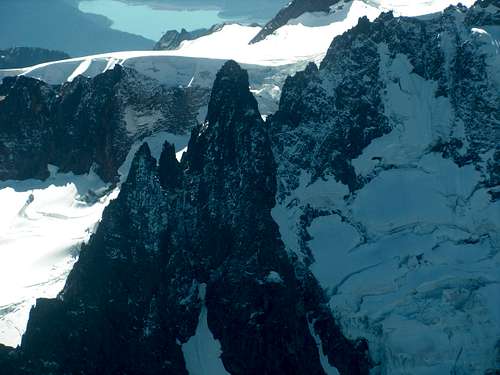
 Hozomeen Massif, with peaks listed at #1, #4, #9 (Photo Credit: "Gimpilator")
Fun Facts Of Steepness Master List (400P)
-> No person has yet completed the Top 100 Steepness Master List.-> Unlike all other major Washington peakbagging lists (such as county highpoints, county greatest prominence points, 2000' prominence peaks, isolation peaks), the Top 100 Steepness Master List does not contain any mountains located in the southwestern, southeastern, or northeastern sides of the State.
-> The average steepness of peaks on the Master List is 34.94°.
-> 24 mountains on the Top 100 Steepness Master List are on the Bulger List for Top 100 highest peaks in Washington.
-> 24 mountains on the Master List have more than 2000' of prominence.
-> The most mountains on the Master List are located in Whatcom County (24 peaks), Snohomish County (23 peaks), and Chelan County (22 peaks). The other counties with peaks making the list are Skagit (17), King (9), Kittitas (4), Okanogan (4), Jefferson (2), Pierce (1), and Mason (1).
-> Seven mountains on the Master List have summits found along county lines.
-> The highest elevation peak on the Master List is Little Tahoma Peak at 11138' (#38 for overall steepness).
-> The lowest elevation peak on the Master List is Russian Butte at 5123' (#69 for overall steepness).
-> The average elevation of peaks on the Master List is 7428'.
Updates And Revisions To Master List (400P)
October 16, 2012:-> Add unofficial name "Rouge Peak" to Peak 5380.
-> Add unofficial name "ExSpire" to Peak 5980.
-> Remove from Master List: Bonanza Peak SW (280' of clean prominence, was at Position 61), Chimney Rock North (354' of clean prominence, was at Position 81). Reason for removal: Not enough clean prominence; was originally given faulty prominence information.
-> Add to Master List: Peak 7747 ("Tradition Peak"), Peak 6799
September 20, 2015:
-> Remove from Master List: Peak 5915 (395' of clean prominence, was at Position 46). Reason for removal: Not enough clean prominence; was originally given faulty prominence information.
-> Add to Master List: West Twin Needle
-> Replace Distal Phalanx with Mantis Peak. Distal Phalanx is incorrectly listed on Tim Worth's website and "Lists of John" website as the highest point of its mountain but the higher point is actually Mantis Peak, located immediately east of Distal Phalanx. Mantis Peak has 7614' elevation with 574' of clean prominence; Distal Phalanx only has 7560'+ elevation (not 7620' as previously noted) with only 40' of clean prominence. However, this change does not affect the steepness (33.19°) or ranking (#75) of the mountain for the purposes of this list.
-> Replace Distal Phalanx with Mantis Peak on 300P and 800m lists, as well.
-> Add unofficial name "South Gemini Peak" to Peak 6799.
-> Add unofficial name "Trapper Annex" to The Trap.
October 9, 2015:
-> Remove from Master List: Seven Fingered Jack (380' of clean prominence, was at Position 78). Reason for removal: Not enough clean prominence; was originally given faulty prominence information.
-> Add to Master List: Voodoo Peak
Top 100 Steepest Peaks Of Washington (TIM WORTH'S 300P MASTER LIST)
Tim Worth created lists based upon a "peak" being defined as having at least 300' of prominence. This includes any sub-peak found on massifs, ridges, and volcanoes if such sub-peak meets the 300' of prominence standard and steepness criteria.| RANK | PEAK | SUMMIT ELEVATION | AVERAGE VERTICAL STEEPNESS (ANGLE) FROM SUMMIT | COUNTY |
| 1 | "South Hozomeen Mountain" | 8003' | 42.62° | Whatcom |
| 2 | Needle Peak | 7900' | 40.66° | Chelan |
| 3 | Mount Baring | 6125' | 40.29° | King |
| 4 | Hozomeen Mountain | 8066' | 38.86° | Whatcom |
| 5 | Mount Thomson | 6554' | 38.77° | King |
| 6 | Agnes Mountain | 8115' | 38.30° | Chelan |
| 7 | Mount Stuart | 9415' | 38.15° | Chelan |
| 8 | Sloan Peak | 7835' | 37.93° | Snohomish |
| 9 | "Southwest Hozomeen" | 7471' | 37.86° | Whatcom |
| 10 | American Border Peak | 7994' | 37.61° | Whatcom |
| 11 | "South Baring" | 6010' | 37.58° | King |
| 12 | White Chuck Mountain | 6989' | 37.27° | Snohomish |
| 13 | Mount Pugh | 7201' | 37.12° | Snohomish |
| 14 | Mount Triumph | 7260' | 37.07° | Whatcom |
| 15 | "Rouge Peak" | 5380' | 36.91° | Snohomish |
| 16 | Goode Mountain | 9220' | 36.90° | Chelan |
| 17 | Garfield Mountain West | 4896' | 36.79° | King |
| 18 | Copper Peak | 8964' | 36.78° | Chelan |
| 19 | Luna Peak | 8311' | 36.60° | Whatcom |
| 20 | Red Mountain | 5740' | 36.56° | Snohomish |
| 21 | Peak 8940 | 8940' | 36.47° | Chelan |
| 22 | Argonaut Peak | 8453' | 36.40° | Chelan |
| 23 | West McMillan Spire | 8020' | 36.40° | Whatcom |
| 24 | Trapper Mountain | 7530' | 36.32° | Chelan |
| 25 | Lincoln Peak | 9100' | 36.26° | Whatcom |
| 26 | Lemah Mountain | 7500' | 36.15° | King & Kittitas |
| 27 | Bear Mountain | 5519' | 36.13° | Snohomish |
| 28 | Mesahchie Peak | 8795' | 36.07° | Skagit |
| 29 | Chimney Rock | 7727' | 35.99° | King & Kittitas |
| 30 | Garfield Mountain | 5519' | 35.92° | King |
| 31 | Bear Mountain | 7931' | 35.84° | Whatcom |
| 32 | Colonial Peak | 7771' | 35.83° | Whatcom |
| 33 | Mount Index North | 5380' | 35.79° | Snohomish |
| 34 | Seahpo Peak | 7441' | 35.77° | Whatcom |
| 35 | Johannesburg Mountain | 8220' | 35.76° | Skagit |
| 36 | Mount Redoubt | 8969' | 35.72° | Whatcom |
| 37 | Mount Terror | 8151' | 35.72° | Whatcom |
| 38 | Forbidden Peak | 8815' | 35.53° | Skagit |
| 39 | Tower Mountain | 8444' | 35.53° | Okanogan & Skagit |
| 40 | Peak 5980 | 5980' | 35.39° | Skagit |
| 41 | Little Tahoma Peak | 11138' | 35.33° | Pierce |
| 42 | Mount Hardy | 8100' | 35.33° | Okanogan & Skagit |
| 43 | Katsuk Peak | 8700' | 35.32° | Skagit |
| 44 | Bonanza Peak | 9511' | 35.25° | Chelan |
| 45 | Lyall Ridge | 7780' | 35.23° | Chelan |
| 46 | Jack Mountain | 9066' | 35.16° | Whatcom |
| 47 | Tupshin Peak | 8340' | 35.10° | Chelan |
| 48 | Hall Peak | 5484' | 35.09° | Snohomish |
| 49 | Peak 5915 | 5915' | 35.00° | Skagit |
| 50 | Merchant Peak | 6113' | 34.91° | Snohomish |
| 51 | Mount Constance | 7756' | 34.85° | Jefferson |
| 52 | Mox Peaks HP | 8504' | 34.79° | Whatcom |
| 53 | Three Fingers South | 6850' | 34.77° | Snohomish |
| 54 | Nooksack Tower | 8285' | 34.54° | Whatcom |
| 55 | Liberty Mountain | 5700' | 34.51° | Snohomish |
| 56 | Bears Breast Mountain | 7197' | 34.38° | Kittitas |
| 57 | Peak 5884 | 5884' | 34.34° | Snohomish |
| 58 | Del Campo Peak | 6610' | 34.28° | Snohomish |
| 59 | Scott Peak | 5288' | 34.24° | Snohomish |
| 60 | Whitehorse Mountain | 6850' | 34.22° | Snohomish |
| 61 | Mount Despair | 7292' | 34.16° | Whatcom |
| 62 | Hubbart Peak | 5936' | 34.16° | Snohomish |
| 63 | Mount Phelps | 5535' | 34.09° | King |
| 64 | Mount Shuksan | 9131' | 34.07° | Whatcom |
| 65 | Bonanza Peak SW | 9320' | 34.03° | Chelan |
| 66 | Golden Horn | 8366' | 33.99° | Okanogan |
| 67 | Mount Pershing | 6154' | 33.89° | Mason |
| 68 | Martin Peak | 8511' | 33.86° | Chelan |
| 69 | Mount Forgotten | 6005' | 33.84° | Snohomish |
| 70 | Gabriel Peak | 7940' | 33.67° | Skagit |
| 71 | Grasshopper Peak | 6850' | 33.66° | Chelan |
| 72 | Hoh Peak | 5570' | 33.66° | Jefferson |
| 73 | Booker Mountain | 8300' | 33.57° | Chelan |
| 74 | Russian Butte | 5123' | 33.40° | King |
| 75 | Tomyhoi Peak | 7435' | 33.32° | Whatcom |
| 76 | Buck Mountain | 8528' | 33.30° | Chelan |
| 77 | Sheep Mountain | 6166' | 33.25° | Snohomish |
| 78 | Kimtah Peak | 8620' | 33.21° | Skagit |
| 79 | Bandit Peak | 7625' | 33.21° | Chelan |
| 80 | Dharma Gendarme | 7740' | 33.19° | Whatcom |
| 81 | Mantis Peak | 7614' | 33.19° | Skagit |
| 82 | Davis Peak | 7051' | 33.18° | Whatcom |
| 83 | Sheep Gap Mountain | 5819' | 33.17° | Snohomish |
| 84 | Cosho Peak | 8332' | 33.13° | Skagit |
| 85 | Seven Fingered Jack | 9100' | 33.12° | Chelan |
| 86 | Chimney Rock North | 7634' | 33.12° | Kittitas |
| 87 | Graybeard Peak | 7965' | 33.08° | Skagit |
| 88 | Mount Formidable | 8325' | 33.06° | Skagit |
| 89 | Black Peak | 8970' | 33.01° | Chelan & Skagit |
| 90 | Montaña Sin Nombre | 6688' | 33.01° | Whatcom |
| 91 | Clever Peak | 5808' | 33.01° | Skagit |
| 92 | Cathedral Rock | 6724' | 32.99° | Kittitas |
| 93 | Peak 5820 | 5820' | 32.96° | King |
| 94 | Mount Index Middle Peak | 5493' | 32.92° | Snohomish |
| 95 | Buckner Mountain | 9112' | 32.90° | Chelan & Skagit |
| 96 | Corteo Peak | 8100' | 32.90° | Chelan |
| 97 | The Trap | 6980' | 32.80° | Chelan |
| 98 | Morning Star Peak | 6020' | 32.79° | Snohomish |
| 99 | Azurite Peak | 8420' | 32.78° | Okanogan & Skagit |
| 100 | Heather Ridge | 7928' | 32.75° | Chelan |
 "South Hozomeen Mountain": Overall Steepest Peak In Washington
Fun Facts Of Steepness Master List (300P, Tim Worth's List)
-> Unlike all other major Washington peakbagging lists (such as county highpoints, county greatest prominence points, 2000' prominence peaks, isolation peaks), the Top 100 Steepness Master List does not contain any mountains located in the southwestern, southeastern, or northeastern sides of the State.-> The average steepness of peaks on the Master List is 35.10°.
-> 24 mountains on the Top 100 Steepness Master List are on the Bulger List for Top 100 highest peaks in Washington.
-> 24 mountains on the Master List have more than 2000' of prominence.
-> The most mountains on the Master List are located in Chelan County (23 peaks), Whatcom County (22 peaks), and Snohomish County (21 peaks). The other counties with peaks making the list are Skagit (18), King (10), Kittitas (5), Okanogan (4), Jefferson (2), Pierce (1), and Mason (1).
-> Seven mountains on the Master List have summits found along county lines.
-> The highest elevation peak on the Master List is Little Tahoma Peak at 11138' (#41 for overall steepness).
-> The lowest elevation peak on the Master List is the West Peak of Garfield Mountain (#17 for overall steepness).
 Mount Pershing: Only Peak In Mason County On Master Lists
Top 100 Steepest Peaks (100m Criteria Only)
| RANK | PEAK | SUMMIT ELEVATION | AVERAGE DROP PER ANGLE FROM SUMMIT | AVERAGE VERTICAL STEEPNESS (ANGLE) FROM SUMMIT | COUNTY |
| 1 | Nooksack Tower | 8285' | 594' | 61.08° | Whatcom |
| 2 | Mount Thomson | 6554' | 563' | 59.78° | King |
| 3 | "South Hozomeen Mountain" | 8003' | 556' | 59.45° | Whatcom |
| 4 | "Southwest Hozomeen" | 7471' | 547' | 59.07° | Whatcom |
| 5 | Tupshin Peak | 8340' | 538' | 58.64° | Chelan |
| 6 | Chimney Rock | 7727' | 533' | 58.38° | King & Kittitas |
| 7 | Peak 7940 | 7940' | 519' | 57.71° | Skagit |
| 8 | Mount Cruiser | 6104' | 498' | 56.62° | Mason |
| 9 | "Rouge Peak" | 5380' | 497' | 56.57° | Snohomish |
| 10 | Garfield Mountain | 5519' | 492' | 56.30° | King |
| 11 | Cowlitz Chimneys North | 7015' | 491' | 56.28° | Pierce |
| 12 | Lincoln Peak | 9100' | 490' | 56.20° | Whatcom |
| 13 | Forbidden Peak | 8815' | 477' | 55.48° | Skagit |
| 14 | Argonaut Peak | 8453' | 459' | 54.48° | Chelan |
| 15 | Kaleetan Peak | 6259' | 454' | 54.14° | King |
| 16 | Scott Peak | 5288' | 446' | 53.69° | Snohomish |
| 17 | Red Mountain | 5740' | 438' | 53.17° | Snohomish |
| 18 | "Hermes" | 6852' | 433' | 52.86° | Jefferson |
| 19 | Peak 6980 | 6980' | 431' | 52.75° | Skagit |
| 20 | Skadulgwas Peak | 4985' | 428' | 52.51° | Skagit |
| 21 | Garfield Mountain West | 4896' | 426' | 52.41° | King |
| 22 | Cowlitz Chimneys South | 7605' | 419' | 51.93° | Pierce |
| 23 | Peak 7060 | 7060' | 418' | 51.88° | Skagit |
| 24 | Peak 6445 | 6445' | 416' | 51.72° | Snohomish |
| 25 | Tower Mountain | 8444' | 413' | 51.56° | Okanogan & Skagit |
| 26 | Beacon Rock | 860' | 413' | 51.53° | Skamania |
| 27 | Peak 8060 | 8060' | 410' | 51.36° | Chelan |
| 28 | Mox Peaks HP | 8504' | 410' | 51.31° | Whatcom |
| 29 | Paul Bunyans Stump | 7500' | 408' | 51.20° | Whatcom |
| 30 | Mount Baring | 6125' | 407' | 51.14° | King |
| 31 | Mox Peaks West | 8407' | 407' | 51.12° | Whatcom |
| 32 | Peak 7700 | 7700' | 406' | 51.05° | Chelan & Snohomish |
| 33 | Mount Shuksan | 9131' | 406' | 51.04° | Whatcom |
| 34 | Bonanza Peak | 9511' | 405' | 51.03° | Chelan |
| 35 | Peak 5740 | 5740' | 399' | 50.59° | Jefferson |
| 36 | Sluiskin Mountain East | 7026' | 399' | 50.54° | Pierce |
| 37 | Bessemer Mountain | 5166' | 398' | 50.52° | King |
| 38 | Needle Peak | 7900' | 398' | 50.47° | Chelan |
| 39 | Bonanza Peak SW | 9320' | 397' | 50.45° | Chelan |
| 40 | Pinnacle Peak | 6562' | 397' | 50.44° | Lewis |
| 41 | "Silhouette Peak" | 7274' | 397' | 50.42° | Whatcom |
| 42 | Cathedral Rock | 6724' | 397' | 50.41° | Kittitas |
| 43 | Peak 7711 | 7711' | 395' | 50.31° | Chelan |
| 44 | Peak 5712 | 5712' | 395' | 50.30° | King |
| 45 | Peak 8940 | 8940' | 392' | 50.10° | Chelan |
| 46 | Katsuk Peak | 8700' | 392' | 50.10° | Skagit |
| 47 | "Black Tower" | 7880' | 392' | 50.07° | Chelan |
| 48 | Peak 5980 | 5980' | 391' | 50.02° | Skagit |
| 49 | "X Mountain" | 5980' | 390' | 49.91° | Whatcom |
| 50 | Peak 6980 | 6980' | 389' | 49.86° | King & Kittitas |
| 51 | Cutthroat Peak | 8050' | 389' | 49.84° | Chelan & Skagit |
| 52 | "North Garfield" | 5101' | 389' | 49.84° | King |
| 53 | Lemah Mountain | 7500' | 388' | 49.81° | King & Kittitas |
| 54 | Sheep Gap Mountain | 5819' | 388' | 49.79° | Snohomish |
| 55 | Hoh Peak | 5570' | 387' | 49.74° | Jefferson |
| 56 | "The Trap" | 6980' | 387' | 49.71° | Chelan |
| 57 | "Barbara Peak" | 6020' | 387' | 49.70° | Whatcom |
| 58 | "Bushwhack Peak" | 5145' | 387' | 49.70° | Snohomish |
| 59 | Peak 4365 | 4365' | 386' | 49.66° | King |
| 60 | Little Tahoma Peak | 11138' | 386' | 49.65° | Pierce |
| 61 | Jumpoff Ridge | 5380' | 386' | 49.63° | Snohomish |
| 62 | Overcoat Peak | 7432' | 385' | 49.57° | King |
| 63 | Gunn Peak | 6240' | 384' | 49.51° | Snohomish |
| 64 | Spire Point | 8264' | 383' | 49.45° | Chelan & Skagit |
| 65 | Trapper Mountain | 7530' | 381' | 49.25° | Chelan |
| 66 | Martin Peak | 8511' | 380' | 49.22° | Chelan |
| 67 | North Crested Butte | 5318' | 380' | 49.21° | Snohomish |
| 68 | Huckleberry Mountain | 6340' | 380' | 49.18° | King & Kittitas |
| 69 | "Cocked Hat" | 7292' | 380' | 49.16° | Whatcom |
| 70 | Mount Triumph | 7260' | 379' | 49.14° | Whatcom |
| 71 | Chimney Rock North | 7634' | 378' | 49.07° | Kittitas |
| 72 | "Middle Chief" | 7140' | 378' | 49.05° | King |
| 73 | Agnes Mountain | 8115' | 378' | 49.02° | Chelan |
| 74 | Peak 7865 | 7865' | 375' | 48.84° | Chelan & Skagit |
| 75 | Whalehead Ridge | 5300' | 374' | 48.72° | Lewis |
| 76 | "Duke of Kent" | 4860' | 373' | 48.66° | King |
| 77 | Crater Mountain East | 7555' | 372' | 48.56° | Whatcom |
| 78 | Cascade Peak | 7428' | 371' | 48.52° | Skagit |
| 79 | "Perdition Peak" | 7675' | 371' | 48.51° | Skagit |
| 80 | "Ram's Horn" | 5683' | 370' | 48.47° | Snohomish |
| 81 | Sherpa Peak | 8605' | 369' | 48.37° | Chelan |
| 82 | Twin Peaks West | 5683' | 369' | 48.34° | Snohomish |
| 83 | Del Campo Peak | 6610' | 368' | 48.27° | Snohomish |
| 84 | Mount Stone | 6612' | 367' | 48.23° | Mason |
| 85 | Mount Terror | 8151' | 367' | 48.22° | Whatcom |
| 86 | Sloan Peak | 7835' | 366' | 48.13° | Snohomish |
| 87 | White Chuck Mountain | 6989' | 366' | 48.12° | Snohomish |
| 88 | "Salish Peak" | 5700' | 365' | 48.08° | Snohomish |
| 89 | Russian Butte | 5123' | 365' | 48.06° | King |
| 90 | "The Saint" | 7185' | 365' | 48.02° | Whatcom |
| 91 | Monte Cristo Peak | 7136' | 364' | 48.00° | Snohomish |
| 92 | Bald Eagle Peak | 6241' | 364' | 47.99° | King |
| 93 | "Salmon Red" | 5139' | 364' | 47.94° | King |
| 94 | Mount Hardy | 8100' | 363' | 47.87° | Okanogan & Skagit |
| 95 | "Long Gone Peak" | 7020' | 362' | 47.86° | Skagit |
| 96 | Mount Constance | 7756' | 361' | 47.77° | Jefferson |
| 97 | "The Bat" | 6475' | 361' | 47.75° | Skagit |
| 98 | Mount Pershing | 6154' | 360' | 47.62° | Okanogan |
| 99 | Golden Horn | 8366' | 359' | 47.62° | Mason |
| 100 | Peak 4780 | 4780' | 358' | 47.48° | Jefferson |
 Nooksack Tower: Steepest Peak Of 100m Criteria
Top 100 Steepest Peaks (800m Criteria Only)
| RANK | PEAK | SUMMIT ELEVATION | AVERAGE DROP PER ANGLE FROM SUMMIT | AVERAGE VERTICAL STEEPNESS (ANGLE) FROM SUMMIT | COUNTY |
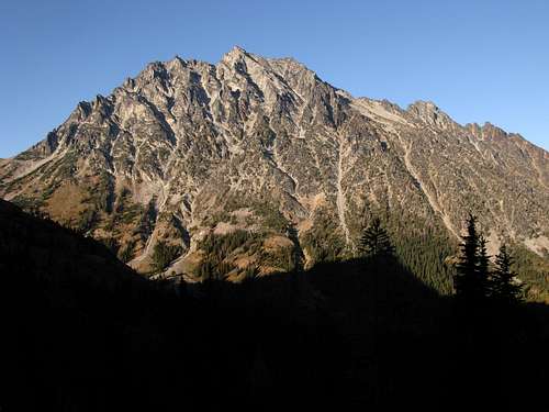
| 1 | Mount Baring | 6125' | 2286.73' | 41.07° | King |
| 2 | Needle Peak | 7900' | 2255.97' | 40.69° | Chelan |
| 3 | "South Hozomeen Mountain" | 8003' | 2243.02' | 40.52° | Whatcom |
| 4 | Hozomeen Mountain | 8066' | 2212.14' | 40.13° | Whatcom |
| 5 | Agnes Mountain | 8115' | 2127.28' | 39.03° | Chelan |
| 6 | American Border Peak | 7994' | 2045.77' | 37.94° | Whatcom |
| 7 | Mount Stuart | 9415' | 2041.25' | 37.88° | Chelan |
| 8 | Mount Index North | 5380' | 2030.88' | 37.74° | Snohomish |
| 9 | Mount Pugh | 7201' | 2018.86' | 37.57° | Snohomish |
| 10 | Goode Mountain | 9220' | 2001.19' | 37.33° | Chelan |
| 11 | "South Baring" | 6010' | 2000.21' | 37.32° | King |
| 12 | Mount Triumph | 7260' | 1984.05' | 37.09° | Whatcom |
| 13 | Luna Peak | 8311' | 1982.71' | 37.07° | Whatcom |
| 14 | Sloan Peak | 7835' | 1964.92' | 36.83° | Snohomish |
| 15 | Trapper Mountain | 7530' | 1959.40' | 36.75° | Chelan |
| 16 | Bear Mountain | 5519' | 1957.06' | 36.72° | Snohomish |
| 17 | Lemah Mountain | 7500' | 1953.86' | 36.67° | King & Kittitas |
| 18 | West McMillan Spire | 8020' | 1951.29' | 36.64° | Whatcom |
| 19 | White Chuck Mountain | 6989' | 1935.38' | 36.41° | Snohomish |
| 20 | Merchant Peak | 6113' | 1912.22' | 36.08° | Snohomish |
| 21 | Copper Peak | 8964' | 1892.90' | 35.81° | Chelan |
| 22 | Gabriel Peak | 7940' | 1887.42' | 35.73° | Skagit |
| 23 | Mount Thomson | 6554' | 1863.60' | 35.38° | King |
| 24 | Mount Bullon | 5980' | 1856.49' | 35.28° | Snohomish |
| 25 | Little Tahoma Peak | 11138' | 1853.25' | 35.23° | Pierce |
| 26 | Johannesburg Mountain | 8220' | 1852.24' | 35.22° | Skagit |
| 27 | Bear Mountain | 7931' | 1835.86' | 34.98° | Whatcom |
| 28 | Elephant Butte | 7380' | 1833.81' | 34.95° | Whatcom |
| 29 | Colonial Peak | 7771' | 1831.18' | 34.91° | Whatcom |
| 30 | Clever Peak | 5808' | 1827.92' | 34.86° | Skagit |
| 31 | Mount Constance | 7756' | 1824.48' | 34.81° | Jefferson |
| 32 | Hall Peak | 5484' | 1823.32' | 34.79° | Snohomish |
| 33 | Mount Terror | 8151' | 1822.59' | 34.78° | Whatcom |
| 34 | Mesahchie Peak | 8795' | 1815.50' | 34.68° | Skagit |
| 35 | Argonaut Peak | 8453' | 1809.68' | 34.59° | Chelan |
| 36 | Little J-Berg | 7945' | 1809.63' | 34.59° | Skagit |
| 37 | Burnt Boot Peak | 6540' | 1807.37' | 34.56° | King |
| 38 | Seahpo Peak | 7441' | 1805.65' | 34.53° | Whatcom |
| 39 | Mount Forgotten | 6005' | 1797.96' | 34.42° | Snohomish |
| 40 | Graybeard Peak | 7965' | 1797.24' | 34.41° | Skagit |
| 41 | Mount Redoubt | 8969' | 1796.99' | 34.40° | Whatcom |
| 42 | Whitehorse Mountain | 6850' | 1794.63' | 34.37° | Snohomish |
| 43 | Voodoo Peak | 5198' | 1793.33' | 34.35° | Snohomish |
| 44 | Garfield Mountain West | 4896' | 1792.11' | 34.33° | King |
| 45 | Peak 5980 | 5980' | 1786.48' | 34.25° | Skagit |
| 46 | Sperry Peak | 6140' | 1773.86' | 34.06° | Snohomish |
| 47 | Peak 5915 | 5915' | 1771.95' | 34.03° | Skagit |
| 48 | "Rouge Peak" | 5380' | 1770.12' | 34.00° | Snohomish |
| 49 | Bears Breast Mountain | 7197' | 1763.36' | 33.90° | Kittitas |
| 50 | Peak 5884 | 5884' | 1759.76' | 33.85° | Snohomish |
| 51 | Mount Hardy | 8100' | 1758.26' | 33.82° | Okanogan & Skagit |
| 52 | Peak 8940 | 8940' | 1757.19' | 33.81° | Chelan |
| 53 | Lyall Ridge | 7780' | 1756.67' | 33.80° | Chelan |
| 54 | Hubbart Peak | 5936' | 1744.95' | 33.62° | Snohomish |
| 55 | Seven Fingered Jack | 9100' | 1734.59' | 33.47° | Chelan |
| 56 | Lincoln Peak | 9100' | 1731.72' | 33.42° | Whatcom |
| 57 | Tower Mountain | 8444' | 1724.44' | 33.31° | Okanogan & Skagit |
| 58 | Peak 7102 | 7102' | 1717.25' | 33.20° | Skagit |
| 59 | Big Four Mountain | 6180' | 1716.45' | 33.19° | Snohomish |
| 60 | Booker Mountain | 8300' | 1715.35' | 33.17° | Chelan |
| 61 | Mount Formidable | 8325' | 1711.45' | 33.11° | Skagit |
| 62 | Castle Peak | 8306' | 1711.24' | 33.11° | Okanogan & Whatcom |
| 63 | Lewis Peak | 5608' | 1709.79' | 33.09° | Snohomish |
| 64 | Three Fingers South | 6850' | 1709.58' | 33.08° | Snohomish |
| 65 | Liberty Mountain | 5700' | 1708.88' | 33.07° | Snohomish |
| 66 | Red Mountain | 5740' | 1699.63' | 32.93° | Snohomish |
| 67 | Grasshopper Peak | 6850' | 1696.86' | 32.89° | Chelan |
| 68 | Mount Phelps | 5535' | 1694.84' | 32.86° | King |
| 69 | "Southwest Hozomeen" | 7471' | 1686.50' | 32.73° | Whatcom |
| 70 | Mount Ballard | 8340' | 1684.58' | 32.70° | Whatcom |
| 71 | Mount Index - Middle Peak | 5493' | 1683.99' | 32.69° | Snohomish |
| 72 | Oakes Peak | 5681' | 1680.29' | 32.63° | Whatcom |
| 73 | Mount Washington | 6255' | 1677.55' | 32.59° | Mason |
| 74 | Little Greider Peak | 4602' | 1677.37' | 32.59° | Snohomish |
| 75 | Corteo Peak | 8100' | 1675.03' | 32.55° | Chelan |
| 76 | Tradition Peak | 7747' | 1674.82' | 32.55° | Whatcom |
| 77 | Azurite Peak | 8420' | 1669.24' | 32.46° | Okanogan & Skagit |
| 78 | Jack Mountain | 9066' | 1668.93' | 32.46° | Whatcom |
| 79 | Mount Maude | 9060' | 1667.02' | 32.43° | Chelan |
| 80 | Golden Horn | 8366' | 1663.90' | 32.38° | Okanogan |
| 81 | Mount Crowder | 7082' | 1662.34' | 32.35° | Whatcom |
| 82 | Kimtah Peak | 8620' | 1661.33' | 32.34° | Skagit |
| 83 | Inner Constance | 7667' | 1660.64' | 32.33° | Jefferson |
| 84 | Morning Star Peak | 6020' | 1659.68' | 32.31° | Snohomish |
| 85 | West Twin Needle | 7936' | 1659.06' | 32.30° | Whatcom |
| 86 | Mount Index | 5991' | 1658.37' | 32.29° | King |
| 87 | Mox Peaks HP | 8504' | 1646.11' | 32.10° | Whatcom |
| 88 | Mantis Peak | 7614' | 1645.60' | 32.09° | Skagit |
| 89 | Jordan Benchmark | 6397' | 1645.18' | 32.09° | Skagit |
| 90 | Peak 7265 | 7265' | 1640.62' | 32.02° | Chelan |
| 91 | Buckner Mountain | 9112' | 1638.88' | 31.99° | Chelan & Skagit |
| 92 | Little Jackass Mountain | 4387' | 1638.35' | 31.98° | Whatcom |
| 93 | Whistler Mountain | 7790' | 1637.93' | 31.97° | Chelan |
| 94 | Mount Despair | 7292' | 1635.99' | 31.94° | Whatcom |
| 95 | Mount Larrabee | 7861' | 1634.86' | 31.92° | Whatcom |
| 96 | Dharma Gendarme | 7740' | 1634.43' | 31.92° | Whatcom |
| 97 | Whatcom Peak | 7574' | 1629.77' | 31.84° | Whatcom |
| 98 | Montaña Sin Nombre | 6688' | 1628.30' | 31.82° | Whatcom |
| 99 | Katsuk Peak | 8700' | 1626.05' | 31.79° | Skagit |
| 100 | Heather Ridge | 7928' | 1623.45' | 31.74° | Chelan |
 Mount Baring: Steepest Peak Of 800m Criteria
Top 100 Steepest Peaks (1600m Criteria Only)
| RANK | PEAK | SUMMIT ELEVATION | AVERAGE DROP PER ANGLE FROM SUMMIT | AVERAGE VERTICAL STEEPNESS (ANGLE) FROM SUMMIT | COUNTY |
| 1 | Mount Stuart | 9415' | 3191.29' | 31.30° | Chelan |
| 2 | Johannesburg Mountain | 8220' | 3155.39' | 31.02° | Skagit |
| 3 | Luna Peak | 8311' | 3132.28' | 30.83° | Whatcom |
| 4 | Needle Peak | 7900' | 3129.67' | 30.81° | Chelan |
| 5 | Mount Pugh | 7201' | 3100.12' | 30.57° | Snohomish |
| 6 | American Border Peak | 7994' | 3073.40' | 30.35° | Whatcom |
| 7 | Tomyhoi Peak | 7435' | 3059.35' | 30.24° | Whatcom |
| 8 | "South Hozomeen Mountain" | 8003' | 3026.18' | 29.97° | Whatcom |
| 9 | Sloan Peak | 7835' | 3024.50' | 29.96° | Snohomish |
| 10 | Goode Mountain | 9220' | 2971.99' | 29.52° | Chelan |
| 11 | Jack Mountain | 9066' | 2927.69' | 29.16° | Whatcom |
| 12 | "South Baring" | 6010' | 2916.38' | 29.06° | King |
| 13 | Grasshopper Peak | 6850' | 2910.99' | 29.02° | Chelan |
| 14 | Hozomeen Mountain | 8066' | 2909.48' | 29.00° | Whatcom |
| 15 | Big Four Mountain | 6180' | 2864.89' | 28.63° | Snohomish |
| 16 | Elephant Butte | 7380' | 2840.52' | 28.42° | Whatcom |
| 17 | Tradition Peak | 7747' | 2834.70' | 28.38° | Whatcom |
| 18 | North Big Bosom Butte | 6384' | 2818.29' | 28.24° | Whatcom |
| 19 | Peak 8940 | 8940' | 2807.91' | 28.15° | Chelan |
| 20 | White Chuck Mountain | 6989' | 2806.77' | 28.14° | Snohomish |
| 21 | Glory Mountain | 7228' | 2805.24' | 28.13° | Chelan |
| 22 | Copper Peak | 8964' | 2799.68' | 28.08° | Chelan |
| 23 | Davis Peak | 7051' | 2798.88' | 28.07° | Whatcom |
| 24 | Mount Shuksan | 9131' | 2798.61' | 28.07° | Whatcom |
| 25 | Colonial Peak | 7771' | 2793.60' | 28.03° | Whatcom |
| 26 | Mesahchie Peak | 8795' | 2792.31' | 28.02° | Skagit |
| 27 | Mount Baring | 6125' | 2775.29' | 27.87° | King |
| 28 | Jumbo Mountain | 5860' | 2756.24' | 27.71° | Snohomish |
| 29 | Hubbart Peak | 5936' | 2755.17' | 27.70° | Snohomish |
| 30 | Katsuk Peak | 8700' | 2746.30' | 27.62° | Skagit |
| 31 | Elija Ridge West | 7665' | 2744.38' | 27.61° | Whatcom |
| 32 | Mount Ballard | 8340' | 2734.87' | 27.53° | Whatcom |
| 33 | Heather Ridge | 7928' | 2734.84' | 27.52° | Chelan |
| 34 | Lyall Ridge | 7780' | 2734.63' | 27.52° | Chelan |
| 35 | Chimney Peak | 6917' | 2712.87' | 27.34° | Jefferson |
| 36 | Black Peak | 8970' | 2712.85' | 27.34° | Chelan & Skagit |
| 37 | Blister Mountain | 5447' | 2708.86' | 27.30° | Whatcom |
| 38 | Sheep Mountain | 6166' | 2696.56' | 27.20° | Snohomish |
| 39 | Whitehorse Mountain | 6850' | 2696.53' | 27.20° | Snohomish |
| 40 | Red Mountain | 5740' | 2695.51' | 27.19° | Snohomish |
| 41 | Bandit Peak | 7625' | 2691.63' | 27.15° | Chelan |
| 42 | Three Fingers South | 6850' | 2689.93' | 27.14° | Snohomish |
| 43 | Buckner Mountain | 9112' | 2686.67' | 27.11° | Chelan & Skagit |
| 44 | "Revelations" | 6872' | 2681.73' | 27.07° | Whatcom |
| 45 | Peak 5820 | 5820' | 2675.01' | 27.01° | King |
| 46 | Bear Mountain | 7931' | 2672.88' | 26.99° | Whatcom |
| 47 | East Fury | 8300' | 2667.10' | 26.94° | Whatcom |
| 48 | "Southwest Hozomeen" | 7471' | 2661.62' | 26.89° | Whatcom |
| 49 | Mount Despair | 7292' | 2653.35' | 26.82° | Whatcom |
| 50 | Bonanza Peak | 9511' | 2648.11' | 26.78° | Chelan |
| 51 | Burgler Bear | 6170' | 2642.17' | 26.72° | Whatcom |
| 52 | Mount Redoubt | 8969' | 2632.38' | 26.64° | Whatcom |
| 53 | "Sunny Girl" | 6180' | 2628.62' | 26.61° | Skagit |
| 54 | Nodoubt Peak | 7290' | 2627.91' | 26.60° | Whatcom |
| 55 | Seahpo Peak | 7441' | 2623.74' | 26.56° | Whatcom |
| 56 | Mount Index | 5991' | 2616.40' | 26.50° | King |
| 57 | Buck Mountain | 8528' | 2611.69' | 26.46° | Chelan |
| 58 | "Styloid" | 6972' | 2610.19' | 26.44° | Skagit |
| 59 | Nlaka-pamux Peak | 6607' | 2603.06' | 26.38° | Whatcom |
| 60 | Del Campo Peak | 6610' | 2587.35' | 26.24° | Snohomish |
| 61 | Mount Saul | 7300' | 2584.19' | 26.22° | Chelan |
| 62 | Mount Baker | 10781' | 2580.35' | 26.18° | Whatcom |
| 63 | Gabriel Peak | 7940' | 2576.03' | 26.14° | Skagit |
| 64 | Agnes Mountain | 8115' | 2573.43' | 26.12° | Chelan |
| 65 | Bedal Peak | 6554' | 2572.33' | 26.11° | Snohomish |
| 66 | Garfield Mountain West | 4896' | 2568.39' | 26.08° | King |
| 67 | Lunatic Peak | 6115' | 2567.33' | 26.07° | Whatcom |
| 68 | Booker Mountain | 8300' | 2566.10' | 26.06° | Chelan |
| 69 | Rojo Peak | 5158' | 2556.18' | 25.97° | Snohomish |
| 70 | Nameless Mountain | 6616' | 2545.94' | 25.88° | Whatcom |
| 71 | The Pleiades East | 7340' | 2543.01' | 25.85° | Whatcom |
| 72 | Mount Sefrit | 7191' | 2539.19' | 25.82° | Whatcom |
| 73 | Mount Hardy | 8100' | 2537.11' | 25.80° | Okanogan & Skagit |
| 74 | Mount Larrabee | 7861' | 2529.66' | 25.74° | Whatcom |
| 75 | Heretic Hill | 5612' | 2526.74' | 25.71° | Whatcom |
| 76 | Mount Pershing | 6154' | 2526.01' | 25.70° | Mason |
| 77 | West McMillan Spire | 8020' | 2520.10' | 25.65° | Whatcom |
| 78 | Kimtah Peak | 8620' | 2519.69' | 25.65° | Skagit |
| 79 | The Brothers | 6842' | 2510.34' | 25.56° | Jefferson |
| 80 | Liberty Cap | 14112' | 2509.24' | 25.55° | Pierce |
| 81 | Mount Tom | 7076' | 2504.75' | 25.51° | Jefferson |
| 82 | Peak 7140 | 7140' | 2500.94' | 25.48° | Chelan |
| 83 | Elija Ridge | 7739' | 2493.31' | 25.41° | Whatcom |
| 84 | Mount Persis | 5464' | 2487.38' | 25.36° | Snohomish |
| 85 | Apple Peak | 6763' | 2483.20' | 25.32° | Whatcom |
| 86 | Liberty Mountain | 5700' | 2481.03' | 25.30° | Snohomish |
| 87 | Mount Fury | 8300' | 2478.81' | 25.28° | Whatcom |
| 88 | Spring Mountain | 5770' | 2469.02' | 25.20° | Snohomish |
| 89 | Garfield Mountain | 5519' | 2466.98' | 25.18° | King |
| 90 | Crater Mountain | 8128' | 2463.06' | 25.14° | Whatcom |
| 91 | Mount Phelps | 5535' | 2461.37' | 25.13° | King |
| 92 | Mount Fernow | 9249' | 2460.07' | 25.12° | Chelan |
| 93 | Whatcom Peak | 7574' | 2459.75' | 25.11° | Whatcom |
| 94 | Mount Terror | 8151' | 2455.29' | 25.07° | Whatcom |
| 95 | Peak 7730 | 7730' | 2452.90' | 25.05° | Chelan |
| 96 | Mount Crowder | 7082' | 2452.62' | 25.05° | Whatcom |
| 97 | Mount Degenhardt | 8020' | 2451.51' | 25.04° | Whatcom |
| 98 | Majestic I - North Peak | 7510' | 2443.02' | 24.96° | Whatcom |
| 99 | West Twin Needle | 7936' | 2441.74' | 24.95° | Whatcom |
| 100 | Scott Peak | 5288' | 2441.12' | 24.95° | Snohomish |
 Mount Stuart: Steepest Peak Of 1600m Criteria
External Links
Tim Worth's National Elevation Dataset (NED) related website provides a valuable resource for determining and recognizing peak steepness, as well as in-depth explanations of analysis and useful pictorials.The USGS National Elevation Dataset website provides a valuable resource for the foundation of this peakbagging category.
Redwic - Jan 31, 2011 11:39 pm - Hasn't voted
Two Master Lists CreatedThinking thoroughly about this List page, I decided to create *two* Master Lists. One Master List shows peaks that are defined as having a minimum 300' of prominence, which is the standard Tim Worth originally used. Another Master List only shows peaks that are defined as having a minimum 400' of prominence. A 400P type of peak list tends to be most agreeable amongst peakbaggers, especially those in/around Washington. I will leave it to the individuals to decide which Master List to use; there are only six different peaks on each list. I will keep Tim Worth's original 100m, 800m, and 1600m steepness lists on the page, as a general reference. He put quite a lot of effort into those lists, and that effort should not be forgotten.
Redwic - Jan 31, 2011 11:41 pm - Hasn't voted
GPS CoordinatesSometime soon, I plan to include either an online map link, GPS coordinates, or both for each peak shown on the Master List(s).