-
 19921 Hits
-
 85.87% Score
-
 21 Votes
|
|
Mountain/Rock |
|---|---|
|
|
45.80570°N / 6.88740°E |
|
|
10666 ft / 3251 m |
|
|
Overview
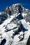
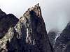
One of the lowest satellite peaks clustered around the south (Italian) face of Mont Blanc. This singularly regular rock pyramid, well visible from the Val Veny valley floor (especially around Plan Lognan), deserves to be known more widely. It’s not only a great panoramic point over the lower Freney basin (just in front of colossal west face of the Aiguille Noire Du Peuterey, and with a privileged view over Picco Gugliermina, the Aiguille Blanche and the Freney pillars), but on its 350 East and South-East side there have been traced several spectacular and very exposed rock climbs of different type (traditional and modern), whose use is greatly enhanced by the presence of a comfortable base as the Franco Monzino hut. The name remembers Joseph Croux, a famous Courmayeur guide of the late XIX° century. The Croux family gave to Courmayeur several important guides, including Evariste and Eliseè (who linked his name to several difficult routes on the Grandes Jorasses, and made, together with Armand Charlet, the first serious attempt to climb the Walker spur)
 |  |  |  |  |
Getting There
From Courmayeur (Italy)- By car through the Val Veny mountain road until the car park at La Visaille / Plan Lognan or (500 m. below) at Plan Veny (near the picnic area). Private access to this road is regulated from 1 to 20 August .
- By the bus service – one trip each 40 minutes. In Courmayeur the bus can be taken from the Bus Station (near the tunnel highway entrance).
 |  |  |
Red Tape
In the area mineral and flower collection is forbidden. The same goes for making fires, and free camping under 2500 m. Hunting and fishing goes under local seasonal rules (ask in Courmayeur).When To Climb
This is definitely a summer objective, not only because in winter most of the Val Veny northern slopes are avalanche prone. However, most of these routes have been done in winter, and in particularly good conditions the SE face tends to dry quickly even in winter. Thus said, stick to the summer. Except for the normal route and the Innominata col slope, none of the routes of the Aig. Croux are particularly dangerous with hot weather
Routes Overview
Several topos of these and other routes in the area are available inside the Monzino hut. Check beforehand at the Bureau Des Guides in Courmayeur: (tel. +39 0165 842064; fax. +39 0165 842357; email info@guidecourmayeur.com).Chatelet basin
The Glacier du Chatelet is a miniscule and almost extinct glacier (still with some crevasse, pay attention while crossing!) that lies between the Punta Innominata and the Aiguille Croux. The glacier is dominated by the W and SW face of the Aiguille Croux, and by the S face of Punta Innominata. In between, the Col De L’Innominata, now the only practical access to the lower Freney basin (and one of the sites of the 1961 tragedy at the Central Pillar of Freney)
- SW face and S ridge (normal route)(Mazzucchi with J.&H. Croux, 1900, AD-, IV, 250m) Absolutely delightful moderate rock climb, one of the best in the entire massif for this grade (highly recommended).
- Sw ridge (“Fil Rouge”)(Datrino/Signo, 1990, D+, V, 250m.) A good bolt equipped route, on a very varied terrain, (recommended).
- NW ridge (Magni/Santi/Tedeschi, 1907, D, IV-V.) This is the Col De L’Innominata – Aiguille Croux ridge. It’s quite broken and complex.
This is the most remote side of the Aiguille Croux. Can be reached from the Monzino hut crossing the Col De L’Innominata (2.30h from the hut), then rappelling down the other side (allow 3 hours from the hut)
- ENE spur (Ottoz-Nava route) (Ottoz/Nava,1955,TD, V/VI+, A2, 200m.) A classic in a wonderful environment, now rarely repeated. There’s an equipped rappel descent on the left side, used for rescue drill by the Courmayeur guides.
- (“Vuoto a Perdere”) (Azzalea,Motto,Predan, ED2, 7b, 350m) It was a very, very tough free climb on beautiful rock, comparable (but shorter) to some Tacul area climb. Unfortunately, recent movement of the rock have all but destroyed the first two pitches. Too bad...
This is Aiguille Croux’s sunny side, and the most frequented too. It’s easily reachable from the Monzino hut following a trail that goes to the right in the Freney glacier direction. You cross a small grassy hill, and then you descend on the other side toward a scree slope that border the vertical SE face. This used to be the approach to the “Brogliatta”, a low-angled rock slab that allowed a fast access to the Freney glacier (and the climbs on the other side – i.e.W face of the Aig. Noire). However, the passage here is now closed – I’ve heard recent reports of parties spending as long as 7 hours negotiating the crevasses and ice towers in the crossing. This is NOT a seasonal problem!
- Bertone route (Bertone/Zappelli,1967,ED, A3, VI, 350 m). When first opened it was basically a big wall route (the FA party spent 3 days on the face). Very sustained, still mainly aid-climbed
- “Demi Portion”(Anker/Piola,1989,6c/7a or A0, 100 m) While the openers went as far as the summit, their opinion was that only the first 4 pitches were worth bothering.
- SE face (Ottoz-Hurzeler route) (Hurzeler w/ Ottoz, 1935, D+, V°, 350 m.) The most frequented route of the peak – a very nice (and really exposed!) climb with bolt stances and rap descent equipped by the Courmayeur guides. Decent rock everywhere. (recommended)
- “Euroteam”(Long/Motto/Vogler,1992,6c or 6b/A0, 320 m.) Very sustained, repeated several times even in winter.
- “Que cherches tu Jean Marie?”(Motto, Vogler, 6c or 6B/A0, 320 m) Another sustained and athletic free climb, very well equipped. This said, Matteo Giglio, a Courmayeur guide and a specialist of the area wrote a "review" of the route not exactly positive - you can read it LINK here(recommended)
 |
Descent
There’s a number of equipped descent on the SW and SE face (the best one being the one going down the Ottoz-Hurzeler) , whose state must be checked locally (ask to the Monzino hut warden!) before committing yourself. However, going down the normal route is the most practical option: from the large ledge below 2 x 20 m. rap from the ledge below the SE summit. Right down a 35 m. ramp, then 6 x 25m. rap (from the end of the 2nd you have to climb down a bit to the left to reach the start of the 3rd), then down the snow slope (and another 25 m. rap) you reach the Chatelet glacier. From there, follow the tracks until the Monzino Hut
Camping
Free camping in the Aosta Valley region is not allowed below 2500 m. However, it's tolerated if you don't create hassles or particular troubles. This includes, of course, making fires in the woods!Here's a list of camping in Val Veny, all accessible by car or by bus from Courmayeur. In strict alphabetical order:
Camping Aiguille Noire ("www.aiguillenoire.com, ) - in Val Veny, at Zerotta, near lower station of the chair lift. (tel. +39 0165 869041 Fax +39 0165 843097). A good place for families and big groups. Used to be also the cheapest, but price right now are almost the same everywhere.
Camping Cuignon – in Val Veny between Zerotta and the military barracks (tel +39 0165 869073 Fax +39 0165 842861). This one is a bit of a question mark for me, because I don’t know anyone who’s been there. For outside it looks quite neat and smaller than Aiguille Noire
Camping La Sorgente (www.campinglasorgente.net, ) – in Val Veny, in a clearing of the forest called Peuterey, exactly under the Mont Noir south face (tel. +39 0165 848209 or, in summer +39 0165 869089). The location of this one is gorgeous (the ancient forest nearby is said to have been a Celtic worship centre). They’re really climber-friendly, and the camping itself is well organised.
On the Val Ferret:
Camping Grandes Jorasses ( www.grandesjorasses.com) in Val Ferret between Planpincieux and the golf course. (tel +39 0165 869708). Being near Planpincieux, it’s a lively and well placed on a partially wooden area.
Camping Tronchey – in Val Ferret just in front of the entrance of the golf club, right under the monstrous Tronchey Face of the Grandes Jorasses. (tel. +39 0165 869707). Nearby there’s Bar Tronchey (or “Chez Giulietta”), where at noon you can eat an incredible rabbit with polenta.
If you’re willing to spend a little more, a nice alternative to camping can be the ( Chalet Val Ferret). It’s a seven room little hotel + restaurant at Arnouva, where the Val Ferret road ends – just in front of the opening of the Triolet basin. The place is beyond gorgeous, and you’re in a good position both for climbing and hiking. A guide who’s a friend of mine used it for his climbing stage for kids and was really enthusiastic. Also, you can ask the manager for any kind of indication on the nearest sport and trad climbs of the trendy Triolet area.
On the other hand, if you don’t like camping and you’re tight with money, you can consider sleeping in one of the low altitudes “refuges”. There are the ( Elisabetta hut ), at the head of Val Veny near the Col De La Seigne, the ( Elena hut ) and the (UGET Monte Bianco hut) In all these places accommodation varies - the Elisabetta is quite spartan, the Elena almost a luxurious, the Monte Bianco somewhere halfway. If you want to consider staying there for several days, you’ve to book well in advance (In August and July these places becomes quite packed with hikers doing the Tour De Mont Blanc.)
Mountain Conditions
For all informations on the mountain conditions you MUST contact the Bureau Des Guides of Courmayeur (tel. +39 0165 842064; fax. +39 0165 842357; email info@guidecourmayeur.com). They’ve an excellent local weather service, and are always well informed on the conditions up there.A new official source of informations on mountain condition for the Italian side of the MB massif is the Fondazione Montagna Sicura , the Safe Mountain Foundation, a guide sponsored organism that work in collaboration with the French OHM to create a network of information exchange for alpinist. It's very important you check their multilingual website or contact them at
Loc. Villard De La Palud 1 11013 Courmayeur (AO)
Ph: 0039 0165 897602 Fax: 0039 0165 897647
E-Mail: villacameron@fondms.org
The quickest source of informations on the weather on the southern side of the massif is the webcam at
Remember that this cam "sees" only the central portion of the main ridge - Aiguille Crouxis located one mile to the left.
This very informative site has also plenty of informations on accomodation, place where to eat, etc. in the area.