-
 26024 Hits
-
 86.37% Score
-
 22 Votes
|
|
Mountain/Rock |
|---|---|
|
|
45.77880°N / 6.80170°E |
|
|
12522 ft / 3817 m |
|
|
Overview
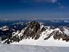
One of the most overlooked among the peaks of the Mt. Blanc massif, this peak show an elegant piramidal form on the southern (Italian) side, where it dominates the beautiful Combal plan, at the top of the Val Veny. It's a little more undistinguished on the French side, where it's accessible from the Valleè Des Glaciers or from the French Trelatete glacier. While the quality of the rock isn't up to the level of the rest of the massif, some of the routes are interesting. The view from the top is stunning, one of the best of the entire area.
 |  |  |  |  |
Red Tape
It used to be possible to drive up to the Combal plan, and with a four wheel drive vehicle even up to the Elisabetta Hut. However, massive rockfall from the Mont Fortin (on the southern side of the Combal basin) and increasing pollution problems made local authorities decide to put a barrier at La Visaille / Plan Lognan. And so, you have to walk all the 5 kms from the car parking to the Elisabetta, as it used to be until 1970. In the area mineral and flower collection is forbidden. The same goes for making fires, and free camping under 2500 m. Hunting and fishing goes under local seasonal rules (ask in Courmayeur).
 |  |  |  |
Getting There
From Courmayeur (Italy)- By car through the Val Veny mountain road until the car park at La Visaille / Plan Lognan or (500 m. below) at Plan Veny (near the picnic area). Private access to this road is regulated from 1 to 20 August .
- By the bus service – one trip each 40 minutes. In Courmayeur the bus can be taken from the Bus Station (near the tunnel highway entrance).
From Bourg St. Maurice (France)
· By car, taking the direction to Bonneval-Les Chapieux-Beaufort, you reach after 20 km Les Chapieux car park, shops, one little hotel). From here, a non metalled road (closed in winter!) traverse the lonely (and sparlesly populated) Valle Des Glaciers, and reaches in 7 km Les Mottets (very good hotel-refuge).
Routes Overview
This sector of the massif isn't made of the trademark MB granite, but of much looser material. And so, the best routes are on snow, or mixed. Thus said, Aiguille Des Glaciers is a worthwhile alpine target.- From S on the Glacier de Glaciers (normal route) – PD, 1600 m., mostly on snow (recommended)
- SW ridge (French normal route) – PD, 1300 m., mostly on snow (recommended)
- W spur – AD, 1150 m., mixed
- WNW face – D+, 1100m, moderate ice climbing (50°), relatively dangerous
- N ridge – AD, 1600m., mostly on snow (recommended)
- E spur, right side – D, IV, 500 m., fair rock
- E face, central spur – prob. D, IV/V, 500, unrepeated
- E face, goulotte Sylvie – TD, IV/V, 70°, difficult ice climb with mixed passages
- SE ridge, east flank – prob. AD, 600 m, mostly on rock, unrepeated
- SE ridge – AD+, IV, 1700 m (height gain 600m) - classic but lenghty mixed route with some interesting rock passage (recommended)
- SSE face – AD, 600 m., rock scramble, good rock but some stonefall danger
- S ridge – PD, II/III, glacier walk and some climbing, faster route from Italy, some stonefall danger
When To Climb
While it's now normal to climb in the massif all year round (thanks to improved access and midler winters), and while the normal route to this mountain is normally done with skis, this area is subject to a big avalanche risk, and so the "normal" season is from late springtime to early autumn Beware that, in recent years, in July and August higher temperatures have created some problem with "grey" glaciers and increased rockfall risk.
Camping
Free camping in the Aosta Valley region is not allowed below 2500 m. However, it's tolerated if you don't create hassles or particular troubles. This includes, of course, making fires in the woods!Here's a list of camping in Val Veny, all accessible by car or by bus from Courmayeur. In strict alphabetical order:
- Camping Aiguille Noire (www.aiguillenoire.com, ) - in Val Veny, at Zerotta, near lower station of the chair lift. (tel. +39 0165 869041 Fax +39 0165 843097). A good place for families and big groups. Used to be also the cheapest, but price right now are almost the same everywhere.
- Camping Cuignon – in Val Veny between Zerotta and the military barracks (tel +39 0165 869073 Fax +39 0165 842861). This one is a bit of a question mark for me, because I don’t know anyone who’s been there. For outside it looks quite neat and smaller than Aiguille Noire
- Camping La Sorgente (www.campinglasorgente.net, ) – in Val Veny, in a clearing of the forest called Peuterey, exactly under the Mont Noir south face (tel. +39 0165 848209 or, in summer +39 0165 869089). The location of this one is gorgeous (the ancient forest nearby is said to have been a Celtic worship centre). They’re really climber-friendly, and the camping itself is well organised.
- Camping Grandes Jorasses ( www.grandesjorasses.com) in Val Ferret between Planpincieux and the golf course. (tel +39 0165 869708). Being near Planpincieux, it’s a lively and well placed on a partially wooden area.
- Camping Tronchey – in Val Ferret just in front of the entrance of the golf club, right under the monstrous Tronchey Wall of the Grandes Jorasses. (tel. +39 0165 869707). Nearby there’s Bar Tronchey (or “Chez Giulietta”), where at noon you can eat an incredible rabbit with polenta.
- If you’re willing to spend a little more, a nice alternative to camping can be the ( Chalet Val Ferret). It’s a seven room little hotel + restaurant at Arnouva, where the Val Ferret road ends – just in front of the opening of the Triolet basin. The place is beyond gorgeous, and you’re in a good position both for climbing and hiking. A guide who’s a friend of mine used it for his climbing stage for kids and was really enthusiastic. Also, you can ask the manager for any kind of indication on the nearest sport and trad climbs of the trendy Triolet area.
- On the other hand, if you don’t like camping and you’re tight with money, you can consider sleeping in one of the low altitudes “refuges”. There are the ( Elisabetta hut ), at the head of Val Veny near the Col De La Seigne, the ( Elena hut ) and the (UGET Monte Bianco hut) In all these places accommodation varies - the Elisabetta is quite spartan, the Elena almost a luxurious, the Monte Bianco somewhere halfway. If you want to consider staying there for several days, you’ve to book well in advance (In August and July these places become packed with hikers doing the Tour De Mont Blanc.)
Mountain Conditions
For all informations on the mountain conditions you MUST contact the Guides Company of Courmayeur (tel. +39 0165 842064; fax. +39 0165 842357; email info@guidecourmayeur.com). They’ve an excellent local weather service, and are always well informed on the conditions up there.The quickest source of informations on the weather on the southern side of the massif is the webcam at
Remember that this cam "sees" only the central portion of the main ridge - Aiguille Des Glacier is locate a couple of miles to the left.
This very informative site has also plenty of informations on accomodation, place where to eat, etc. in the area.
Trivia
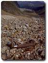
In late 1945 the little Estelette glacier (at the feet of the Aiguille des Glaciers) was the theater of a still unclear accident. A B29 bomber of the US Air Force, apparently flying back from a classified mission, crashed into the moraine during a thunderstorm. American authorities had the valley closed for weeks while the area was searched. The reasons for such secrecy have not been yet revealed, but locally wild rumours about what was inside the airplane (for instance, a huge gold cache) continued for years .The Estelette airplane is the "other" notorious plane crash in the area - the most famous being the Malabar Princess disaster in 1950
Remains of the unfortunate airplane are still dispersed on the Estelette moraine (20 minutes above the Elisabetta hut), and the progressive retreat of the glacier reveals new fragments each year.
 |
External Links
- Traverse of the Lex Blanche horseshoe
A magnificent slideshow of the traverse of the Petit Mont Blanc, Aig. De L'Aigle, Trelatete, Lex Blanche and Aig. Des Glaciers until the Col De La Seigne, made in 18h30m of continuos climbing. With music!