
-
 125991 Hits
-
 95.67% Score
-
 54 Votes
|
|
Mountain/Rock |
|---|---|
|
|
45.93324°N / 6.95539°E |
|
|
Mountaineering, Trad Climbing |
|
|
Summer |
|
|
12316 ft / 3754 m |
|
|
Overview
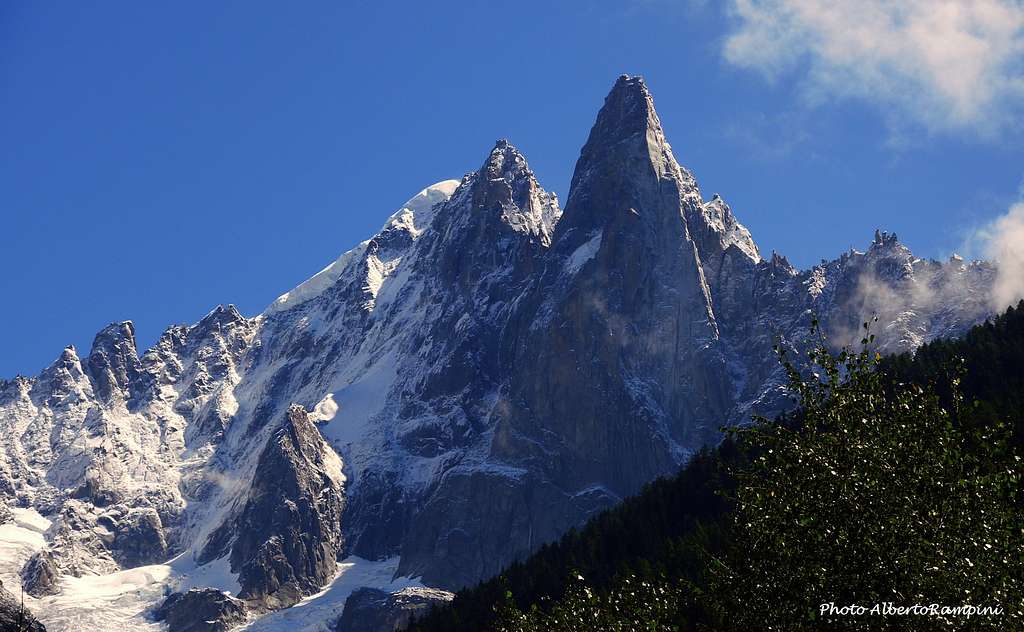
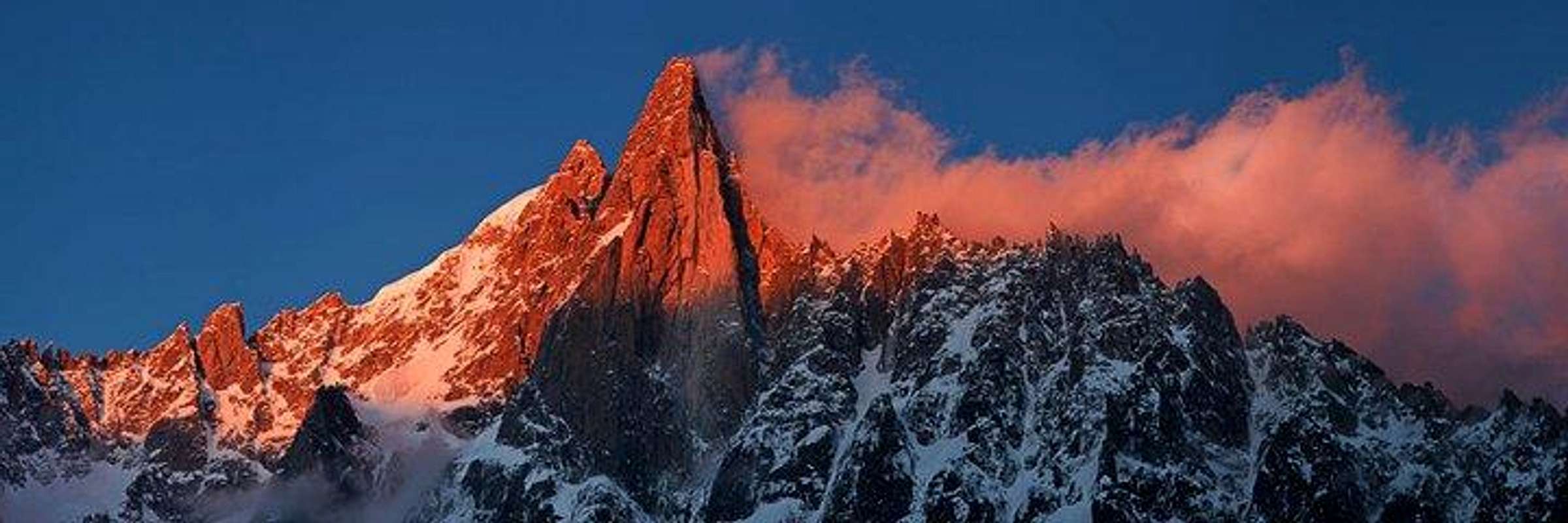
Aiguilles du Dru 3754 m
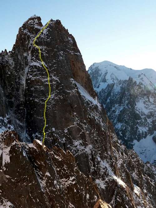
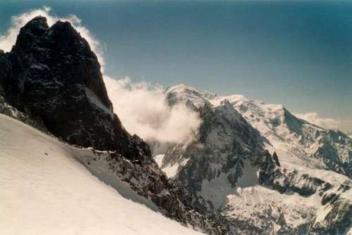
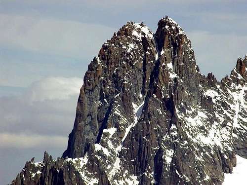
The Aiguilles du Dru - also commonly named Les Drus - are a colossal rocky pyramid belonging to the Mont Blanc Massif and situated on its Northern side, entirely in French territory. Precisely Les Drus are located to the West in the sector Aiguille Verte, from which are separated by a deep notch and a long ridge. Although from a distance it looks like a monolith, it is actually composed of two nearby but separate summits. The Petit Dru 3733 m is the lower one, its neighbour is a few meters higher and is called Grand Dru 3754 m. The two peaks are separated by the Brèche du Dru 3697 m.
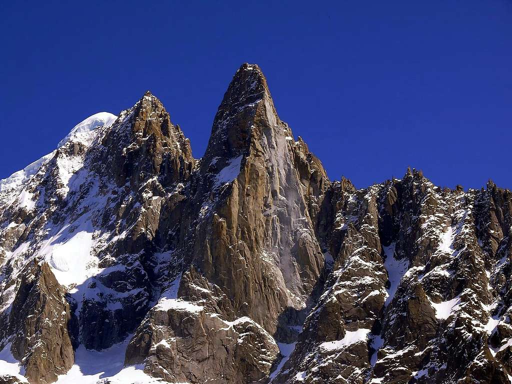
In Europe and especially in France and Italy the Aiguilles du Dru are a kind of legend due to their stunning beauty, their importance in the mountaineering history and the plentitude of severe routes on their walls. From the railway station in Montenvers the impression of the Petit Dru is especially overwhelming. The mountain is situated a little East of Aiguille Verte. Even the easiest route on the Petit Dru is graded "D" in French scale. Les Drus are predominantly a rocky mountain, but there is a very serious ice route on them as well.
The name of the Petit Dru is strongly linked to that one of the great Walter Bonatti who completed the first ascent of the formidable SW pillar, that since then took the name of Pilier Bonatti. Between 17-22 August 1955 Walter Bonatti solo climbing opens a new route on the South-West pillar in six days, 600 m / TD +, A1. This route has been one of the greatest exploits in the history of mountaineering. Unfortunately the pillar collapsed after the repeated landslides between June and September 2005.

History

The first ascent of the Grand Dru was accomplished on September 12, 1878 by Clinton Thomas Dent and James Walker Hartley, with the alpine guides Alexander Burgener and Kaspar Maurer. The following year was carried out also the first ascent of the most difficult Petit Dru, which was completed by Jean Charlet-Straton, Prosper Payot and Frédéric Folliguet on August 29, 1879. E. Giraud, J. Ravanel, A. Comte, 1903, September 6
The first complete crossing of the two summits by fair means took place by E. Fontaine with Joseph and Jean Ravanel on 23 August 1901.
In the year 1935 Pierre Allain and Raymond Leininger performed the first ascent of the North Wall of the Petit Dru by climbing the route Allain-Leininger, considered one of the six classic North faces of the Alps.
The first route on the stunning West wall was realized by Guido Magnone, Lucien Berardini, Adrien Dagory and Marcel Lainé in 1952. The route was climbed in two separate attempts; to finish off the route, in the second attempt the first climbers used a rather unethical style: the route was continued starting from the middle of the wall and using the route Allain-Leininger. For this reason the team was subject to criticism.
The most extraordinary and celebrated mountaineering exploit was the one performed by Walter Bonatti, that after six days of hard solo ascent managed to win the SW Pillar, later renamed Pilastro Bonatti.
In the Sixties the West wall registered two great exploits realized by US teams: the American Direct in the year 1962 by Gary Hemmings and Royal Robbins and the American Directissime in the year 1965 by John Harlin and Royal Robbins again.

|

|

|
Getting There
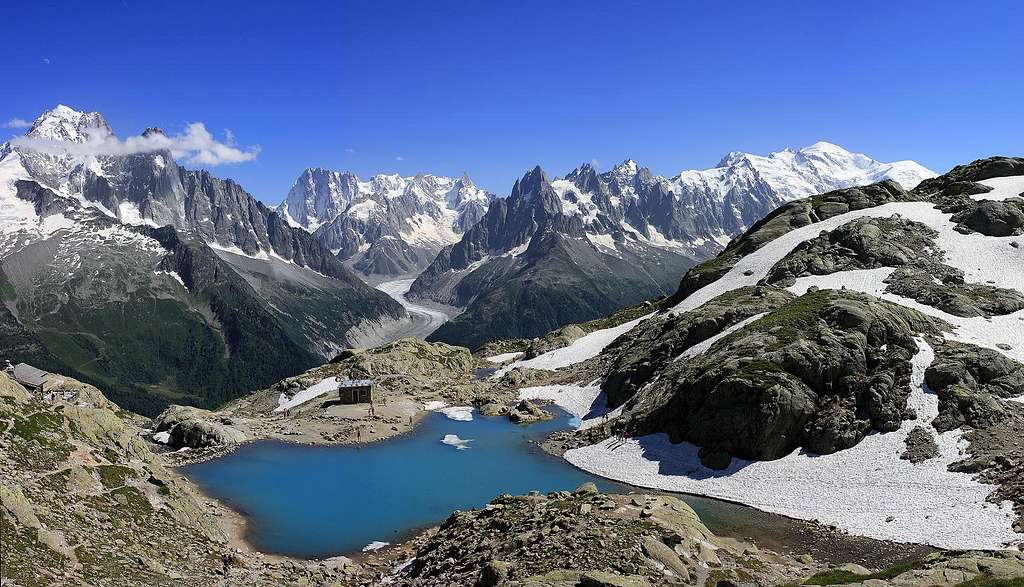
The valley of Chamonix is the place to get started for any of the routes on Les Drus. There are two ways to approach Les Drus.
") |
 |
 |
 |
One is by rail, directly from the town of Chamonix to the railway station at Montenvers 1913 m (mer-deglace.com). The other one is also accomplished by mechanical means, namely the "Téléphérique de Lognan et des Grands Montets" (grands-montets.com) which departs between the villages of Les Chosalets et Argentière, not far to the northwest of Chamonix. The téléphérique leads to the Aiguille des Grands Montets (3295 m).

The approach via Montenvers is used for all the routes on Les Drus. The approach via Grands Montets is only used for the routes on the North and West faces.
A map is indispensable to find your way about. Recommended is the French map of the IGN, 1/25000, nr. 231. An other item you can't do without in the Mont Blanc region is the "Guide Vallot", two books in which you can find most of the routes, as well easy ones as the very hard ones. The one you need for Les Drus in particular is part 2.
For the routes on the South side of the mountain you can spend the night in the "Refuge de la Charpoua" 2841 m, a very small and charming hut. It only gives shelter at about 12 persons. Reservation is obligatory (33 (0) 4 550 53 00 88). From the railway station at Montenvers 1913 m you descend to the Mer de Glace, a glacier that you cross to the south, then southeast. You gain the right (North) border of this glacier, southwest of point 2082 on the map. You climb some glacier debris (yellow marks). You'll find the path pretty easy. You mount the "Rognon de la Charpoua" until you reach the hut. You'll need about 3 to 4 hours to reach the hut from Montenvers. Mounting is somewhat tiresome, some parts are secured with steel cables. Some mountain experience is required! If you want to climb a route on the North or the West side of the mountain you'll have to bivouac in the open sky, for on this side there is no hut available. The site commonly used to spend the night is the "Rognon du Dru". This rocky isle is situated between the "Glacier du Nant Blanc" and the "Glacier des Drus". From Montenvers you cross the Mer de Glace plain east, then mount the flanks beneath the Nant Blanc- en the Drusglacier. About 2,5 to 3 hours of ascending. From Grands Montets there are different ways to reach the Rognon du Dru, but it all comes down to crossing two glaciers and a rocky part that separates the two. This routes are descending. You'll need 1 to 2 hours.

|

|

|
Routes overview

- Grand Dru - Normal route, difficulty AD
- Grand Dru - South face, Voie Contamine, difficulty TD, 6a+ (6a obbl.), 650 m - M. Bastien and André Contamine, 1952, June 30 - First winter ascent: N. Jaeger 1974 - Excellent rock and route sheltered from falling rocks. Athletic and sustained climbing.
- Grand Dru, South face, Pilier du Trident, difficulty TD+, 6b (5c obbl), 700 m - Les Auvergnats Collangettes et Frachon, 1978, September 21
- Grand Dru, South face, Stembert pillar, difficulty TD
- Petit Dru, Normal route, difficulty D-, IV (5c a move), 400 m - Jean Charlet-Straton, Prosper Payot and Frédéric Folliguet 1879, August 29
- Petit Dru, South west Pillar, Pilastro Bonatti, difficulty ED+ (free) - the route is no longer climbable due to the collapses on the wall
- Petit Dru, West face, French directissime, difficulty ED+
- Petit Dru, West face, American direct, difficulty ED-, 6c (6b obbl), 1000 m - Gary Hemming and Royal Robbins 1962, July 24-26 - "Classy" route, sustained, steep and athletic. It asks for a good physical condition and a good habit of crack climbing. The sun appears quite late on the route.
- Petit Dru, West face, American directissime, difficulty EX - John Harlin and Royal Robbins 1965, August 10-13
- Petit Dru, North face, Allain-Leininger route, difficulty TD+, 5c, 850 m - Pierre Allain and Raymond Leininger 1935 - Very steep rocky route mainly on cracks, severe, mixed in the last 6 lengths.
- North east great couloir, difficulty TD+, ice up to 80°
- Petit Dru, Destivelle route, difficulty VI, A5 - Catherine Destivelle in solo climb 1991, June
- Petit Dru, Lafaille route, difficulty aid climbing till A5+ - Jean-Christophe Lafaille in solo climb 2001, February 12-20
- Traverse of Petit and Grand Dru, difficulty D, 5c A0, 500 m - J.E. Charlet-Straton, P. Payot, F. Folliguet, 1879, August 29 / E. Giraud, J. Ravanel, A. Comte, 1903, September 6 The last undertaking on the mountain is a route realized by the Spanish alpinists David Palmada and Josep Maria Esquirol between the Bonatti on the extreme right of the West wall and the route of the Americans Gary Hemming and Royal Robbins, on the left (winter 2015). More info: La terza via che ha conquistato il mitico Petit Dru.
- Petit Dru, "Petit Jean" (Polish route), difficulty TD sup (Lenghts VI/A1) - Jerzy Kukuczka, Voytek Kurtyka, Marek Lukaszewski 10-14 August 1973. First Winter Ascent: Slavo Drlik and Jaromir Stejskal, 26 February - 5 March 1976 - The Route is dedicated to Jan Franczuk ("Little Jan"), who disappeared on Kunyang Chhish in 1971.
Red Tape
No fees no permits required.
The rockfalls

|

|
While describing this marvelous peak it's useful to mention the various rock-falls to which unfortunately the stunning West face had been subjected, as the collapses compromised the possibility of climbing some routes on this wall. In fact, over time, the West wall repeatedly recorded some rock collapses, including the most disastrous in 2005, affecting most of the Pilastro Bonatti and the last in 2011. See here on SP the complete history of the rock-falls on the West wall of Petit Dru, starting from the small one in the year 1905, in this interesting article by ericvola: The Fall of the Alps.
See here another interesting article about the topic: The West Face of Les Drus (Mont-Blanc massif): slope instability in a high-Alpine steep rock wall since the end of the Little Ice Age - by Ludovic Ravanel and Philip Deline (in English)
Other info about the rock-fall of 2011: see Montagna TV (in italian).

When To Climb
While Les Drus are a rocky mountain its preferably climbed in summer. Depending conditions very steep routes like those on the westface can be relatively quick snowfree.
 |
 |
 |
Accomodation
Chamonix is a primary destination, offering various kind of accomodation (hotels, huts, gites, renting rooms). Numberless campsites are situated both in the Northern and Southern ends of the town. Main campsites:
- Camping la Mer de Glace - Les Praz (3 km. North to Chamonix) +33(0)450534403
- Camping les Deux Glaciers - Les Bossons (3 km. South to Chamonix) +33(0)450531584
- Camping les Arolles - close to the centre of Chamonix - +33(0)450531430
- Camping les Cimes - Les Bossons (3 km. South to Chamonix) +33(0)450535893
- Camping les Marmottes - +33(0)450536124
- Camping Glacier d'Argentière - Argentière (8 km. North to Chamonix) +33(0)450541736
General info
- Office de la Haute Montagne de Chamonix Phone +33 0450 532208 - - Office de la Haute Montagne de Chamonix
- Cable-car informations Phone +33 0450 532275 Compagnie du MontBlanc
- Office du Tourisme de Chamonix Phone +33 0450 530024 Chamonix Mont-Blanc
Meteo and Mountain Conditions
You can get excellent information about weather, conditions and routes at the "Compagnie des Guides de Hauts Montagnes" or the "Maison de la Montagne" at the "place de l'Église" in Chamonix. Don't be afraid to step into their building, its common practice, people are constantly walking in and out. By no means you are expected to hire a guide when you visit. For weather reports you can call 50 53 03 40. In winter the number 50 53 17 11 gives snow conditions and avalanche risks. Mountain rescue is secured by the "Gendarmerie de Haute Montagne", 50 53 16 89.
Guidebooks and maps
"Monte Bianco Vol. 2" Guida Vallot by François Labande
"The Mont Blanc Massif - The 100 Finest Routes" by Gaston Rebuffat - London 1996
Map
3630 OT (Chamonix) Institut Géographique National - 1:25000