
|
|
Mountain/Rock |
|---|---|
|
|
42.16999°N / 111.58964°W |
|
|
Bear Lake |
|
|
Hiking |
|
|
Spring, Summer, Fall, Winter |
|
|
9311 ft / 2838 m |
|
|
Overview

Bloomington Peak from Bloomington Lake
Peak. It has the best view of Paris Peak by far and also offers and amazing view of Bloomington Lake and St. Charles Mountain which are on the opposite side of Bloomington Canyon.
Although this peak is not technically difficult it does offer a rewarding and beautiful climb. All approaches are relatively smooth except for the north side which is nearly vertical in some places and offers a series of cliffs and rock. There is a large cirque at the base of the north side. Climbing from this direction could offer many more challenges and could border on a class 3 climb in some places. The most feasable route would be from the south. There is no trail and the brush is quite thick in some places so it will be a bushwhack from any direction. The base of the mountain is at about 8000 ft. from all directions so there is a little more that 1300 ft. of elevation gain in less than a mile.
In June of 1998 there was a severe storm which, amazingly, produced a tornado in the upper-central portion of Bloomington Canyon. The tornado ripped down several square acres of timber and left the area nearly treeless. The Forest Service opened the area for logging to clean out the dead timber and what was left after that was burned. For this reason you will see a lot of uprooted and burned stumps in this portion of the canyon.
Getting There
From Logan, UT
Take 400 North in Logan which will turn into highway 89 and take you through Logan Canyon. Turn North when you get to Garden City, UT and continue across the Idaho border until you get to the small town of Bloomington.

Getting There
From Preston, ID
State Street (Highway 91) in Preston divides at the town's northern end. Take the right division and head northeast on Highway 34. You will follow this highway for about 5 miles until you drop into the river bottons of the Bear River. The road will cross the river and you should turn right on Highway 36, just past the river crossing. Follow this road all the way through the mountains until you get to Ovid, ID. At the Ovid junction turn South on Highway 89 and continue until you reach the town of Bloomington. From there follow the directions below.
Bloomington Canyon

Telegraph Flat
The Climb
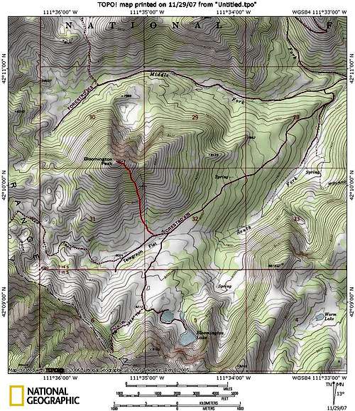
South Ridge Route

The Center Ridge of the South Face.
When To Climb
Bloomington Peak can be climbed during any season. The approach to the mountain will vary though. During the summer you can simply drive to the base of the mountain. Depending on the weather in the spring and fall you will be able to as well. There are some times when the road is muddy though. The road is generally closed November 15th due to snow except when there is little snow fall. (This year for example) It usually reopens in early to mid May as well. The typical snow-free season is late May/early June to late October/early November. This varies from year to year as well. If you wish to climb the mountain during the winter the road will be open up to the Paris Peak trailhead. From there you must either ski, snowshoe, or snowmobile to the peak. Bloomington Canyon is also a popular snowmobiling area in the winter as the road becomes a groomed trail that connects with other popular trails throughout the Bear River Range. It is possible to take a snowmobile to the summit of Bloomington Peak when snow is sufficient on its sun-exposed south face. The North face poses a significant avalanche risk though because of it's steepness.
Camping
There are some excellent camping places in Bloomington Canyon. The best and most beautiful place is probably the semi-developed Bloomington Lake parking area. There are restrooms there and there are a few great spots in the trees with fire rings. There are no tables and no potable water unless you bring a filter, then there's plenty. It is a very heavily used area in the summer so finding one of these spots open during the peak summer months might be a challenge.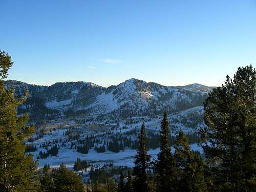
St. Charles Mountain
External Links
Bloomington Peak is in the Caribou-Targhee National Forest.Red Tape
There are no fees or permits of any kind required to access this area. The road is well maintained as well. The one drawback is Bloomington Canyon's popularity. You will undoubtedly see many people on the road and at Bloomington Lake. Bloomington Peak, however, is seldom climbed and so you can expect to be alone for the climb and on the summit.
Sunset on St. Charles