
-
 17119 Hits
-
 94.63% Score
-
 48 Votes
|
|
Mountain/Rock |
|---|---|
|
|
41.83330°N / 111.7017°W |
|
|
Cache |
|
|
Hiking, Scrambling |
|
|
Spring, Summer, Fall, Winter |
|
|
9566 ft / 2916 m |
|
|
Overview
 Mount Jardine
Mount Jardine is among the highest peaks in the southern portion of the Bear River Range. The mountain is south of Naomi Peak and Tony Grove and northwest of Logan Canyon. Mount Jardine is connected to the same ridge as Mount Elmer which is located farther north. They form a rugged ridgeline above several canyons. There are several routes up the mountain. Green Canyon is the most popular route in summer and winter. There are two other routes from the west. Birch Canyon is northwest of Mount Jardine and is the most beautiful approach up the mountain. The next canyon located south is Smithfield Dry Canyon. The trail up this canyon meets up with Birch Canyon at a saddle located between Flat Top and Mount Jardine.
The Bear River Range is a long chain of mountains that form the northern extension of the Wasatch Range. They run in a north to south direction from Soda Springs, Idaho to Logan, Utah. The highest mountains south of Naomi Peak are Logan Peak, Mount Elmer, Mount Jardine, and Flat Top Mountain. Then the mountains becomes more rounded and are lower in elevation until it reaches the southern tip of the range near Sharp Mountain and James Peak. The highest peaks are over 9,000 feet in elevation. They vary from rolling hills to summits surrounding by cliffs. Standard routes are usually no harder than class 2 but more difficult routes can also be found. Some of the most interesting peaks remain unnamed and are seldom climbed.
Mount Jardine was named after Secretary of Agriculture, William Marion Jardine. He was born in Oneida County, Idaho, on January 16, 1879. He attended Utah State College of Agriculture, which is now Utah State University, receiving his BA in 1904. He then attended graduate school at the University of Illinois in 1906 and was appointment as assistant professor of agronomy at Utah State. Jardine later taught at Kansas State University. He served as assistant U.S. cerealist from 1907 to 1910. While at Kansas State, Jardine became director of the Agriculture and Agronomy School and later dean of the School of Agriculture in 1913. In 1925, President Coolidge appointed Jardine as Secretary of Agriculture, a position he held until 1929. In 1930, Jardine was appointed as U.S. minister to Egypt. He returned to serve as president of the University of Wichita from 1934 to 1949. Jardine died on January 17, 1955.
The most well known geographical feature to be named after William M. Jardine is the Jardine Juniper. It is one of the oldest trees in Utah. The tree is located on the west side of Logan Canyon southeast of Mount Elmer and Mount Jardine. It is a popular trail in the Bear River Range. The tree is still alive but growing at a very slow rate. A good view of the main ridge of the Bear River Range can be seen from the trail. The trailhead is located at the parking area near Wood Camp which can be reached from Logan Canyon. It is a leisurely day hike or bike ride to get to the tree and many people see it each year. There are several of these ancient trees in the area. The Jardine Juniper sits on the edge of a cliff near a small platform with a great view of the surrounding area.
Getting There
All of these trailheads can be reached by driving a short distance from Logan, Utah. Green Canyon is open to everyone. The mouths of Birch Canyon and Smithfield Dry Canyon may be gated and access to these canyons may change at anytime.
 Green Canyon
Green Canyon Trailhead:
Drive on I-15 north of Brigham City and take exit 362 (US-91/Logan). Keep driving on US-91 through Sardine Canyon. After 25 miles US-91 will merge into Main Street in Logan. Continue driving to the city of North Logan. Turn right at 1900 North and go passed K-Mart. Drive east and the road will turn into 1900 North. Keep driving on this road and there will be a parking lot about 1 mile or so near the mouth of Green Canyon. This is the winter trailhead and any vehicle can be driven here. From this lower winter trailhead it is an extra 3.7 miles of hiking and 1,000 feet of elevation gain. July to November 15, a dirt road continues for 3.75 miles to the upper parking lot. It is in good condition but some cars may find it a little rough.
Birch Canyon Trailhead:
Drive on I-15 north of Brigham City and take exit 362 (US-91/Logan). Keep driving on US-91 through Sardine Canyon. After 25 miles US-91 will merge into Main Street in Logan. Continue driving north to the city of Smithfield. Turn east on 100 North Street. Drive two blocks east and then a half block south to Canyon Road. Follow this road east and then northeast for a mile. Turn right onto Birch Canyon Road. There should be a sign marking the way. Follow this windy dirt road for a mile to the mouth of Birch Canyon and a locked gate. This is where the trailhead is located which is about 0.25 mile from the national forest boundary. You will have to park on the side of the road. There is private land and homes near the mouth of the canyon so only stay on the main road.
Smithfield Dry Canyon Trailhead:
Drive on I-15 north of Brigham City and take exit 362 (US-91/Logan). Keep driving on US-91 through Sardine Canyon. After 25 miles US-91 will merge into Main Street in Logan. Continue driving north to the city of Smithfield. Turn right onto 300 South Street as you enter Smithfield and drive east. The road will turn into dirt and you can drive as far as possible. The owner had previously closed off vehicle traffic because ATV’s and dirt bikes had run all over the slopes of his property. You can walk the final part to the actual trailhead where you will see a gate and sign that says Mount Naomi Wilderness on it. Remember to close all gates that you pass through.
Routes Overview
There are three main routes that go to the summit of Mount Jardine. All of them are located on the west side of the range. The entrance to Green Canyon is located east of the city of North Logan. Birch Canyon and Dry Canyon are located east of the city of Smithfield.
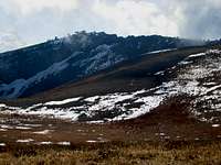
 Mount Jardine Summit
Green Canyon
Green Canyon is the most popular route to the summit of Mount Jardine. The elevation gain is gradual even though it is a long canyon. Its name originates from the healthy growth of green vegetation that located in the canyon. The trail through the canyon is in good condtion to about 8,500 feet. Then is begins to fade away. At the junction that is located between Mount Elmer and Mount Jardine you will have to leave the trail and climb up the ridge between the two peaks. Mount Jardine in located to the south. There was some water in the canyon but I would carry it anyway since it was mostly dry. In my opinion, this is the best route to use if you want to climb Mount Elmer and Mount Jardine in one day. It is also the safest route to use in winter. The trail is packed down for the first couple miles to the summer trailhead. The trail is open to hikers, skiers, snowshoers, and mountain bikers.
Summer: Distance is 6.35 miles from the upper trailhead to the summit with 3,600 feet elevation gain.
Winter: Distance is 10.1 miles from the lower trailhead to the summit with 4,875 feet elevation gain.
Birch Canyon
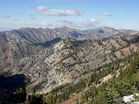 Mount Jardine View
This is the most scenic route up Mount Jardine. The canyon has a year round stream flowing through it. The lower section of Birch Canyon has good campsites while the upper section is limited. A half mile past the forest boundary the jeep road becomes a trail. You will be crossing the stream several times during the hike. During this time, the trail passes through vegetation zones of cottonwoods to maple and aspen trees. There will be meadows of Douglas fir and subalpine fir. The trail goes up through series of bowls below high limestone cliffs below Mount Elmer and Mount Jardine. About five miles from the trailhead the trail climbs up to the top of the saddle that divides Birch Canyon from Smithfield Dry Canyon. Flat Top Mountain will be west and Mount Jardine will be to the east of the saddle. Follow the ridge toward Mount Jardine. This is a little scrambling involved on the ridge to the summit.
Distance is 6 miles from Birch Canyon trailhead to the summit with 4,100 feet elevation gain.
Smithfield Dry Canyon
The name of this canyon is Dry Canyon but Smithfield is usually included in the name. This is to distinguish it from another Dry Canyon located below Logan Peak. The trail starts through a rather narrow canyon but opens up as you get higher. The route starts by following an old jeep road. Then it becomes a hiking trail farther up the canyon. The creek will contain some water in it but may be dry during the middle of summer. Red Ledge Spring is about 2.5 miles from the wilderness boundary. Approximately a mile beyond Red Ledge Spring you encounter the trail that goes down Birch Canyon and back to Smithfield. At 9000 feet, in the direction of Mount Jardine, the main trail turns sharply to the south but shortly turns northeast, avoiding the peak that is only about 0.25 miles away. You can leave the trail from here and climb directly up the north ridge of Mount Jardine.
Distance is 5.7 miles from Smithfield Dry Canyon trailhead to the summit with 4,250 feet elevation gain.
Jardine Juniper
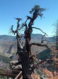 Jardine Juniper
 Jardine Juniper Trail
Jardine Juniper Peak
The Jardine Juniper is the oldest known living tree in Utah. It is estimated to be over 3,000 years old. The tree sits on the edge of a limestone cliff overlooking the valley. It is located on the southeast side of Mount Elmer and Mount Jardine. Utah State student, Maurice Linford, discovered the Jardine Juniper in 1923. They named the tree in honor of William M. Jardine. It is unknown as to whether Jardine actually visited the tree that bears his name today.
Getting There: Drive on I-15 north of Brigham City and take exit 362 (US-91/Logan). Keep driving on US-91 through Sardine Canyon. After 25 miles US-91 will merge into Main Street in Logan. Drive to the intersection of Main Street and 400 North in Logan. Turn east on Highway 89 into Logan Canyon. Drive for about 12 miles to the exit to Wood Camp. Turn here and cross the bridge at Wood Camp to the small parking area.
Trail Description: A maintained trail goes to the Jardine Juniper. The trail crosses a stream bed near the beginning and again at about 1.5 miles on the south side of an open area. Then the trail starts to gain elevation through a series of switchbacks. This section of trail is particularly outstanding from late September to early October when the Fall colors are in season. The trail divides at the ridge above Cottonwood Canyon. The left fork goes to the upper part of the canyon. Take the right fork to the juniper. The trail divides at about 4 miles to go around a hill. The left fork overlooks Cottonwood Canyon, the right fork overlooks the Logan Canyon area. The trails rejoin about 1000 feet from the juniper, and switchbacks take you down to the tree which is located near a wooden platform. There is a sign that says: This Rocky Mountain Juniper has been active for 3,200 years. With respect it will survive many more. Please enjoy this tree from a distance. Hiking distance is about nine miles round trip. Also, you may want to hike to the summit of Jardine Juniper Peak while you are there. It is the tree covered summit located a short distance above the trail leading to the juniper.
When to Climb
 Green Canyon
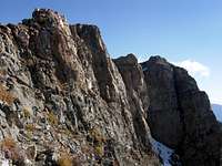 Summit Ridge
Mount Jardine is best climbed during the summer months from July through September.
The mountain can be climbed all year since the road to Green Canyon is open to the lower trailhead. It would be a long day to climb Mount Jardine from here in winter. The mountain can also be climbed in late spring and early fall depending on snow conditions. In normal years, snow last in early summer. Many people who have climbed nearby Naomi Peak in early July have encountered a lot of snow at the higher elevations. In fall, there are few people out hiking until October when hunting season takes place.
In winter, the distance from the lower trailhead to the upper trailhead is 3.75 miles. This is packed down pretty good much of the time by snowshoers and skiers. There are several yurts located at different locations in the Bear River Range. One of them is located in Green Canyon. It is assembled and dismantled at the beginning and end of winter unlike the other yurts that stay up year round. Each yurt holds a wood-burning stove, a kitchen and sleeping bunks for as many as 12 different people. Any yurt excursion requires travel by snowshoe or cross-country skis. Renting a yurt costs anywhere from $50-$170 a night, depending on the day of the week and the number of days you are staying. Utah State University students can get a discount off the basic rate. Here is more information on the Green Canyon Yurt
Red Tape
 North Ridge
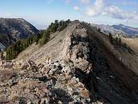 North Ridge
Mount Jardine is located in Wasatch-Cache National Forest
There are no fees for climbing Mount Jardine.
The only Red Tape for climbing this mountain is negotiating the private property located near the mouth of Birch Canyon and Smithfield Dry Canyon. Access to these areas may be closed at anytime. Most of the problems are due to ATV’s and not hikers. Just use common sense and close all gates, park off the side of the road, and don't disturb anyone else's property when hiking in these canyons.
The Wasatch-Cache National Forest Headquarters is located at 8236 Federal Building, 125 South State Street in Salt Lake City, UT 84138. Phone (801) 236-3400.
Logan Ranger District is at 1500 East Hwy 89 in Logan, UT 84321. Phone (435) 755-3620.
Camping
 Mount Jardine
Backcountry camping is allowed in all of the canyons located below Mount Jardine. Green Canyon has good places to camp along the way. The lower portions of Birch Canyon and Smithfield Dry Canyon provide nice campsites. Be sure to hike at least a mile above the mouth of these canyons. You must be 200 feet away from any road, trail, or water source. The dispersed camping limit in one spot is 16 days. If you would lake to stay at a campground, there are several located along the Logan Canyon Scenic Byway. Some of them are first come, first serve and others can be reserved online. Campgrounds are usually open from Memorial Day to mid-October. Tent camping is between $18 to $20 a night.
Spring Hollow Campground is located 4 miles up the west side Logan Canyon. It is near the Logan River and Spring Hollow Creek. There are 12 sites available. Guinavah Campground is 5 miles up the west side of Logan Canyon. It is located in the forest near the Logan River. There are three loops that have a total of 40 sites. Tony Grove Campground is the most popular place to camp in Logan Canyon. It is about 18 up Logan Canyon at an elevation of 8,100 feet. The campground has 37 sites. Sunrise Campground is located 6 miles west of Bear Lake and 1 mile east of Bear Lake summit. It sits at an elevation of 7,800 feet. There are 27 sites available here. Nearby Logan Canyon Campgrounds: Spring Hollow Campground and Sunrise Campground
Books
Utah Mountaineering Guide
By Michael R. Kelsey. There is a short description about climbing Mount Jardine in the Bear River Mountains section of the book.