
-
 18112 Hits
-
 95.97% Score
-
 56 Votes
|
|
Mountain/Rock |
|---|---|
|
|
41.93114°N / 111.65492°W |
|
|
Cache |
|
|
Hiking, Scrambling |
|
|
Spring, Summer, Fall |
|
|
9714 ft / 2961 m |
|
|
Overview
 Mount Gog
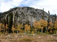
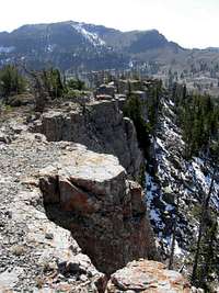
Mount Gog is located in the heart of the Bear River Mountains. It is among the highest peaks in the range. Despite its location, the mountain is not climbed often. Mount Gog will always be linked with its neighbor Mount Magog. The two mountains have a very different appearance. Mount Gog is a large peak with a flat summit plateau and impressive south face. Mount Magog is more dramatic with a pointed summit and steep cliffs on its north face. The first ascent of Mount Gog was made by members of the Hayden Survey.
The regular route up the mountain starts from Tony Grove trailhead and then goes toward White Pine Canyon. This trail goes over a ridge overlooking the valley. You must climb back up this on the return trip. It is a nice four mile hike to White Pine Lake. The lake is located in a nice setting below vertical limestone cliffs between Mount Gog and Mount Magog. The standard route goes around the lake and climbs up boulders and talus up the tree covered ridge on the southwest side of the mountain. The summit view is very good including the highest peaks in the area.
The Bear River Range forms the northern extension of the Wasatch Range. The highest named mountains in the range include Naomi, Doubletop, Cherry, Magog, and Gog. These mountains are located south of the Idaho border and north of Tony Grove in Logan Canyon. With the exception of Naomi Peak, all of the mountains are seldom climbed. This is a great area with many mountains and lakes. Numerous peaks reach above 9,000 feet in elevation. They vary from rolling hills to summits surrounding by limestone cliffs. Mountains are usually no harder than class 2 off-trail hiking but more difficult routes can also be found.
Gog is an unusual name for a mountain. Mount Magog is located farther south on the main ridgeline. Both mountains were named from the Bible and have an interesting history. They were often associated with a prophecy of the apocalypse. Most of the time, they are shown depicting good against evil. There is a lot of confusion about their names and how they were related. Sometimes it is the name of a person, and sometimes it is the name of a nation. Sometimes Gog and Magog are described as brothers, and sometimes Gog is the king of the Magog.
Getting There
 Mount Gog
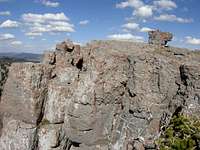 Mount Gog Summit
Drive on I-15 north of Brigham City and take exit 362 (US-91/Logan). Keep driving on US-91 through Sardine Canyon. After 25 miles US-91 will merge into Main Street in Logan. Drive to the intersection of Main Street and 400 North in Logan. Turn east on Highway 89 into Logan Canyon. Drive for about 18 miles to the exit to Tony Grove. Turn here and follow this road for 7 miles to the trailhead and also the parking lot for Tony Grove Lake.
You can also get here if you are coming from the northeast near the cities of Soda Springs or Montpelier in Idaho. Turn onto Highway 89 and drive south toward Garden City. In town, turn onto the road leading up into Logan Canyon. Go over the summit of the canyon and then drive several miles to the signed road junction leading to Tony Grove. Drive up this windy paved road for approximately seven miles to the trailhead.
Routes Overview
All of these routes start from Tony Grove Trailhead but diverge at a junction a short distance later. The southwest ridge route is reached from White Pine Canyon. The other route goes up the trail toward Naomi Peak. They can be combined together as a loop.
 Magog seen from Gog
Southwest Ridge
This is the shortest route to the summit of Mount Gog. This trail goes over a ridge overlooking the valley. You must climb back up this on the return trip. It is a nice four mile hike to White Pine Lake. The lake is located in a nice setting below the vertical walls between Mount Gog and Mount Magog. The route climbs up the Southwest Ridge of Mount Gog. This is located to the left of the large south face. The summit is located on top of limestone cliffs. There are great views of all of the highest peaks in the range. Mount Gog can also be climbed with Mount Magog or Naomi Peak in the same day. Distance is 5 miles from the trailhead to the summit via the Southwest Ridge with 2,650 feet elevation gain.
Gog to Naomi Traverse
 Magog and Gog
This route traverses the ridge between the two summits. It can also be done in the opposite direction from Magog to Gog. From the summit of Mount Gog, you will notice the long ridge that is to the west. The ridge is entirely off trail and is rated class 2. You will loose some elevation down climbing the west ridge of Mount Gog. It goes west toward the ridge that is located south of Bullen Hole Peak and then south toward Peak 9,350. The ridge will eventually get to the saddle that is north of Naomi Peak which will be a short distance away. You can follow the Naomi Peak trail down to the trailhead from here.
Gog to Magog Traverse
The most direct route from Mount Gog to Mount Magog is the lower elevation ridge above the cliffs near White Pine Lake. The ridge itself is a short distance with good views. The face below Mount Magog requires some 3rd class scrambling to find the easiest route through the cliff bands on the northwest side of the mountain. The best route up Mount Magog is from the south. Follow the ridge through short rock walls and trees. The summit is located on a large square block. After climbing the mountain you can descend and hike south to reach the Naomi Peak trail that goes back down to the Tony Grove Trailhead.
When to Climb
 South Face
 Southwest Ridge
The main climbing season for Mount Gog is during the summer months. This is July through mid-September.
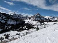
The mountain can also be climbed in late spring and early fall depending on snow conditions. In normal years, snow last in early summer. Many people who have climbed nearby Naomi Peak in early July have encountered a lot of snow at the higher elevations. In fall, there are few people out hiking until October when hunting season takes place. Tony Grove can be accessed in winter by skiing or snowshoeing. The road is seven miles in distance from Logan Canyon to the trailhead.
Logan, Utah Weather Forecast
Red Tape
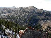 Bullen Hole Peak
 Mount Gog
There is a $6.00 parking fee at Tony Grove Trailhead.
It should also be noted that you can park down lower in the campground. If you have an America The Beautiful Pass then it is free to park here. This just adds a small amount of walking distance.
Mount Gog is located in Wasatch-Cache National Forest
Logan Canyon is plowed in winter but the road to Tony Grove is not. Snowmobiles pack down the road to the trailhead. It would be a long distance to climb Mount Gog in winter so this is rarely done. Check winter road conditions at the UDOT website.
The Wasatch-Cache National Forest Headquarters is located at 8236 Federal Building, 125 South State Street in Salt Lake City, UT 84138. Phone (801) 236-3400.
Logan Ranger District is at 1500 East Hwy 89 in Logan, UT 84321. Phone (435) 755-3620.
Camping
 Naomi Peak
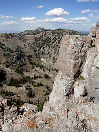 Doubletop Mountain
The best place to camp near the mountain is at White Pine Lake. There are sites with fire rings on the east and north side of the lake. Backcountry camping is allowed in undeveloped sites. This must be 200 feet away from any road, trail, or water source. The dispersed camping limit in one spot is 16 days. There are several campgrounds located along the Logan Canyon Scenic Byway. Some of them are first come, first serve and others can be reserved online. Campgrounds are usually open from Memorial Day to mid-October. Tent camping is between $17 to $19 a night.
Spring Hollow Campground is located 4 miles up the west side Logan Canyon. It is near the Logan River and Spring Hollow Creek. There are 12 sites available. Guinavah Campground is 5 miles up the west side of Logan Canyon. It is located in the forest near the Logan River. There are three loops that have a total of 40 sites. Tony Grove Campground is the most popular place to camp in Logan Canyon. It is about 18 up Logan Canyon at an elevation of 8,100 feet. The campground has 37 sites. Sunrise Campground is located 6 miles west of Bear Lake and 1 mile east of Bear Lake summit. It sits at an elevation of 7,800 feet. There are 27 sites available here.
Lower Logan Canyon Campground Reservations: Spring Hollow Campground and Guinavah Campground
Upper Logan Canyon Campground Reservations: Tony Grove Campground and Sunrise Campground
External Links
 Mount Gog
 Gog seen from Magog
Gog and Magog History
The history of Gog and Magog in religion. This has a lot more detailed information that I could have written in my description.
Logan, Utah Avalanche Center
This has advisories, weather, and information on avalanche conditions in the mountains above Logan.
Books
Utah Mountaineering Guide
By Michael R. Kelsey. There is a short description about climbing Mount Gog in the Bear River Mountains section of the book.