
|
|
Mountain/Rock |
|---|---|
|
|
41.94677°N / 111.65334°W |
|
|
Hiking, Mixed |
|
|
Summer, Fall |
|
|
9736 ft / 2968 m |
|
|
Overview
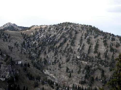 This nondescript ridge point is the sixth highest in the range.
 The summit
 Summit register
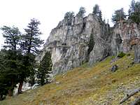
 The north cliffs
 East ridge
At 9,736, this unnamed mountain is the sixth highest summit in the Bear River Range, a local chain of mountains that runs from extreme northeast Utah into southeast Idaho, between Bear Lake and Cache Valley. Though it is one of the highest summits in the range, it is formed by a fairly non-descript ridge point. Indeed many may question the appropriateness of this seemingly insignificant ridge point having its own summitpost page. Though it’s not the least bit sexy compared to some of the other summits in the area the mountain is here considered worthy for a number of reasons. Besides being the sixth highest point in this significant range, it is the highest point along the main crest between Doubletop Mountain and Bullen Hole Peak; a ridge line distance of nearly four miles. It also has 357 feet of prominence.
This mountain is situated just off the east crest of the main divide on the long ridge separating the White Pine and Steam Mill basins about one and a half miles north of Bullen Hole and just over two miles south of Doubletop Mountain. It is separated from the more rugged, but slightly shorter Mount Gog, by the broad basin forming the head of the north fork of White Pine Creek. The main ridges to the north and south are quite gentle and rounded, though the slopes falling off them are quite steep. The same is generally true of the east ridge except for the north face of the high point, which is formed of very precipitous cliffs that rise approximately 900 feet above the broad subalpine basin below. On the south side the basin is about 1,500 feet below. The bottom of High Creek to the west is over 3,000 feet below the ridge in deeply incised canyons.
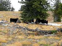
The mountain is composed of dolomite over quartzite formed from ancient tidal mud and coastal beaches. There are a handful of small caves in the area and occasional fossils can be found. The upper subalpine slopes are near the climatic timberline for the area and support open forests of limber pine, whitebark pine, subalpine fir and spruce, with occasional Douglas fir. The area is included in the Naomi Peak Wilderness, which unfortunately can be overrun with cows part of the year. In the fall, the trailhead areas are heavily hunted so wear orange. There is a summit register located under some large rocks just west of the high point. There are several entries from the mid-1990s, but very few recent ones. This would be expected as it’s easy to not notice this mountain when viewing all the others around. It’s not a common destination.
There is some discrepancy concerning an unofficial name for this mountain. Some call it Steam Mill Peak for the lake and basin it rises above. Others give that name to a lower point to the east. SP member D-bo reports that a locally written guide book gives it the name Pika Peak, which is the name applied here.
Getting There
 The summit from the southwest saddle.
 Steam Mill Basin
 South ridge
 Nearing the summit
The easiest routes to this summit start at Tony Grove Lake. To reach the trailhead at Tony Grove from Logan, Utah, head east up Logan Canyon. The directions start on main street in Logan, then turn east on 400 North. Follow the signs for Logan Canyon, Bear Lake and Highway 89. 400 North becomes Highway 89 and gives a beautiful drive up the twisting, narrow Logan Canyon. After driving for about 19 miles look for the turn off to Tony Grove, which is well signed. Take the turn and proceed seven miles to the end of the road and trailhead at Tony Grove Lake. From this trailhead, there are a number of ways to reach the mountain.
From the south
From the Tony Grove trailhead hike towards White Pine Lake but before reaching the lake continue north at the east base of Mount Gog into the basin between Gog and Peak 9,736. Maps show a trail ascending this basin, but it is spotty in the upper elevations and it may be best to head straight up the broad slope or climb to the ridge at the head of the basin, then loop to the north and east to the high point.
Other routes would include hiking to White Pine Lake and crossing the saddle between Mount Gog and Bullen Hole Peak to enter the basin between Gog and Peak 9,736. Or get on the main divide west of this same saddle or get on the divide from Naomi Peak, which is also accessed from the Tony Grove trailhead. For more information on the routes from Naomi, over Bullen Hole refer to the Bullen Hole page. From Bullen Hole it’s an easy hike north on the main divide to this summit.
From the east
To reach this area from the east drive up Logan Canyon for about 25 miles and take the Franklin Basin road to the west. After about a quarter mile, the Steam Mill Canyon trailhead is on the west side of the road. It’s about four mile to the head of Steam Mill Canyon, then a short hike south on the main ridge to the short spur ridge to the east where this high point is found. The mountain can also be easily hiked from Doubletop Mountain via the Steep Hollow route. Refer to the Doubletop Mountain page for this access information.
Red Tape
 Local residents
Standard wilderness regulations apply.
There is also a $5 fee to park at the Tony Grove trailhead during summer months.
Camping
 The basin between the mountain and Gog provide good camping.
 Tony Grove Lake
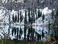 White Pine Lake
There are several excellent camping opportunities in the vicinity of this mountain. For those wishing to camp out of a car, there is Tony Grove Campground at Tony Grove Lake near the trailhead. This is a large campground, but it can fill up frequently in the summer so reservations may be advisable. There is no drinking water, but toilets are available. The campground is situated on a nice lake with a nature trail and several opportunities for day hikes of any length or difficulty.
Backpackers can find good camping at White Pine Lake or High Lake. White Pine Lake can get crowded and this is being managed by signs indicating designated camping and non-camping areas near the lake. High Lake isn’t real close to the mountain, but is still an easy day hike. The basin above White Pine Lake or the basins north or west of Mount Gog offer more remote and isolated camping opportunities and both are closer to the mountain. There are several streams and springs that offer water in most of these areas except perhaps late in the drier summers when water may be limited to lakes and the main streams. Steam Mill Lake on the north side of the summit ridge and the empty basin directly below the high point also provide good back country camping. The north side of the ridge is much more rugged so getting onto the summit from that side requires ascending the head of the basin to the west and then hiking south, then east to the high point. It is probably possible to scramble up from the lake, but this would require more planning.
 Mount Magog rising over White Pine Lake.
When To Climb
 South basin
The summer is the best time to climb this mountain. Winter access is possible, but would require a long approach on snowshoes. Hiking is possible late in the fall until the first heavy snows, generally in late October or early November. If hiking this time of year pay attention to the weather forecasts and remember that the days are short.
Mountain Conditions and Information
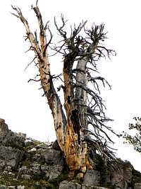 Limber Pine snag
During the summer weather is generally good in these mountains, but always watch the weather forecasts and be aware that summer afternoon storms frequently can blow up with little warning. Nights can be very cold despite the days being quite warm. Always when entering high mountains be prepared for a wide array of warm or cold conditions.
The mountain is located on the Logan Ranger District within the Wasatch-Cache National Forest.
Logan Ranger District
1500 East Highway 89
Logan, UT 84321
(435) 755-3620
NOAA Forecast