

-
 6616 Hits
-
 84.27% Score
-
 18 Votes
|
|
Mountain/Rock |
|---|---|
|
|
42.10586°N / 111.66203°W |
|
|
Franklin |
|
|
Hiking |
|
|
Spring, Summer, Fall, Winter |
|
|
7682 ft / 2341 m |
|
|
Overview
Although not one of the major peaks in the Bear River Range, Sugar Creek Mountain makes a wonderful early season hike or an easily accessed excursion near Preston, ID. Since it is located at a lower elevation in the foothills of the range it melts out much earlier than the high country. The peak can be climbed any time of the year and would make an excellent snowshoe destination in the winter but the approach would be much longer.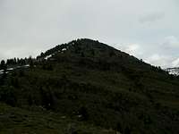 The Highest Point
Although the mountain is unnamed, Sugar Creek Mountain would be an appropriate name since it sits on the North side of Sugar Creek, separating it from Litz Basin. This area rugged area of the western Bear River Range is located completely in Idaho but is only a few miles north of the Utah border. It is also part of the Mt. Naomi Roadless Area
 Bear River Front
This peak has three summits, the highest of which is at an elevation of 7,682 ft. Although this is a class 2 hike there are a number of places where some easy class 3 scrambling can be done. A rocky ridge with a number of cliff bands sits just below the lowest summit and although it can be avoided altogether, going over it makes the hike a little more interesting.
 Class 3 fun
The approach is short being only about 2.5 miles, about half of which is on a trail.
Interesting Features
A lot of wildlife frequents this area including moose. In fact it is quite probable that you may see one in the area. Wild Turkeys, Deer, and Elk are also quite common.
Another interesting feature is the rock river in Spring Hollow between the two lower summits. Here a stream of water flows beneath a rock field, invisible but very audible. Here is a link to a short video I made so that you can hear it.
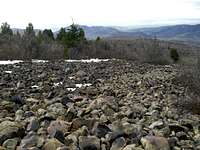 Rock River
Getting There
 Trail
Trail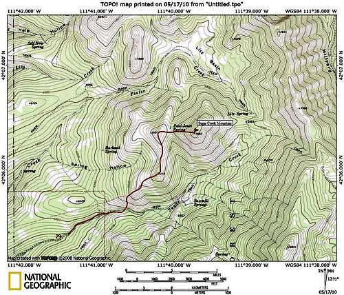 Map
MapRed Tape
The area is popular with ATV riders so be on the lookout while on the trail. Once you're off the trail you'll probably have the whole mountain to yourself.There is also one major crossing of Sugar Creek along the trail which can be tricky in the spring when the water is high.
 Andrew Nyman Mountain
Weather

 Bad Weather
Camping
There are plenty of wonderful camping spots available in Sugar Creek near plentiful water. The major drawback is the noisy ATV's that muddy up the trail in the spring and make things dusty in the Summer and Fall. Higher up on the mountain there are many beautiful and quiet places to camp that are out of the ATV area.As always PLEASE practice Leave No Trace principles. There are many others who haven't done so in this area and it needs some TLC.
The area is in the Cache National Forest but is administered by the Montpelier District of the Caribou National Forest.
 Evening Light
External Links
Caribou-Targhee National ForestRalph Maughn's Idaho Wildlands Page.
 Sugar Creek