
-
 11332 Hits
-
 89.12% Score
-
 29 Votes
|
|
Mountain/Rock |
|---|---|
|
|
41.90172°N / 111.66983°W |
|
|
Cache |
|
|
Hiking, Scrambling, Skiing |
|
|
Spring, Summer, Fall, Winter |
|
|
9700 ft / 2957 m |
|
|
Overview

Castle Rock
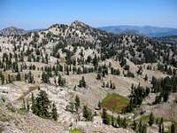
Castle Rock Peak is situated in one of the most visited areas in the Bear River Range. Despite its location, the mountain doesn't seem to draw much attention. This is due to a number of reasons. The obvious being its proximity to Naomi Peak, the highest peak in the range, which is where most people go. Unlike its neighbor, there is no trail to the top. Castle Rock Peak lacks prominence and the summit isn't visible from Tony Grove Lake. Large cliffs block a complete view of the mountain so it blends in with the surrounding area.
This mountain isn't officially named but known locally as Castle Rock Peak especially by skiers. Avalanches can sometimes be spotted on its steep east face during winter. It received this name because of a rock formation called Castle Rock near the main ridgeline. From the summit is a unique view of the south face of Naomi Peak. You can also see Mount Magog and Mount Gog to the north, Mount Elmer and Mount Jardine to the south, and Cache Valley to the west. On the east side of the peak is a dry lake basin, but I suspect you'll find some water during springtime.
Castle Rock Peak is approached from Tony Grove. The area sits at the end of a side road from Logan Canyon. This is also where Tony Grove Lake is located. Tony is an informal term meaning, "fashionable among wealthy or stylish people." The name derives from its popularity with wealthy residents of the Logan and Cache Valley area in the late 19th and early 20th centuries. Some of those affluent families would spend several weeks staying there and socializing within the grove of lush green trees. Nowadays, you will see all types of people recreating here, notably on summer weekends.
The Bear River Mountains form the northern extension of the Wasatch Range. These mountains start in southeast Idaho and continue across the border into Utah. With the exception of a few trails such as the Wind Cave, Jardine Juniper and Naomi Peak, you probably won't see too many people. This is a great area with many mountains and lakes. Numerous peaks reach above 9,000 feet in elevation. They vary from rolling hills to summits surrounding by limestone cliffs. Most mountains only require some off-trail hiking and scrambling but more difficult routes can also be found. Some of the most interesting peaks are unnamed.
Getting There
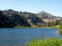
Tony Grove Lake
In Northern Utah, drive on I-15 north of Brigham City and take exit 362 (US-91/Logan). Keep driving on US-91 through Sardine Canyon. After 25 miles US-91 will merge into Main Street in Logan. Drive to the intersection of Main Street and 400 North in Logan. Turn east on Highway 89 into Logan Canyon. Drive for about 18 miles to the exit to Tony Grove. Turn here and follow this road for 7 miles to the trailhead and parking lot for Tony Grove Lake.
If coming from the northeast near the cities of Soda Springs or Montpelier in Idaho. Turn onto Highway 89 and drive south toward Garden City which is on the east side of the range near Bear Lake. Drive up the switchbacks into Logan Canyon. Go over the summit of the canyon and then drive to the road junction with a signed turnoff to Tony Grove. Drive up this road for 7 miles to the trailhead parking lot.
Route Information
Castle Rock Traverse

Castle Rock Peak
This route climbs up to Castle Rock Peak and several other points along the ridge. I did this as a loop starting from Tony Grove. This was hiked in a counter-clockwise direction but it can be down either way. You can also combine Castle Rock Peak with Naomi Peak together. There is a steep descent following the ridge going south from Naomi Peak. There is some scrambling involved on the main ridgeline. You can avoid it and stay on the west side of the ridge to keep it at class 2 the whole way. This is a good peak for those of you who want to bypass the crowds on Naomi Peak. This peak offers great views of Cache Valley and the high peaks in the range. This loop hike is 7 miles with 2,000 feet elevation gain.
Other Options:
1) A direct route starting from the west side of Tony Grove Lake can be done. The hardest part is navigating the steep cliffs right above the lake. I haven't done this route but met another hiker that had. This would be the shortest route to the top though.
2) Another route would follow the Naomi Peak trail. Then leave the trail and traverse into the dry lake basin located near 8976 feet elevation. There is a steep hike up toward Castle Rock formation where you can hike onto the ridge and traverse to the summit from there.
3) The last route would be to start the hike from the south end of Tony Grove Lake. Then you can find a climber’s trail leading to the saddle between Point 8942 and Point 9248. From here you can follow the ridgeline west and then north to Castle Rock Peak.
Camping

Castle Rock Peak
The best place to camp is at Tony Grove Lake. At higher elevations near the ridgeline, I saw a few fire rings used by backpackers. Backcountry camping is allowed in undeveloped sites as long as you follow rules. You must be 200 feet away from any road, trail, or water source. The camping limit in one spot is 16 days. Practice leave no trace techniques.
There are several campgrounds located along the Logan Canyon Scenic Byway. Some of them are first come, first serve and others can be reserved online. The campgrounds are usually open from Memorial Day to mid-October. Tent camping will cost between $17 to $20 a night.
Spring Hollow Campground is located 4 miles up the west side Logan Canyon. It is near the Logan River and Spring Hollow Creek. There are 12 sites available. Guinavah Campground is 5 miles up the west side of Logan Canyon. It is located in the forest near the Logan River. There are three loops that have a total of 40 sites. Tony Grove Campground is about 18 miles up Logan Canyon at an elevation of 8,100 feet. The campground has 37 sites. Sunrise Campground is located 6 miles west of Bear Lake and 1 mile east of Bear Lake summit. It sits at an elevation of 7,800 feet. There are 27 sites available here.
Lower Logan Canyon Campground Reservations: Spring Hollow Campground and Guinavah Campground
Upper Logan Canyon Campground Reservations: Tony Grove Campground and Sunrise Campground
When to Climb
Mount Magog

Naomi Peak
The main hiking season for this peak is from June through October.
Castle Rock Peak can also be hiked in late spring and early fall depending on snow conditions. In normal years, snow last into early summer. People who have climbed nearby Naomi Peak in June or early July usually see some snow at the higher elevations so expect similar conditions on this peak. In fall, there are fewer people out hiking. Hunting season is in September and October so bright clothing is recommended.
Tony Grove can be accessed in winter by snowmobiling, skiing or snowshoeing. This will add 14 miles round trip to the total mileage.
Red Tape

South Ridge

North Ridge
$6.00 parking fee at Tony Grove Trailhead.
It should also be noted that you can park down lower in the campground. If you have an America The Beautiful Pass then it is free to park here. This just adds a small amount of walking distance.
Castle Rock Peak is located in Wasatch-Cache National Forest.
Logan Canyon has a paved road that any vehicle can drive through. It is plowed in winter but the road to Tony Grove is not. Snowmobilers will usually pack down the road to the trailhead unless it has snowed recently.
| Logan Ranger District | Wasatch-Cache Main Headquarters |
| 1500 East Highway 89 | 857 West South Jordan Parkway |
| Logan, Utah 84321 | South Jordan, Utah 84095 |
| Phone: (435) 755-3620 | Phone: (801) 999-2103 |
External Links
You won't find information about this peak in books. If accessing Castle Rock Peak in winter, check snow conditions before you go.Logan, Utah Avalanche Center
This has advisories, weather, and information on avalanche conditions in the mountains above Logan.