
-
 48061 Hits
-
 91.45% Score
-
 35 Votes
|
|
Route |
|---|---|
|
|
41.01930°N / 122.975°W |
|
|
Hiking, Scrambling |
|
|
Summer, Fall |
|
|
Overview
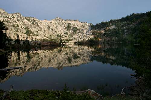
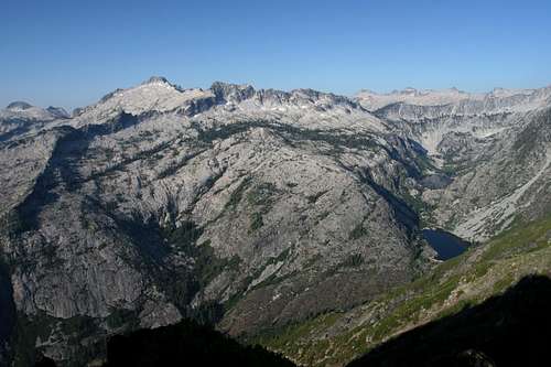
Caribou Lake, destination of the Caribou Lakes Trail
The trip to the Caribou Lakes is one of the classic backpacking trips in the Trinity Alps. In addition to visiting Caribou Basin, the trek also offers a stop at Little Caribou Lake and a chance to climb to the top of Caribou Mountain itself. Two trails, the Old and New Caribou Trails actually lead to Caribou Basin. The Old Trail is routed along the Salmon River and then climbs straight up and over Caribou Mountain, topping at 8,118 feet, only 450 feet below the summit. From this point it descends 1,200 feet down into the basin. The New Caribou Trail was constructed in the 1950’s and is routed around the side of Caribou Mountain, resulting in a much more reasonable grade. While it is possible to climb up the Old Trail to the top of Caribou Mountain as a day trip, it is a much more pleasurable experience to take the New Trail to Caribou Basin and camp at one of the lakes. From there, one can make a much easier (1,600 fewer feet to climb) day trip up to the summit or one can take the Old Trail back to the trailhead, thus completing a great figure-eight and climbing the peak as a short side-trip. If one has the time, this is the preferred option and this page will follow this course.
From the trailhead to Caribou Lake via the New Trail is almost 9 miles.
From Caribou Lake to the trailhead via the Old Trail is nearly 7 miles.
Route Description
The New Caribou Trail begins at the Big Flat trailhead, on the east side of the Salmon River. The elevation at the trailhead is 5,041. The trail immediately drops down to the river, which must be forded. Once across the river, the trail splits. The Old Trail heads downstream to the right. Continue straight on the New Trail, up the west bank of the river. From here the trail begins to switchback at a moderate grade up the side of Caribou Mountain. After 0.5 miles, the trail begins a long southward traverse, extending for a mile before switchbacking to the north. Views to the southeast are good. Preacher Peak, Black Mountain and Red Rock Mountain are all visible on the east side of the Salmon River Canyon. Another 0.5 miles later, the trail switchbacks again to the south. After climbing a final 0.6 miles, the route finally reaches a saddle at 6,300 feet. Here, at Caribou Meadows, the New Trail intersects the Old Trail, which is completing its long descent of one of Caribou Mountain’s massive ribs. From here the Old Trail begins its trek down Caribou Gulch to the Salmon River. More on this will be discussed later. Caribou Meadows is a nice grassy spot, but is not much compared to impending Brown’s Meadows or the lush terrain on the east side of Caribou Lake.
Browns Meadow
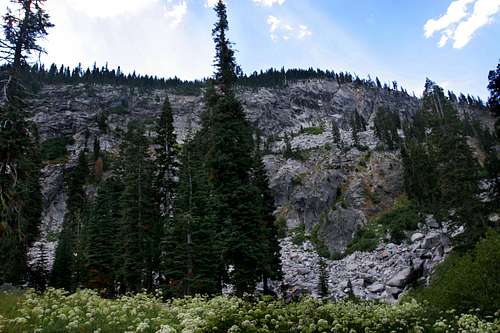
From Caribou Meadow, the New Trail begins a long traverse to the west, toward Point 6,708. The route is carved right into the granite cliff, the first such encounter with this rock type thus far. Point 6,708 and the area below it burned in 2008 and a ghost forest of snags presents an eerie sight as one rounds the small peak. Once around Point 6,708, the New Trail passes into Browns Meadow, the only reliable source of water on the trail. The meadow runs up against sheer granite walls to the south. The grassy area yields a fine creek that is choked with alder trees. The point where the trail crosses the creek is the best place to get water. If one intends to camp before reaching the lakes, this is the only realistic option.
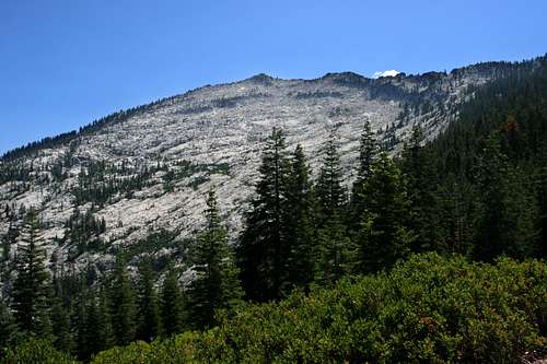
Caesar and Thompson Peaks from the New Trail
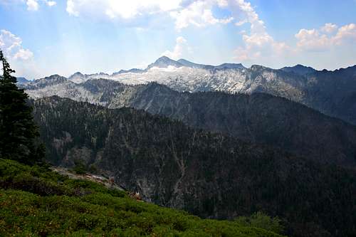
From Browns Meadow, the trail begins to switchback moderately. After climbing four hundred feet the path reaches a saddle and the majestic core of the Trinity Alps comes into view for the first time. Caesar Peak is front and center, with Thompson Peak, the highest point in the Trinity Alps peering out from behind. The sound of Caribou Creek crashing down the canyon below Lower Caribou Lake is audible for the first time. From the saddle above Browns Meadow, the trail begins a long traverse to the south, round the shoulder of Caribou Mountain. The route is increasingly slung precariously on the side of the mountain. Some vertical switchbacks facilitate getting around some sheer stretches of cliff. Views of Caribou Basin continue to improve. After 1.4 miles from the saddle above Browns Meadow, the New and Old Trails converge in a dense stand of fir trees. From this point, the trail begins a switchbacking decent down to Snowslide Lake, the first of the three lakes in the basin.
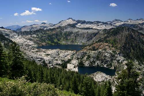
Snowslide Lake
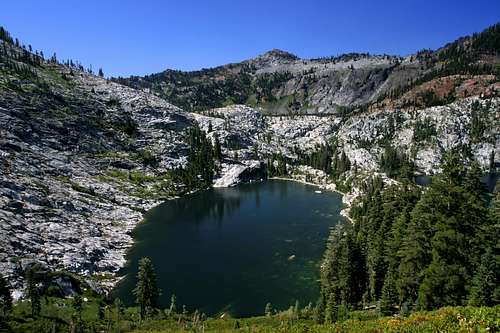
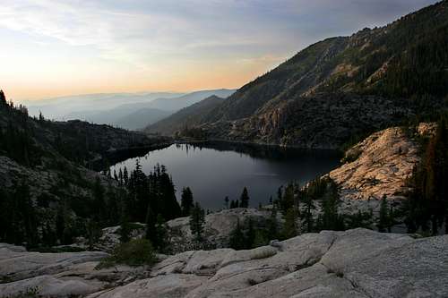
A small meadow indicates the arrival at Snowslide Lake, at 10 acres, one of the larger lakes in the Trinity Alps, though not much more than an after thought to what lies ahead. Nonetheless, the lake is spectacular in its own right. To the east, granite cliffs soar 2,000 feet to the summit of Caribou Mountain. On the west side of the lake is a granite dike that separates Snowslide from Lower Caribou, which at 30 acres, is one of the larger bodies of water in the Trinity Alps. It is in a massive granite bowl with sheer walls rising a hundred feet out of the water. A small pool occupies the south end of the dike between the two lakes. This is sometimes referred to as Middle Caribou Lake. The campsite on the west side is one of the finest in the area.
Sawtooth Peak and Emerald and Sapphire Lakes from Sawtooth Ridge above Caribou Lake
From Snowslide Lake, the trail crosses the granite dike and then climbs up to a ledge on the south side of the lake. The route arcs along the ledge, through small, lush meadows and bright, white granite. After passing several small tarns, the trail finally reaches astounding Caribou Lake. At 72 acres, it is the superlative lake in Northern California. Sheer walls climb high above the lake on three sides. To the north, Lower Caribou Lake is visible, with the northern Trinity Alps and Marble Mountains discernible in the distance. The trail, now in much poorer condition continues around the east side of the lake, passing through extensive meadows and boulder fields before beginning to climb the basin headwall. This steep trail rises swiftly up cliff until reaching the top. Looking south, Sawtooth Ridge tears at the sky while the Stuart Fork of the Trinity River lies 2,500 feet below. To the west, Sawtooth Peak, Caesar Peak and Emerald and Sapphire Lakes can be seen. The Caribou Scramble, a steep route down to the Stuart Fork plummets the entire 2,500 feet in 1.5 miles. If at all possible, avoid attempting this trail in the heat of the day. People have died from exposure while climbing it.
Old Caribou Trail Pt. I
Caribou Lakes and Sawtooth Peak from Caribou Mountain
To return to Big Flat and to summit Caribou Mountain, the Old Trail makes an attractive choice for a return trip. Be forewarned, the trail is relentlessly steep in climbing out of Caribou Basin and it is punishingly steep in its decent down to the Salmon River. Nontheless, the views, the opportunity to climb the mountain and the chance to visit Little Caribou Lake make the trip worthwhile.
Returning to Snowslide Lake, begin climbing out of the basin on the trail one arrived on. At the junction with the Old Trail, begin climbing in earnest. The trail will switchback continuously through the trees, climbing 1,200 feet in a mile. There are minimal views, but plenty of shade until the final 0.1 of a mile when the trees fall away and incredible views of the Caribou Basin and the granite heart of the Trinity Alps, particularly Sawtooth and Caesar Peaks become available. This vista is one of the finest in the Trinity Alps. A few more swithbacks after the views open up, the trail tops out at Point 8,113.
Climbing Caribou Mountain
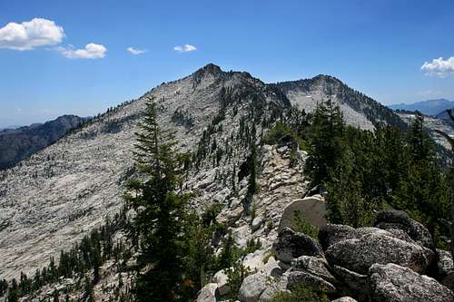
Ridge route to summit of Caribou Mountain
Those wishing to climb the mountain should do so from this point. There are two options to get to the summit. The best, and most direct is to simply strike out south along the ridge from Point 8,113. The optimal course here is to stay just below the top of the ridge, which is generally a knife-edge with a sheer drop on the west side. This route is the easiest and most direct way to the top of Caribou Mountain. The biggest draw back to it is the two points of exposure that are encountered. The first is a long cliff band that is quite a bit below the top of the ridge. For the most part, if one sticks close to the ridgeline, than it is difficult to even perceive the cliffs below. However, there are a few points when the distance between the cliffs and the ridgeline narrow and the exposure is more apparent. In spite of this, there is still significant distance between the cliff and the top of the ridge. The second point of exposure is another small set of cliffs near the summit. For those who wish to bypass the exposure, the choice means dropping down below the cliffs, skirting their base, then climbing back up to the ridge and following it the top. The only positive that recommends this route is the small, nameless tarn located below the cliffs, which is worthwhile only to those who seek to visit every mountain lake in the world.
Old Caribou Trail Pt. II
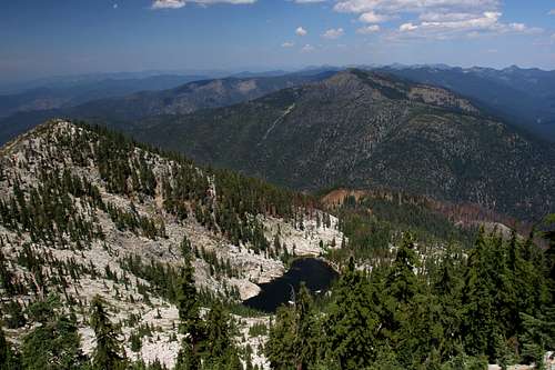
Little Caribou Lake
Having reached Point 8,113 from Caribou Basin or on the return from the top of Caribou Mountain, the route back means a swift, remorseless drop down to Caribou Meadow, first passed on the New Trail. A seemingly endless number of switchback is the order of the day. After about 1.0 miles, the trail begins to traverse to the east. It is at this point one should strike off to the west, maintaining a level course, to reach Little Caribou Lake. Beyond the aforementioned traverse, the trail switchbacks a few more times before leveling off on a ridgeline. The granite cliffs around Point 6,708 and the New Trial are visible from this point. Large parts of the ridge are colored pink and red, the slowly disappearing fire retardant dropped to create a firebreak during the summer of 2008. Below the ridge the trail switchbacks a few more times before arriving at Caribou Meadows, where it intersects the New Trail.
Caribou Mountain from the Old Trail
If one wants to return on the New Trail, creating a lollipop rather than a figure-eight, the route will be two miles longer, but nearly as steep a decent as the Old Trail. For those intent on completing the Old Trail (which is recommended) then continue north of Caribou Meadows, dropping immediately into Caribou Gulch. The path instantly crosses to the west side of the gulch, where it continues down another endless seeming succession of switchbacks. Keep an eye out for old mattress springs, metal relics and an unusual ditch that seems out of place. This is an old flume and cabin site from the 19th century Caribou Mine. Once the trail crosses over the creek, this is an indication that the grade will level out and a final, long traverse of the lower flanks of Caribou Mountain is commencing. As one rounds the shoulder of the mountain and begins to head easterly, the roar of a waterfall on the Salmon River below becomes louder. Though not visible from the here, it is a sign that the trail has just about reached the canyon bottom. Once on level ground, the route parallels the Salmon River for almost 0.5 miles before meeting up again with the New Trail. Ford the river and climb up to the trailhead.
Caribou Lakes Trail Map

Getting There
Lower Caribou Lake
From Highway 299 in downtown Weaverville, drive north on Highway 3. After 37 miles, turn left onto Coffee Creek Road. Proceed through the small community and continue for 18 miles to the Big Flat Campground. The road is dirt once you pass through Coffee Creek, but it is suitable for low clearance vehicles. Cars should, nonetheless, exercise caution. The trailhead is near the entrance to the campground. If coming from Oregon, exit Interstate 5 at the junction with Highway 3 in Yreka and continue south to Coffee Creek.