
-
 23541 Hits
-
 78.27% Score
-
 9 Votes
|
|
Route |
|---|---|
|
|
41.13254°N / 122.76917°W |
|
|
Hiking, Scrambling |
|
|
Summer, Fall |
|
|
Overview
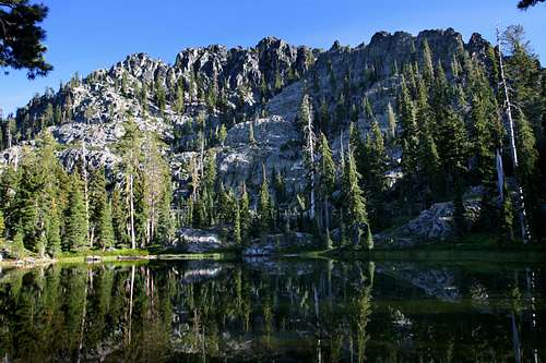
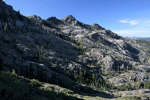
The north shoulder of Billys Peak from Upper Stoddard Lake
The Stoddard Lake Trail offers many of the best aspect of the Trinity Alps in a tight, cohesive package. A relatively easy trail accesses a broad basin containing three lakes. En route, one passes through a spring filled meadow and glimpses of high peaks abound. The lakes themselves offer beautiful views, great fishing and cool swimming.
Camping around the lakes is excellent. However, in spite of all of these excellent attributes, the Stoddard Lake Trail only offers a piece of a larger puzzle. Beyond the end of the trail a fantastic scrambling route leads to the summit of Billys Peak and beautiful Holland Lake, one of the most obscure and attractive lakes in the Trinity Alps. Whether looking for an easy hike to a large lake or on the hunt of obscure tarns and summits, the Stoddard Lake Trail is the gateway to an excellent corner of the Trinity Alps.
Route Description
The Stoddard Lake Trail passes throu the headwaters of East Fork Coffee Creek, on the far right
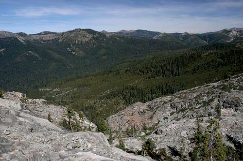
The Stoddard Lake Trail departs the trailhead at a moderate grade, climbing towards a saddle to the west. The ascent is constant, never really leveling off as it passes through a mixed forest of pin and fir. Occasional views of the granite ramparts of the Bear Lake Basin break through the trees. This part of the trail is slung high up on the walls of the canyon through which Eagle Creek flows. Eagle Creek begins below Eagle Peak, one of the high peaks of the Scott Mountains.
After a mile the trail begins to traverse a broad cirque. Springs water a moderately large meadow filled with Darlingtonia, a carnivorous plant found throughout the Klamath Mountains. The trail continues to climb through the meadow, especially as one nears the far end of the arc. After a little over 1.5 miles from the trailhead, the trail finally reaches the pass separating the Eagle Creek watershed from the East Fork of Coffee Creek. The pass is heavily wooded and devoid of views, giving little cause to pause.
From the Eagle Creek – East Fork Coffee Creek Pass, the Stoddard Lake Trail begins to descend immediately. Shortly after leaving the pass, the trail enters Stoddard Meadow. The meadow is not an expansive grassy plain like many of the others in the Trinity Alps. Instead, it consists of several grassy parks broken up by bands of forest. While Stoddard Meadow is quite large, its disrupted nature tends to understate how much area is actually covered.
The ruins of Stoddard Cabin are found in the meadow. The Stoddard name comes from a prominent 19th century rancher who lived in the area. About 0.5 miles after the pass, the trail crosses a small creek. Shortly after the creek the trail finally reaches a junction. Staying to the right leads to the East Fork Coffee Creek Trail. To get to Stoddard Lake and Billys Peak, veer left.
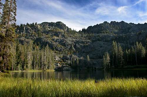
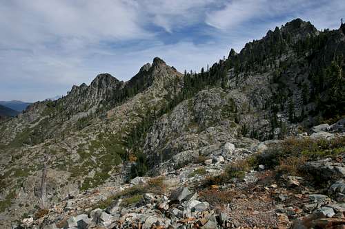
The north shoulder of Billys Peak from McDonald Lake
Beyond the junction, the trail remains in tree cover for almost exactly 1 mile, climbing steadily but gradually. At the conclusion of the mile, the trail deposits one on the shores of large Stoddard Lake. At 25 acres, it is one of the biggest bodies of water in the Trinities. Unlike other lakes in the range, it is entirely tree-ringed, more reminiscent of lakes in southern Oregon, particularly the Sky Lakes Wilderness. Thankfully the trees do not obscure the granite shoulder of Billys Peak lying just beyond. It is a beautiful spot to take a break.
Once at the lake, the trail splits. To the left is a route that circumambulates the lake. Splitting off this lake to the east is an extremely faint route that leads back to the trailhead. This leaves open the possibility of creating a bit of a loop on the return. A word of caution however, as the route is extremely faint and overgrown.
To continue on to McDonald Lake, stay to the right at the junction, continuing around the west side of Stoddard Lake. On the southwest corner the trail passes through a small meadow. When the trail reenters the woods, this is the point from which to veer off to the west in order to climb Billys Peak. To continue on to McDonald Lake, remain on the trail until it deposits one at the lakes outlet. McDonald Lake is a smaller, more intimate version of Stoddard Lake. Although trees line much of the shore, the south end of the lake is a barren rock wall rising 1,000 feet out of the water to the tops of some of the spires that line the ridge leading to the summit of Billys Peak. This is a worthy destination in its own right.
Climbing Billys Peak
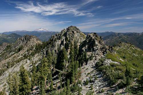
Mount Shasta barely visible beyond Upper Stoddard Lake
The real adventure of climbing Billys Peak begins when one leaves the Stoddard Lake trail midway between Stoddard and McDonald Lakes. High above the two lakes is diminutive Upper Stoddard Lake. Getting to this lake can be a bit of a challenge, depending on how one goes about it. It is possible to climb directly up to the lake from the south end of McDonald Lake. This route involves significant boulder scrambling and bushwhacking up a 450 foot cliff. While this is certainly manageable, there is an easier way.
To take this path, head southwest off trail through the woods from the Stoddard Lake Trail shortly after it reenters the woods from the meadow on the south side of Stoddard Lake. Although it climbs, the route does not have much of a grade. It is important to maintain a southerly orientation as one hikes to the east. If the trajectory is accurate, the passage through the woods should only last a few hundred yards before it opens up on a treeless slope through which flows an often-dry creek.
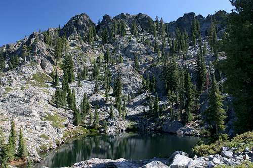
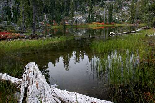
An extremely faint use trail winds its way up the slope to the west before turning south near the top of the clearing. The trail can be followed all the way to the edge of Upper Stoddard Lake, perhaps the prettiest of the three bodies of water in Stoddard Basin. The ramparts of the Bear Lake Basin line the northern horizon and to the east Mount Shasta is visible. The granite spires of Billys Peak loom directly overhead.
Billys Peak seen from above Upper Stoddard Lake
To continue on to Billys Peak climb the brushy slope directly behind Upper Stoddard Lake. Once on top of the slope, the grand spectacle of Billys Peak becomes manifest for the first time. A 2,000 foot wall of granite extends westward for nearly two miles. This is the first opportunity to observe the summit of Billys Peak, which is obscured from nearly every other vantage.
This is a good opportunity to pause and observe the route to the summit, since most of it is visible from this perspective. Most of the route maintains a level traverse along the flank of the mountain, just below the spires leading to the summit.
Immediately above the shoulder separating Upper Stoddard Lake and Billys Peak there is a mass of dark rock. The route skirts the bottom of this jumble before climbing up the scree slope on its south side. After climbing 50 yards or so up the slope, turn right, continuing a lateral traverse through any available clearing in the brush lining the scree. It is necessary to navigate around several brushy patches for about 0.1 miles before the route reaches another open scree field.
Continue the lateral traverse along the loose rock, much of which is still seeking an angle of repose. Beyond this, it is necessary to scramble 30 feet or so up a small cliff. Once atop the cliff, the route follows a level bench for about 0.25 miles. This is the easiest part of the off trail route. The views to the north are interesting and the summit of Billys Peak continues to grow larger as one advances.
Looking at the route from Upper Stoddard Lake to Billys Basin
At the west end of the bench, there is a deep gully that must be crossed. Before crossing, observe the summit of Billys Peak. Below it, one can make out tall band of cliffs several hundred feet below the top of the mountain. Below these cliffs there is a small bowl which, though obscured by more rocks should be apparent. This is the next destination.
On the far side of the gully, the cliffs are fairly steep with no route seeming to be the best. Angle towards the bowl, crossing the brushy slopes on the far side of the gully. It is possible to climb over the brushy areas but the brush is smaller than it looks and provides good footing on these steep cliffs. On the far side of this steep section there is a beautiful little bowl filled with a set of small tarns and meadows. They last well into September and October. Though unnamed, this valley will be referred to as Billys Basin for the sake of convenience.
To proceed to the summit of Billys Peak, depart Billys Basin to the west, following along the base of the cliffs overhead. An obvious ramp climbs out of the basin by this route, passing one more tarn along the way. After 0.15 miles, the ramp turns sharply to the left, climbing to the backside of the cliffs that lined the Billys Basin. Here one must traverse the top of a narrow fin of rock to reach the broad bench that sits between the basin and the summit of Billys Peak. If one desires to reach Holland Lake, this is where the route to that lake deviates from the route to the top of the mountain.
Mount Shasta from the summit of Billys Peak
Billys Peak Summit
The route to the summit of Billys Peak is straight forward from this point on the bench above Billys Basin. Immediately to the south is a narrow talus slope that leads between the summit and one of the numerous large spires that line the crest of the ridge leading back to Stoddard Basin. Climb to the crest.
At this point the views really open up, with Mount Shasta and Mount Eddy being the most dominant landmarks. The most eye-catching however is the stunning spike that is Billys Peak Lookout. From every other vantage, this amazing peak fails to make a lasting impression compared to this magnificent view. This is because the north side of the mountain, consisting of a pyramid shaped 1,500 foot granite cliff is obscured from every other possible vantage.
The full grandeur of this mountain is reserved only for those who make the ascent of Billys Peak. To reach the summit from the top of the talus slope, continue to the west. Unfortunately the route consists of 100 yards of the worst brush fight yet encountered on the route. The climb up the summit block consists of a Class IV climb.
Holland Lake
Holland Lake
Small Holland Lake is one of the least known yet most beautiful lakes in the Trinity Alps. It is easy to tie a detour to the lake in with a trip up Billys Peak. To reach the lake from the bench above Billys Basin, simply head west, climbing over large boulders as one proceeds. The route is about 0.25 miles and fairly straight forward. There is a large shoulder of rock that must be climbed before the lake is evident. From there it is a simple matter of climbing down to the lake.
The lake is small but surprisingly deep. It looks to be at least 30 feet deep. Granite cliffs soar directly out of the lake, climbing 550 feet out of the lake to the summit of Billys Peak. Mount Shasta and Mount Eddy are visible to the east, just left of the tall spires that make up the crest of Billys Peak. Surprisingly there is a small campsite (there is room for only one site in the rocky basin around the lake). The site has magnificent views and hosts what must be one of the remotest geocaches around. Despite the majesty of the surroundings the evidence of prior visitation, solitude is guaranteed. Few know of this spot.
Stoddard Lake Trail Map
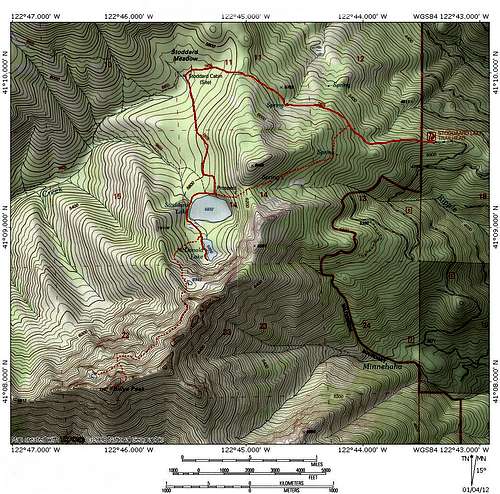 Stoddard Lake Trail and route up Billys Peak
Getting There
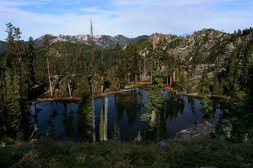
Fall colors at Upper Stoddard Lake
From Weaverville, travel north on Highway 3 for 43 miles. Turn left on County Road 135, signed for Horse Flat - Eagle Creek. Continue 1.5 miles, turn left onto unpaved Forest Road 38N22. There is usually a sign indicated that the road heads to the Stoddard Lake Trailhead. The road is pretty easy to follow, with the best conditioned road the route to follow at any forks (this sounds imprecise, but the route really is self evident). Just shy of 6 miles the road comes to a junction. Stay left, going onto Forest Road 38N27. Another 2.5 miles brings one to the trailhead, at total of 8.5 miles after having turned off County Road 135.
From Mount Shasta City, drive north on Interstate 5, through the town of Weed. Exit at the Edgewood/Stewart Springs exit. Turn left and drive under the freeway, then turn right onto Old Stage/ Old 99. Continue north for a couple hundred yards and then turn left onto Stewart Springs Road. After 4 miles, Forest Service Road 17 splits off to the right. Follow this road for 22 miles until it dead ends on Highway 3. Turn left on Highway 3 and continue for 7.5 miles to the turnoff for The Eagle Creek Loop. Cross the bridge over the Trinity River and turn left onto the loop. Proceed 1 mile and turn right onto Forest Road 38N22.
External Links
Shasta Trinity National Forest