
-
 23004 Hits
-
 78.27% Score
-
 9 Votes
|
|
Route |
|---|---|
|
|
40.90936°N / 122.87281°W |
|
|
Hiking, Scrambling |
|
|
Spring, Summer, Fall |
|
|
Overview
 Looking east, just below the summit of Granite Peak
Granite Peak is perhaps the most frequently summated peak in the Trinity Alps. This is due primarily to three attributes. First, it offers spectacular views of the Trinity Alps, the Trinity Mountains (These mountains lie east of the Trinity Alps, forming the divide between the Trinity and Sacramento Rivers.), Mt. Shasta, the Marble Mountains, and as far south as the North Yolla Bolly’s. The second reason the peak sees relatively frequent ascents is it is close to and easily accessed from Weaverville, the primary logistical center for the Trinity Alps. Lastly, Granite Peak is one of the few peaks, indeed the only one exceeding 8,000 ft. that has a maintained trail to its summit. This enables hikers to access the fantastic views without having to resort to off-trail scrambling or climbing. In addition, the Granite Peak trail is one of the few hikes in the Trinity Alps that makes a reasonable day hike, rather than an extending backcountry excursion. As a result, this is one of the most heavily used trails in the Trinity Alps, exceeded only by the Canyon Creek and Granite Lake trails. Of course, heavy use in the Trinity Alps is a relative term. Hikers seeking to summit Granite Peak are likely to have the trail to themselves. If one decides to camp at the summit, it is likely that solitude will be abundant.
It should be noted that the Granite Peak trail is in many ways an inferior route to the summit of Granite Peak. It is the opinion of this author that the best way to make an ascent is to do so via the Stoney Ridge trail. Not only does this route not add significant distance to the trip, it also allows one to include Granite Peak in a trifecta of excellent mountains, which also includes Red Mountain and Middle Peak. This route also starts at higher elevation, thus decreasing the elevation gain of the entire trip. Finally, the Stoney Ridge trail offers excellent trailside camping at Red Mountain Meadows, which allows the trip up to the summit of Granite Peak to be done as a short side trip rather than a day long endeavor. Of course, the views from the meadow are not as spectacular those from a campsite on top of the mountain, but it will be a lot less windy and the views to the south are still spectacular.
Getting There
From Weaverville drive north on Highway 3 to the signed turnoff for the Stoney Ridge trailhead. The turnoff is shortly after the Stoney Ridge trailhead turnoff. Follow the dirt road to the trailhead.Route Description
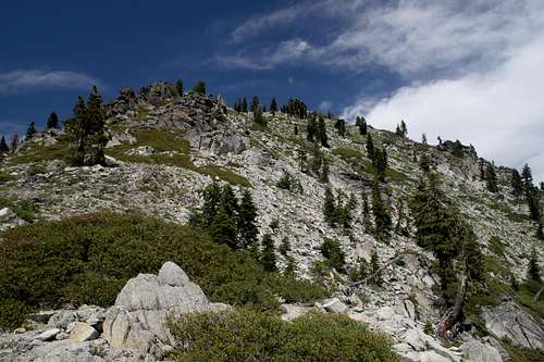
 Looking up the forested ridge climbed by the Granite Peak trail
One thing defines the 4.2 miles of the Granite Peak trail: switchbacks. Nearly the entire length of the trail consists of switchbacks. Starting out at around 3,500 ft, the first mile of the route follows an old jeep trail. The forest is thinner in places as a result of logging activity. This section of trail climbs a long ridge that leads up to the summit. An eastern tributary of Stoney Creek lies far below the trail, although the creek is far enough below the route that it is generally inaccessible. There are occasional views of Mt. Shasta when the forest canopy clears enough to allow views to the north. After 1.0 mile, the trail turns to the west and traverses the flank of Granite Peak. This is one of the longest stretches of trail without substantial switchback activity. Shortly after the trail turns west it crosses the upper reaches of the Stoney Creek tributary. This is the first water source on the trail.
1.5 miles the trail crosses the boundary into the Trinity Alps Wilderness. At this point the trail turns sharply to the north and begins to climb steeply in a seemingly unending series of tight switchbacks. After another mile, the trail enters into a steep gully drained by the East Fork of Stoney Creek. The switchbacks continue, but the trees thin out a bit, the forest opens up a little and wildflowers and granite boulders begin to add interest to the trail. The pleasantness of the trail increases when the forest gives out in places leaving clear views to the south. The clearings are a dominated by brushy areas, but there are some nice grassy patches that add to the pleasant nature of the area.
 The summit of Granite Peak
As the trail moves away from the creek (there is not more water for the rest of the trip to the summit), what appears to be the summit comes into view. Unfortunately, it is a false summit. Nonetheless, the views are excellent. The trail continues to switchback upward for another 0.5 miles until it reaches the junction with the Stoney Ridge Connector trail, just below 8,000 ft. The views from the junction exceed those of the false summit, particularly to the west, where Red Mountain begins to take center stage. 0.3 miles of switchbacks climb the last couple hundred feet to the top of Granite Peak. Once on the summit, 360-degree views take in much of the Trinity Alps, the Klamath Mountains and the California Cascades. The stratovolcanoes Mt. Shasta and Lassen Peak are visible to the east. In addition to the fantastic views, one can also observe the ruins of an old Forest Service lookout. While no one maintains vigil from the lookout, it is still possible to spend the night on the summit of Granite Peak.
Stoney Ridge Connector Trail
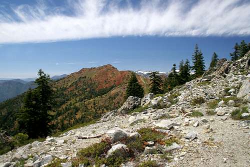 Red Mountain from the Stoney Ridge connector trail
The Granite Peak trail is included on Summitpost primarily because it is the most common route to the summit of Granite Peak. It remains one of the most widely used trails in the Trinity Alps. However, it should be reiterated that it is in many ways a harder and inferior option to hiking up the Stoney Ridge trail to Red Mountain Meadows and then using the Stoney Ridge connector trail to summit Granite Peak. This option can be exercised as either a day hike or an extended trip into the heart of the Red Trinity Alps. If the latter is the case, then the summit of Granite Peak makes an excellent side trip. If one chooses to use the Stoney Ridge trail to summit Granite Peak, it should be noted that the trail is a mile longer, but has 1,000 feet less elevation gain. Trailhead access is roughly the same, so if the summit of Granite Peak is the primary objective, one must weigh the options.
Perhaps the primary reasons why few people climb Granite Peak via the Stoney Ridge trail are its relative obscurity and the lack of maintenance on the connector trail. The Stoney Ridge trail is well maintained, but receives little use. The connector trail to Granite Peak sees even less. Furthermore, it falls into the infamous “scramble” category that is common in the Trinity Alps. The Forest Service designates routes as Scrambles if the trails receive such little use that maintenance is not worthwhile, or if (as is more common) the routes are dangerous enough that the Forest Service does not want to accept culpability for any accidents that may occur. In the case of the Stoney Ridge connector trail, the former reason is the cause for the “scramble” designation. Whatever the reason, the trail is faint in places and some route-finding skills may need to be employed.
 Red Mountain Meadow
The connector trail is about 1.0 mile in length. It departs the Stoney Ridge trail just below Red Mountain Meadows (around the 42nd switchback from the wilderness boundary). The junction is signed. The route traverses a gulch drained by spring fed creeks originating in Red Mountain Meadows. The first creek is crossed immediately after leaving the Stoney Ridge trail. The route continues east through a grassy extension of the meadow. The second creek is crossed at the east end of the meadow, shortly before it turns to the south and enters the forest covering the southern flank of Granite Peak. This is the last water to be found on the trip to the summit of Granite Peak.
The trail continues south for about 0.3 miles, climbing steadily. Eventually the route enters a clearing with south-facing views. At this point the trail all but disappears and numerous game-routes continue to the east. To regain the trail, climb upwards, through the clearing, gradually heading northeast. Eventually one will intersect the trail. The junction with the Granite Peak trail follows shortly thereafter and the route is well maintained the rest of the way to the summit.
Map
