
-
 21326 Hits
-
 81.84% Score
-
 14 Votes
|
|
Route |
|---|---|
|
|
41.23161°N / 122.78458°W |
|
|
Scrambling |
|
|
Spring, Summer, Fall |
|
|
Overview
 East Boulder Lake and the Scott Mountains crest
The East Boulder Lake Loop provides easy access into the interior of the Scott Mountains portion of the Trinity Alps Wilderness. East Boulder Lake is the largest body of water in the Scotts, a range that extends east beyond the Trinity Alps Wilderness before merging with the Trinity Divide. This loop is an excellent day hike, a great short backpacking trip for those with kids or can easily be extended to numerous destinations for longer trips. Although longer and not as direct as the Middle Boulder Lake route up Eagle Peak, it is nonetheless, a preferred route due to all the scenic attractions it has to offer.
The Scott Mountains form the divide between the Trinity and Scott Rivers. Even though less than a mile separates the waters flowing off of either side of these mountains, it is over 50 air miles before they meet again when the Trinity River flows into the Klamath River. It is hundreds of winding river miles before this dramatic reunion. The Scott Mountains form the northern most subrange of the Trinity Alps and are a quintessential part of the Red Trinities; an area typically constituted by red peridotite or serpentine rock, rather than the granite the typifies the area known as the White Trinities.
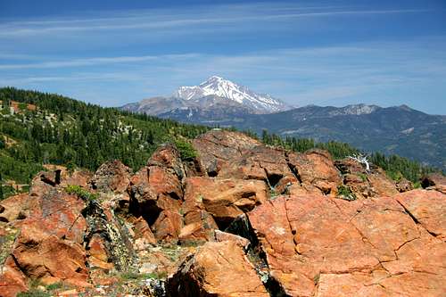 Mount Shasta and Mount Eddy from the East Boulder Loop
The Scott Mountains are distinct among other subranges in the Trinity Alps for a few noteworthy reasons. First, they are the only part of the Trinity Alps traversed by the Pacific Crest Trail. The PCT departs the actual Pacific Crest south of Mt. Shasta and follows the crest of the Trinity Divide (a separate mountain range that forms the divide between the Trinity and Sacramento Rivers, which is not to be confused with the Trinity Alps) to Mt. Eddy. North of Eddy the PCT traverses the flanks of China Mountain, the hinge upon which the Trinity Divide merges into the Scott Mountains. The Scotts are bisected by Highway 3. After crossing Highway 3 the PCT enters the Trinity Alps Wilderness. Only 18.9 miles of the 2,400 miles pass through the Trinity Alps along the Scott Mountain Crest. From there it continues north through the Russian, Marble Mountain and Red Butte Wildernesses before crossing into Oregon and rejoining the Cascade Mountains and the true Pacific Crest.
Another unique attribute of the Scott Mountains is the presence of sagebrush, particularly on the north side of the range. While numerous explanations for why this plant appears here have been attempted, it remains a mystery. Nonetheless, it is surprising when one emerges from the cool forests below East Boulder Lake and finds this arid plant growing alongside extensive, lush, lakeside meadows. The presence of numerous, large lakes is another excellent (although they certainly does not have a monopoly on this commodity) attribute of the Scott Mountains.
Route Description
 Waterfall below the outlet of East Boulder Lake
The East Boulder Lake Loop begins mildly, following East Boulder Creek through a wide, shallow canyon. Craggy Peak, on the highest peaks in the Scott Mountains can occasionally be observed through the fairly light forest cover. The creek remains on the right hand side of the trail, which passes through intermittent meadows. 0.5 miles from the trailhead the route crosses the wilderness boundary, entering the Trinity Alps Wilderness. After another 0.75 miles, the trial begins to climb a little more earnestly, swinging close to a small waterfall a short distance from the outlet of East Boulder Lake. After climbing above the falls, the trail crosses the creek immediately prior to being deposited at East Boulder Lake’s outlet. Up to this point the rock has been granite, most seen in the form of boulders in the canyon. Once above the falls the rock suddenly shifts to stark, red peridotite. The change is fairly dramatic.
East Boulder Lake occupies a large glacial basin. At 32 acres, it is one of the Trinity Alps’ largest bodies of water (though still substantially smaller than massive Caribou Lake which is a massive 72 acres). As states previously, the basin is composed of bright red peridotite. This is, however, contrasted by the incredibly lush meadows that form a thick carpet throughout the entire basin. Sagebrush, seemingly unlikely in such an alpine setting is abundant, particularly on the slopes of the basin walls. Above East Boulder Lake one will find Upper Boulder Lake and two additional, good-sized tarns.
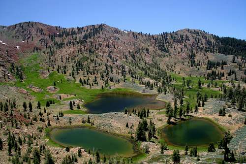 Upper Boulder Lake and its subordinate tarns
At the lake’s outlet a trail branches off to the east. This route climbs the eastern wall of the basin before descending into the cirque containing Mill Creek Lake. The loop continues south, along the west side of East Boulder Lake. The trail arcs to the east, across the inlet stream. Those who desire to reach Upper Boulder Lake should depart the trail here and continue up the basin. The meadow is particularly thick in this area and it may disappear in the meadow. If this is the case, continue southeast, up the knoll and into the trees. The trail should be easier to pick up in this area.
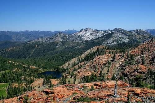
Once through the trees, the route begins to switchback up the basin headwall. Views of Scott Valley and the Russian Wilderness to the north are excellent. A low notch is the trail’s destination. Once reached, an even greater vista than the one witnessed while climbing is revealed. Mount Shasta dominates the horizon to the east. Just below Shasta, the massive bulk of Mount Eddy is visible. The incredible size of this mountain is often lost, overshadowed by the even greater bulk of Mount Shasta. Immediately to the south is Tangle Blue Canyon and the granite towers ringing Big Bear Lake (which is not visible from here). Big Marshy Lake lies in a large meadow network above Tangle Blue Canyon. The high peaks of the Trinity Alps are visible farther to the south. In the far distance, one can make out the Grey Rocks, Crater Peak and Lassen Peak, marking the southern end of the Cascade Range.
 Big Marshy Lake and the Big Bear basin
Below the notch, the trail descends a short distance to the PCT, which can be seen to the east, climbing toward the Scott Mountain crest. Beyond the East Boulder Lake Trail’s junction, the PCT is a fairly level trail slung on the rocky slopes of the Scott’s crest. Views to the south are constant and impressive. The view of Billy’s Peak are great just above a small spring-fed lake. The loop remains on the PCT for nearly 2 miles. It eventually reaches a high saddle where it intersects the Middle Boulder Lake trail.
Climbing Eagle Peak
 Eagle Peak seen high above Middle Boulder Lake
Those who intend to climb Eagle Peak should remain on the PCT for nearly 0.5 miles beyond the junction. Upon reaching the junction with the Telephone Lake Trail, take the trail north to saddle at the top of the Telephone Lake basin. From the saddle, it is a simple cross-country trek up the forest slopes of Eagle Peak. After climbing the peak, one can either backtrack back to the Middle Boulder Lake Trail junction or take the Telephone Lake Trail to the Lake and then travel cross-country down to Middle Boulder Lake. The route between the lakes is steep and there is some brush. For those willing to make the time investment, this is the best route, since it allows one to climb a peak and pass by an extra lake. However, it does create an extended loop of nearly 12.5 miles rather than the normal 10 mile loop.
For those who do not with to climb Eagle Peak or visit Telephone Lake, it is a simple matter of descending the Middle Boulder Lake Trail from its junction with the PCT. The route passes two smaller lakes hidden on a bench high above Middle Boulder Lake. The loop never actually reaches the lake. About halfway between it and the PCT a connector trail leading back to East Boulder Lake branches off of the Middle Boulder Trail and heads north, traversing the Middle Boulder basin’s wall. The trail eventually rounds the wall, entering the East Boulder Basin and rejoining the East Boulder Trail near the lake’s outlet. Simply retrace one’s steps back to the trailhead.
Map

Getting There
 Looking down on Middle Boulder Lake
From Callahan on Highway 3, drive west on South Fork Road to the junction Forest Road 40N17. Continue on 40N17 (sometimes called McKeen Road) to the McKeen Divide. Go south on Forest Road 39N63 and follow this road to the East Boulder Lake trailhead, a total of 9 miles from Callahan.
ktnbs - Aug 17, 2009 7:43 pm - Hasn't voted
brings back memoriesIn 74 I was a seasonal Wilderness Guard for the USFS mostly operating in the Marbles but I did a week in the Boulder Lake area and remember the Klamath and Shasta-T evening fire lookout chatter talking about Nixon resigning.