
-
 22333 Hits
-
 89.77% Score
-
 30 Votes
|
|
Area/Range |
|---|---|
|
|
46.62770°N / 12.98230°E |
|
|
Hiking, Mountaineering, Trad Climbing, Via Ferrata, Skiing |
|
|
Spring, Summer, Fall, Winter |
|
|
7650 ft / 2332 m |
|
|
Overview
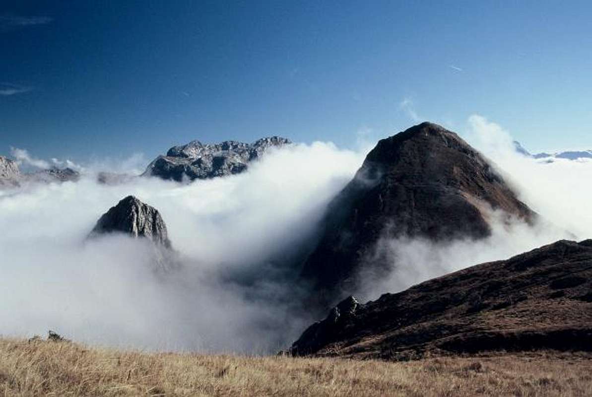 DragoA - Cooking fog
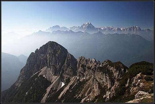 The view from Monte Scinauz
What's New On This Page?
- Nov 24th, 2019: 94 mountains described (see the Google map).
- Aug 25th, 2015: Page completely reworked.
- Sep15th, 2014: Minor changes in design.
- Jan 10th, 2009: Links to Monte Paularo and Monte Dimon.
- Jul 1st, 2008: Links to Kleiner Pal / Pal Piccolo.
The Purpose of This Page
Among mountaineers, who in the European Alps again and again look for new doses of addiction and among writers, who describe these mountains, the Carnic Alps are less famous in comparison with, for example, the neighbouring Dolomites and Julian Alps. And yet they are very beautiful mountains.
Oh, if my memory would only keep more experiences from mountaineering in Carnia, so that I would be able to report more! But it was only a few bright moments, only here and there a visit. And there are still plans, they always remain, sometimes till the very last moment, as unrealistic hope.
So, here I can present you only a modest selection. With good intentions and hoping that, even if about Carnic Alps also others were writing, I can add something interesting.
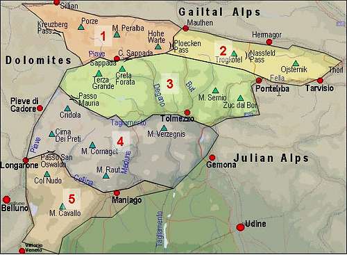
Eastern Carnic Alps Presented
On the picture below you see the five big groups of Carnic Alps. On this page, I'm describing group 2.
The main ridge of Carnic Alps reaches highest altitudes in its central part, just west of Ploecken Pass / Passo di M. Croce Carnico. But while towards the west mountains in the main ridge long retain a high alpine character, towards the east they soon become more humble. Actually, half of this group (from Ploecken Pass / Passo di M. Croce Carnico to Nassfeld Pass / Passo Pramolo) is still high and rocky, while east of Nassfeld Pass / Passo Pramolo the mountains of the main Carnic ridge are more hilly, only some of them reaching altitudes over 2000 m. Of course, judging what is more and what is less beautiful is a matter of different tastes. But anyway, all the main summits are very fine hiking goals and panoramic points.
Borders of the Subgroup
 Carnic Alps - Eastern part, seen from Polinik. (Zuc dal Bor and M. Chiavals are not a part of the Main Range any more.)
It was more or less the agreement among some members of SummitPost how the whole broad group of Carnic Alps will be here divided in subgroups. That is because any 'official' borders of this subgroup are not established. On the north, the border is of course the river Gail/Zilja. Also the western and the eastern boder are clear - Ploecken Pass / Passo di M. Croce Carnico and Thoerl. Let me describe now how the border towards the south was agreed. From Ploecken Pass / Passo di M. Croce Carnico southwards by the river Timau to Paluzza. From there towards the east over Ligosullo to Paularo, so that Monte Tersadia, 1959 m stays out of the subgroup. From Paularo towards the south by Chiarso creek to Dierico and further towards the east on Forca Griffon, dividing Monte Sernio group on the south (outside) and Monte Salinchiet on the north (inside). Now down to Aupa valley, up to Sella di Cereschiatis and further towards the east to Pontebba. From there on by rivers Fella/Bela and Silizza/Ziljica to Thoerl. It is important to mention, that towards the south two nice groups: Monte Sernio / Creta Grauzaria and Zuc dal Bor stay out in the so named: Southern Carnic Alps subgroup.
Geological Outline
 Change of rocks - shales to limestone in the Hochwipfel-Schulter area
 Geological diversity of Carnic Alps - from Polinik limestone, over Koderhöhe shale, back to Creta di Timau limestone (in front)
The Carnic Alps Main Crest is geologically one of the most interesting areas in Europe. These mountains are mostly (more than 95%) built of sedimentary rocks, metamorphic and igneous rocks are very rare. Just north of the Carnic Crest, by the valley of Gail/Zilja, in the west-east direction the so-called Periadriatic lineament runs. It is one of the biggest tectonic disturbances in Europe. South of it we can clearly see how the age of mountains (Southern Alps) is decreasing.
All rocks, deposited in Carnic Alps belong to one of the following 3 sequences:
1. Pre-Variscan. Middle Ordovician to Middle Carboniferous rocks (460-330 million years old).
This sedimentation finished with Variscan orogeny (330-315 million years ago), when a big mountain chain was formed.
2. Permo-Carboniferous. Late Carboniferous to Middle Permian (315 - 275 million years old).
3. Permo-Triassic. Late Permian to Middle Triassic (275 - 235 million years old).
Aftere these two sedimentation sequences, in Late Mesozoic, Alpine orogeny started, forming a big mountain chain, including Alps.
So, the main crest of Carnic Alps is almost entirely composed of very old (510-235 million years) Paleozoic rocks. South of it, in the Southern Carnic Alps (and Dolomites and Julian Alps) beautiful sharp and high mountains are from the Mesozoic era (for example built of main dolomite and various limestones), mostly Triassic. Jurassic rocks are also there, but more rare, and even more towards the south many limestones from the Cretacious period can be found.
Going back to the Paleozoic nature of our Main Crest, we can soon realise how big its variety is. The oldest rocks, Ordovician and Silurian formations, can be found only on small areas, but the highest mountains are built of Devonian limestone (420-360 million years old). These rocks are stretching also across the Passo di Monte Croce / Ploecken Pass, and are forming in the easterm part the summits: Polinik, the range from Monte Pal to Creta di Timau and more eastwards from Monte Lodin, over Monte Zermula to the broad massif of Monte Cavallo di Pontebba / Rosskofel. These are some of the main summits of our area, with nice, quite high rocky walls, also interesting for climbers. Carboniferous rocks (360-290 million years old) are stretching even more towards the East, and form also the southern areas of some aforementioned summits. At that time the sea was deeper, so more rounded and nowadays grassy summits are made of shales, siltstones, sandstones and similar rocks. These, mixed with volcanic intrusions, can be found in the areas of Hochwipfel, Monte Dimon and Monte Paularo, but also in the part of the main crest around Auernig.
To summarize this paragraph: whereever you will see more tender, water-proof mountains of more rounded shapes, grassy till their tops, they are made of shales and siltstones. Whereever you will see more barren, white or grey walls and towers, but permeable for water and displaying some karst phaenomena, they are made of Devonian (and more to the East also some Permian/Triassic) limestone.
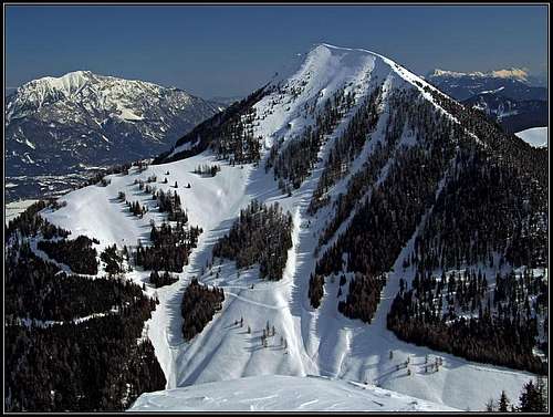
Sedimentation continued in the next, Permian era (290-250 million years ago). Shales, sandstones, clays, limestone etc. were created, but only rare high mountains are from that era. A famous exception is Trogkofel / Creta di Aip, with its red rocks. Finally, only some mountains are of a younger origin. From the Middle Triassic era (240-220 million years ago) are in the Eastern Crest the rocks of Gartnerkofel, the broad southern area of Monte Cavallo and the whole massif of Monte Scinauz.
While thicker or thinner layers of sediments were depositing in the ancient seas, those were not yet any mountains. Huge forces, originated in the movement of Earth crust plates were needed to push those layers up. That happened twice. The first orogenic process was the Variscan orogeny, which happened already in paleozoic (Middle Carboniferous). The surviving mountains of that huge mountain chain are also all the Carnian Paleozoic mountains. The second orogeny (Alpine Orogeny) was the collision of the huge African plate and the European plate, subducting below the former, which is resulting in creation of European Alps. That process started some 100-80 million years ago and even if the major lifting of Carnic Alps had its full development some 40-20 million years ago, that process is still lasting nowadays. Often earthquakes are proving it most dramatically. The last big impact on shaping of Carnic Alps was due to many consecutive periods of glaciation, during the Cenozoic (Neogene) era. That was very recent, only 80.000-10.000 years ago. More than 1000 meters thick glaciers were covering the whole area and only the highest summits were peeking out of ice. When those huge glaciers were moving, they heavilly carved the surface of mountaneous area and also leaving big deposits of rocks in the pre-alpine areas. In many valleys, alluvial (washed) deposits are covering original, older rocks, which would otherwise be shown on the surface.
External links:
> The Paleozoic of the Carnic Alps,
> Geopark Carnische Alpen.
What To Do There?
 Dante - Winter mountaineering, Creta di Timau
The eastern part of Carnic Alps main crest is very diverse also regarding outdoor activities. The summits around the two road passes are very frequented. Nassfeld / Passo Pramollo / Mokrine area is in winter a popular and very big ski resort. But in the area you can also find very remote, still completely wild parts, such as the mountains around Monte Scinauz.
Hiking and scrambling is the first activity to be mentioned. You can choose among a big number of tours of various difficulties, on all of them you are rewarded with great vistas. As you might infer from the geology outline, not all mountains are suitable for harder climbing. But the walls which are appropriate, are well explored and host quite big numbers of routes. Many crags are arranged for sport climbing.
In winter and spring tour skiing is very popular. Some summits are well known even beyond the borders of the area. Find in one of the next chapters the list of best summits for skiing.
Canyons and gorges are hiding some spectacular areas, so many of them were opened for visitors and can be reached also without any special equipment. To visit some karst caves, however hiring a guide and coming with a proper equipment is a must. An finally, also mountain biking must be mentioned. You can find in the area the routes of all difficulties and some of them can be also very high and long.
Important Mountains
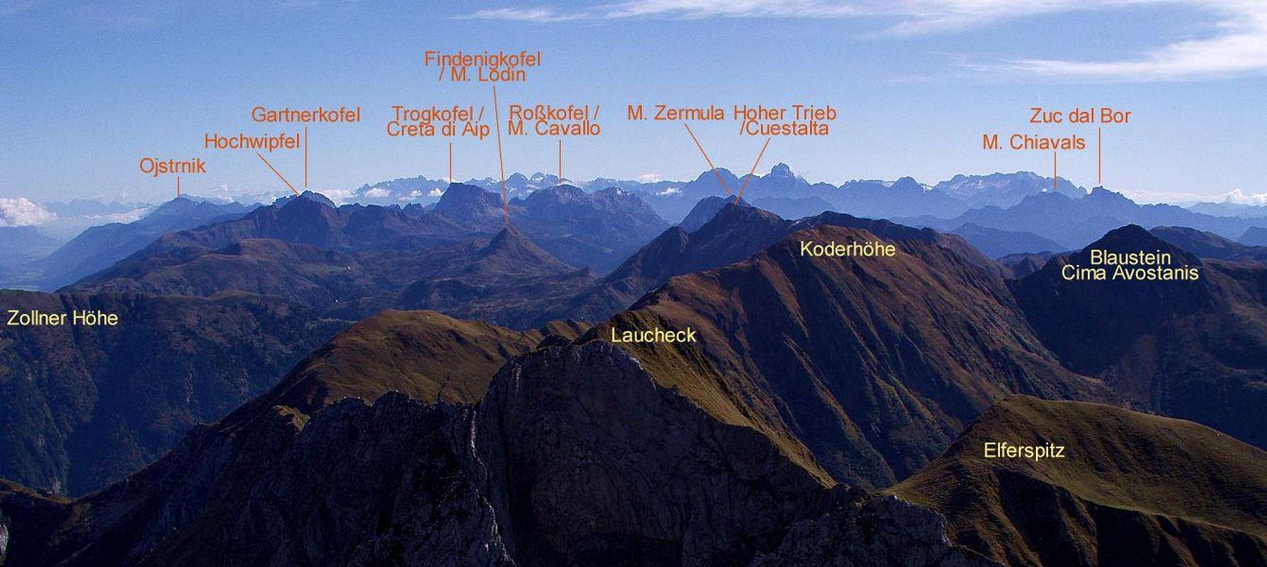
Blue mountains: SP pages. Dots: Other described mountains. Activate the second layer to display mountain huts in the group.
 From Polinik
Group A. East of Ploecken Pass / Passo di M. Croce the main Carnic ridge rises slowly until it finally reaches the altitude of 2217 m on Creta di Timau / Hocheck. But the highest mountain of this subgroup stands north of the main ridge. Polinik, 2332 m is beautifully shaped, towards north it shows a high and steep rocky face. It is also interesting as a ski tour mountain, downhill can be done over its southern slopes, where also the normal approach goes. In the main ridge the next important mountain is Hoher Trieb / Cuestalta, 2199 m, which sends also a side ridge towards the north - in this side ridge the last important higher summit is Zollnerhoehe, 1961 m. In this part, south of the main ridge also a small subgroup stands, actually consisting of two close and equally high summits: Monte Paularo, 2043 m and Monte Dimon, 2043 m. And one more interesting thing: Gangolf Haub recommends to mention the open air World War I museum, which is on Kleiner Pal, just above the Ploecken Pass.
 Andrej Mašera - Creta di Aip / Trogkofel
Group B. Further towards the east, beyond a 1554 m high saddle Hochwipfel, 2195 m is a more outstanding mountain. It is positioned a bit north of the main ridge, which continues to the high and elegant Creta di Aip / Trogkofel, 2230 m. While the main Carnic trail passes it by the southern side, the summit of Trogkofel can be reached by three interesting marked routes, two of them being true ferratas. South-east of Trogkofel, the main ridge lowers a bit, but soon sends a strong side ridge further towards the SE. The highest point in this ridge is Monte Cavallo di Pontebba / Rosskofel, 2238 m, which can be also reached by attractive routes. At the end of this subgroup description we must again return a bit towards west. South of Hochwipfel, and divided from the main ridge by Rio Lunza (creek), stands a dominant Monte Zermula, 2143 m. Besides two normal routes the summit can be ascended also from north by an interesting ferrata. Because of the road, which encircles it, Monte Zermula is very popular for visits. It can be reached in 1 h 30 min. South-east of Monte Zermula there are some more mountains, streching their ridges in different directions, but they are much lower.
 Summits above Nassfeld
Group C. So we reached the Nassfeld Pass / Passo Pramolo. On its northern, Austrian side a big and modern ski center is operating. In the mountain subgroup east of the pass the main ridge rises only moderately to the altitude of 2000 meters, but the main summit stands again north of it. Gartnerkofel, 2195 m, is a nice, rocky mountain, showing towards the north its most beautiful face. Besides being popular for summer hikes, it is also a nice ski tour mountain. From Nassfeld Pass / Passo Pramolo some altitude can be gained by ski-lifts, then moderately steep slopes bring you to the saddle between the SE ridge and the summit and finally you climb the last 200 meters. For downhill you will probably choose the ascent route, but you can also ski deep down around the eastern side and towards the north.
 Around Cima Bella
Group D. East and south-east of Gartnerkofel there is a broad area of mountains, which don't reach 2000 m of altitude. While the summits of the main ridge are often visited, the southern part is less popular for mountaineering. Monte Schinauz, 1909 was once hosting a NATO radar system, so it's reasonable that there are not many marked paths. North of the main ridge a nice area around Egger Alm (pasture) and Egger Alm See (lake) can be reached by a mountain road, which ascends to an altitude of some 1500 m. Among mountains in the main ridge the most popular for hiking, and especially for tour skiing are: Poludnig/Poludnik, 1999 m, Monte Cocco / Kuk, 1941 m and Cima Bella / Schoenwipfel, 1913 m. Especially the easy ski tour from the last one towards the south-east is a pure poetry and can be done any time in winter or spring.
 From Gorjane
Group E. Finally on Oisternig/Ojstrnik, 2052 m, Carnic Alps for the last time exceed the altitude of 2000 meters. This mountain is a beautiful panoramic point and is very popular for hiking and tour skiing. From the north-east a narrow roads reaches the saddle below its summit and marked hiking paths ascend on its summit from all sides. Skiing is usually done first by its south slopes and then either by its long north-east ridge on the Austrian side or by valleys towards south-west on the Italian side. East of Oisternig/Ojstrnik the main ridge slowly loses altitude. More towards the east an independent summit is Goriane / Gorjane / Goeriacher Berg, also a wonderful panoramic point. Then the Carnic range finally descends completely towards Thoerl and the Silizza/Ziljica river.
Tour Skiing
 Great slope for skiing - Ojstrnik NW
Because of their special value for tour skiing, here I shall only name summits, which are most important in this respect:
Group A. Grosser Pal, 1814 m, Creta di Timau / Hocheck, 2217 m, Promos, 2195 m, Polinik, 2332 m, Elferspitz, 2254 m, Laucheck, 2156 m, Hoher Trieb / Cuestalta, 2199 m, Zollnerhoehe, 1931 m, Monte Dimon, 2043 m, Monte Paularo, 2043 m, Noeblinger Hoehe, 1760 m, Waidegger Hoehe, 1961 m, Leitenkogel, 1845 m, Cima Val di Puartis, 1927 m.
Group C. Gartnerkofel, 2195 m.
Group D. Poludnig/Poludnik, 1999 m, Cima Bella / Schoenwipfel, 1913 m, Monte Cocco / Kuk, 1941 m.
Group E. Oisternig/Ojstrnik, 2052 m.
Routes - A Map-Guidebook
As usual, all routes are described in detail on each of the mountain pages. However, below you can find the new interactive map - guidebook. Explore it, click on features to get descriptions, pictures etc. If you want a different background (for example a more detailed OpenStreet map), click on the arrow on the left.
The map is not finished yet. But soon I will describe on it all mountains, routes, landmarks etc. of this area. Later, I will maintain it regularly.
Gorges of Carnic Alps
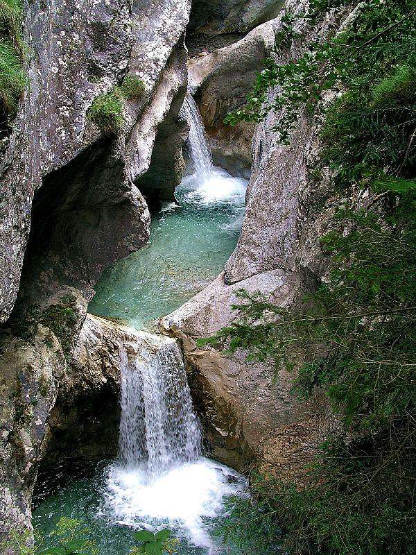 Garnitzen Klamm
Eastern Carnic Alps have a few nice gorges, which are arranged for touristic visit. Some represent a true mountain tour - even a quite hard ferrata. And it has a sound reason. In a hot and hazy summer day it is perhaps good to do a change in mountaineering plans and visit one of these beautiful, shady river beds, like Garnitzen Klamm or Mauthner Klamm.
Contribution by Gangolf Haub: Garnitzen Klamm Garnitzen Klamm is one of the longest gorges in Austria's southern-most state Carinthia. It is divided into four sections, the three lowest ones of which can be hiked along trails, ladders and bridges while the uppermost section is an exposed ferrata, secured by fixed chains. The gorge runs from the town of Hermargor south-westward towards Gartnerkofel where it ends to the west side of the mountain. The trail through Garnitzen Klamm is conceived as a so-called Geo-Trail, with lots of presentation boards describing the geological formation of the Carnic and Gailtal Alps. The central part of the gorge (section 2) is by far the most beautiful. The gorge narrows to about 5 m width with vertical or overhanging walls towering some 500 m above. There are three entry points - one at each end and one near the centre, where you can reach the bottom of the Klamm from the west. Near this entry point you can find Garnitzen Haus, a bivouac which you can use in times of need. Due to the narrowness of the gorge sudden weather changes can become quite dangerous. The rock gets slippery and you have to account for rushing floods covering the gorge floor in very short times. Thus the trails can get flooded and reaching one of the three entry/exit points may require climbing of up to UIAA III (5.4). So check for weather before you enter the Klamm. Red Tape: At the Hermagor entry/exit you have to pay for a 2€ access ticket. (See pictures also on Gartnerkofel, page!)
 |
 |
 |
 |
 |
Ethnologic Remarks
Women porters of Carnia
During the World War I the frontline went along the whole Carnic Alps Main Crest. On the Italian side, due to lack of people, many local women were engaged as porters. Their legendary job was to supply the first front lines, carrying daily over more than 1000 meters of altitude on their shoulders 30-40 kilos of supplies and ammunition, while many of their men were fighting on those mountains. Many of them became famous, the most legendary was Maria Plozner Mentil from Timau. Mother of 4 children was on February 15th, 2016 killed 32 years old by an Austrian sniper and was later honoured with the Italian golden military order.
Gailtal cheese
It is documented that on the alpine meadows above Gail / Zilja valley excellent cheese has been produced since 13th century. Today a community of 13 producers are selling it on alpine meadows along the Austrian Karnisches Hohenweg (long distance trail) - the trade mark is 'Gailtaler Almkäse'.
Getting There
For the broader orientation see the Eastern Alps GROUP page, and, because this is only a subgroup page, the Carnic Alps page.
Red Tape
Generally, there are no restrictions in the area. The only exception is the valley of Rio Bianco, east of Monte Scinauz, which is completely closed for visit (as a natural reserve). However, when visiting, have the following in mind:
- Some mountain roads are closed for public traffic. On Tabacco maps these are indicated.
- To enter Garnitzenklamm (canyon) from below, you need to pay a small fee.
- Some paths are time to time closed and you can use them on your own responsibility. (2015: The gorge of Vorderberger Wildbach).
When To Climb
Mountains of the eastern part of Carnic Alps main ridge can be climbed in all seasons. Of course there are certain specifics. Mountains mentioned to be harder for climbing should be best done in summer and autumn, other mountains are nice to hike in all seasons. Doing ski tours again depends on current snow conditions and on demands of a tour. For weather conditions, see the main Carnic Alps page!
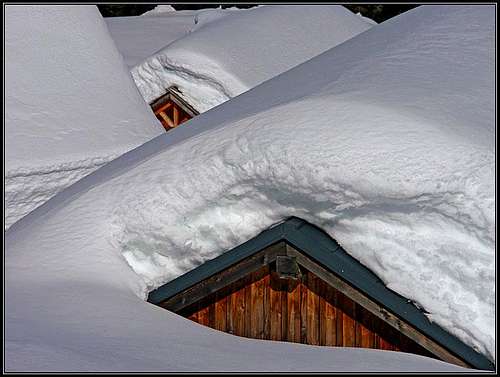
Camping and Accomodation
 Dolinca huts
On the main Carnic Alps page you can find links to some more important tourist resorts in the area. There are also some links on moutain huts pages. Huts are not so frequent in the eastern part as in its western counterpart. On the Google map above, switch on the second layer and you will get their positions!
- Ploeckenhaus, 1208 m.
- Ricovero Casera Palgrande di Sopra, 1705 m. Bivouac below Creta di Timau, 15 places, allways opened.
- Casera Pramosia Alta, bivouac with 10 places.
- Dr. Steinwendner hut, 1720 m. Opened from mid June till end of September. 28 places + 6 in winter room. Tel.: 0043/4718/625.
- Rif. Pietro Fabiani, 1539 m. Opened mid June till mid September. Tel.: 329-3009876.
- Straniger Alm (Zollner Huette), 1501 m. Opened mid June till mid September. Tel.: +43(4285)243.
- Rattendorfer Alm, 1531 m. Tel.: +43 664 5121538.
- Casera Cason di Lanza, 1552 m. Opened from start of May till end of October. 14 places + 6 in winter room. Tel.: 042890928.
- Rudrigalm, 1622 m.
- Naßfeldhaus, 1528 m, opened all summer. Tel.: +43 4285 82710.
- Rif. Fratelli Nordio, 1210 m.
- Dellacher Alm, 1362 m.
- Koutschitzalm, 1100 m.
- Starhand hut on Lom saddle, 1460 m, private. Opened from mid May or start June till end of October, 7+15 beds, tel.: 04283/2004.
- Feistritzer Alm, 1718 m, private. Opened from May till September, 8 beds.
- Schoenwipfel Schutzhaus, 1715 m. Opened in July and August, 10 + 5 beds, tel.: 04256/3163.
Maps & Books

- Guidebook in Italian: R. Gaberscik: Guida escursionistica alle Alpi Carniche. STUDIO64srl Edizioni. 7th edition, 2010.
- Guidebook in German: P. Holl: Karnischer Hauptkamm. Alpenvereinsführer. Rother Verlag. ISBN: 3-7633-1254-4. An excellent overall Climbing Guide through the Carnic Alps Main Ridge.
- Guidebook and photomonography (in Slovenian): V. Pogačnik: Kar na Karnijce. Založba Narava, 2011. For the rest, see the main Carnic Alps page!
- Martin Fürnkranz: Skitouren am Nassfeld und auf der Egger Alm. Excellent on-line guidebook, regularly updated.
A More Distant History Of This Page
 dante - Farewell
- July 18th, 2007 - Links to the new SP page added: Hoher Trieb / Cuestalta.
- May 29th, 2007 - Links to the new SP pages added: Hochwipfel, Findenigkofel / Monte Lodin.
- October 18th, 2006 - Links to new SP pages added: Polinik and Creta di Timau / Hocheck.
- September 17th, 2006 - Links to the new SP page added: Poludnig/Poludnik.
- July 5th, 2006 - Links to the new SP page added: Gartnerkofel.
- November 13th, 2005 - Links to the new SP page added: Monte Cavallo di Pontebba / Rosskofel.
- June 13th, 2005 - Added links to two (unfinished) pages: Monte Zermula and Creta di Aip / Trogkofel.
- January 10th, 2005 - Links to the new SP page added: Cima Bella / Schoenwipfel.
- January 9th, 2005 - Map updated with two important summits: Pizzo di Timau / Hocheck and Promos/Blaustein.
- January 7th, 2005 - Links to the new SP page added: Ojstrnik.
- January 5th, 2005 - Data about three more huts added.
- November 30th, 2004 - A new chapter added: Gorges of Carnic Alps.
- October 22nd, 2004 - Initial set up of the page.
Your Help Needed
 Help!
Help!More specific calls for your help are also on some of the mountain pages, here are only the most important pieces of information, which are missing for this mountain group.
- Can you in detail describe any of harder climbs?
- Would you consider worthwile to post any mountain north of the main crest?