Monte Cavallo di Pontebba / Rosskofel from the south - from Malga Glazzat Alta
From the north-west
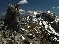
From the NE
Creta di Rio Secco from the W
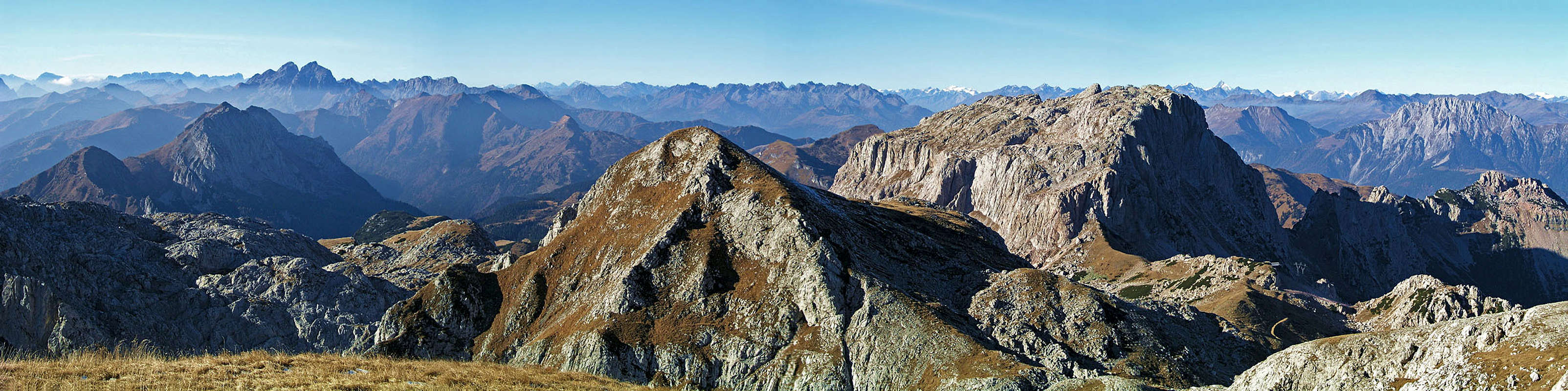
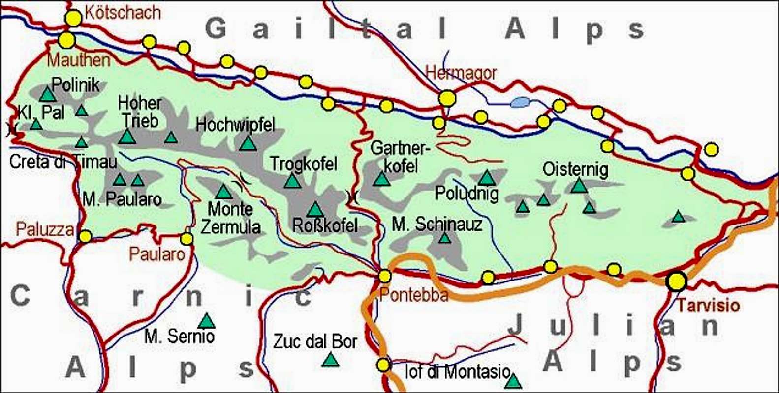
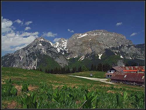
East and west of Nassfeld / Passo Pramolo saddle the mountains of Carnic Alps main ridge rise for the last time with rocky towers and walls. Creta di Aip / Trogkofel, 2280 m and Monte Cavallo di Pontebba / Rosskofel, 2240 m are standing on the western side of the saddle, while Gartnerkofel, 2195 m is standing on the eastern side.
Like in the highest part of Carnic Alps, in Monte Coglians / Hohe Warte group, also Monte Cavallo di Pontebba / Rosskofel is made of Devonian (Paleozoic) limestone. Its quality is mostly good, not too friable.
Monte Cavallo di Pontebba / Rosskofel, 2239 m, is actually a small massif, consisting of some peaks and rocky towers. On the otherwise very good Tabacco map (No. 018) the highest point of the massif is due to an error the summit of Creta di Pricot, standing a bit towards the East of the summit of Monte Cavallo di Pontebba / Rosskofel, marked with 2252 m. Its correct altitude is 2233 m. Even more towards the East, the main ridge of the massif is lowering, but the point 2203 m is still a strong rocky peak and even the last rocky elevation, Anticima Est, 1971 m, looks from the eastern side like a powerful bastion. All these peaks are forming towards the North a nice, up to 500 m high north face, which is so beautifully seen from the nice Winkel valley below it. When you reach the summit over the N wall, you find yourself on a broad, grassy plateau, and you wouldn't think that also the southern slopes of the massif are very steep and rocky. No normal route goes over them and only when going by the East ridge route, you realise, how steep and rocky also those southern slopes are.
North of the summit of Monte Cavallo di Pontebba / Rosskofel the massif ridges branch. Beyond the Notch 2025 m (Forca Clampil) two sharp towers stand, closing the upper part of the Winkel valley. These are Torre Clampil, 2079 m and Torre Winkel, 2040 m. Even more towards the NE, there's the rounded summit of Madritschen / Monte Madrizze, 1918 m, which is reached by a cable car.
The second crest branches/continues towards the West. The first high summit in it is Creta di Pricotič / Hinterrosskofel, 2225 m which is separated from the rest of massif with two notches. Mountains further towards the West are less significant and are lowering down into the Valle di Aip, while towards the South quite a strong ridge goes, culminating first in the Creta di Rio Secco / Trögl, 2203 m, and then lowering more significantly down to the Val Pontebana. In the chapter of routes description, some more side summits will be mentioned.
Also in a mountaineering sense Monte Cavallo di Pontebba / Rosskofel is very diverse. No ascent on it is just an easy hike. The easiest one is coming from the NW, from Sella di Aip / Rudnig Sattel (saddle), but also this one has a few stretches of easy climbing (UIAA I-). By the East ridge a very demanding marked path ascends, it's actually an exposed easy climb (UIAA I), protected by a fixed rope only on one (not the hardest) place. Over the North face a very nice marked route goes. It is not protected and requires on a long section (some 200 m of altitude) easy climbing up to (UIAA II+). In Torre Clampil and Torre Winkel there are two real ferratas, one of them very hard. Many ascents on side summits are not marked and all require easy scrambling or climbing up to UIAA degree II. And finally, rocky walls of the mountain massif offer also some opportunities for harder climbs. In Good conditions it is possible to ski down by the normal ascent route. Also the western summits are suitable for skiing, if one has appropriate skillls.
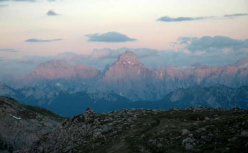
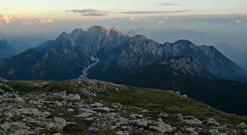
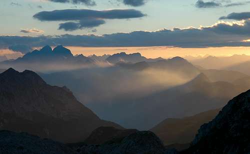
Like from all summits in the Carnic Alps main ridge, also from Monte Cavallo di Pontebba / Rosskofel you have a great panorama on all sides. The contrast between icy summits of Hohe Tauern on the North and rocky summits of Carnic and Julian Alps on the South is very nice. And on the West, the Dolomites mountains are clearly seen.
A few quick ascents come from the Winkel valley, lying on the north-eastern side of the massif. It can be reached from the road over Nassfeld Pass / Passo Pramolo. Just below the saddle, on the Italian side, there's a sharp turn (and a hut), where the forrest road deters into the valley. The road is closed for public traffic.
The second even quicker option from the North are many trails which reach the main Carnic Alps ridge from the Austrian side, from the ski arena Nassfeld. Many paths, among them the famous Karnischer Hoehenweg / Traversata Carnica, reach there, but forrest roads and alpine meadow roads on the Austrian side are also closed for public traffic. The quickest option is the upper station of Madritschen cable way, reaching 1818 m. Another good trailhead is on Rudnig Alm, 1612m, where you can come by car (toll free).
The third option are approaches from the South. They all start in the beautiful and remote Val Pontebbana. From Pontebba, lying on the Udine-Tarvisio highway, a narrow and often bad road deters towards the West into Val Pontebana. One trailhead starts in Studena Bassa village, 630 m, the other one on Carbonarie, 1055 m, the third one by the Caserute hut, 1419 m, and the last option is Passo del Cason di Lanza, 1552 m, from which a mountain road, closed for public traffic, ascends high towards the Carnic Alps main ridge - the trailhead is on 1750 m.
This is an interactive map which is at the same time also a guidebook, describing all the routes which are listed in the next chapter.
The source of routes information was in most cases the excelent book of R. Gaberscik.
Use + and - to see more/less details, click on features to read descriptions, see pictures etc. To switch to other backgrounds, for example a more detailed OpenStreet Map, click on the arrow button on the left.
Red= Marked routes, Brown = Unmarked, scrambles, easy climbs.
Hikes, Scrambles and Protected Routes
The whole area is very nice for hiking. You can do nice round tours, crossings of the whole massif ar just one-way and back tours. Due to high trailheads the tours are short, but from Pontebbana valley you can choose also very long ones. From Passo Pramollo / Nassfeld Pass you can also do easy and panoramic hikes along the Madritschen/Madrizze ridge. You will gain some 400 meters of altitude, unless coming with a cable-car just on top. Going by the ridge avoid the devastated areas due to ski terrains - keep more towards the Italian side.
NE route (normal). Easy climb/scramble (I-), from Forca dei Claps (marked path) 40 min.
S-SE route. Easy climb (I), from Vallone di Pricotič (marked path) 1 h 10 min.
S-SE route, variant. Easy climb (I), from Vallone di Pricotič (marked path) 2 h 10 min.
From Carbonarie in Val Pontebbana. Easy climb/scramble (I-), 4 h.
SW descent. Scramble, steep, not appropriate for ascent (screes).
W-NW route. Easy climb/scramble (I-), from Casera di Aip 2 h 10 min.
N route. Easy climb/scramble (I-), 1 h from marhed path.
Creta di Pricotic, 2225 m
Fiercely is guarding
E route (normal). Hike up, 20 min from marked path.
Crossing from M. Cavallo. Hiking, 20 min.
S route. Easy climb/scramble (I-), from marked path 1 h 15 min.
W route. Easy climb/scramble (I-), from marked path 40 min.
N route. Easy climb (I), from Rudnig Sattel 1 h, from marked path 30 min.
Monte Cavallo di Pontebba / Rosskofel, 2239 m
On the E ridge
East Ridge. This is perhaps for non-climbers one of the most interesting approaches. From Baita Winkel (hut), 1470m, towards the SE on Sella della Pridola (saddle), 1644m. This saddle can also be reached from the south, from Conca di Pricot (alpine meadow), which can be reached by the road (closed for public traffic) from Studena Bassa village). From the saddle over the E ridge over all fore-summits to the highest point. 3h from the Winkel parking place. Steep, exposed, easy climb (UIAA I).
Via F. Schiavi. A very nice route over the N face. From Baita Winkel (hut), 1470 m, towards the W in the basin below the N face of the main summit. From there in an easy climb (UIAA II+) over the wall to the main summit. 2 h 30 min.
Ferrata Contin. As in #2 from Baita Winkel (hut), 1470 m, towards the W in the basin below the N face of the main summit. There continue towards the W on the notch 2044 m, below which the ferrata starts. Over the rocky part and towards the S to the summit. 2 h 30 min. Ferrata is not difficult (Austrian grade B), nor is it too much exposed.
On Madritschen/Madrizze ridge
From Sella di Aip / Rudnig Sattel, 1942 m. This is the normal, NW ascent route. It is marked, but a few places require some easy climbing (I-). The saddle lies on the Carnic Alps main ridge and can be reached from many sides. You'll need some 2 h from various starting points on the Austrian side, some 2 h from Passo del Cason di Lanza or from the Caserute hut in Val Pontebana, and some 4 h from Studena Bassa in Val Pontebana, via Conca di Pricot (meadows) and further below the whole S and W face of the massif. From Sella di Aip / Rudnig Sattel the marked path ascends by the Austrian territory towards the SE, reaches the summit plateau close to the exit of the ferrata Contin and continues towards the S to the top. 1 h from the saddle.
For a descent to Madritschen cable car a shortcut can be recommended. Just before reching down on Rudnig Sattel, you can turn right and descend by a marked, weak path to Traversata Carnica. Then by it towards the east.
> W-SW route. Climbing not needed, easy scramble up. 1 h 30 min from the marked path.
Torre Clampil, SW (normal). Easy climb (I), 15 min from Forca Clampil.
Ferrata Torre Winkel - traverse Torre Clampil. Easy ferrata (A/B), exposed, a few passages of UIAA I. 50 min from marked path or from Madritschen Joch. Some 20 min more if the lower part of E ridge is included.
NE wall, Lomasti-Ceccon. E. Lomasti, A. Ceccon, 1977. VI, V+, 200 m.
NE wall, Via Ermanno. A. Ceccon, G. Domenis, 1971. IV+, III, 250 m.
NE wall, Gollino-Marinelli memorial route. E. Lomasti, A. Ceccon, 1978. VI-, V+, V, 350 m.
NE wall, Via Guerrino Di Marco. V. and E. Di Marco, 1976. V+, A0, V, 400 m.
NE wall, Andrich-Donadelli. Andrich, G. Donadelli, 1969. V, IV, 400 m.
NE wall, Urli-Ceccon-Domenis. B. Urli, A. Ceccon, G. Domenis, 1969. III+, III, 450 m.
Creta di Pricot, NE and E wall
NE wall, Urli-Ceccon. B. Urli, A. Ceccon, 1966. III, II, 450 m.
NE wall, Holl-Gallhuber. P. Holl, H. Gallhuber, 1976. IV+, IV-, 450 m.
NE wall, Via Pontebba. E. Lomasti, G. Casati, 1975. V, IV+, 450 m.
NE wall, Via Trevisan. G. Trevisan, R. Paganello, 1969. VI+, III+, 450 m.
NE wall, Via Buzzi-Buzzi. C. G. Buzzi, G. Buzzi, 1950. III, II, 450 m.
NE pillar. E. Lomasti, S. Piussi, 1976. VI-, V+, V, 250 m.
NE wall, Left ravine. Candidi, Gransinic, Prividori, 1968. III, II, 350 m.
NE wall, Mazzilis-Di Leonardo. R. Mazzilis, L. Di Leonardo, 1980. V+, V, 350 m.
NE wall, Via Mario Pesamosca. V. & E. Di Marco, S. Piussi, E. Lomasti, 1975. IV, III+, 350 m.
NE wall, Ceccon-Palla. A. Ceccon, F. Palla, S. Piussi, F. Buzzi, G. Donadelli, 1979. V, IV, 250 m.
NE wall, Vogric-Di Leonardo. Cl. Vogric, M. Di Leonardo, 1979. IV+, IV, 250 m.
NE couloir. III, II.
E wall, right cimney. E. Lomasti, A. Ceccon, 1978. VI-, V+, 250 m.
E wall, Via Mirta. E. Lomasti, A. Ceccon, S. Piussi, 1976. VI-, A1, V+, 250 m.
E wall, New route. E. Lomasti, R. Mazzilis, 1978. VI, V+, 250 m.
Roßkofel / Monte Cavallo, S walls
SW pillar. E. Lomasti, A. Ceccon, R. Mazzilis, L. Zilli, 1978. V, IV, III, 300 m.
Right SW pillar. III+, III, II, 250 m.
Creta di Pricot, S walls
SW chimney. E. Lomasti, 1978. II, 120 m.
SW wall, Left edge. E. Lomasti, R. Mazzilis, 1978. V+, V, 150 m.
SW wall – Slabs. E. Lomasti, R. Mazzilis, 1978. VI, V, 150 m.
Torre Winkel
Torre Clampil, 2097 m, Torre Winkel, 2040 m.
N wall. F. Wiegele, W. Jaklitsch, 1974. V-, IV, 220 m.
N rib. F. Unterluggauer, F. Wiegele, 1979. III, II, 180 m.
N rib, Direct route. F. Unterluggauer, F. Wiegele, W. Kovsca, 1979. V, A1, IV, 180 m.
E ridge. III, II, 250 m.
Torre Winkel, S pillar (with exit variant). E. Lomasti, S. Piussi, 1977. VI, V, 160 m.
Torre Clampil, S pillar. R. Sepperer, F. Unterluggauer, F. Wiegele, 1975. V, IV, 160 m.
Torre Clampil, S wall. F. Unterluggauer, F. Wiegele, 1975. V-, IV+, IV, 150 m.
The "Klondike Cave"
On Rosskofel one can find also many geological features. Its 300 million years "younger" rocks (from the end of Carboniferous era) are lying on older layers of limestone. In the vicinity of the so-called "Schneefinken basin", which separates the smaller side peak of Rosskofel from its main massif, on the altitude of 2,130 meters, there is the entrance into the "Klondike cave". It is the largest and longest of the four currently known cave systems in Rosskofel. The cave extends to the altitude of 1,453 m, forming different sized halls, tunnels and drainage systems. From the cave entrance in the winter warm air flows, indicating a connection with exits on the south side of Rosskofel (chimney effect). The water level in the cave varies according to season and weather. The most impressive drainage system is the "Yukon", an underground karst river at the bottom of the cave.
The cave can not be entered without speleologic equipment and experience!
Red Tape
In Winkel valley
Wikel valley is like a parc
There are no limitations.
When To Climb
To ascend Monte Cavallo di Pontebba / Rosskofel it is best to choose dry seasons. The best months should be July-October. In 2005 we also had great conditions mid November. When snow and ice covers the mountain routes might become very demanding, requiring full winter equipment.
For weather conditions, see the main Carnic Alps page!
Mountain Huts
The ascent can be normally done in one day. On Nassfeld Pass / Passo Pramolo there are many hotels, but the majority of them is opened during the ski season.
On Passo del Cason di Lanza, 1552 m, there's Casera Cason di Lanza (mountain hut).
At the end of Valle di Aip, close to Sella di Aip / Rudnig Sattel, there's Bivacco Ernesto Lomasti, 12 places, 1900 m.
Books
R. Gaberscik: Guida escursionistica alle Alpi Carniche. Studio64srl Edizioni, 2010 (7th edition), Genova. In Italian.
P. Holl: Karnischer Hauptkamm (Alpenvereinsfuehrer). Bergverlag R. Rother, Muenchen, 1988 (2nd edition). In German.
Guidebook and photomonography (in Slovenian): V. Pogačnik: Kar na Karnijce. Založba Narava, 2011.
What's New Here?
December 13th, 2020: Google map replaced by a new U-Map (based on OpenTopo map or OpenStreet map).
December 23rd, 2013: Complete review of the "Routes" chapter. A detailed Google Map embedded with all hiking, scrambling and easy climbing routes. SP V3 design updated.
August 2nd, 2009: The links to the last two added routes: NW ascent and Ferrata E. Contin.
May 29th, 2009: The S face and W face pictures added, also the link to Via Ferrata dell'Amicizia - "Torre Clampil"/ Kletterstieg der Freundschaft - "Winkelturm/Clampil".
Children refers to the set of objects that logically fall under a given object. For example, the
Aconcagua mountain page is a child of the 'Aconcagua Group' and the 'Seven Summits.' The
Aconcagua mountain itself has many routes, photos, and trip reports as children.
Parents refers to a larger category under which an object falls. For example, theAconcagua mountain page has the 'Aconcagua Group' and the 'Seven Summits' asparents and is a parent itself to many routes, photos, and Trip Reports.

 19044 Hits
 93.58% Score
 43 Votes


 In the neighbourhood
 ganesh70 - Torre Clampil