The summit of Kleiner Pal / Pal Piccolo out of the trenches
On the high plateau - the Italian path
The summit of Kleiner Pal / Pal The WW1 settlement remains
On the summit plateau
Summits, described here
> Kleiner Pal / Pal Piccolo, 1866 m, > Freikofel / Cuelat, 1757 m, > Grosser Pal / Pal Grande, 1809m.
General
It would be nothing so special on Kleiner Pal / Pal Piccolo, if there were not two circumstances, which made it to be one of the most frequented summits in the area. The first one is of course the nearness of the road over Ploeckenpass / Passo di Monte Croce Carnico. Since the times of Ancient Romans the road over this saddle is connecting southern lands with the valleys more central in the Alps. The road was called "Via Iulia Augusta" and many remains are today exposed for tourist visits. And Kleiner Pal / Pal Piccolo rises just above the saddle, only good 500 meters higher. The second circumstance is a more sad one. It is the war. During the World War I, as along the whole main ridge of Carnic Alps, the frontline crossed the summit. As there is a small plateau, both armies were entrenched very close to each other and many military objects were built on both sides. It is all abandoned today, but the area is arranged as an open air museum, another reason for attracting a lot of people.
Actually, Kleiner Pal / Pal Piccolo has much more to offer. First, many hiking routes ascend the mountain. You can choose among many possible round tour combinations. Directly over its western fore-summit a hard ferrata ascends Kleiner Pal / Pal Piccolo. It is a modern type ferrata, exposed and requiring much strength, also in hands. The southern slopes of Kleiner Pal / Pal Piccolo are on a few places almost completely vertical. Those crags are very popular for more difficult climbs, you can find there a wide range of routes difficulties. And it's only some 20 minutes of walk from the parking place. Finally, here is a very fine view from the summit, the neighbouring mountains are shown from a somewhat different perspective.
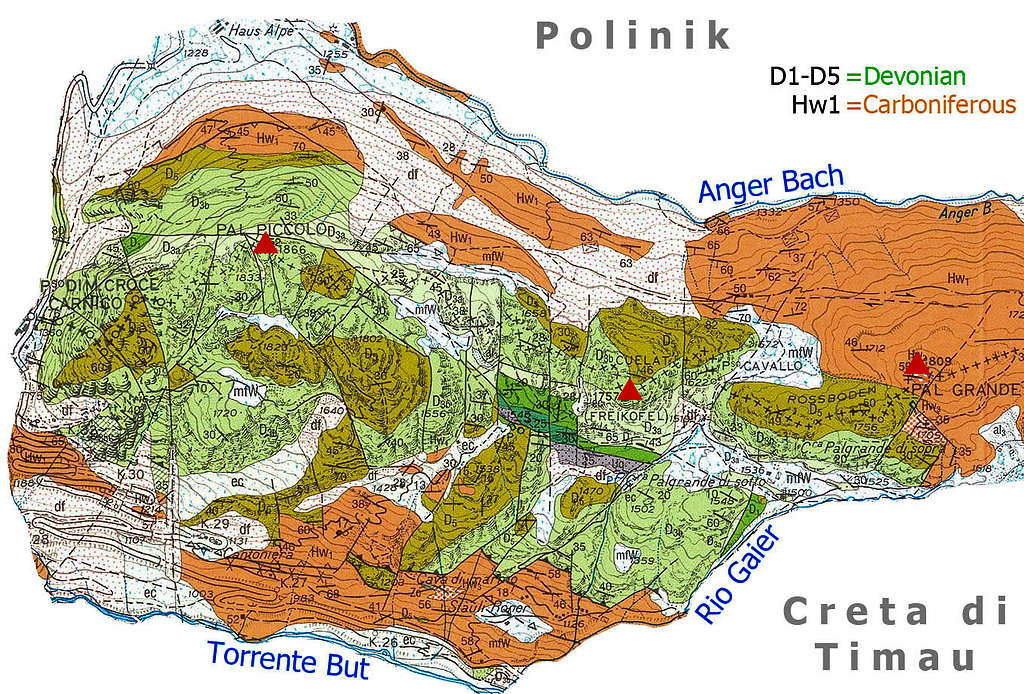
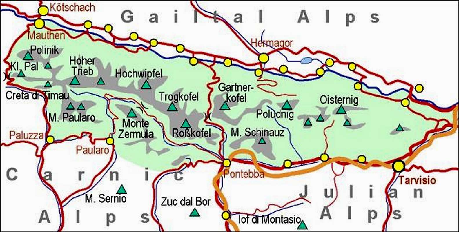
The mountain area from Ploeckenpass / Passo di Monte Croce Carnico, 1360 m (it's a relict of an ancient river bed, modified by glaciation), on the west, till Tischlwanger Toerl / Passo di Pal Grande, 1760 m, on the east, is a mountain crest, consisting of a few almost equally high summits. Kleiner Pal / Pal Piccolo (the name meaning "The Small Pal") is, interestingly, higher than Grosser Pal / Pal Grande (meaning "The Big Pal"). Here they are: After the western fore-summit (1703 m), the main summit of Kleiner Pal / Pal Piccolo comes, 1866 m. In its neighbourhood, a few lower summits are rising out of the karstic plateau: Point 1833 m, Point 1823 m, Point 1802 m. Then towards the east the crest lowers (and another path crosses it in the S-N direction), until the next summit comes. This is Freikofel / Cuelat, 1757 m, also reachable by a marked path. East of it is Roessboden Toerl / Passo Cavallo, 1622 m, where another S-N connection goes. Finally, the crest rises gently once more and reaches the summit of Grosser Pal / Pal Grande, 1809 m. South of these mountains the valley of Torrente But lies. From below Tischlwanger Toerl / Passo di Pal Grande Rio Gaier flows into Torrente But, thus separating the main crest from the side crest of Creta di Timau, 2217 m. On the northern side there is the valley of Anger Bach. Besides the main road over Ploeckenpass / Passo di Monte Croce Carnico, into the valley of Anger Bach a few mountain roads go, bu they are closed for public traffic.
Geological Outline
As many other summits of the eastern part of Carnic Alps main crest, also Kleiner Pal / Pal Piccolo and its eastern neighbours are made of Devonian limestone, some 400 million years old. Devonian was a long time period, so not all the rocks are the same, but the summit parts of our mountains are mostly built of massive reef limestones, on some places mixed with mudstones, packstones and similar. That's the central area, shown in green and yellow. Towards the E-SE these rocks are continuing on the massif of higher and more beautiful Creta di Timau.
North of the summit area of our mountains and also south of Kleiner Pal / Pal Piccolo on the surface of quite broad areas there are Carboniferous sandstones and grey shales, the so called Hochwipfel formation, some 330 million years old. They are forming more gentle landscape and water is not dissolving them so easily.
All the rest is for a visitor of Kleiner Pal / Pal Piccolo unimportant. White areas (dotted) on the map are more recent debris and moraine, just as a curiosity let's point also on the small strip of rocks south of Freikofel / Cuelat. Those are among the oldest rocks of the Alps, the Ordovician (some 450 million years old) Uqua formation.
Summit View
On the top
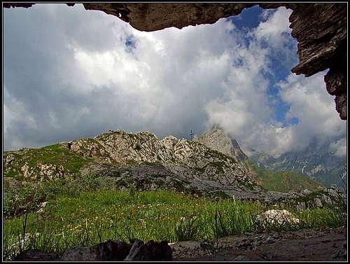
As Kleiner Pal / Pal Piccolo is not that high, distant views are mainly obscured by the neighbouring mountains. But they are also nice to be seen: On the west the wild massif of Hohe Warte / Monte Coglians attracts most of the views. Especially nice is the sharp cone of Cellon / Creta di Colinetta, which accompanies us during the whole ascent from the Austrian side. More towards the NW there's the rugged Gamskofel, then the deeply cut gorge of Mauthner Klamm and beyond it, towards the NE the massif of Polinik and its trabants. The crest from Polinik goes over a few minor summits towards the SE, where it attaches on the main crest of Carnic Alps. There the massif of sharp Hocheck / Creta di Timau rises. Nicely is seen its wild southern outpost - Gamspitz. Towards the SE is the But valley and beyond it the lower fore-mountains of Hohe Warte / Monte Coglians group.
View on Polinik
View on Cellon / Creta di Collinetta
View on Hocheck / Creta di Timau
Mauthner Klamm
Through the gorge, falling down from Ploecken Pass / Passo di Monte Croce towards the North (actually, it's the canyon of Anger Bach), a protected marked path goes, which is worth visiting for itself. Mauthner Klamm is claimed one of the most beautiful gorges of Kaernten. For visitors the bottom part is opened, the tour consists of two parts: the lower part is easy, for family hikes, the next part (called Klabautersteig) is a medium hard ferrata, where some expertise is needed. Altitude to do: 200 meters. The trailhead is in Mauthen, the parking place near Schwimmbad. Then the route goes by the water bed, there are many hanging bridges and tunnels in rocks. The whole tour lasts some 4 hours (30 min + 2 hours upwards, 1 hour 30 minutes downwards by Roemerweg - the ancient Roman path). It is possible also to exit the gorge on Ploecken Pass road - the best option is perhaps to prepare a bike up there and do a round tour.
Getting There
In memoriam...
Carnic Alps - Main Ridge (Eastern part)
For general overview, see the Carnic Alps group page and the Carnic Alps Main Ridge (East) subgroup page. All shorter ascents start on Ploecken Pass / Passo di Monte Croce, which can be from both sides reached by a good asphalt road. Other possible trailheads are more deep down in the valley of But or on the Austrian side on Hausalm, 1215 m, by the main road, north of the saddle. The Italian route (No. 401) starts just on the main parking place on the saddle. The ferrata has its trailhead a few meters on the northern side, where the road has already two branches (the western one in a tunnel, the eastern one on open air). There's a nice parking place, and also some more meters northwards, where the usual ascent from the Austrian side starts.
Routes Overview
On the Austrian path
To explore the caverns, take a battery with you
Normal Ascents and the Ferrata
1. Over the MG Nase (Maschinengewehrnase). Above the main road, north of the saddle, there was a stronghold in World War I, which today many historical paths reach. The shortest one is from the saddle, another trailhead is on the mainroad just below the hill and the third trailhead is down on Hausalm, 1228 m, from where the Museumweg brings you up. All this is just for tourists, who want to visit only a few remains from the big war, and not to ascend Kleiner Pal / Pal Piccolo itself. From MG Nase the path continues over the slopes towards the E and then finally more steeply towards the SE on the summit plateau. Before reaching it, many fortifications can be visited, and so of course on the plateu itself. Cca 620 m of altitude difference, 1 h 30 min, easy, on a few places steep hike-up, marked, requiring a safe step. Gear: poles and a battery for visiting caves.
2. From Ploecken Haus, 1215 m. It stands by the main road on Hausalm. We continue by the road towards the lower station of material cable car and continue by the marked path ("Landsturmweg") towards the SE. In many switchbacks it brings you on the plateau, where the upper station and a small private haus stands and in a few further minutes on top. 1h 30min, easy, marked, on a few places steep hike-up, requiring a safe step. Gear: poles and a battery for visiting caves.
3. Italian route (No. 401 - Traversata Carnica). From the saddle the path starts encircling the rocky western fore-summit of Kleiner Pal / Pal Piccolo. In some 20 minutes we reach a system of crags, where the climbing area is (Palestra di Roccia). On a nice day you will be able to observe climbers, hanging in those walls, while slowly gaining the altitude. One short passage on the path is secured with a steel rope, otherwise the ascent is easy. In the last part the ascent switches the direction towards the NE, over a small saddle enters the karstic valley on the summit plateau, and by the valley the private hut. From there right on the main summit. Cca 620m of altitude difference, 1h 30min, easy, marked, on a few places steep hike-up, requiring a safe step. Gear: poles and a battery for visiting caves.
*** 4. "Oberst-Gressel-Gedenkweg" - ferrata. From the saddle in a few minutes to the protected part of the route. Over two wall steps, then by a rib to the gorge and towards the right in an overhanged part of the wall. Through a short chimney and over the slabs to the exit. A hard, modern ferrata (1995), cca 400 m of climbing, 1 h 30 min. Gear: a complete ferrata set. You best descend by the above #1 or #3. *It looks that this ferrata has been dismantled, so the wall is now without protection devices!
Around the southern crags
5. Traversata Carnica. The famous path, crossing the whole main crest of Carnic Alps, goes also over Kleiner Pal / Pal Piccolo. In the part from the road pass parking place to the summit, it's identical with our #3 ascent. But from the summit of Kleiner Pal / Pal Piccolo the route continues towards the east. If we are not continuing on a long-distance trek, the options of going more towards the east from Kleiner Pal / Pal Piccolo are for making a longer round tour. So, we can reach Freikofel / Cuelat, 1757 m, and then descend by a marked path either to the north or to the south. From the saddle W of Freikofel / Cuelat, the path No. 401a goes down in the valley of But creek and a marked path also towards the Anger Bach valley, where it hits a mountain road. Also from the saddle E of Freikofel/Cuelat, Roessboden Toerl / Passo Cavallo, 1622 m, two paths descend in the two valleys. Towards the SW the path No. 410 goes, while the Austrian path again has no number. The broadest round tour would be continuing by Traversata Carnica all the way to Tischlwanger Toerl / Passo di Pal Grande (and 'take with you' also the summit of Groesser Pal / Pal Grande), 1760 m, and from there northwards into the end of Anger Bach valley. That descent is not marked (and even if not hard itself, quite unpleasant). Towards the SW another marked path descends even much more before Tischlwanger Toerl / Passo di Pal Grande, 1760 m. This is the path No. 402 and 402a, descending by the valley of Rio Gaier. From Tischlwanger Toerl / Passo di Pal Grande the Traversata Carnica continues into the massif of Creta di Timau.
In the Kleiner Pal / Pal Piccolo crags
Harder Climbs
In the crags of the southern side there are numerous popular routes. Their difficulty varies from 3 to 7b (on French gradation). Far the most popular route is called Spigolo de Infanti.
If you have more information, please post it!
Red Tape
By the path...
There are no limitations.
Camping
The ascent can be easilly done in half of a day (1-2 hours up, 1-2 hours down), except if opting for a broader round tour. But also these can be easilly done in one day. Private huts are only along the road over Ploecken Pass / Passo di Monte Croce. The hut on the summit plateau is private.
When To Climb?
In good conditions Kleiner Pal / Pal Piccolo can be climbed in any season. The only exception would be deep snow when there would be an avalanche danger. In snow you need ice pick and crampons, unless conditions are really ideal. For weather conditions, see the main Carnic Alps page!
Books & Maps
RKar na Karnijce. Gaberscik: Guida escursionistica alle Alpi Carniche. Studio64srl Edizioni, 2010 (7th edition), Genova. In Italian.
Guidebook and photomonography (in Slovenian): V. Pogačnik: Kar na Karnijce. Založba Narava, 2011.
You can see a detailed map (1:50.000) on-line on: http://www.austrianmap.at/, but the map embedded on this page is more detailed and offers more useful information for a hiker.
our Help Needed
Do you have any hader climb descriptions?
Do you have winter pictures from the mountain?
Can you write a chapter with more events from the World War I?
Children refers to the set of objects that logically fall under a given object. For example, the
Aconcagua mountain page is a child of the 'Aconcagua Group' and the 'Seven Summits.' The
Aconcagua mountain itself has many routes, photos, and trip reports as children.
Parents refers to a larger category under which an object falls. For example, theAconcagua mountain page has the 'Aconcagua Group' and the 'Seven Summits' asparents and is a parent itself to many routes, photos, and Trip Reports.

 11174 Hits
 84.27% Score
 18 Votes