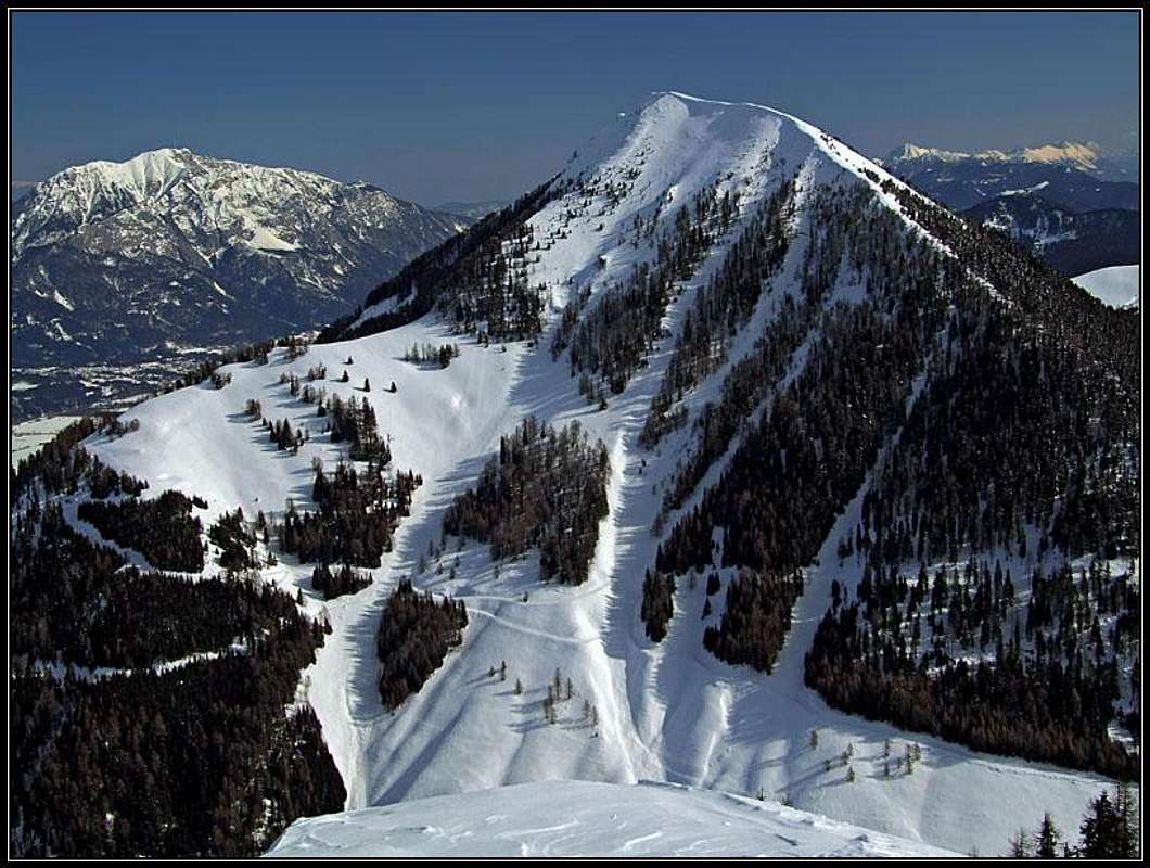
Ojstrnik from the summit of StarhandOjstrnik/Oisternig from the SEOjstrnik from west, from the...
What's New On This Page?
> Jan 22nd, 2019: Design corrections. > Dec 21st, 2014: Gozman chapter added. > Mar 13th, 2013: SP V3 design updated. > Dec 29th, 2009: Zahomec chapter added. > Jan 6th, 2005: Initial set up of the page.
Summits, described on this page
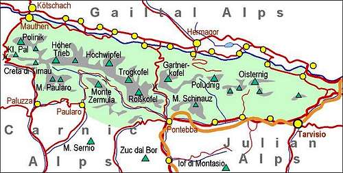
> Ojstrnik, 2052 m, > Zahomec / Monte Acomizza / Schoenwipfel, 1800 m, > Gozman, 1795 m.
Ojstrnik/Oisternig Gets Presented
Even if I'm an advocate of writing names of mountains on multi-lingual areas with all names, I shall in this case use only the Slovenian name. The other two names, the Italian Monte Osternig and German Oisternig are transcriptions with the later origin.
In addition to the main (western) summit, there is also a minor eastern summit, where a big cross stands.
Ojstrnik is the last high summit in the Carnic Alps Main Ridge, going from the west towards the east. Despite its name (in Slovenian language 'oster' means 'sharp') here only little is left of Carnic Alps rocky nature. Only the summit slopes are mixed rocky and grassy, already 200 meters below only grassy slopes are all around and below the altitude of some 1600 meters there are mainly broad forests.
The mountain is very popular. Firstly because of its panorama and secondly because of its easy access. Many forest roads and cart-roads, although closed for public traffic, reach the high regions of Ojstrnik, the highest one coming even to Feistrizer Alm / Bistriška planina, 1720 m. So primarily this summit is a nice hiking destination, in winter and early spring also a very nice tour skiing destination and I believe that many roads offer also many mountain-biking possibilities.
Some interesting places to visit will be mentioned in the next chapters. Here let me mention only Vorderberger Wildbach (Vorderberg Wild Creek), north of Ojstrnik mountain, which has in its lower part, just above the village of Vorderberg, a short, picturesque canyon. It looks that the trail which was built through the gorge, is now ruined, so the gorge can not be passed without canyoning equipment.
The second summit in this small group, which is worth visiting, is the grassy Zahomec / Monte Acomizza / Schoenwipfel, rising SE of Ojstrnik / Oisternig. It is lower, but because being even closer to Julian Alps, it also offers a great panorama. NW of its summit is Zahomška planina / Achomitzer Alm, where also a mountain road reaches. So in summer this area is also very popular for mountain biking. In winter almost all slopes are nice for skiing (difficulty: F on the SAC scale). On the W-SW ridge, just on the timberline, stands a cute St. Ubertus / Hubertus chapel.
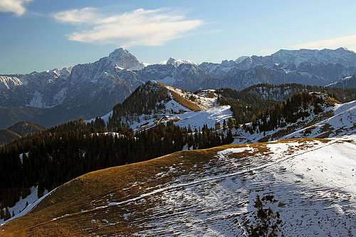
On Zahomska planina / Achomitzer Alp
Eastern Julian Alps
Sunset
Gozman, 1804 m
Marija Snežna - Maria Schnee
Similarly to the west-east oriented ridge of Ojstrnik and west-east oriented ridge of Zahomec / Monte Acomizza / Schoenwipfel, between them there is also the west-east oriented ridge of Gozman. Also this one is grassy and only a little rising above the neighbouring valleys. But also Gozman offers a very nice panorama. Being so close to both alpine meadows it's worth ascending it.
Nice ex shepherds paths, today converted into high mountain roads are connecting Feistritzer Alm / Bistriška planina and Achomitzer Alm / Zahomška planina. On both alpine meadows there are also private huts. Just in the mid way, on the eastern slopes of Gozman, a cute chapel stands. It is called Marija Snežna / Maria Schnee and was erected by people of Bistrica ob Zilji / Feistritz an der Gail.
The view from Marija Snežna - Maria Schnee
Feistritzer Alm Geo Point
It's hard to imagine, but Bistriška planina / Feistritzer Alm (meadow with many weekend huts), on the altitude 1722 m, was in devon, some 380 million years ago, a seabed. It was a warm, tropical sea, full of corals, crinoids, shells and algae. Their petrified remains are abundant on the gravel slopes above Bistriška planina and in paleozoic limestones along the path on thr summit of Ojstrnik.
Otherwise, the whole upper part of Ojstrnik is made of Devonian limestone. The lower parts of its northern slopes are even a bit older, made of grey, banded limestones from late Silurian and early Devonian. On the southern side, the rocks nature starts changing on Feistritzer Alm. Rubble and moraines are covering the bedrock, but that one is made of carboniferous shales and sandstones, stretching to Achomitzer Alm.
Northern (Austrian) trailheads are in Gailtal / Ziljska dolina. Driving towards the west we can reach villages of Feistritz and Vorderberg from Villach in some 18 or 27 kilometers. From Bistrica ob Zilji / Feistritz an der Gail, a good, but steep mountain road goes up to Bistriška planina / Feistritzer Alm, 1700 m. It is opened for public traffic, but when snow lies on it, even if it's cleaned, the ascent is very hard.
From the southern (Italian) side the best starting point is Valle di Ugovizza (valley), into which we drive from the Udine - Tarvisio - Villach highway from the village of Ugovizza / Ukve. This road is closed for public traffic on the altitude of 1210 m.
On the web, you can see a detailed map on: http://www.austrianmap.at/, but perhaps even more precise and illustrative is the map below - explore it!
A very recommendable classical map is: Tabacco 019: Alpi Giulie Occidentali Tarvisiano, 1:25.000.
Because of so many forest and cart-roads there is a great variety of possible ascents on Ojstrnik. Below are just some most convenient.
Summer routes
1. From the SW, from Valle di Ugovizza. From the parking place on 1200 m we go either northwards towards Lom (saddle) and then from just before it eastwards to Feistritzer Alm and the summit, or we go immediately eastwards to Sella Pleccia and then northwards to Feistritzer Alm and the summit. 3 h.
2. From the S, from Camporosso, 819 m, near Tarvisio, we follow the road and markings No. 508 towards the north till below the summit of M. Acomizza / Schoenwipfel, 1813 m, and further towards the north to Feistritzer Alm and the summit. 5 h.
Ascending Ojstrnik from the south
3. From the NE, from Feistritz, we follow all the time the forest road and markings No. 481 to Feistritzer Alm and then further on the summit. 5 h. Otherwise, from Feistritzer Alm you have only 1 h to the summit, which is the qickest and easiest route on Ojstrnik.
4. From the N, from Vorderberg we follow the forest road and markings No. 15 and 478 to Werbutzalm, above which we reach the NE ridge and by it (see #2) continue to the summit. 4-5 h.
5. The other option from Vorderberg is the western road, which goes above Vorderberger Wildbach (creek) and by Dolinzabach (creek) to Lom (saddle) in the main Carnic Alps crest and then as described in #1 to the summit. 5 h.
Because Ojstrnik has nice slopes on all sides, a few ski tours can be chosen, considering snow conditions. Often we can choose between the southern firn and the northern powder snow.
1. From Valle di Ugovizza, as described above in #1 summer ascent. Very nice, except the dense forest SW of the summit.
2. From the NE, from Feistritz as described above in #3 summer ascent. We don't need to go all the way to Feistritzer Alm, but can ascend the summit also directly from Untere Alm (and ski down there) - but that's steeper and harder.
3. From Lom saddle directly, or over the NW slopes. Perhaps this is the most beautiful ski tour on Ojstrnik. We reach Lom saddle either from the N or from the S, then we follow the cart road across the NW slope till a distinct ridge. On the NW slope we can find up to 600 altitude meters of powder snow, all the way down to Dolinza/Dolinca meadow.
4. Skiing down on Werbutzalm and further to Vorderberg. We probably will not ascend by this route, but if we ski from the summit by the E ridge to a broad saddle, there we find a steep ravine, which brings us down on the road to Werbutzalm. From the meadow, we continue northwards down through a light forest to a hut, where we hit a forest road. Then by the road down to Vorderberg. It is also possible to ski down by the rib, going down west of Werbutzalm.
5. From Val Bartolo. We go by the road on Bartolo saddle, then by the other road on Achomitzer Alm and further on Feistritzer Alm and on top. Long and not much skiing, except on the summit part.
Red Tape
There are no limitations.
When To Climb
Any time of the season.
Mountain Huts
Dolinca huts
Schoenwipfel Schutzhaus (on Achomitzer Alm / Zahomška planina), 1715 m. Opened in July and August, 10 + 5 beds, tel.: 04256/3163.
The ascent can be normally done in one day. In summer three huts are supporting outdoor activities around Ojstrnik:
Starhand hut on Lom saddle, 1460 m, private. Opened from mid May or start June till end of October, 7+15 beds, tel.: 04283/2004.
Books
Kar na KarnijceR. Gaberscik: Guida escursionistica alle Alpi Carniche. Studio64srl Edizioni, 2010 (7th edition), Genova. In Italian.
Guidebook and photomonography (in Slovenian): V. Pogačnik: Kar na Karnijce. Založba Narava, 2011.
Children refers to the set of objects that logically fall under a given object. For example, the
Aconcagua mountain page is a child of the 'Aconcagua Group' and the 'Seven Summits.' The
Aconcagua mountain itself has many routes, photos, and trip reports as children.
Parents refers to a larger category under which an object falls. For example, theAconcagua mountain page has the 'Aconcagua Group' and the 'Seven Summits' asparents and is a parent itself to many routes, photos, and Trip Reports.

 12567 Hits
 85.36% Score
 20 Votes


 On Zahomska planina / Achomitzer Alp
 Eastern Julian Alps
 Sunset
 The view from Marija Snežna - Maria Schnee
 Towards Hohe Tauern
 Eastern Julian Alps
 Western Julian Alps
 Carnic Alps
 Towards the NW
 Mangart group
 Dobrač
 Northern view
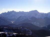 Viš and Montaž