
-
 9069 Hits
-
 88.6% Score
-
 27 Votes
|
|
Mountain/Rock |
|---|---|
|
|
46.57112°N / 13.06532°E |
|
|
Hiking, Mountaineering, Skiing |
|
|
Spring, Summer, Fall, Winter |
|
|
6703 ft / 2043 m |
|
|
What's new on this page?
- JUN 4th, 2019. A complete update (routes, pictures).
- JAN 10th, 2009. Initial page setup.
Mountains, described here

> Monte Dimon, 2043 m,
> Monte Paularo, 2043 m,
> Monte Neddis, 1990 m,
> Crete di Mezzodi, 1980 m,
> Val di Legna, 1708 m.
Intro
"Why posting two mountains on one page?", would certainly be your obvious first question. Well, they are like twins, similar rounded shape, close together, in summer accesed from the same alpine meadow. And even more - they have exactly the same altitude - 2043 meters.
I was waiting long to ascend one of them - Monte Dimon. Less attractive than the high, sharp peaks of Carnic Main Crest, but ideal for skiing, they were waiting me to find abundant time of Christmnas holidays, when I was ready to drive far around by many valleys to enjoy a ski tour of only 800 meters. But it was worthwile. Very worthwile! Finally, this twin mountain was one before the last missing mountain of Carnic Alps Main Ridge - eastern part for me to climb. Now, only Monte Schinauz is still resisting (2009) ...
Overview
Monte Paularo and Monte Dimon are the twin mountains, rising south of the main crest of Carnic Alps. So, theay are much different in nature from other mountains, which is due to the geological variety of Carnic Alps understandable. They are mostly rounded and grassy, allowing ascents from virtually all sides. As on all slopes there are pastures, many mountain roads and cart roads reach quite high altitudes. One of them ends only 150 meters below the summit of Monte Paularo. Both mountains are very nice for hiking, skiing and mountain biking. The view from their summits is opened towards the east, south and west, while on the north there are higher mountains of the main crest which are also very picturesque.
Geographical Outline
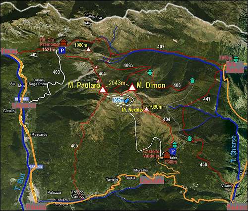 The sketch-map of the area.
On the west Monte Paularo and Monte Dimon massif is bordered by the valley of Torrente But. South on the foothills there is the town of Paluzza, towards the north Laipacco and Timau are worth to mention. These are all trailheads for western ascents. On the south Torrente Pontaiba and Rio Minischitte are separating the massif from Monte Tersadia. The saddle between both creeks is called Forcella di Lius. Over it a road connects Paluzza with Paularo on the east. On the Paluzza side on the valley slopes there's Ligosullo. The eastern border of the massif is Torrente Chiarso. North of the town of Paularo it soon forms a steep gorge, which separates our massif from Monte Zermula further on the east. There also a mountain road goes up on Passo del Cason di Lanza and further towards the east. Above the gorge, close to Casera Ramaz a side tibutary inflows Torrente Chiarso. This is Rio Cercevesa, flowing on the NE side of our massif, thus separating it from the main crest of Carnic Alps. Its sources are below Forcella Fontanafredda, 1876 m, the saddle, on which our massif is attached to the rest of the main crest.
So, Monte Paularo and Monte Dimon are a small massif, in the shape of a side ridge, coming down from the main Carnic Alps crest towards the SE, all the time keeping the altitude around 1800-2000 meters. Coming from the NW, from Forcella Fontanafredda, there are first a few ridge elevations (1995 m, 2020 m), then soon the summit of Monte Paularo, 2043 m, comes. On it the ridge branches. A weaker side branch goes down towards the SW, to Paluzza, while the stronger branch goes in a form of a bit sharper ridge towards the east on Monte Dimon, 2043 m. The distance between the two peaks is 1.25 km. From Monte Dimon the ridge continues towards the SE. It is rounded, easilly passable, appropriate also for skiing. On the other side of a small saddle, 1950 m, the first elevation is Monte Neddis, 1990 m. This summit is very popular in winter, because tour skiers usually don't continue on Monte Dimon. From it, a broad shoulder continues down and the ridge finally reaches the valley near Paularo. On some side ridges there are other, unimportant elevations, which also have names. Between Monte Paularo and Monte Dimon, on the S side, there is a small basin with a lake. Lago Dimon is popular hiking and biking destination in summer.
Summit View
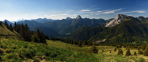
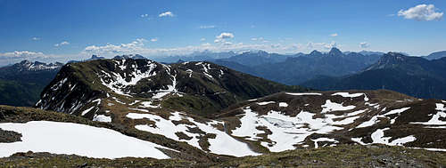
As Monte Paularo and Monte Dimon are standing south of the main Carnic Alps crest, the view from them is very fine. The most attractive are of course the highest mountains on the north, especially Monte Coglians / Hohe Warte. Towards the west the view goes to the highest mountains of Dolomites and on the SW there are Dolomiti d'Oltre Piave.
The view towards the south is also much opened. On the SE we are mostly attracted with the bold posture of Monte Sernio, which is close and seen from the very attractive side. Nice is also his "sister" Creta Grauzaria. On the SE and E are Julian Alps, among the high peaks the most attractive looks from here Montaž. And finally on the E and NE are the neighbouring Carnic Alps summits: Monte Zermula and Creta di Aip / Trogkofel.
Here are 4 pictures of the view from Monte Dimon:
 Towards the E Towards the E |
 Towards the NW Towards the NW |
 Towards the SE Towards the SE |
 M. Paularo/div> M. Paularo/div> |
Geology and Lago Dimon geosite
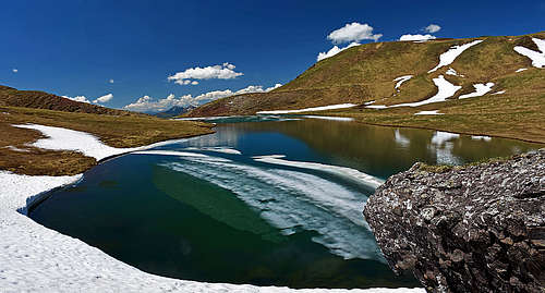
Because Monte Dimon is also geologically very interesting mountain, the high Lago Dimon (1840 m) is arranged as one of the geopoints of Furlania country. Already 300 million years ago the mountain was part of a paleozoic mountain range which existed before the Alps chain - The Hercynian Chain. But unlikely to other Carnic mountains of that chain, the Dimon geologic Formation is volcanic by origin (gray to green sandstone and shale, red and green slate, volcanic rocks), dating back to the Carboniferous era. Younger red Val Gardena sandstones are originating from the upper Permian era, but most of them are washed away by erosion. Still, the boundary between those two geological formations is nicely seen in the change of rock colours - from dark grey to red. Later some other rock layers were deposited, until finally, some 30 million years ago, the mountaineous area rised out of the sea again - together with all other Alps. Finally, around the lake the traces of last ice ages can be seen - at the end, also the lake itself is the result of glaciation. Since some 18.000 years ago the whole area had been covered with ice, which started to retreat only some 15.000 years ago. The ancient glacial valley of Monte Dimon hosted a lake which was initially at least one third bigger than it is today.
Getting There
For a broader picture of the area, see the main page of Carnic Alps.
From the north, from Austria, the main road comes over Ploeckenpass / Passo di Monte Croce Carnico and comes down in the valley of Torrente But. The majority of visitors however comes from the south. Paluzza and Paularo can be reached from Tolmezzo, driving towards the north. But you are probably more interested of the information about the mountain roads.
The road, connecting Paluzza and Paularo is usually cleaned also in winter. If not entirely, almost certainly till Ligosullo, so come from the west, from Paluzza. From Ligosullo, 944 m, a good mountain road goes up to Albergo Castel Valdaier, 1340 m. Also that road looks usually cleaned. We came start of January, when there was really a lot of snow, and the road was cleaned. The road further towards Lago Dimon is in winter and spring not cleaned. Also in summer it is closed for public traffic (even if on June 1st, 2019 I saw no prohibition sign). So, for skiing it would mean long crossings of slopes, in summer the road would be a great opportunity for mountain biking. Above Castello Valdaier you can drive a bit more up towards the Valdaier alpine pasture (Casera Valdaier, 1470 m), where just some 10 m below the meadow there are 2-3 parking places.
The road from Paularo towards Passo del Cason di Lanza is in winter not cleaned. See tourist information in Paularo for more details. So for tour skiing from the east and north, the approaches are very long.
From Laipacco, in the But valley, a narrow mountain road goes up ro Rif. Casera Pramosio, 1521 m. That road is in summer opened for public traffic, in winter it is most certainly not cleaned.
Routes Overview
From the map sketch it can be seen that Monte Paularo and Monte Dimon can be reached by marked paths from virtually all sides. Actually, there are even more paths, because military built a dense network during the World War I. Many of these routes can be done also in winter and spring by skis, but I have no detailed information.
1. The NW approach
It's the shortest one and very much in use. Only good 500 meters of altitude must be overcome from Rif. Casera Pramosio. The path (No. 404) first reaches Forcella Fontanafredda (detouring Crete di Mezzodi by W slopes) and then continues by the ridge (a bit up and down) on top of Monte Paularo. Italian grading of difficulty is E (Escursionisti = Hikers), 3 hours.
2. By the SW ridge
This long approach comes directly up from Paluzza. From the village Zenodis or from the end of the road, which comes from Paluzza, we have by an easy path (No. 405) some 1600 or 1100 meters of altitude to overcome.
3. From Albergo Castello Valdaier
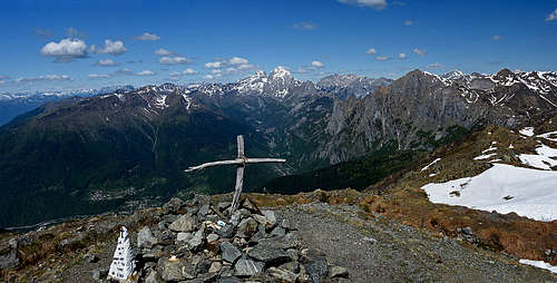
Due to good starting point and southern orientation, both ascents from Castello Valdaier, so by the SE ridge and by the mountain road to Lago Dimon are very popular. The SE ridge to Monte Neddis is also a very popular ski tour.
 On the SE ridge On the SE ridge |
 Below M. Neddis Below M. Neddis |
 On M. Neddis On M. Neddis |


From the parking place we first go a few minutes up by the road to Casera Valdaier, then the marked path No. 404 deters left from the road. In winter we can also ascend directly by meadows, by ex ski terrains; ski lifts are now removed. In both cases we make sure not to go too much towards the right, encircling the mountain is not needed. So above Casera Valdaier we go directly up and reach the ridge close to Cima Val di Legnan, 1709 m (communication tower there). Then the broad and comfortably flat ridge begins. It's very panoramic and brings us to the summit slopes of Monte Neddis, 1990 m. The last 200 meters are again moderately steep and nowhere exposed. From Monte Neddis it is some 30 minutes more to the summit of Monte Dimon. We first descend some 50 meters and then the rounded ridge continues to the highest point. 3 hours from the parking place, easy (T2 on the Swiss Hiking Scale), easy and very nice is also the ski tour (on the SAC scale PD- on Monte Dimon and F+ till Monte Neddis)!
The second ascent option goes simply by the mountain road. It is not steep, so very appropriate for mountain bikers. It reaches just above Lago Dimon and a bit further the ex shepherds huts (Casera Montelago). From there we have only some 30 min more to each of the two summits - Monte Dimon is to the right, Monte Paularo to the left.

And there is also the third, quite nice option. From Castel Valdaier we can drive up and leave our car just before Casera Valdaier, 1470 m. From there we can continue by a marked mountain road, which crosses the eastern slopes of Monte Neddis. On the eastern ridges of Monte Neddis and Monte Dimon there are alpine pastures, for which the road was built. Then after Casera Montute di Mezzo we just keep left and reach the notch just before Monte Dimon by the path No. 456.
4. Monte Dimon - Monte Paularo connection
The ridge between the two summits gets quite narrow (the W ridge of Monte Dimon) and also lowers considerably - to some 1915 m. So, coming from Monte Dimon, it's best to descend by its southern slopes and then cross by a good military path towards Casera Montelago. Then you just continue towards the W-NW on Monte Paularo. Some 45 min altogether.
5. From Paularo
These ascents are also long and they join the above #3 approach on the SE ridge.
6. From Casera Ramaz
The approaches from Val Cercevesa are using mostly the shepherds paths, so also the marked paths are not aiming directly towards the both summits. But there are many unmarked shortcuts possible. Concerning skiing, it must be said that even if these mountains are rounded and mostly grassy, not all slopes are appropriate for skiing. Some are steep as well, others are eroded. And also the nice side ridges towards the east end below in a deep gorge.
Red Tape
There are no limitations.
Huts and Camping
Ascents can be done in one day, even if some are quite long. Here are the most useful official huts:
- Rifugio Casera Pramosio, 1521 m. Opened in summer. Can be reached by a mountain road, a "bed and breakfast" type hut with 20 places. Tel. 0433/775757
- Albergo Castel Valdaier, 1340 m. Can be reached by a mountain road, a hotel on a nice place where the trailheads are.
When to Ascend?
Any time of a season. 
Books

Guidebook and photomonography (in Slovenian): V. Pogačnik: Kar na Karnijce. Založba Narava, 2011.
Your Help Needed
Can you in detail describe routes, other than the above by the SE ridge?
- Do you know any other recommendable ski tour?
- Any mountain biking experience?
- Any interesting pictures of the two mountains from other sides?