
-
 9539 Hits
-
 83.69% Score
-
 17 Votes
|
|
Mountain/Rock |
|---|---|
|
|
46.59709°N / 13.09785°E |
|
|
Hiking, Skiing |
|
|
Spring, Summer, Fall, Winter |
|
|
6611 ft / 2015 m |
|
|
Overview

From the nearby Cima Val di Puartis
On the way to Findenigkofel / Monte Lodin
Summits, described here
> Findenigkofe, 2016,
> Waidegger Hoehe, 1960 m,
> Cima Val di Puartis / Puartis, 1914 m,
> Feldkofel, 1864 m,
> Leitenkogel, 1845 m,
> Noelblinger Hoehe, 1760 m.
General
Findenigkofel / Monte Lodin is a ridge mountain, which is a nice hiking goal because it stands a bit more out of the main Carnic crest than the neighbouring mountains. Otherwise there is nothing so special in it - a very steep, grassy southern slope, a short, partly rocky northern slope and the two ridges meeting on the culmination point. Still, the neighbourhood is beautiful. Nice high alpine meadows, attractive especially in autumn and spring, slopes, appropriate for tour skiing, broad panorama ...
So, Findenigkofel / Monte Lodin is first of all a hiking mountain. Along the whole Carnic Main Crest goes the famous Karnischer Hoehenweg / Traversata Carnica - a multi-day, long-distance hike. Next, in good conditions Findenigkofel / Monte Lodin can also be done as a ski tour. If conditions are not so good, you can ski down virtually from any of the neighbouring bumps or mountains, such as Waidegger Hoehe or Leitenkogel. The area around Findenigkofel / Monte Lodin is also very appropriate for mountain biking. Many mountain roads and good path, originating from ex military roads can bring you quite high, the total elevation gain from the valley of Gail / Zilja could exceed 1200 meters. And the last, but not least matter of interest - the area is well known by producing good cheese - the Gailtaler Almkaese ('Gail valley alpine cheese). For those, interested in history - along the main ridge many remains from the World War I are still seen. Already two days after the Italian declaration of war, the mountain was occupied by Italian troops and only after several unsuccessful attacks the Austrians could recapture it in mid-September 1915. By the end of the war, the mountain then remained under Austrian control (Wikipedia).
In the main Carnic crest, the first saddle NW of Findenigkofel / Monte Lodin is Passo Lodinut / Noelbling Pass, 1817 m. More towards the W there's Passo Pecol di Chiaula / Zoellnertoerl, 1797 m, which can be considered the border between Findenigkofel / Monte Lodin and Hoher Trieb / Cuestalta. Towards the E of the main summit, there's first Lodintoerl, ca. 1865 m, after which a gentle crest is waving in quite some distance towards the broad Passo di Meledis / Straniger Sattel, 1613 m.
Close to the highest summit there are some more peaks to mention. South-east of the main summit there are in the main crest a few more rocky bumps, one of them has a name Cima Val di Puartis / Puartis, 1927 m. It's already all on the Italian territory. Towards the north in the vicinity of Findenigkofel / Monte Lodin a strong side ridge deters from the main Carnic Alps crest. It branches soon in three ridges. The nothwestern branch culminates on Waidegger Horn, 1962 m, after which two branches go down dowards Gail/Zilja valley. In the western branch, the last higher elevation is Noelblinger Hoehe, 1760 m. The northeastern main branch reaches first a highpoint on Leitenkogel, 1845 m, the next bump in the ridge, Feldkofel, is even a bit higher, 1864 m, then the ridge descends further down. All these summits are nice, easy hiking goals and ski tour goals.
Around Findenigkofel / Monte Lodin there are many nice and broad alpine meadows. On the southern, Italian side, these are (from the E towards W): Casera Meledis Bassa, Casera Meledis Alta, Casera Ramaz Bassa, Casera Ramaz Alta, Casera Lodinut Basssa, Casera Lodin, Casera Lodin Alta and Casera Pecol di Chiaula Alta. On the northern, Austrian side, the nearby alpine meadows are (from the E towards W): Straniger Alm, Waidegger Alm, Achornachalm, Ochsenalm and Zollner Alm.
Geology
Around Findenigkofel only Paleozoic rocks can be found. The summit ridge is mostly built of older Carboniferous slate and sandstone / greywacke. But on the NE (Austrian) slopes already many different limestones can be found, mostly of dark, grey and reddish color. They are older, from all ages of Devonian and even from Silurian, so 420-440 million years old. That is why the north face of Findenigkofel has been included as one of the geo-points of Carnic Alps Geoparc. The broad area east of the summit, towards Straniger Alm is again built of younger, Upper Carboniferous slate and sandstones.
Summit Panorama
 Grauzaria-Sernio group |
 Towards the NW |
 Reisskofel |
Getting There
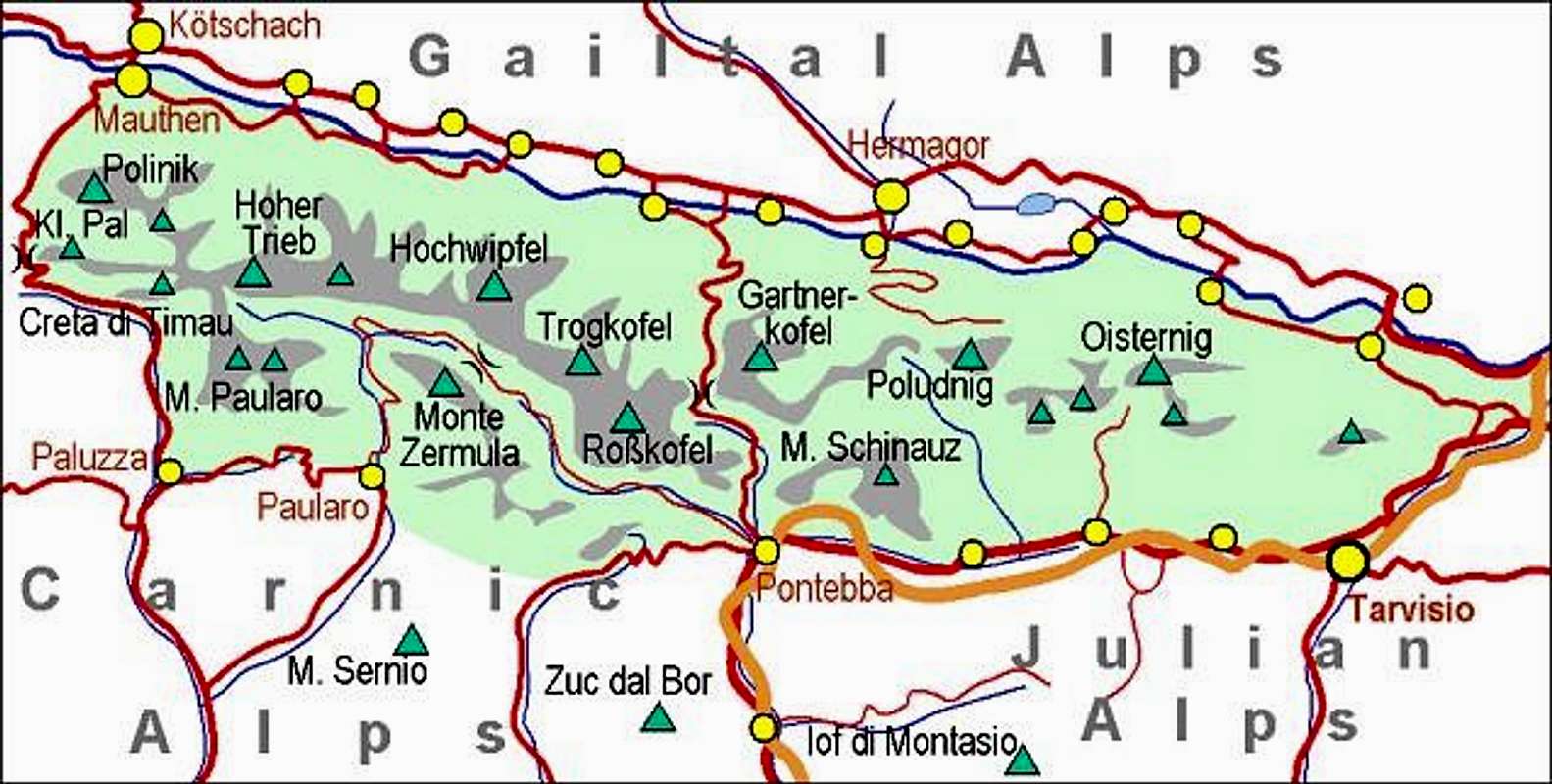 |
Carnic Alps - Main Ridge (Eastern part). Findenigkofel is the summit between Hoher Trieb and Hochwipfel. For general overview, see the Carnic Alps group page and the Carnic Alps Main Ridge (East) subgroup page. |
Gail/Zilja valley on the north can be reached from Villach (highway), driving towards the west.
Paularo can be reached from Tolmezzo (highway), driving towards the north and then deterring north-east in Val Incarojo.
Pontebba lies by the Udine-Villach highway.
Findenigkofel / Monte Lodin summit can be reached from three main directions:
- From Straniger Alm, 1492 m. The meadow can be reached by a narrow, but still solid mountain road, starting in Stranig in Gail / Zilja valley. It is opened for public traffic from June 1st till end of September. From Straniger Alm the mountain road continues to Waidegger Alm, 1745 m. I nowhere saw any signs prohibiting the drive, but it is a bit untasty to use noisy vehicles so high on nice mountains. This is the eastern approach.
- The second approach from the Gail / Zilja valley brings you on Zollner Alm, where Dr. Steinwendner hut stands, 1720 m. From there towards the east a mountain road continues to Ochsen Alm, 1700 m, but it is perhaps better to start the tour by Dr. Steinwendner hut. The mountain road starts in Weidenburg, south of Dellach. The road is opened for public traffic from mid June till end of September. This is the western approach.
- The third approach comes from the south, from below Passo del Cason di Lanza, 1552 m, precisely, at Casera Ramaz, 1030 m (also bus station there), which is reachable by a nice mountain road, which encircles Monte Zermula, thus connecting the towns of Pontebba and Paularo. The road is usually opened from end of April till end of October.
Routes Overview
The summit of Findenigkofel / Monte Lodin can be reached by three marked approaches.
|
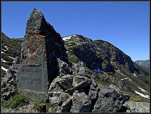
1. From the east. From Straniger Alm, 1492 m, you go by the path No. 403 (or by the road) on the saddle between the main Carnic crest and Waidegger Hoehe. Continue westwards by Karnischer Hoehenweg and below Lodintoerl turn left up towards the main crest. You pass the monument from World War I, soon reach the summit ridge and along the trenches from the WW1 the highest point. 1 hour 45 minutes from Straniger Alm. 2. From the west. From Dr. Steinwendner hut, 1720 m, go by Karnischer Hoehenweg towards the east. It brings you just below Noelbling Pass / Passo Lodinut, 1817 m. Go on the saddle and follow the main ridge to the top. 1 hour. 3. From the south. From the Italian side you can reach the main crest by many paths, but the shortest one (3 h) for a one-day tour is the marked path No. 457, which starts on Casera Ramaz, 1057 m (or, on the bus station below, on 1030 m). It brings you in 1 h 45 min on Casera Lodin alta, from where you can do a round tour - either towards the NE on Lodintoerl, by the main ridge on top and down via Noelbling Pass / Passo Lodinut and Casera Lodinut Alta, or vice versa (1 h 15 min more for the summital part). On this, southern side of the mountain, there are many more trails, most of them from the World War I, when the summit ridge was heavily fortified. In addition to those, there are also many old shepherds paths, connecting the alpine meadows. |
4. Waidegger Hoehe from the south. This grassy summit can be easily ascended by the trail No. 44 from the broad saddle south of it (1810 m). 30 minutes from the saddle (left across the slopes runs also a variant, suitable for mountain bikers). From the summit, marked trail continues far towards the NW, almost to the summit of Noelblinger Hoehe. Just before it, on Ochsenbachsalm, it turns right down, where the cart-road descends in many turns into the Gail / Zilja valley. That's of course in reverse direction also the possibility on a long ascent to the upper area.
5. Similar is the situation on Leitenkogel and Feldkofel. From the broad saddle 1810 m south of Waidegger Hoehe, a marked trail ascends towards the NE first on Leitenkogel and then along the ridge almost til Feldkofel. Just before it, the marked trail goes right down the slopes and via Unterbuchacher Alm down into the Gail / Zilja valley.
Findenigkofel / Monte Lodin can of course also be traversed on a multi-day hike along the main Carnic Alps crest. If coming from the west, you can start a day etappe also on Casera Promosio, cross first Hohe Trieb / Cuestalta, 2198 m, and continue eastwards on Findenigkofel / Monte Lodin. You can see a detailed map (1:50.000) on-line on: http://www.austrianmap.at/.
 On the ascent |
 Eastern view |
 The view on M. Sernio |
Red Tape
There are no limitations.
Huts And Camping

Straniger Alm

Straniger Alm
On the surrounding alpine meadows there are many private huts, where you can eat and drink. The three bigger mountain huts, where you can also sleep are:
Zollner hut on Straniger Alm, 1492 m. Managed by Sagmeister family, tel.: +43(4285)243. The hut has a few rooms, prices vary from 45€ to 75€.
Dr. Steinwendner hut, 1720 m. It has 28 places and 6 places in winter room. Opened from mid June till end of September. Tel.: 0043/4718/625 (in the valley: 0043/664/1060014).
Rif. Pietro Fabiani, 1539 m. Opened from mid June till mid September. Tel.: 329-3009876. E-mail: rifugiofabiani@gmail.com. The hut can be reached from the road in 1 hour 30 minutes (paths no. 407 and 454a).
When To Climb?

Winter on Straniger Alm
Findenigkofel / Monte Lodin can be ascended any time of the year. Very beautiful is autumn, but also spring and seasons when conditions for ski touring are good.
Books

Guidebook and photomonography (in Slovenian): V. Pogačnik: Kar na Karnijce. Založba Narava, 2011.