
-
 4996 Hits
-
 80.49% Score
-
 12 Votes
|
|
Mountain/Rock |
|---|---|
|
|
38.88280°N / 110.8137°W |
|
|
Emery |
|
|
Hiking, Mountaineering, Scrambling |
|
|
Spring, Summer, Fall, Winter |
|
|
7406 ft / 2257 m |
|
|
Overview
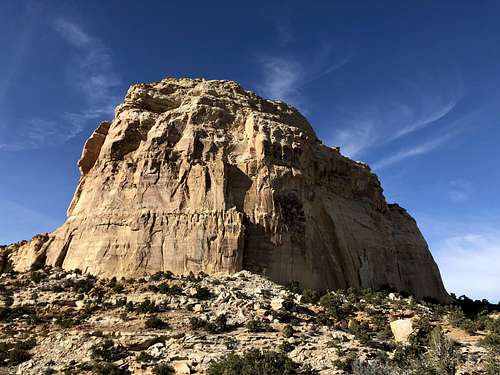 Chimney Rock
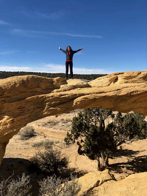 Dutchman's Arch
Chimney Rock is a massive looking summit and it does appear intimidating but as mentioned above the outing is pretty short and the technical difficulty was much easier than I expected. It can be seen from Interstate 70, especially Ghost Rock View Area.
There is plenty of exploration nearby, e.g. Dutchman Arch, which is near the trailhead. There are also some Indian petroglyphs towards Locomotive Point.
Difficulty: some resources 5.3, some 5.6 (the climbing section is short)
Length: 2-3 hrs
Getting There
The approach from Dutchman Arch takes about one hour. Initially, the Chimney Rock is not seen, but the later half of the hike you get clear views of the massive formation. There is an old road closed to traffic pretty much all the way to the base of Chimney Rock. I also recorded the approach on Gaia application.
Option 1: Hike from Interstate 70, park at Ghost Rock view and rest area (I have not hiked this way, but your objective Chimney Rock, should be seen on most of your approach). The advantage is that you do not need 4 WD vehicle, and you do not have to navigate the multitude of dirt road in the area.Option 2: Take exit 131 from Interstate 70, it is about 30 miles west of Green River (last service for gas). The road (Temple Road) goes west on the south side of interstate in the western direction. Set up odometer here - at 3.8 miles go right towards Head of Sinbad. Keep staying on the main road (some smaller roads will be branching off).
One mile past this junction another road comes in, stay on the main road.
Go for another 3.4 miles to a signed junction for Dutchman Arch - go right.
You will cross under the freeway about 0.5 miles.
Right after the freeway go left follow a fence for a short distance and then turn north.
0.2 miles from the highway is a junction, go left and stop at Dutchman Arch - pretty impressive landmark.
You can either hike from here, or drive 0.5 miles to the TH - there is an old road closed to vehicles which you will follow.
![Summit Chimney Rock]() Summit Chimney Rock
Summit Chimney Rock![Short crack]() Short crackI followed Road Trip Ryan instructions and map - great resource and also recorded the approach on Gaia application for my personal reference.
Short crackI followed Road Trip Ryan instructions and map - great resource and also recorded the approach on Gaia application for my personal reference.
Route
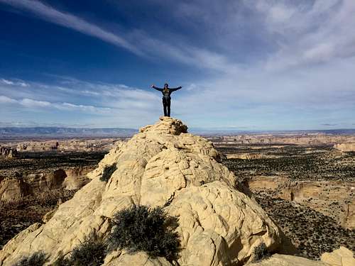 Summit Chimney Rock
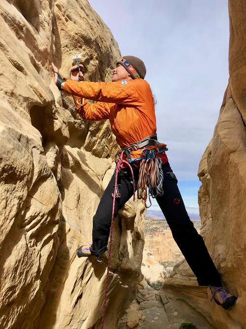 Short crack
Follow the road until a fork - this fork is hard to see and GPS was very useful here. We found the 2nd road then and continued the approach on this road. The climb starts on the northeast side of the formation.
We continued ascent along the base of the Chimney rock until we saw a nice looking crack/gully going up. We took this first gully although later on the descent we took another an easier path down. Someone has left there his/hers trekking poles there.
Once up a gully we found the narrow red ledge and followed along towards the south side of Chimney Rock. The ledge is mostly easy walking, occasionally with some exposure. Eventually, you will seen an obvious notch. You can either do a unprotected slab (5.3) climb here or about 2-3 meters further west there a nice crack to go up to. The crack is more difficult, but protects well. I used camalot #1 and # 0.75.
Climbing higher up is much easier, slabby and I placed two slings for a protection through hourglass. The anchor is visible at a small tree.
Leave your rope here and and hike/scramble to the top of the formation. This section is relatively easy and rope is no more needed.
Descent: we did one rappel from the tree, it is short and walked or down climbed the route.
Red Tape
There is no red tape. Climbing, hiking, camping, visiting the area is free.
When to Climb
Summers can be hot. Otherwise any season is good as long as it is dry. Bring plenty of water.
Camping
There is basic camping at the trailhead and by Dutchman Arch. Locomotive Point area has more campsites. No toilet facilities and no water.