
|
|
Mountain/Rock |
|---|---|
|
|
36.20590°N / 114.5548°W |
|
|
Clark |
|
|
Bouldering |
|
|
Spring, Fall, Winter |
|
|
3300 ft / 1006 m |
|
|
Overview
The Cleopatra-Hamblin paleovolcano formed 11-15 million years ago (Ma), in the late Miocene epoch – a time of mountain-building in the Basin and Range Province of the western US. This stratovolcano exists today as rugged erosional remnants. Deep canyons are incised through the tuffs, lava flows and breccias, exposing radial dikes and creating ragged summits.The mountains discussed in this article are on the west side of the Overton arm of Lake Mead, Nevada, just east of Las Vegas. The goals of the article are to relate the original structure of the volcano to the present-day topography; and to hint at the climbing and hiking opportunities that exist in this vastly eroded land. Enough information is given to start the hikes and find the key waypoints, but I’d prefer to leave a bit of mystery. Some license is taken, in that two coeval volcano and two sedimentary viewpoints – with impressive scenery – are used to explore the geology; these latter hikes give some of the best views into the core of the volcano, as one traverses the sedimentary basement and intrusive interior.
It is hard to classify this page – it’s really about one or two mountains that no longer exist. There are several named “ranges” that cross the area, but the geology is tumultuous, that the range designations have no geographic or geologic consistency. I’m extremely disinclined to create a mountain and route page for every brown lump in my view; in this area, the canyons are as significant as the mountains, and a separate discussion for each denies the common bonds. I’m not obsessed with SP points, so I’ll call it one mountain and leave it at that, primarily so people can sign a “summit log” and provide updated information. (If you climb the two peaks already in SP -- Northshore or Redstone -- please go to those pages to sign the logs.)
In the following discussion, “Cleopatra-Hamblin paleovolcano” will be shortened to “Cleo volcano”. The Lake Mead National Recreation Area is referred to as “LMNRA”.
Getting There
All The hikes and viewpoints described herein are accessed by the Northshore Road in LMNRA. Additional driving on high-clearance or 4WD roads is required for some hikes.In Las Vegas, take the i-15 exit onto Lake Mead Boulevard. From the exit, travel east, over the pass between Frenchman and Sunrise mountains, to the fee booth for Lake Mead NRA. From the fee booth, travel a short distance SE to a “T” (this T is about 17 miles east of the i-15 exit onto Lake Mead Blvd). Turn left at the T for Northshore Road. Each hike description below repeats part of these directions, and gives the stopping or turning points on Northshore Road.
Red Tape
Obey the restrictions in the literature given out at the fee booth. This area is adminstered by BLM, and there is a general charge of $5/car, good for 5 days, to enter the area. Interagency passes are also accepted.Camping
Primitive camping is available off the gravel roads, subject to BLM restrictions. There is little or no water, and the summers here are deathly hot.Geology and Hikes
Geology
The Mesozoic Era (251 Ma to 65.5 Ma) saw deposition of sediments across the region. Many of these sediments were sub-aerial dunes, as might be formed in Death Valley or on Cape Cod in modern times. Eventually these dunes produced many of the brightly-colored, cross-bedded sandstones seen today in Red Rock, NV and the north Muddy Mountains. Near the end of the Mesozoic, huge compressive forces were generated to the west, as earth plates collided and were partly subducted under the western edge of North American continent. The result of this compression was the Sevier Orogeny, in which older Paleozoic rocks (principally limestones and dolostones) were thrust eastward over the Mesozoic sediments. Locally, Muddy Mountain thrust sheet is an immense pile of carbonate rocks over the younger sandstones (the sandstones are visible in Hidden Valley NW of Muddy Peak).
In the Tertiary, the compression was replaced by a period with the opposite condition – extension – as the entire Basin and Range area was pulled apart. This extension was accommodated by development of fault-block mountains, and coincident sedimentation as the up-lifted horsts of the fault-block mountains eroded. Starting in the Miocene epoch, several volcanic centers developed on the west side of the present Lake Mead. About 15 to 16 million years ago, plutonic rocks began intruding beneath what is now a band stretching from south of Hamblin Mountain, to the Cathedral Mountains, nearly 20 km away. The magma from these plutons fueled the formation of at least two stratocvolcanoes; the present-day Cleo volcano, and a coeval (approximately the same age), less-defined volcanic center to the SW. The Cleopatra volcano is now most obvious in the rocks that stretch from Cathedral Cove westward, across the Redstone Peaks, to Hamblin Mountain; the other volcano is manifest locally as the sharp peaks of Booth Pinnacle and Pyramid.
The Cleo volcano – by far the best-studied – consists of an alternation of ~andesite flows, breccias (formed from pre-existing volcanic rocks and new ash), and tuff-like deposits. The layering is obvious as one walks down Cleopatra Wash. These sloped flows are intruded by andesitic to basaltic dikes, which weather out of the softer tuff-like rocks to stand in high relief. However, the harder dikes are also filled with cooling joints, so even though they initially stand out from the host rock, they have often crumbled to low walls no more than a meter high.
Complicating the geologic picture, several large fault zones were active all through the Cenozoic mountain-building. These fault zones run mainly SSW to NNE, and served to split the volcanoes asunder and smear out the geology. The Cleopatra volcano was smeared along a left-lateral fault zone (specifically, the Hamblin Bay Fault). The two biggest remnants of the stratovolcano are now centered near Cleopatra wash in the east, and Hamblin Mountain, some 20 km to the west. The one-time magmas that fed the volcano are now exposed as plutonic rocks, in between the two major pieces of the volcano.
Below is a schematic of the evolution of the Cleo volcano, starting about 13 Ma (Tingley, 2001). This set of "cartoons" is best correlated with the geologic map that follows.
 Schematic Development of Cleo |
Below is an except from the USGS geologic map of the Cleopatra-Hamblin area. The full report is available at the USGS Publications Warehouse. The locations of peaks and canyon entries – described in the hiking section below -- are also shown on the map as blue dots.
 Geologic Map for Cleo Volcano |
Below are some important rock type designations on the map above, and in some of the following photos. (Please use the detailed unit identifications on the map; the colors described below are just approximations.)
Qa and Q1a: This is just alluvium, less than 1 Ma old, derived locally by erosion of all the rock types described below. Q1a is older than Qa, and makes up much of the gravels and sands one trods in the NE washes.
Tvc: Units of the Cleo volcano; from 13.1 Ma in the lower units, to 11 Ma in the upper. Composed of andesites, various volcanic/sedimentary breccias and tuff-like rocks, and radial dikes varying in composition from andesite to basalt. This is the dominant deep magenta in the map above; the yellow lines on the magenta signify the radial dikes, which presumably radiate out from the eruptive center.
Tvh: Units of the Hamblin volcano; coeval with the Cleo volcano, likely part of the same complex, just translated by faulting.
Ti: The intrusive igneous complex thought to have fed the Cleo volcano, locally exposed andesites and dacites, more coarsely crystalline than rocks of Tvc.
Tbwd and Tbwdt: Dacite flows and tuffaceous units from a stratovolcano thought to be coeval with the Cleo volcano; 12.5 to 14.2 Ma. Grayish-purple to reddish-brown. Locally manifest in Pyramid Peak and Booth Pinnacle. Pink, stippled and un-stippled on map above.
Twr: Wilson Ridge Pluton. Mainly quartz diorite, texturally diverse, with many cross-cutting mafic dikes, ~13.5 Ma. The sections near Boulder Wash date at ~12.5 Ma, but the relatively “young” age may reflect long-term 300C resetting of the ages. Plain light magenta in the map above (not patterned).
Thr: Rainbow Gardens Member (of Horse Spring Formation). These are the rocks that cap the Ja at Sentinel Peak. Locally consists of a basal conglomerate, and a limestone unit; from 28 to 18 Ma.
Ja: Jurassic Aztec sandstone. Usually reddish, aeolian in origin (e.g. wind-blown dunes).
TRm: Moenkopi Formation. Mudstone, carbonates, sandstone, and gypsiferous sedimentary rocks. Lower-Middle Triassic. Aquamarine in the map above.
Pkt: Permian Kaibab and Toroweap; locally consists of cherty limestones, grayish with a tan tinge in places. The ridges and knobs of chert are very frictional, and cut through skin easily. Blue in the map above.
Hikes and Geological Viewpoints
The hikes here are described briefly, with references to the full SP pages, when possible. The aim is to supply enough information to get you started, with a few photos to point out the geological features. Be warned, all of these are cool weather hikes, some are quite exhausting, and some require navigation skills. The following 100k topographic map shows all the hikes described in this section.
 100k Topo for Cleo Volcano Hikes |
Most hikes/viewpoints have corresponding 24k maps with marked waypoints. The waypoints are mentioned by name in the text for each hike, but the numeric listing of all waypoints is at the end of this section.
Cleopatra and Kendall Washes
Perhaps the easiest hike through the core of the ancient volcano, is the trek down Cleopatra Wash.
 24k Topo Map for Cleopatra/Kendall Washes |
The get to the start of the hike, drive to the fee booth on the NW side of the LMNRA. Continue SE to the junction with Northshore Road, take the left (NE), and continue on Northshore Road ~27 miles, to a subtle right turn on the unmarked Boathouse Cove Road. (This turn is at 36.26392, -114.48254 WGS84; at the turn, the Northshore Road is trending almost due N, and the dirt road cuts sharply back ESE.) Take the dirt road 2.9 miles to the start of the Cleopatra Wash hike, the Cleo1 waypoint in the list below. At this point, the road turns 90 degrees to the right; park before the turn. The vehicle needed depends a lot on the recent washouts and blading history; high clearance is recommended as a minimum (though I have taken a 7.3” clearance Subaru down this road). The stretch ½ mile before the parking area is occasionally very rough, with irregular bedrock exposed.
The hike down Cleopatra wash is quite colorful, with some very interesting exposures of cross-cutting dikes and fracture fills.
 Quasi-Colorful Rocks |  Breccia Boulder |  Radial Dike in Tuff |  Layering in Volcanics |
 Oxidation of Tuff/Breccia | 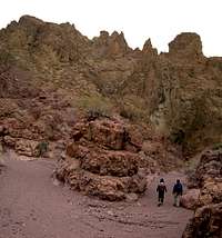 Pinnacles in Tuff |  Narrows Canyon |
The standard route is down Cleopatra wash to the lake, then back, retracing your steps. There are at least 3 chockstones/dryfalls blocking the way to the lake; at least two have easy drops on the S side, but the last one gets your attention, and you may wish to end the hike here. Alternatively, you can back-track a bit, then climb up the side of the canyon and to the east, around main channel and the chockstone, and thence down to the lake. In my younger, stupider days, I downclimbed this last chockstone, but my compatriots took the bypass.
The hike is more interesting if you choose to come back through Kendall Wash, by crossing N down at lake level -- or slightly to the W, as shown on the map above. Be warned that Kendall Wash has a few marginal class 3 sections, and navigation is more difficult, as at one point you will want to get back to your starting point by leaving the wash and cutting SW. The return trip, uphill in Kendall wash, requires that you aim for waypoint Kend2, then turn due W up a small drainage to Kend3, then leave the drainage and head over a pass, downhill to Ken1, which is once more in Cleopatra wash. Kendall Wash has some of the best exposed radial dike fragments.
 Exposed Dike | 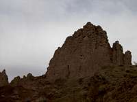 Another Dike |  Slot in Kendall |
 Glassy Dike |  Breccia Exposed! |
Cathedral Peaks
These mountains need require no more than class 2 climbing. The real difficulty is the navigation across the many washes. It is very easy to get lost in this area; until you can see the spire on the NW side of the main ridge, all the terrain looks about the same, and the washes are deep enough to block the view. The spire is actually low class 4 from the S side, a bit blind for descent.
 24k Topo Map for Cathedral Peaks |
(The northern track is preferred; the spire is just SW of the “C” in “Cathedral” on the map.)
The start of the hike is reached from the same gravel road described above for the Cleopatra Wash hike; however one need drive only ~0.5 miles down the road, to the Cat1 waypoint. Cat2 is simply a point to aim for; Cat3 is where one can leave the wash and climb left (NE) up the ridge, approaching the spire. The true highpoint is Cat4, which sits atop a huge cliff in the cruddy volcanic rock. This view below (to the SW) [picture SW] shows destinations for several other hikes described on this page; most of the visible rock consists of mixed Tvc (andesite and breccia flows), with radial dikes visible as sharp ridges.
 Locate this Spire |  Climbing Spire |  View W, Geologic Units |
Manganese Peak and the Tuff Pinnacles
The name “Manganese Mountain” is not on USGS maps; the peak was locally named because of the proximity to Manganese Wash, but actually Manganese Wash does not abut the mountain.
 24k Topo Map for Manganese Peak and Pinnacles |
The start of the this hike is also on the Boathouse Cove Road, as described in the Cleopatra Wash and Cathedral Peak hikes (in fact, the map below shows the “Cleo1” benchmark at the start of the Cleopatra Wash hike). From the Cleo1 waypoint, drive or walk SSW on the gravel road, to the Mn1 waypoint. If you have driven, park the car here, assuming you wish to do the loop. Contnue walking on the road to the wash indicated by waypoint Mn2. and turn SSE, traveling ~1 mile down the wash. At first there is a set of steep cliffs to the NE; as you approach waypoint Mn3, the ridge on the NE side descends almost to the wash. Mount the ridge by heading NE at Mn3, then turn and travel almost due N to the highpoint. Generally, one is best staying near the ridgeline, but there will be some interesting class 2 to mild class 3 terrain.
 View S from Manganese Peak |  Pinnacles N of Peak |
Take your time and remember this volcanic rock crumbles easily. At the summit, note the tuff pinnacles to the N; each pinnacle is actually formed from the ragged, differential erosion of the volcanic layers; the layering dips steeply to the east in that area, and can be seen in the photo at right above. To descend, initially travel N from the top, then find the ridge that heads NNW, NNE, to waypoint Mn4 (there are several pinnacles and steep highpoints on this ridge). At Mn4, you can descend back to Mn1; or if you feel adventuresome and confident on very steep cruddy rock, you can explore the pinnacles to the east. The pinnacles provide some awesome views to radial dikes, but for the most part are composed of cruddy, crumbly breccias and tuff-like rocks.
 Pinnacles with Radial Dike |  Climbing a Pinnacle |
Sentinel
This is one of the toughest hikes in the area, and is also the most scenic and rewarding. Though the top of the peak is actually composed of Tertiary limestones, the views over the plutonic and volcanic rocks are sweeping and awesome. I learned of this hike from Nick N, who gave me valuable pointers.
 24k Topo Map for Sentinel |
The hike begins off Northshore Road. From the fee booth on E , on the NW side of LMNRA, travel SE until you reach the “T” at Northshore Road. Turn left onto Northshore Road, and travel generally E for ~19.4 miles. Park where convenient, and walk to waypoint Sen1.
Travel roughly SE, over a few washes, till reaching Sen2 in a deeper wash. Now travel S and SSW up to a pass on the Pinto Ridge. At the pass, there is a striking view of the Pinto Valley to the SW, over Ja and Ti, to the Wilson Pluton rocks (Twr). From the pass, travel ~S down the steep wash, at first over open rocky terrain. About 0.2 miles before Sen3, at ~2100’ elevation, you will come across a big chockstone blocking the route. Climb up to the left (E), then down to avoid the chockstone. At Sen3, head generally E across the Pinto Valley; unfortunately, you will have to cross several small steep washes. Head for Sen4, then turn ~S, and navigate through the many turns in the valleys, as shown on the gps route on the map. Soon you will break through the Ja to the limestones. The view E shows the basement sedimentary rocks, and the feeder plutonics (Ti) as well as the dominant volcanics. Now head ~WSW over the very steep limestone terrain to the summit. You can descend back the way you came, or can head to the SW then WNW down a valley, to Sen5. Sen5 is at the top of a big chockstone/dryfall; at this point, head R (N then NE) through a notch, out of the chockstone valley, toward Sen6.
 S into Pinto Valley |  View W to Peak |  NE with Geologic Units |
 View W near Thr Saddle on Sentinel |
Booth Pinnacle and Pyramid
These peaks appear very impressive and almost technical, when seen from Northshore Peaks or Sentinel. Yet they are class 2 climbs (though one has to be cautious on the rotten volcanic rock), and the hardest challenge is in finding the correct valley from Boathouse Cove Road. “Booth Pinnacle” is not a name on the USGS map; the peak was informally named in honor of Howard Booth, a local outdoor enthusiast and conservationist.
To get to the start of the hike, follow the directions for reaching the unmarked Boathouse Cove Road in the description of the Cleopatra-Kendall Wash hike. Take the Boathouse Cove Road south for ~6.4 miles to the parking spot at waypoint bp1 (see map below). The latter part of this road may be quite rough, depending on the recent history of blading, and 4WD/HC is recommended.
 24k Topo Map for Booth and Pyramid |
 Booth and Pyramid from Sentinel |
From bp1, head roughly SW to waypoint bp2. The latter point is near a fork in the washes; you want to continue slightly N of due W, up the valley on the N side of Booth and Pyramid; you do NOT want to make the common mistake of heading S and SE down to the lake! The hills immediately SW of the bp1 are full of volcanic clays, which can be very slick after a rain, and there are many shallow, yet maze-like gullies to confuse the hiker. From bp2, continue W up the valley to bp3; at this point, start heading ~SW up the slope, then cut S, to arrive high on the western side of Booth. From there, it is a pleasant rocky ridge walk to the summit. You can then continue W across the saddle, to the summit of Pyramid, with one caution: there is a sharp drop-off on the west side of Booth, on crumbly volcanic rock. It is worthwhile to look for the safe way around this obstacle, rather than blindly plummet over the cliffs. From the top of pyramid, a valley on the N side heads ~NNE down to bp4.
 Clayey Terrain near Start; Slippery When Wet! | 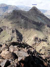 Pyramid from Booth |  Don't Stumble |
 Pyramid from Booth |
 Booth and Lake Mead from Pyramid |
 Lake Mead and (L to R)Arch, Guardian, and Boulder Mts,from Pyramid |
Redstone Peaks
As of 12/30/2007, there are SP entries for East Redstone and Redstone. There are more peaks to the west and southwest, with registers bearing the names “Mystery Cairn Peak” (the huge cairn is an old survey point) and “Vista Peak”. All summits are within 1.5 km, and a moderately in-shape hiker should be able to climb all four in a day. The route is mostly class 2, but much of the rock is crumbly. This mini-range is another fragment of the Cleo volcano (Tvc).
 N from East Redstone |  Redstone from Mystery Cairn |
Northshore Peak
This is not a volcanic peak, but rather is composed of Pkt (Permian Toroweap-Kaibab) limestones. However, the summit provides excellent views S into the heart of the paleovolcano. As of 01/23/2008, There is a summitpost page describing the first part of the standard Northshore Peak loop.
 Hamblin Mt. W of Northshore |  SE and S from Northshore, Units Labeled |
Hamblin Mountain
Hamblin Mountain is the extreme western portion of the paleovolcano, separated by 20 km from the Cleopatra Cove volcanics, thanks to left-lateral displacement along the Hamblin Bay fault zone. This is a relatively easy hike, with minor class 2 on occasionally rough volcanic boulders.
 24k Topo Map for Hamblin Mountain |
The hike starts off the Northshore Road, at waypoint Ham1; there is parking a bit farther up the hill, on the N side of the road. The starting waypoint is ~14.8 miles down Northshore Road, from the “T” east of the fee booth.
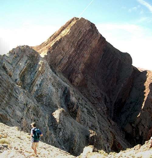
From Ham1, travel ESE and SE up Cottonwood Wash, past the “springs” (which may be manifest as a dryfall with a lone moderate-sized cottonwood), then head S at Ham2, and wind SW up a ridge to Ham3. From Ham3, there is a good view of Hamblin Mountain (photo below), and the route is fairly obvious. The top of the mountain gives good views down the Pinto Valley (photo below).
 View down Pinto Valley |  Volcanic Pile of Hamblin |
Boulder Peak
This hike ends on the northern flank of the Mt. Wilson (AZ) pluton, which is not part of the Cleo volcano; however, the hike crosses the Ti units (the intrusive feeder of the Cleo Volcano), and provides sweeping views back perpendicular to the fault lines, over the characteristic basement rocks. For information on the beginning of the hike, see the SP entry on The Guardian. By far the hardest part of the hike is the navigation into the Pinto Valley.
 24k Topo Map for Boulder Peak |
At bld1, climb SW out of the broad Boulder Wash, into a smaller wash that trends SW. At bld2, begin climbing out of the smaller wash, moving more SSW, toward bld3. the hike never need be more than class 2. If you encounter harder terrain, go around it (usually to the R). Now head S toward bld4, which –surprise, surprise! – is not the peak. Head SW and SSW across several peaklets, and one significant saddle, past bld5 to the true summit at bld6. If you wish to return down a different ridge, take a left at bld5, fllow the ridge almost N, then turn left at bld7 to avoid the cliffs.
 View NE to Sentinel, Ti Units Exposed |  View N from Boulder, Showing Units |
Note this is a long hike -- from 12 miles RT for the short approach (using the Pinto Ridge cross-over described for Guardian), to 18 miles RT for the Cottonwood Wash approach.
Waypoints for Hikes
Latitude and Longitude in Decimal Degrees; All relative to WGS84!
Booth-Pyramid
Bp1, 36.19668, -114.49149
Bp2, 36.19201, -114.49689
Bp3, 36.19176, -114.52912
Bp4, 36.19296, -114.53539
Boulder
Bld1, 36.19019, -114.57151
Bld2, 36.18917, -114.57271
Bld3, 36.18494, -114.5744
Bld4, 36.17916, -114.57286
Bld5, 36.17393, -114.57896
Bld6, 36.17205, -114.5803
Bld7, 36.18025, -114.57876
Cathedral
Cat1, 36.25856, -114.47581
Cat2, 36.26774, -114.45087
Cat3, 36.27000, -114.44174
Cat4, 36.27025, -114.42776
Cleo-Kendall
Cleo1, 36.23755, -114.46554
Kend1, 36.22864, -114.44729
Kend2, 36.23546, -114.44173
Kend3, 36.23545, -114.44542
Hamblin
Ham1, 36.20939, -114.65816
Ham2, 36.19868, -114.63944
Ham3, 36.19261, -114.64247
Manganese
Mn1, 36.23121, -114.47052
Mn2, 36.2186, -114.47695
Mn3, 36.20638, -114.46852
Mn4, 36.22629, -114.46607
Sentinel
Sen1, 36.22728, -114.58555
Sen2, 36.22009, -114.57941
Sen3, 36.20857, -114.57909
Sen4, 36.21254, -114.5476
Sen5, 36.20648, -114.56246
Sen6, 36.20741, -114.56132
References
Anderson, R.E. (1973) Large-Magnitude Late Tertiary Strike-Slip Faulting North of Lake Mead, Nevada. USGS Prof. Paper 794. (available online at the USGS Publications Warehouse.)Beard, L.S. et al. (2007) Preliminary Geologic Map of the Lake Mead 30’ x 60’ Quadrangle, Clark County, Nevada, and Mohave County, Arizona. USGS Open-File Report 2007-1010. (available online at the USGS Publications Warehouse.)
Tingley, J.V. et al. (2001) Geologic Tours in the Los Vegas Area (Expanded Edition). Nevada Bureau of Mines and Geology Special Publication 16. ISBN-1-888035-07-2. (p 70 gives a brief discussion of the Cleo volcano; provides a good, easy-to-understand background for the geohistory of the area.)
Wawrzyniec, T.F. et al. (2001) Paleomagnetic data bearing on style of Miocene deformation in the Lake Mead area, southern Nevada, J. Structural Geol. V23, 1255-1279.
Links
Jim Boone's Cleopatra HikeJim Boone's Jimbilnan Wilderness Page