

-
 31230 Hits
-
 89.39% Score
-
 29 Votes
|
|
List |
|---|---|
|
|
Overview
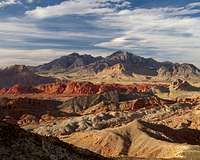
The Desert Peaks Section Peaks List consists of peaks compiled by the Desert Peaks Section of the Angeles Chapter of the Sierra Club in order to promote interest in the scenic desert ranges of the Southwest. The DPS is the oldest peak climbing section of the Sierra Club, formed by Chester Versteeg informally in 1941, and later officially in 1945. The original 1941 list contained seven peaks and remained unchanged until 1947. The list has since grown over the years until reaching its current state of 99 peaks, the latest addition being Muddy Peak in 2003. Of the 99 current peaks, two thirds are located in the deserts of California, with the rest located across Nevada, Arizona, southern Utah, and northwestern Mexico.
The original seven peaks on the DPS Peaks List were New York Butte (Chester Versteeg’s first desert peak), White Mountain Peak, Waucoba Mountain, Telescope Peak, Cerro Gordo Peak (removed and replaced with Pleasant Point in 1952), Coso Peak (removed for one year in 1947, for five years in 1956, and again permanently in 1973 due to difficult access within China Lake Naval Weapons Center), and Maturango Peak (also removed for one year in 1947 and for five years in 1956, though it remains on the list since 1961).
Seven of the current peaks have been designated as Emblem Peaks (Montgomery Peak, Mount Inyo, Telescope Peak, Rabbit Peak, Charleston Peak, Signal Peak, and Picacho del Diablo). Each Emblem Peak is identified in the table below with all caps. Coincidentally, one of the peaks on this list was the very first mountain ever represented on Summitpost with an informational page and that is Baboquivari Peak.
The official DPS list publication is available here, and Peakbagger.com provides a useful list page including a map and prominence information.
 |  |  |  |  |  |
DPS Peaks List
| DPS Number | Peak | Elevation | Clean Prominence | Latitude | Longitude | DPS Region | Quad | Class |
|---|---|---|---|---|---|---|---|---|
| 1.1 | Mount Patterson | 11,673 | 4,153 | 38.4366 | -119.3053 | Trans-Sierra - Mono and Inyo Counties | Mount Patterson | 1 |
| 1.2 | Glass Mountain | 11,160 | 3,180 | 37.7664 | -118.7040 | Trans-Sierra - Mono and Inyo Counties | Glass Mountain | 1 |
| 1.3 | Boundary Peak | 13,140 | 253 | 37.8461 | -118.3512 | Trans-Sierra - Mono and Inyo Counties | Boundary Peak | 2 |
| 1.4 | MONTGOMERY PEAK | 13,441 | 1,266 | 37.8382 | -118.3570 | Trans-Sierra - Mono and Inyo Counties | Boundary Peak | 2 |
| 1.5 | Mount Dubois | 13,559 | 2,319 | 37.7834 | -118.3432 | Trans-Sierra - Mono and Inyo Counties | Boundary Peak | 2 |
| 1.6 | White Mountain Peak | 14,246 | 7,196 | 37.6341 | -118.2558 | Trans-Sierra - Mono and Inyo Counties | White Mtn Peak | 1 |
| 1.7 | Waucoba Mountain | 11,123 | 3,923 | 37.0219 | -118.0077 | Trans-Sierra - Mono and Inyo Counties | Waucoba Mtn | 2 |
| 1.8 | MOUNT INYO | 10,975 | 975 | 36.7352 | -117.9857 | Trans-Sierra - Mono and Inyo Counties | New York Butte | 2 |
| 1.9 | Keynot Peak | 11,101 | 3,030 | 36.7076 | -117.9626 | Trans-Sierra - Mono and Inyo Counties | New York Butte | 2 |
| 1.10 | New York Butte | 10,668 | 1,148 | 36.6479 | -117.9326 | Trans-Sierra - Mono and Inyo Counties | New York Butte | 1 |
| 1.11 | Pleasant Point | 9,690 | 1,170 | 36.5707 | -117.8130 | Trans-Sierra - Mono and Inyo Counties | Cerro Gordo Peak | 1 |
| 1.12 | Nelson Range | 7,696 | 1,656 | 36.5565 | -117.6559 | Trans-Sierra - Mono and Inyo Counties | Nelson Range | 2 |
| 1.13 | Maturango Peak | 8,839 | 3,639 | 36.1200 | -117.4955 | Trans-Sierra - Mono and Inyo Counties | Maturango Peak | 2 |
| 1.14 | Argus Peak | 6,562 | 1,642 | 35.8522 | -117.4459 | Trans-Sierra - Mono and Inyo Counties | Trona West | 1 |
| 2.1 | Last Chance Mountain | 8,456 | 2,376 | 37.2804 | -117.6997 | Death Valley - Inyo County | Last Chance Mtn | 1 |
| 2.2 | Sandy Point | 7,062 | 1,622 | 37.1511 | -117.6186 | Death Valley - Inyo County | Sand Spring | 1 |
| 2.3 | Dry Mountain | 8,674 | 3,594 | 36.9090 | -117.5979 | Death Valley - Inyo County | Dry Mountain | 2 |
| 2.4 | Tin Mountain | 8,953 | 3,993 | 36.8867 | -117.4561 | Death Valley - Inyo County | Tin Mountain | 2 |
| 2.5 | Panamint Butte | 6,584 | 504 | 36.4339 | -117.3560 | Death Valley - Inyo County | Panamint Butte | 2 |
| 2.6 | Tucki Mountain | 6,726 | 1,846 | 36.4998 | -117.1302 | Death Valley - Inyo County | Emigrant Canyon | 1 |
| 2.7 | TELESCOPE PEAK | 11,048 | 6,168 | 36.1699 | -117.0892 | Death Valley - Inyo County | Telescope Peak | 1 |
| 2.8 | Sentinel Peak | 9,634 | 1,554 | 36.0965 | -117.0777 | Death Valley - Inyo County | Panamint | 1 |
| 2.9 | Porter Peak | 9,101 | 501 | 36.0499 | -117.0564 | Death Valley - Inyo County | Panamint | 1 |
| 2.10 | Manly Peak | 7,196 | 2,537 | 35.9150 | -117.1169 | Death Valley - Inyo County | Manly Peak | 1 |
| 2.11 | Needle Peak | 5,803 | 1,653 | 35.8863 | -117.0286 | Death Valley - Inyo County | Manly Peak | 2 |
| 2.12 | Grapevine Peak | 8,738 | 4,562 | 36.9653 | -117.1499 | Death Valley - Inyo County | Grapevine Peak | 1 |
| 2.13 | Mount Palmer | 7,958 | 718 | 36.9069 | -117.1331 | Death Valley - Inyo County | Grapevine Peak | 2 |
| 2.14 | Corkscrew Peak | 5,804 | 644 | 36.7707 | -117.0043 | Death Valley - Inyo County | Thimble Peak | 2 |
| 2.15 | Pyramid Peak | 6,703 | 3,703 | 36.3918 | -116.6122 | Death Valley - Inyo County | East of Echo Canyon | 2 |
| 2.16 | Smith Mountain | 5,913 | 1,593 | 36.0181 | -116.6891 | Death Valley - Inyo County | Gold Valley | 1 |
| 2.17 | Eagle Mountain (N) | 3,806 | 1,666 | 36.2113 | -116.3564 | Death Valley - Inyo County | Eagle Mtn | 3 |
| 2.18 | Brown Peak | 4,947 | 1,684 | 36.1152 | -116.3858 | Death Valley - Inyo County | Deadman Pass | 2 |
| 2.19 | Stewart Point | 5,265 | 2,378 | 36.1662 | -116.2081 | Death Valley - Inyo County | Stewart Valley | 2 |
| 2.20 | Pahrump Point | 5,740 | 344 | 36.0990 | -116.1399 | Death Valley - Inyo County | Twelvemile Spring | 2 |
| 2.21 | Nopah Point | 6,394 | 3,572 | 36.0064 | -116.0807 | Death Valley - Inyo County | Nopah Peak | 2 |
| 2.22 | Canyon Point | 5,890 | 1,090 | 36.5490 | -117.3806 | Death Valley - Inyo County | Harris Hill | 1 |
| 3.1 | Avawatz Mountain | 6,154 | 3,294 | 35.5127 | -116.3316 | San Bernardino County | Sheep Creek Spring | 1 |
| 3.2 | Kingston Peak | 7,336 | 3,727 | 35.7267 | -115.9156 | San Bernardino County | Kingston Peak | 2 |
| 3.3 | Clark Mountain | 7,907 | 4,232 | 35.5257 | -115.5887 | San Bernardino County | Clark Mtn | 3 |
| 3.4 | New York Mountains | 7,532 | 3,333 | 35.2588 | -115.3113 | San Bernardino County | Ivanpah | 3 |
| 3.5 | Old Dad Mountain | 4,252 | 1,218 | 35.1012 | -115.8610 | San Bernardino County | Old Dad Mtn | 2 |
| 3.6 | Mitchell Point | 7,048 | 913 | 34.9783 | -115.5379 | San Bernardino County | Fountain Peak | 2 |
| 3.7 | Edgar Peak | 7,162 | 2,208 | 34.9555 | -115.5363 | San Bernardino County | Fountain Peak | 2 |
| 3.8 | Granite Mountain (N) | 6,762 | 2,792 | 34.7937 | -115.6954 | San Bernardino County | Bighorn Basin | 2 |
| 3.9 | East Ord Mountain | 6,168 | 1,488 | 34.6392 | -116.7626 | San Bernardino County | Ord Mountain | 1 |
| 3.10 | Old Woman Mountain | 5,325 | 2,733 | 34.5733 | -115.2354 | San Bernardino County | Old Woman Statue | 2 |
| 3.11 | Sheep Hole Mountains | 4,593 | 2,198 | 34.2267 | -115.6920 | San Bernardino County | Dale Lake | 2 |
| 3.12 | Stepladder Mountains | 2,927 | 713 | 34.5886 | -114.8734 | San Bernardino County | Stepladder Mountains | 2 |
| 3.13 | Chemehuevi Peak | 3,694 | 1,774 | 34.5522 | -114.5627 | San Bernardino County | Chemehuevi Peak | 2 |
| 3.14 | Turtle Mountains | 4,298 | 2,658 | 34.2611 | -114.8276 | San Bernardino County | Mopah Peaks | 2 |
| 3.15 | Mopah Point | 3,530 | 960 | 34.3104 | -114.7651 | San Bernardino County | Mopah Peaks | 3 |
| 3.16 | Whipple Mountains | 4,130 | 2,790 | 34.3146 | -114.4111 | San Bernardino County | Whipple Mtns SW | 1 |
| 4.1 | Martinez Mountain | 6,562 | 1,722 | 33.5543 | -116.3454 | Riverside County | Martinez Mtn | 2 |
| 4.2 | RABBIT PEAK | 6,640 | 1,200 | 33.4336 | -116.2394 | Riverside County | Rabbit Peak | 2 |
| 4.3 | Rosa Point | 5,000 | 280 | 33.3617 | -116.1685 | Riverside County | Fonts Point | 2 |
| 4.4 | Pinto Mountain | 3,983 | 1,253 | 33.9537 | -115.7994 | Riverside County | Pinto Mountain | 1 |
| 4.5 | Eagle Mountain (S) | 5,350 | 2,230 | 33.7441 | -115.7399 | Riverside County | Hayfield | 1 |
| 4.6 | Orocopia Mountains | 3,815 | 2,095 | 33.5692 | -115.7797 | Riverside County | Orocopia Canyon | 1 |
| 4.7 | Black Butte | 4,504 | 2,844 | 33.5614 | -115.3449 | Riverside County | Pilot Mountain | 1 |
| 4.8 | Chuckwalla Mountains | 3,446 | 1,426 | 33.4549 | -115.1682 | Riverside County | Chuckwalla Spring | 2 |
| 4.9 | Spectre Point | 4,482 | 2,546 | 34.0261 | -115.4046 | Riverside County | Cadiz Valley SW | 2 |
| 4.10 | Granite Mountain (S) | 4,331 | 3,314 | 33.9701 | -115.0729 | Riverside County | Palen Pass | 2 |
| 4.11 | Palen Mountains | 3,848 | 2,339 | 33.8339 | -115.0388 | Riverside County | Palen Mountains | 2 |
| 4.12 | Big Maria Mountains | 3,381 | 2,298 | 33.8679 | -114.6691 | Riverside County | Big Maria Mts SW | 1 |
| 5.1 | Indianhead | 3,960 | 760 | 33.2926 | -116.4304 | San Diego and Imperial Counties | Borrego Palm Canyon | 2 |
| 5.2 | Sombrero Peak | 4,229 | 329 | 32.8323 | -116.2914 | San Diego and Imperial Counties | Sombrero Peak | 2 |
| 5.3 | Jacumba Mountain | 4,512 | 1,272 | 32.6977 | -116.1646 | San Diego and Imperial Counties | Jacumba | 1 |
| 5.4 | Picacho Peak | 1,920 | 1,097 | 32.9725 | -114.6639 | San Diego and Imperial Counties | Picacho Peak | 6 |
| 6.1 | Ruby Dome | 11,387 | 4,793 | 40.6217 | -115.4754 | Nevada | Ruby Dome | 2 |
| 6.2 | Wheeler Peak | 13,063 | 7,563 | 38.9857 | -114.3138 | Nevada | Wheeler Peak | 1 |
| 6.3 | Arc Dome | 11,773 | 5,213 | 38.8327 | -117.3530 | Nevada | Arc Dome | 1 |
| 6.4 | Mount Jefferson | 11,941 | 5,861 | 38.7520 | -116.9268 | Nevada | Mount Jefferson | 1 |
| 6.5 | Hayford Peak | 9,912 | 5,392 | 36.6578 | -115.2007 | Nevada | Hayford Peak | 1 |
| 6.6 | Mount Stirling | 8,218 | 1,017 | 36.4532 | -115.9686 | Nevada | Mt Stirling | 1 |
| 6.7 | CHARLESTON PEAK | 11,915 | 8,240 | 36.2716 | -115.6956 | Nevada | Charleston Peak | 1 |
| 6.8 | Mummy Mountain | 11,528 | 800 | 36.2993 | -115.6496 | Nevada | Charleston Peak | 2 |
| 6.9 | Potosi Mountain | 8,514 | 3,012 | 35.9655 | -115.5015 | Nevada | Potosi | 2 |
| 6.10 | McCullough Mountain | 7,026 | 2,170 | 35.6029 | -115.1799 | Nevada | McCullough Mountain | 1 |
| 6.11 | Spirit Mountain | 5,639 | 2,879 | 35.2749 | -114.7235 | Nevada | Spirit Mtn | 2 |
| 6.12 | Moapa Peak | 6,471 | 1,671 | 36.8585 | -114.4516 | Nevada | Moapa Peak | 3 |
| 6.13 | Virgin Peak | 8,071 | 3,183 | 36.6028 | -114.1123 | Nevada | Virgin Peak | 1 |
| 6.14 | Bridge Mountain | 6,988 | 689 | 36.1320 | -115.5016 | Nevada | La Madre Spring | 3 |
| 6.15 | Muddy Peak | 5,387 | 876 | 36.2983 | -114.6934 | Nevada | Muddy Peak | 3 |
| 7.1 | North Guardian Angel | 7,395 | 675 | 37.3162 | -113.0583 | Utah | The Guardian Angels | 4 |
| 7.2 | South Guardian Angel | 7,140 | 1,205 | 37.2954 | -113.0599 | Utah | The Guardian Angels | 4 |
| 7.3 | Navajo Mountain | 10,346 | 4,226 | 37.0343 | -110.8696 | Utah | Navajo Begay | 1 |
| 8.1 | Mount Tipton | 7,148 | 3,628 | 35.5388 | -114.1927 | Arizona | Mt Tipton | 2 |
| 8.2 | Humphreys Peak | 12,633 | 6,039 | 35.3464 | -111.6780 | Arizona | Humphreys Peak | 1 |
| 8.3 | Superstition Peak | 5,057 | 1,817 | 33.4110 | -111.4007 | Arizona | Goldfield | 2 |
| 8.4 | Weavers Needle | 4,553 | 993 | 33.4331 | -111.3707 | Arizona | Weavers Needle | 4 |
| 8.5 | SIGNAL PEAK | 4,877 | 3,477 | 33.3592 | -114.0829 | Arizona | Palm Canyon | 2 |
| 8.6 | Castle Dome Peak | 3,788 | 2,088 | 33.0847 | -114.1434 | Arizona | Castle Dome Peak | 3 |
| 8.7 | Kino Peak | 3,197 | 1,537 | 32.1096 | -112.9554 | Arizona | Kino Peak | 3 |
| 8.8 | Mount Ajo | 4,808 | 2,698 | 32.0268 | -112.6905 | Arizona | Mount Ajo | 2 |
| 8.9 | Baboquivari Peak | 7,734 | 4,194 | 31.7711 | -111.5959 | Arizona | Baboquivari Peak | 4 |
| 9.1 | Cerro Pescadores | 3,543 | 3,346 | 32.3675 | -115.4461 | Mexico | Sierra Cucapa | 2 |
| 9.2 | Pico Risco | 4,987 | 32.1339 | -115.8107 | Mexico | Arroyo del Sauz | 3 | |
| 9.3 | PICACHO DEL DIABLO | 10,171 | 6,956 | 30.9924 | -115.3751 | Mexico | Santa Cruz | 3 |
| 9.4 | Cerro Pinacate | 3,957 | 3,150 | 31.7725 | -113.4991 | Mexico | Volcan el Elegante | 1 |
 |  |  |  |  |  |
Resources
The data in this list is based on USGS Topographic Maps, Summitpost Pages, and these links:
The Desert Peaks Section’s homepage and official peak list
Peakbagger page on the DPS by Greg Slayden
Climber.org page on the DPS including GPS files
Alphabetical List
| Peak | DPS Number | Elevation | Clean Prominence | Latitude | Longitude | DPS Region | Quad | Class |
|---|---|---|---|---|---|---|---|---|
| Mount Ajo | 8.8 | 4,808 | 2,698 | 32.0268 | -112.6905 | Arizona | Mount Ajo | 2 |
| Arc Dome | 6.3 | 11,773 | 5,213 | 38.8327 | -117.3530 | Nevada | Arc Dome | 1 |
| Argus Peak | 1.14 | 6,562 | 1,642 | 35.8522 | -117.4459 | Trans-Sierra - Mono and Inyo Counties | Trona West | 1 |
| Avawatz Mountain | 3.1 | 6,154 | 3,294 | 35.5127 | -116.3316 | San Bernardino County | Sheep Creek Spring | 1 |
| Baboquivari Peak | 8.9 | 7,734 | 4,194 | 31.7711 | -111.5959 | Arizona | Baboquivari Peak | 4 |
| Big Maria Mountains | 4.12 | 3,381 | 2,298 | 33.8679 | -114.6691 | Riverside County | Big Maria Mts SW | 1 |
| Black Butte | 4.7 | 4,504 | 2,844 | 33.5614 | -115.3449 | Riverside County | Pilot Mountain | 1 |
| Boundary Peak | 1.3 | 13,140 | 253 | 37.8461 | -118.3512 | Trans-Sierra - Mono and Inyo Counties | Boundary Peak | 2 |
| Bridge Mountain | 6.14 | 6,988 | 689 | 36.1320 | -115.5016 | Nevada | La Madre Spring | 3 |
| Brown Peak | 2.18 | 4,947 | 1,684 | 36.1152 | -116.3858 | Death Valley - Inyo County | Deadman Pass | 2 |
| Canyon Point | 2.22 | 5,890 | 1,090 | 36.5490 | -117.3806 | Death Valley - Inyo County | Harris Hill | 1 |
| Castle Dome Peak | 8.6 | 3,788 | 2,088 | 33.0847 | -114.1434 | Arizona | Castle Dome Peak | 3 |
| Cerro Pescadores | 9.1 | 3,543 | 3,346 | 32.3675 | -115.4461 | Mexico | Sierra Cucapa | 2 |
| Cerro Pinacate | 9.4 | 3,957 | 3,150 | 31.7725 | -113.4991 | Mexico | Volcan el Elegante | 1 |
| CHARLESTON PEAK | 6.7 | 11,915 | 8,240 | 36.2716 | -115.6956 | Nevada | Charleston Peak | 1 |
| Chemehuevi Peak | 3.13 | 3,694 | 1,774 | 34.5522 | -114.5627 | San Bernardino County | Chemehuevi Peak | 2 |
| Chuckwalla Mountains | 4.8 | 3,446 | 1,426 | 33.4549 | -115.1682 | Riverside County | Chuckwalla Spring | 2 |
| Clark Mountain | 3.3 | 7,907 | 4,232 | 35.5257 | -115.5887 | San Bernardino County | Clark Mtn | 3 |
| Corkscrew Peak | 2.14 | 5,804 | 644 | 36.7707 | -117.0043 | Death Valley - Inyo County | Thimble Peak | 2 |
| Dry Mountain | 2.3 | 8,674 | 3,594 | 36.9090 | -117.5979 | Death Valley - Inyo County | Dry Mountain | 2 |
| Mount Dubois | 1.5 | 13,559 | 2,319 | 37.7834 | -118.3432 | Trans-Sierra - Mono and Inyo Counties | Boundary Peak | 2 |
| Eagle Mountain (N) | 2.17 | 3,806 | 1,666 | 36.2113 | -116.3564 | Death Valley - Inyo County | Eagle Mtn | 3 |
| Eagle Mountain (S) | 4.5 | 5,350 | 2,230 | 33.7441 | -115.7399 | Riverside County | Hayfield | 1 |
| East Ord Mountain | 3.9 | 6,168 | 1,488 | 34.6392 | -116.7626 | San Bernardino County | Ord Mountain | 1 |
| Edgar Peak | 3.7 | 7,162 | 2,208 | 34.9555 | -115.5363 | San Bernardino County | Fountain Peak | 2 |
| Glass Mountain | 1.2 | 11,160 | 3,180 | 37.7664 | -118.7040 | Trans-Sierra - Mono and Inyo Counties | Glass Mountain | 1 |
| Granite Mountain (N) | 3.8 | 6,762 | 2,792 | 34.7937 | -115.6954 | San Bernardino County | Bighorn Basin | 2 |
| Granite Mountain (S) | 4.10 | 4,331 | 3,314 | 33.9701 | -115.0729 | Riverside County | Palen Pass | 2 |
| Grapevine Peak | 2.12 | 8,738 | 4,562 | 36.9653 | -117.1499 | Death Valley - Inyo County | Grapevine Peak | 1 |
| Hayford Peak | 6.5 | 9,912 | 5,392 | 36.6578 | -115.2007 | Nevada | Hayford Peak | 1 |
| Humphreys Peak | 8.2 | 12,633 | 6,039 | 35.3464 | -111.6780 | Arizona | Humphreys Peak | 1 |
| Indianhead | 5.1 | 3,960 | 760 | 33.2926 | -116.4304 | San Diego and Imperial Counties | Borrego Palm Canyon | 2 |
| MOUNT INYO | 1.8 | 10,975 | 975 | 36.7352 | -117.9857 | Trans-Sierra - Mono and Inyo Counties | New York Butte | 2 |
| Jacumba Mountain | 5.3 | 4,512 | 1,272 | 32.6977 | -116.1646 | San Diego and Imperial Counties | Jacumba | 1 |
| Mount Jefferson | 6.4 | 11,941 | 5,861 | 38.7520 | -116.9268 | Nevada | Mount Jefferson | 1 |
| Keynot Peak | 1.9 | 11,101 | 3,030 | 36.7076 | -117.9626 | Trans-Sierra - Mono and Inyo Counties | New York Butte | 2 |
| Kingston Peak | 3.2 | 7,336 | 3,727 | 35.7267 | -115.9156 | San Bernardino County | Kingston Peak | 2 |
| Kino Peak | 8.7 | 3,197 | 1,537 | 32.1096 | -112.9554 | Arizona | Kino Peak | 3 |
| Last Chance Mountain | 2.1 | 8,456 | 2,376 | 37.2804 | -117.6997 | Death Valley - Inyo County | Last Chance Mtn | 1 |
| Manly Peak | 2.10 | 7,196 | 2,537 | 35.9150 | -117.1169 | Death Valley - Inyo County | Manly Peak | 1 |
| Martinez Mountain | 4.1 | 6,562 | 1,722 | 33.5543 | -116.3454 | Riverside County | Martinez Mtn | 2 |
| Maturango Peak | 1.13 | 8,839 | 3,639 | 36.1200 | -117.4955 | Trans-Sierra - Mono and Inyo Counties | Maturango Peak | 2 |
| McCullough Mountain | 6.10 | 7,026 | 2,170 | 35.6029 | -115.1799 | Nevada | McCullough Mountain | 1 |
| Mitchell Point | 3.6 | 7,048 | 913 | 34.9783 | -115.5379 | San Bernardino County | Fountain Peak | 2 |
| Moapa Peak | 6.12 | 6,471 | 1,671 | 36.8585 | -114.4516 | Nevada | Moapa Peak | 3 |
| MONTGOMERY PEAK | 1.4 | 13,441 | 1,266 | 37.8382 | -118.3570 | Trans-Sierra - Mono and Inyo Counties | Boundary Peak | 2 |
| Mopah Point | 3.15 | 3,530 | 960 | 34.3104 | -114.7651 | San Bernardino County | Mopah Peaks | 3 |
| Muddy Peak | 6.15 | 5,387 | 876 | 36.2983 | -114.6934 | Nevada | Muddy Peak | 3 |
| Mummy Mountain | 6.8 | 11,528 | 800 | 36.2993 | -115.6496 | Nevada | Charleston Peak | 2 |
| Navajo Mountain | 7.3 | 10,346 | 4,226 | 37.0343 | -110.8696 | Utah | Navajo Begay | 1 |
| Needle Peak | 2.11 | 5,803 | 1,653 | 35.8863 | -117.0286 | Death Valley - Inyo County | Manly Peak | 2 |
| Nelson Range | 1.12 | 7,696 | 1,656 | 36.5565 | -117.6559 | Trans-Sierra - Mono and Inyo Counties | Nelson Range | 2 |
| New York Butte | 1.10 | 10,668 | 1,148 | 36.6479 | -117.9326 | Trans-Sierra - Mono and Inyo Counties | New York Butte | 1 |
| New York Mountains | 3.4 | 7,532 | 3,333 | 35.2588 | -115.3113 | San Bernardino County | Ivanpah | 3 |
| Nopah Point | 2.21 | 6,394 | 3,572 | 36.0064 | -116.0807 | Death Valley - Inyo County | Nopah Peak | 2 |
| North Guardian Angel | 7.1 | 7,395 | 675 | 37.3162 | -113.0583 | Utah | The Guardian Angels | 4 |
| Old Dad Mountain | 3.5 | 4,252 | 1,218 | 35.1012 | -115.8610 | San Bernardino County | Old Dad Mtn | 2 |
| Old Woman Mountain | 3.10 | 5,325 | 2,733 | 34.5733 | -115.2354 | San Bernardino County | Old Woman Statue | 2 |
| Orocopia Mountains | 4.6 | 3,815 | 2,095 | 33.5692 | -115.7797 | Riverside County | Orocopia Canyon | 1 |
| Pahrump Point | 2.20 | 5,740 | 344 | 36.0990 | -116.1399 | Death Valley - Inyo County | Twelvemile Spring | 2 |
| Palen Mountains | 4.11 | 3,848 | 2,339 | 33.8339 | -115.0388 | Riverside County | Palen Mountains | 2 |
| Mount Palmer | 2.13 | 7,958 | 718 | 36.9069 | -117.1331 | Death Valley - Inyo County | Grapevine Peak | 2 |
| Panamint Butte | 2.5 | 6,584 | 504 | 36.4339 | -117.3560 | Death Valley - Inyo County | Panamint Butte | 2 |
| Mount Patterson | 1.1 | 11,673 | 4,153 | 38.4366 | -119.3053 | Trans-Sierra - Mono and Inyo Counties | Mount Patterson | 1 |
| PICACHO DEL DIABLO | 9.3 | 10,171 | 6,956 | 30.9924 | -115.3751 | Mexico | Santa Cruz | 3 |
| Picacho Peak | 5.4 | 1,920 | 1,097 | 32.9725 | -114.6639 | San Diego and Imperial Counties | Picacho Peak | 6 |
| Pico Risco | 9.2 | 4,987 | 32.1339 | -115.8107 | Mexico | Arroyo del Sauz | 3 | |
| Pinto Mountain | 4.4 | 3,983 | 1,253 | 33.9537 | -115.7994 | Riverside County | Pinto Mountain | 1 |
| Pleasant Point | 1.11 | 9,690 | 1,170 | 36.5707 | -117.8130 | Trans-Sierra - Mono and Inyo Counties | Cerro Gordo Peak | 1 |
| Porter Peak | 2.9 | 9,101 | 501 | 36.0499 | -117.0564 | Death Valley - Inyo County | Panamint | 1 |
| Potosi Mountain | 6.9 | 8,514 | 3,012 | 35.9655 | -115.5015 | Nevada | Potosi | 2 |
| Pyramid Peak | 2.15 | 6,703 | 3,703 | 36.3918 | -116.6122 | Death Valley - Inyo County | East of Echo Canyon | 2 |
| RABBIT PEAK | 4.2 | 6,640 | 1,200 | 33.4336 | -116.2394 | Riverside County | Rabbit Peak | 2 |
| Rosa Point | 4.3 | 5,000 | 280 | 33.3617 | -116.1685 | Riverside County | Fonts Point | 2 |
| Ruby Dome | 6.1 | 11,387 | 4,793 | 40.6217 | -115.4754 | Nevada | Ruby Dome | 2 |
| Sandy Point | 2.2 | 7,062 | 1,622 | 37.1511 | -117.6186 | Death Valley - Inyo County | Sand Spring | 1 |
| Sentinel Peak | 2.8 | 9,634 | 1,554 | 36.0965 | -117.0777 | Death Valley - Inyo County | Panamint | 1 |
| Sheep Hole Mountains | 3.11 | 4,593 | 2,198 | 34.2267 | -115.6920 | San Bernardino County | Dale Lake | 2 |
| SIGNAL PEAK | 8.5 | 4,877 | 3,477 | 33.3592 | -114.0829 | Arizona | Palm Canyon | 2 |
| Smith Mountain | 2.16 | 5,913 | 1,593 | 36.0181 | -116.6891 | Death Valley - Inyo County | Gold Valley | 1 |
| Sombrero Peak | 5.2 | 4,229 | 329 | 32.8323 | -116.2914 | San Diego and Imperial Counties | Sombrero Peak | 2 |
| South Guardian Angel | 7.2 | 7,140 | 1,205 | 37.2954 | -113.0599 | Utah | The Guardian Angels | 4 |
| Spectre Point | 4.9 | 4,482 | 2,546 | 34.0261 | -115.4046 | Riverside County | Cadiz Valley SW | 2 |
| Spirit Mountain | 6.11 | 5,639 | 2,879 | 35.2749 | -114.7235 | Nevada | Spirit Mtn | 2 |
| Stepladder Mountains | 3.12 | 2,927 | 713 | 34.5886 | -114.8734 | San Bernardino County | Stepladder Mountains | 2 |
| Stewart Point | 2.19 | 5,265 | 2,378 | 36.1662 | -116.2081 | Death Valley - Inyo County | Stewart Valley | 2 |
| Mount Stirling | 6.6 | 8,218 | 1,017 | 36.4532 | -115.9686 | Nevada | Mt Stirling | 1 |
| Superstition Peak | 8.3 | 5,057 | 1,817 | 33.4110 | -111.4007 | Arizona | Goldfield | 2 |
| TELESCOPE PEAK | 2.7 | 11,048 | 6,168 | 36.1699 | -117.0892 | Death Valley - Inyo County | Telescope Peak | 1 |
| Tin Mountain | 2.4 | 8,953 | 3,993 | 36.8867 | -117.4561 | Death Valley - Inyo County | Tin Mountain | 2 |
| Mount Tipton | 8.1 | 7,148 | 3,628 | 35.5388 | -114.1927 | Arizona | Mt Tipton | 2 |
| Tucki Mountain | 2.6 | 6,726 | 1,846 | 36.4998 | -117.1302 | Death Valley - Inyo County | Emigrant Canyon | 1 |
| Turtle Mountains | 3.14 | 4,298 | 2,658 | 34.2611 | -114.8276 | San Bernardino County | Mopah Peaks | 2 |
| Virgin Peak | 6.13 | 8,071 | 3,183 | 36.6028 | -114.1123 | Nevada | Virgin Peak | 1 |
| Waucoba Mountain | 1.7 | 11,123 | 3,923 | 37.0219 | -118.0077 | Trans-Sierra - Mono and Inyo Counties | Waucoba Mtn | 2 |
| Weavers Needle | 8.4 | 4,553 | 993 | 33.4331 | -111.3707 | Arizona | Weavers Needle | 4 |
| Wheeler Peak | 6.2 | 13,063 | 7,563 | 38.9857 | -114.3138 | Nevada | Wheeler Peak | 1 |
| Whipple Mountains | 3.16 | 4,130 | 2,790 | 34.3146 | -114.4111 | San Bernardino County | Whipple Mtns SW | 1 |
| White Mountain Peak | 1.6 | 14,246 | 7,196 | 37.6341 | -118.2558 | Trans-Sierra - Mono and Inyo Counties | White Mtn Peak | 1 |